The instrument's own words
page 1 · read by Gemma vision
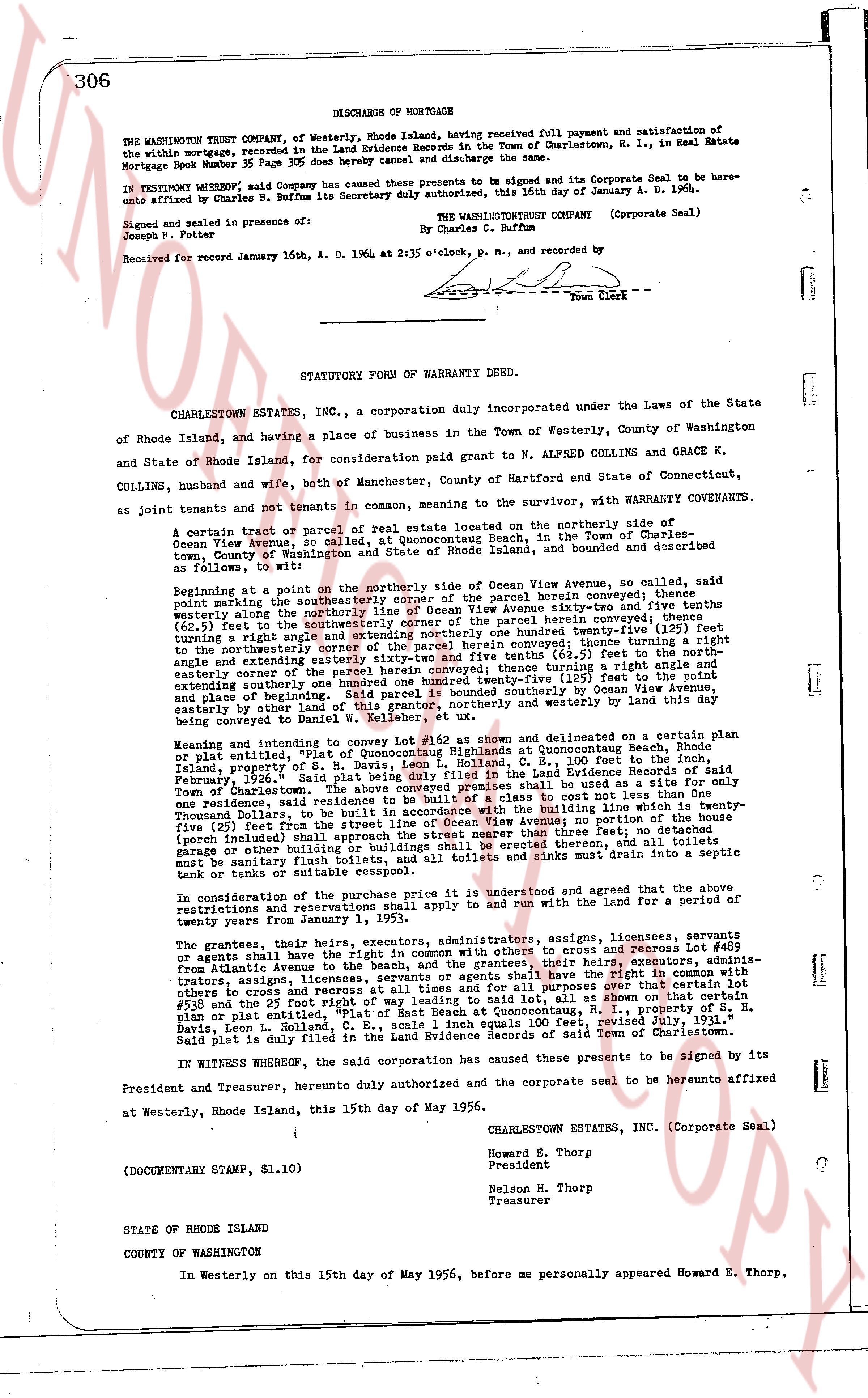
306
DISCHARGE OF MORTGAGE
THE WASHINGTON TRUST COMPANY, of Westerly, Rhode Island, having received full payment and satisfaction of the within mortgage, recorded in the Land Evidence Records in the Town of Charlestown, R. I., in Real Estate Mortgage Book number 35 page 305 here by cancel and discharge said lien.
IN TESTIMONY WHEREOF, said Company has caused these presents to be signed and its Corporate Seal to be hereunto affixed by Charles B. Buffum its Secretary duly authorized, this 16th day of January A. D. 1964.
THE WASHINGTONTRUST COMPANY (Corporate Seal)
By Charles C. Buffum
Signed, sealed and delivered in presence of:
Joseph N. Potter
Received for record January 16th, A. D. 1964; at 2:35 o'clock, p. m., and recorded by
[Signature]
Town Clerk
----
STATUTORY FORM OF WARRANTY DEED.
CHARLESTOWN ESTATES INC., a corporation duly incorporated under the Laws of the State of Rhode Island, and having a place of business in the Town of Westerly, County of Washington and State of Rhode Island, for consideration paid grant to N ALFRED COLLINS and GRACE K. COLLINS, husband and wife, both of Manchester, County of Hartford and State of Connecticut, as joint tenants and not tenants in common, mentioning to the survivor, with WARRANTY COVENANTS.
A certain tract or parcel of real estate located on the northerly side of Ocean View Avenue, situated, at Quonsetquogue Beach, in the Town of Charlestown, County of Washington and State of Rhode Island, described and bounded as follows:
wotit beginning at a point on the northerly side of Ocean View Avenue, so called, said point being marked by the northeasterly corner of the parcel herein conveyed; thence northerly along the northerly line of Ocean View Avenue sixty-two and thirty-five 100ths (62.35) feet to the southeast corner of the parcel herein conveyed; thence turning a right angle and extending northerly one hundred twenty-five (125) feet turning a right angle and extending northwesterly one hundred twenty-five and five tenths (125.5) feet to the northeasterly corner of the parcel herein conveyed; thence turning a right angle and extending southwesterly one hundred twenty-five and five tenths (125.5) feet to the easterly corner of the parcel herein conveyed; thence turning a right angle and extending southerly one hundred twenty-five (125) feet to the point of beginning. Said parcel is bounded southerly by Ocean View Avenue extending easterly by other land and northerly and westerly by land this day being conveyed to Daniel W. Kelleher, et ux.
Meaning and intending to convey Lot #52 as shown and delineated on a certain Beach plan or plat entitled, "The Ocean Highlands at Quonsetquogue Beach, Town of Charlestown, Rhode Island, property of S. H. Davis, Leon L. Holland, C. E., 100 feet to the Scale" found in the Land Evidence Records of said Town of Charlestown, page 204, Vol. 2. The above conveyed premises shall be used as a site for only one residence, said residence to be of a type conforming to cost laws of the State of Rhode Island. Said residence to be built in accordance with the building line which is twenty-five (25) feet from the street line of Ocean View Avenue; no portion (porch included) shall extend closer to street nearer than three feet; no detached garage or other building or buildings shall be erected therein, and all toilets shall drain into a septic tank or tanks or suitable sewage.
In consideration of the purchase price it is understood and agreed that the above restrictions and reservations are applicable to and apply to and will run with the land for a period of twenty years from January 1, 1955.
The grantees, their heirs, executors, administrators, assigns, licensees, servants we shall have the free and unobstructed right of way in common with others to cross and recross Lot #48 from Atlantic Avenue to the beach, and the grantees, their heirs, executors, administrators, assigns, licensees, servants we shall have the free and unobstructed right of way in common with others to cross and recross at all times and for all purposes over that certain lot or parcel identified as Lot #53 and the 25 foot Right of Way.
Meaning and intending to convey Lot #48 and Lot #53 as shown and delineated on a certain Beach plan or plat entitled, "The Ocean Highlands at Quonsetquogue Beach, Town of Charlestown, Rhode Island, property of S. H. Davis, Leon L. Holland, C. E., scale 1 inch equals 100 feet, verified by Leon L. Holland, C. E., said plat is duly filed in the land records of said Town of Charlestown. Said lot is duly platted.
IN WITNESS WHEREOF, the said corporation has caused these presents to be signed by its President and Treasurer, hereunto duly authorized and the corporate seal to be hereunto affixed
at Westerly, Rhode Island, this 15th day of May 1956.
CHARLESTOWN ESTATES, INC. (Corporate Seal)
Howard E. Thorp
President
Nelson N. Thorp
Treasurer
(DOCUMENTARY STAMP, $1.10)
STATE OF RHODE ISLAND
COUNTY OF WASHINGTON
In Westerly on this 15th day of May 1956, before me personally appeared Howard E. Thorp,
page 2 · read by Gemma vision
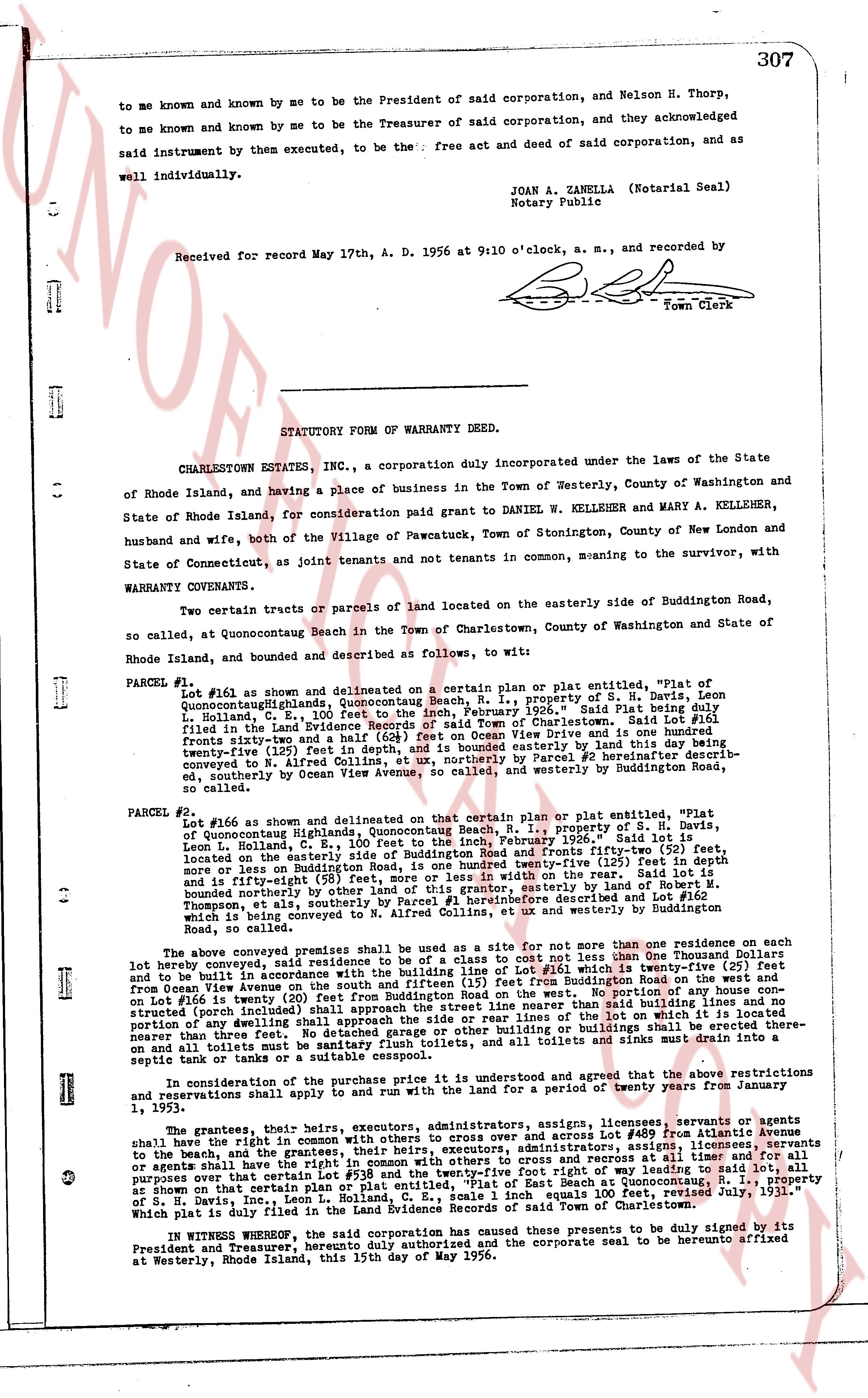
307
to me known and known by me to be the President of said corporation, and Nelson H. Thorp,
to me known and known by me to be the Treasurer of said corporation, and they acknowledged
said instrument by them executed, to be the: free act and deed of said corporation, and as
well individually.
JOAN A. ZANELLA (Notarial Seal)
Notary Public
Received for record May 17th, A. D. 1956 at 9:10 o'clock, a. m., and recorded by
[Signature]
Town Clerk
----
STATUTORY FORM OF WARRANTY DEED.
CHARLESTOWN ESTATES, INC., a corporation duly incorporated under the laws of the State
of Rhode Island, and having a place of business in the Town of Westerly, County of Washington and
State of Rhode Island, for consideration paid grant to DANIEL W. KELLEHER and MARY A. KELLEHER,
husband and wife, both of the Village of Pawcatuck, Town of Stonington, County of New London and
State of Connecticut, as joint tenants and not tenants in common, meaning to the survivor, with
WARRANTY COVENANTS.
Two certain tracts or parcels of land located on the easterly side of Buddington Road,
so called, at Quonocutaug Beach in the Town of Charlestown, County of Washington and State of
Rhode Island, bounded and described as follows, to wit:
PARCEL #1 Lot #161 as shown and delineated on a certain plan or plat entitled "Map of
QuonocutaugQuonocutaug, Quonocutaug Beach, R. I., property of S. H. Davis", dated
June 1936, and filed in the Land Evidence Records of said Town of Charlestown. Said Lot #161 being
filed in the Land Evidence Records of said Town of Charlestown. Said Lot #161 being
fronts sixty-twelve and a half (62 1/2) feet on Ocean View Drive and is conveyed hereby by this land dey being
twenty-five (25) feet deep from Ocean View Drive and is conveyed hereby by this land dey being
twenty-five (25) feet deep from Ocean View Drive and is conveyed hereby by this land dey being
conveyed to N. Alfred Collins, et ux, northerly by Parcel #2 hereinafter described her-
inafter, southerly by Ocean View Avenue, so called, and westerly by Buddington Road,
so called.
PARCEL #2 Lot #166 as shown and delineated on that certain plan or plat entitled "Map of
Quonocutaug Highlands, Quonocutaug Beach, R. I., property of S. H. Davis", dated
June 1936, and filed in the Land Evidence Records of said Town of Charlestown. Said Lot #166 is
located on the easterly side of Buddington Road and fronts fifty-two (52) feet, more
or less or less in width on the rear. Said lot is
and is further eight (58) feet, more or less in width on the rear. Said lot is
bounded northerly by the land of Ocean View Drive, easterly, by lot #146 Said lot is
bounded northerly by the land of Ocean View Drive, easterly, by lot #146
bounded northerly by the land of Ocean View Drive, easterly, by lot #146
bounded northerly by the land of Ocean View Drive, easterly, by lot #146
bounded northerly by the land of Ocean View Drive, easterly, by lot #146
bounded northerly by the land of Ocean View Drive, easterly, by lot #146
bounded northerly by the land of Ocean View Drive, easterly, by lot #146
bounded northerly by the land of Ocean View Drive, easterly, by lot #146
bounded northerly by the land of Ocean View Drive, easterly, by lot #146
bounded northerly by the land of Ocean View Drive, easterly, by lot #146
bounded northerly by the land of Ocean View Drive, easterly, by lot #146
bounded northerly by the land of Ocean View Drive, easterly, by lot #146
bounded northerly by the land of Ocean View Drive, easterly, by lot #146
bounded northerly by the land of Ocean View Drive, easterly, by lot #146
bounded northerly by the land of Ocean View Drive, easterly, by lot #146
bounded northerly by the land of Ocean View Drive, easterly, by lot #146
bounded northerly by the land of Ocean View Drive, easterly, by lot #146
bounded northerly by the land of Ocean View Drive, easterly, by lot #146
bounded northerly by the land of Ocean View Drive, easterly, by lot #146
bounded northerly by the land of Ocean View Drive, easterly, by lot #146
bounded northerly by the land of Ocean View Drive, easterly, by lot #146
bounded northerly by the land of Ocean View Drive, easterly, by lot #146
bounded northerly by the land of Ocean View Drive, easterly, by lot #146
bounded northerly by the land of Ocean View Drive, easterly, by lot #146
bounded northerly by the land of Ocean View Drive, easterly, by lot #146
bounded northerly by the land of Ocean View Drive, easterly, by lot #146
bounded northerly by the land of Ocean View Drive, easterly, by lot #146
bounded northerly by the land of Ocean View Drive, easterly, by lot #146
bounded northerly by the land of Ocean View Drive, easterly, by lot #146
bounded northerly by the land of Ocean View Drive, easterly, by lot #146
bounded northerly by the land of Ocean View Drive, easterly, by lot #146
bounded northerly by the land of Ocean View Drive, easterly, by lot #146
bounded northerly by the land of Ocean View Drive, easterly, by lot #146
bounded northerly by the land of Ocean View Drive, easterly, by lot #146
bounded northerly by the land of Ocean View Drive, easterly, by lot #146
bounded northerly by the land of Ocean View Drive, easterly, by lot #146
bounded northerly by the land of Ocean View Drive, easterly, by lot #146
bounded northerly by the land of Ocean View Drive, easterly, by lot #146
bounded northerly by the land of Ocean View Drive, easterly, by lot #146
bounded northerly by the land of Ocean View Drive, easterly, by lot #146
bounded northerly by the land of Ocean View Drive, easterly, by lot #146
bounded northerly by the land of Ocean View Drive, easterly, by lot #146
bounded northerly by the land of Ocean View Drive, easterly, by lot #146
bounded northerly by the land of Ocean View Drive, easterly, by lot #146
bounded northerly by the land of Ocean View Drive, easterly, by lot #146
bounded northerly by the land of Ocean View Drive, easterly, by lot #146
bounded northerly by the land of Ocean View Drive, easterly, by lot #146
bounded northerly by the land of Ocean View Drive, easterly, by lot #146
bounded northerly by the land of Ocean View Drive, easterly, by lot #146
bounded northerly by the land of Ocean View Drive, easterly, by lot #146
bounded northerly by the land of Ocean View Drive, easterly, by lot #146
bounded northerly by the land of Ocean View Drive, easterly, by lot #146
bounded northerly by the land of Ocean View Drive, easterly, by lot #146
bounded northerly by the land of Ocean View Drive, easterly, by lot #146
bounded northerly by the land of Ocean View Drive, easterly, by lot #146
bounded northerly by the land of Ocean View Drive, easterly, by lot #146
bounded northerly by the land of Ocean View Drive, easterly, by lot #146
bounded northerly by the land of Ocean View Drive, easterly, by lot #146
bounded northerly by the land of Ocean View Drive, easterly, by lot #146
bounded northerly by the land of Ocean View Drive, easterly, by lot #146
bounded northerly by the land of Ocean View Drive, easterly, by lot #146
bounded northerly by the land of Ocean View Drive, easterly, by lot #146
bounded northerly by the land of Ocean View Drive, easterly, by lot #146
bounded northerly by the land of Ocean View Drive, easterly, by lot #146
bounded northerly by the land of Ocean View Drive, easterly, by lot #146
bounded northerly by the land of Ocean View Drive, easterly, by lot #146
bounded northerly by the land of Ocean View Drive, easterly, by lot #146
bounded northerly by the land of Ocean View Drive, easterly, by lot #146
bounded northerly by the land of Ocean View Drive, easterly, by lot #146
bounded northerly by the land of Ocean View Drive, easterly, by lot #146
bounded northerly by the land of Ocean View Drive, easterly, by lot #146
bounded northerly by the land of Ocean View Drive, easterly, by lot #146
bounded northerly by the land of Ocean View Drive, easterly, by lot #146
bounded northerly by the land of Ocean View Drive, easterly, by lot #146
bounded northerly by the land of Ocean View Drive, easterly, by lot #146
bounded northerly by the land of Ocean View Drive, easterly, by lot #146
bounded northerly by the land of Ocean View Drive, easterly, by lot #146
bounded northerly by the land of Ocean View Drive, easterly, by lot #146
bounded northerly by the land of Ocean View Drive, easterly, by lot #146
bounded northerly by the land of Ocean View Drive, easterly, by lot #146
bounded northerly by the land of Ocean View Drive, easterly, by lot #146
bounded northerly by the land of Ocean View Drive, easterly, by lot #146
bounded northerly by the land of Ocean View Drive, easterly, by lot #146
bounded northerly by the land of Ocean View Drive, easterly, by lot #146
bounded northerly by the land of Ocean View Drive, easterly, by lot #146
bounded northerly by the land of Ocean View Drive, easterly, by lot #146
bounded northerly by the land of Ocean View Drive, easterly, by lot #146
bounded northerly by the land of Ocean View Drive, easterly, by lot #146
bounded northerly by the land of Ocean View Drive, easterly, by lot #146
bounded northerly by the land of Ocean View Drive, easterly, by lot #146
bounded northerly by the land of Ocean View Drive, easterly, by lot #146
bounded northerly by the land of Ocean View Drive, easterly, by lot #146
bounded northerly by the land of Ocean View Drive, easterly, by lot #146
bounded northerly by the land of Ocean View Drive, easterly, by lot #146
bounded northerly by the land of Ocean View Drive, easterly, by lot #146
bounded northerly by the land of Ocean View Drive, easterly, by lot #146
bounded northerly by the land of Ocean View Drive, easterly, by lot #146
bounded northerly by the land of Ocean View Drive, easterly, by lot #146
bounded northerly by the land of Ocean View Drive, easterly, by lot #146
bounded northerly by the land of Ocean View Drive, easterly, by lot #146
bounded northerly by the land of Ocean View Drive, easterly, by lot #146
bounded northerly by the land of Ocean View Drive, easterly, by lot #146
bounded northerly by the land of Ocean View Drive, easterly, by lot #146
bounded northerly by the land of Ocean View Drive, easterly, by lot #146
bounded northerly by the land of Ocean View Drive, easterly, by lot #146
bounded northerly by the land of Ocean View Drive, easterly, by lot #146
bounded northerly by the land of Ocean View Drive, easterly, by lot #146
bounded northerly by the land of Ocean View Drive, easterly, by lot #146
bounded northerly by the land of Ocean View Drive, easterly, by lot #146
bounded northerly by the land of Ocean View Drive, easterly, by lot
The page as recorded