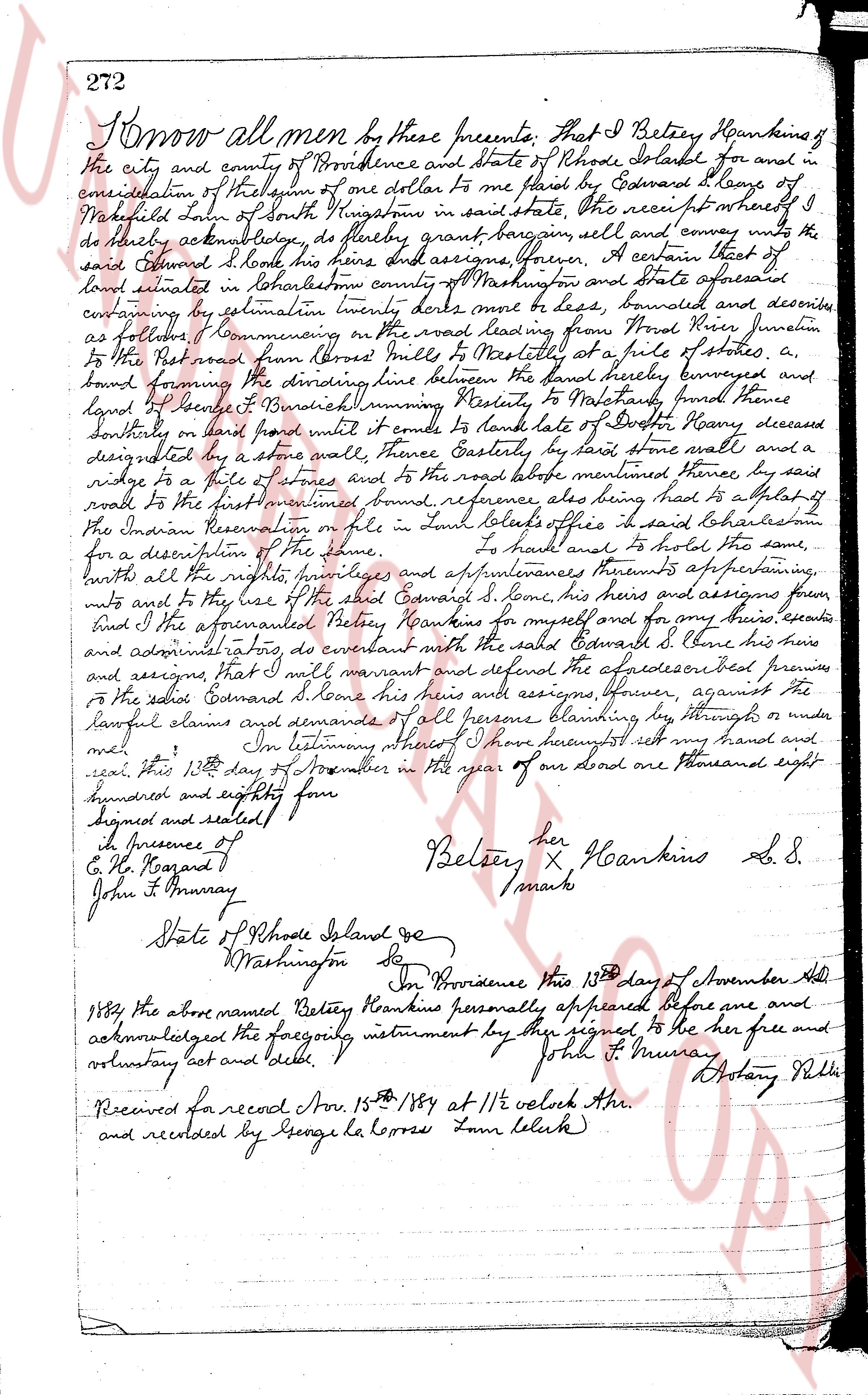
The instrument's own words
page 1
272
Know all men by these presents. That I Betsey Hankins of
the city and county of Providence and state of Rhode Island for and in
consideration of the sum of one dollar to me paid by Edward S. Covey of
Mashpee Town in state of Massachusetts in hand witness whereof I
do hereby acknowledge, to have bargained, given, sold and convey unto the
said Edward S. Covey his heirs and assigns forever, A certain tract of
land situated in Rhodehouse country of Washington and state aforesaid
containing by estimation twenty decres more or less, bounded and described
as follows, commencing on the road leading from Providence to North
Kingstown at the first marked found herein junction
to the road running from Cross Mill to Narragansett at a pile of stones, a
bound forming the dividing line between the land hereby conveyed and
land of Benedict S. Benedict running thence Easterly to Washington fence
southerly on land found white until it comes to land of Dexter Kenny deceased
designated by a stone wall thence Easterly by said stone wall and a
ridge to a pile of stones and to the road before mentioned thence, by said
road to the first mentioned found reference also being had to a plat of
the Indian Reservation on file in town clerks office in said Rhodehouse
for a description of the same. To have and to hold the same,
with all the rights, privileges and appurtenances thereunto appertaining,
unto and to the use of the said Edward S. Covey his heirs and assigns forever
And I the undersigned Betsey Hankins for myself and for my heirs, executors
and administrators do covenant with the said Edward S. Covey his heirs and
assigns that I will warrant and defend the expressed premises
to the said Edward S. Covey his heirs and assigns, forever, against the
lawful claims and demands of all persons claiming by through or under
me. In testimony whereof I have hereunto set my hand and
seal, this 13th day of November in the year of our Lord one thousand eight
hundred and eighty four
signed and sealed
In presence of
C. H. Hazard
John T. Murray
Betsey X Hankins S. S.
her
/mark
State of Rhode Island ss
Washington Co ss
On Providence this 13th day of November Ad
1884 the above named Betsey Hankins personally appeared before me and
acknowledged the foregoing instrument by her signed to be her free and
voluntary act and deed.
John T. Murray Notary Public
Received for record Nov. 15th 1884 at 11 1/2 o'clock A.M.
and recorded by George H. Lopes Town Clerk
page 2
307
to me known and known by me to be the President of said corporation, and Nelson H. Thorp,
to me known and known by me to be the Treasurer of said corporation, and they acknowledged
said instrument by them executed, to be the: free act and deed of said corporation, and as
well individually.
JOAN A. ZANELLA (Notarial Seal)
Notary Public
Received for record May 17th, A. D. 1956 at 9:10 o'clock, a. m., and recorded by
[Signature]
Town Clerk
STATUTORY FORM OF WARRANTY DEED.
CHARLESTOWN ESTATES, INC., a corporation duly incorporated under the laws of the State
of Rhode Island, and having a place of business in the Town of Westerly, County of Washington and
State of Rhode Island, for consideration paid grant to DANIEL W. KELLEHER and MARY A. KELLEHER,
husband and wife, both of the Village of Pawcatuck, Town of Stonington, County of New London and
State of Connecticut, as joint tenants and not tenants in common, meaning to the survivor, with
WARRANTY COVENANTS.
Two certain tracts or parcels of land located on the easterly side of Buddington Road,
so called, at Quonocuttaugh Beach in the Town of Charlestown, County of Washington and State of
Rhode Island, bounded and described as follows, to wit:
PARCEL #1 [crossed out] The #161 as shown and delineated on a certain plan or plat entitled "Map of
Quonocuttaugh Highlands, Quonocuttaugh Beach, R. I., property of S. H. Davis, loan
L. Holland, P. C. dated July 1931, scale 1" = 200 feet" dated February 1956. Said Lot being
filed in the Land Evidence Records of said Town of Charlestown. Said Lot #161 being
fronts sixty-two and a half (62.5) feet on Ocean View Drive and is bounded westerly by land this day being
twenty-five (25) feet deep and is bounded easterly by land this day being
twenty-five (25) feet deep and is bounded southerly by Parcel #2 hereinafter described
conveyed to N. Albert Oliveness, et ux, northerly by Parcel #2 hereinafter described con-
veyed, southerly by Ocean View Avenue, so called, and easterly by Buddington Road,
so called.
PARCEL #2
Lot #166 as shown and delineated on that certain plan or plat entitled "Map of Plat
of Quonocuttaugh Highlands, Quonocuttaugh Beach, R. I., property of S. H. Davis, loan
L. Holland, P. C. dated July 1931, scale 1" = 200 feet" dated February 1956. Said Lot is
located on the easterly side of Buddington Road and fronts fifty-two (52) feet, more or less
located on the easterly side of Buddington Road and fronts fifty-two (52) feet, more or less
or less in width on the front, and is forty-seven (47) feet, more or less in width on the rear.
Said lot is
and is furthert (58) feet, more or less in width on the rear. Said lot is
bounded northerly by that land this day being conveyed, easterly by land of
Thompson, and is bounded southerly by Parcel #1 heretofore described and Lot #162
which is being conveyed to N. Albert Oliveness, et ux and westerly by Buddington Road,
so called.
The above conveyed premises shall be used as a site for not more than one (1) residence on each
lot hereby conveyed, subject to a reservation of a class to contain not more than One Thousand Dwellers
on the built up area. The building site for the residence on Lot #161 which is twenty-five (25) feet
from Ocean View Avenue on the south and fifteen (15) feet from Buddington Road on the east
shall be restricted to a building site of 50' x 100'. No other building of any kind nor any house con-
structed (porch included) shall approach the street line nearer than said building lines and no
portion of any shower, screen porch, garage, carport, etc. shall be erected within the restricted
zone of three feet. No detached garage or other building or buildings shall be erected there-
on and all toilets must be septic tanks approved by the town, and all toilets and sinks must drain into a
septic tank or tile outlet or suitable cesspool.
In consideration of the purchase price it is understood and agreed that the above restrictions
and reservations shall apply to and run with the land for a period of twenty years from this date.
The grantors, their heirs, executors, administrators, assigns, licensees, servants or agents
shall have the right in common with others to cross and cross over Lot #166 from Atlantic Ave
to the beach, and the grantees, their heirs, executors, administrators, assigns, licensees, servants
or agents shall have the right in common with others to cross and cross at recesses at all times
over that portion of Lot #166 which is bounded on the north by Buddington Road, referring to said lot, all
as shown on that certain plan or plat entitled "Map of Plat of East Beach at Quonocuttaugh, R. I., property
of S. H. Davis, loan L. Holland, P. C. dated July 1931, scale 1" = 200 feet" dated July 1931,
which plan is duly filed in the Land Evidence Records of said Town of Charlestown.
IN WITNESS WHEREOF, the said corporation has caused the presents to be duly signed by its
President and Treasurer, hereunto duly authorized and the corporate seal to be heretofore affixed
at Westerly, Rhode Island, this 15th day of May 1956.
The page as recorded