The instrument's own words
page 1 · read by Gemma vision
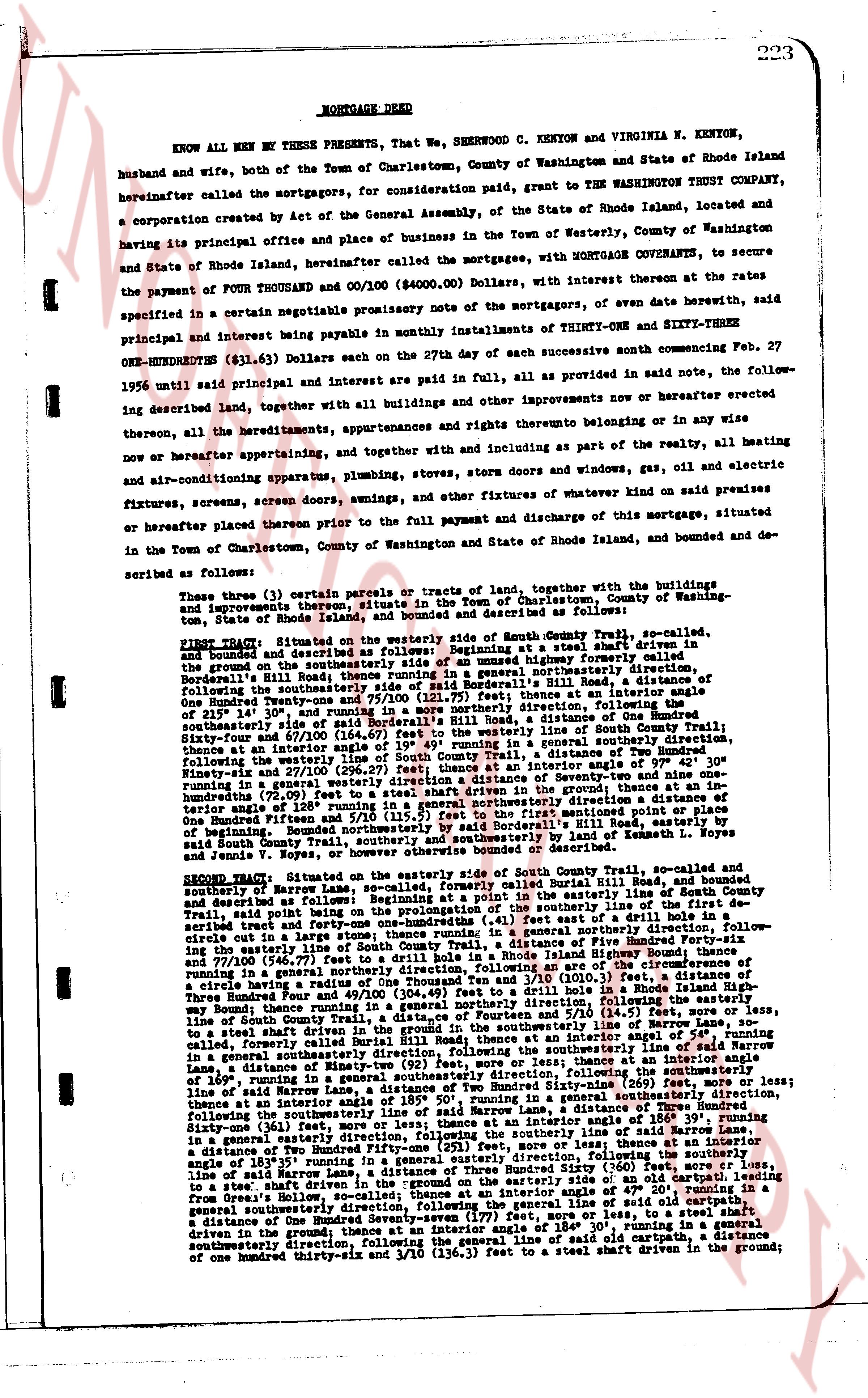
223
MORTGAGE DEED
KNOW ALL MEN BY THESE PRESENTS, That We, SHERWOOD C. KENYON and VIRGINIA N. KENYON, husband and wife, both of the Town of Charlestown, County of Washington and State of Rhode Island hereinafter called the mortgagors, for consideration paid, grant to THE WASHINGTON TRUST COMPANY, a corporation created by Act of the General Assembly, of the State of Rhode Island, located and having its principal office and place of business in the Town of Westerly, County of Washington and State of Rhode Island, hereinafter called the mortgagee, with MORTGAGE COVENANTS, to secure the payment of FOUR THOUSAND and 00/100 ($4000.00) Dollars, with interest thereon at the rate specified in a certain negotiable promissory note of the mortgagors, of an even date herewith, said principal and interest being payable in monthly installments of THIRTY-ONE and SIXTY-THREE ONE-HUNDREDTHS ($31.63) Dollars each on the 27th day of each successive month commencing Feb. 27 1956 until said principal and interest are paid in full, all as provided in said note, the following described land, together with all buildings and other improvements now or hereafter erected thereon, all the hereditaments, appurtenances and rights thereto belonging or in any wise now or hereafter appertaining, and together with and including as part of the realty, all heating and air-conditioning apparatus, plumbing, stoves, stora doors and windows, gas, oil and electric fixtures, screens, screen doors, swings, and other fixtures of whatever kind now on said premises or hereafter placed thereon prior to the full payment and discharge of this mortgage, situated in the Town of Charlestown, County of Washington and State of Rhode Island, bounded and described as follows:
Three (3) parcels (or certain parcels or tracts of land), together with the buildings and improvements thereon, situated in the Town of Charlestown, County of Washington tenement, State of Rhode Island, bounded and described as follows:
FIRST TRACT: Situated on the westerly side of South County Trail, so called, and bounded and described as follows: Beginning at a stake driven in the ground on the southeasterly side of a highway formerly called Bordell's Hill Road; thence running in a general northerly direction, following said highway, to a stake driven in the ground on said Bordell's Hill Road, a distance of One Hundred Ninety-three and 75/100 (193.75) feet; thence at an interior angle of 215° running in a general easterly direction, to a stake driven in the ground on the southeasterly side of said Bordell's Hill Road, a distance of One Hundred Twenty-three and 75/100 (123.75) feet; thence at an interior angle of 219° running in a general southerly direction, following the line of South County Trail, Sixty-four and 57/100 (64.57) feet; thence at an interior angle of 309° running in a general southerly direction, following the westerly line of South County Trail, a distance of 115 feet; thence at an interior angle of 97° at an interior angle of 97° 42' 30" running in a general westerly direction, a distance of Seventy-nine and 00/100 (79.00) feet; thence at an interior angle of 180° running in a general westerly direction a distance of 110 feet to a stake driven in the ground; thence at an interior angle of 120° running in a general northerly direction to the stake first mentioned point or place of beginning. Bounded northerly by said Bordell's Hill Road; easterly by South County Trail; southerly by land of Kenneth L. Noyes and Jenna V. Noyes, or however otherwise bounded or described.
SECOND TRACT: Situated on the easterly side of South County Trail, so called, and bounded and described as follows: Beginning at a point in the easterly line of said South County Trail, said point being a stake driven in the ground on said South County Trail, Road, bounded and described as follows: Beginning at a point in the easterly line of said South County Trail, said point being a stake driven in the ground on said South County Trail, Road, bounded and described as follows: Beginning at a point in the easterly line of said South County Trail, a distance of forty-one and one-hundredths (41) feet east of a drill hole driven in the ground; thence running in a general northerly direction, following the said drill hole in a large sum; thence running in a general northerly direction, following the line of South County Trail, a distance of Five Hundred Forty-six and 57/100 (546.57) feet to a drill hole driven in the ground; thence at an interior angle of the circumference of running in a general easterly direction, following the line of South County Trail, a distance of One Hundred Three and 1/100 (103.01) feet to a drill hole in a Rhode Island Highway boundary; thence running in a general northerly direction, following the line of said Highway boundary, Three hundred and twenty-one and 11/100 (321.11) feet to a stake driven in the ground; thence at an interior angle of 54° 10' running in a general easterly direction, a distance of 519.0 (519) feet, more or less; thence running in a general southeasterly direction, following the line of said Highway boundary, at an interior angle of 54°, running in a general southeasterly direction, following the southeasterly line of said Highway boundary to a stake driven in the ground; thence at an interior angle of 180° running in a general southerly direction, a distance of 169', running in a general southeasterly direction, following the southeasterly line, following the southeasterly line of said Highway boundary, a distance of 169', running in a general southeasterly direction, following the southeasterly line, following the southeasterly line of said Highway boundary, a distance of 169', running in a general southeasterly direction, following the southeasterly line, following the southeasterly line of said Highway boundary, a distance of 169', running in a general southeasterly direction, following the southeasterly line, following the southeasterly line of said Highway boundary, a distance of 169', running in a general southeasterly direction, following the southeasterly line, following the southeasterly line of said Highway boundary, a distance of 169', running in a general southeasterly direction, following the southeasterly line, following the southeasterly line of said Highway boundary, a distance of 169', running in a general southeasterly direction, following the southeasterly line, following the southeasterly line of said Highway boundary, a distance of 169', running in a general southeasterly direction, following the southeasterly line, following the southeasterly line of said Highway boundary, a distance of 169', running in a general southeasterly direction, following the southeasterly line, following the southeasterly line of said Highway boundary, a distance of 169', running in a general southeasterly direction, following the southeasterly line, following the southeasterly line of said Highway boundary, a distance of 169', running in a general southeasterly direction, following the southeasterly line, following the southeasterly line of said Highway boundary, a distance of 169', running in a general southeasterly direction, following the southeasterly line, following the southeasterly line of said Highway boundary, a distance of 169', running in a general southeasterly direction, following the southeasterly line, following the southeasterly line of said Highway boundary, a distance of 169', running in a general southeasterly direction, following the southeasterly line, following the southeasterly line of said Highway boundary, a distance of 169', running in a general southeasterly direction, following the southeasterly line, following the southeasterly line of said Highway boundary, a distance of 169', running in a general southeasterly direction, following the southeasterly line, following the southeasterly line of said Highway boundary, a distance of 169', running in a general southeasterly direction, following the southeasterly line, following the southeasterly line of said Highway boundary, a distance of 169', running in a general southeasterly direction, following the southeasterly line, following the southeasterly line of said Highway boundary, a distance of 169', running in a general southeasterly direction, following the southeasterly line, following the southeasterly line of said Highway boundary, a distance of 169', running in a general southeasterly direction, following the southeasterly line, following the southeasterly line of said Highway boundary, a distance of 169', running in a general southeasterly direction, following the southeasterly line, following the southeasterly line of said Highway boundary, a distance of 169', running in a general southeasterly direction, following the southeasterly line, following the southeasterly line of said Highway boundary, a distance of 169', running in a general southeasterly direction, following the southeasterly line, following the southeasterly line of said Highway boundary, a distance of 169', running in a general southeasterly direction, following the southeasterly line, following the southeasterly line of said Highway boundary, a distance of 169', running in a general southeasterly direction, following the southeasterly line, following the southeasterly line of said Highway boundary, a distance of 169', running in a general southeasterly direction, following the southeasterly line, following the southeasterly line of said Highway boundary, a distance of 169', running in a general southeasterly direction, following the southeasterly line, following the southeasterly line of said Highway boundary, a distance of 169', running in a general southeasterly direction, following the southeasterly line, following the southeasterly line of said Highway boundary, a distance of 169', running in a general southeasterly direction, following the southeasterly line, following the southeasterly line of said Highway boundary, a distance of 169', running in a general southeasterly direction, following the southeasterly line, following the southeasterly line of said Highway boundary, a distance of 169', running in a general southeasterly direction, following the southeasterly line, following the southeasterly line of said Highway boundary, a distance of 169', running in a general southeasterly direction, following the southeasterly line, following the southeasterly line of said Highway boundary, a distance of 169', running in a general southeasterly direction, following the southeasterly line, following the southeasterly line of said Highway boundary, a distance of 169', running in a general southeasterly direction, following the southeasterly line, following the southeasterly line of said Highway boundary, a distance of 169', running in a general southeasterly direction, following the southeasterly line, following the southeasterly line of said Highway boundary, a distance of 169', running in a general southeasterly direction, following the southeasterly line, following the southeasterly line of said Highway boundary, a distance of 169', running in a general southeasterly direction, following the southeasterly line, following the southeasterly line of said Highway boundary, a distance of 169', running in a general southeasterly direction, following the southeasterly line, following the southeasterly line of said Highway boundary, a distance of 169', running in a general southeasterly direction, following the southeasterly line, following the southeasterly line of said Highway boundary, a distance of 169', running in a general southeasterly direction, following the southeasterly line, following the southeasterly line of said Highway boundary, a distance of 169', running in a general southeasterly direction, following the southeasterly line, following the southeasterly line of said Highway boundary, a distance of 169', running in a general southeasterly direction, following the southeasterly line, following the southeasterly line of said Highway boundary, a distance of 169', running in a general southeasterly direction, following the southeasterly line, following the southeasterly line of said Highway boundary, a distance of 169', running in a general southeasterly direction, following the southeasterly line, following the southeasterly line of said Highway boundary, a distance of 169', running in a general southeasterly direction, following the southeasterly line, following the southeasterly
page 2 · read by Gemma vision
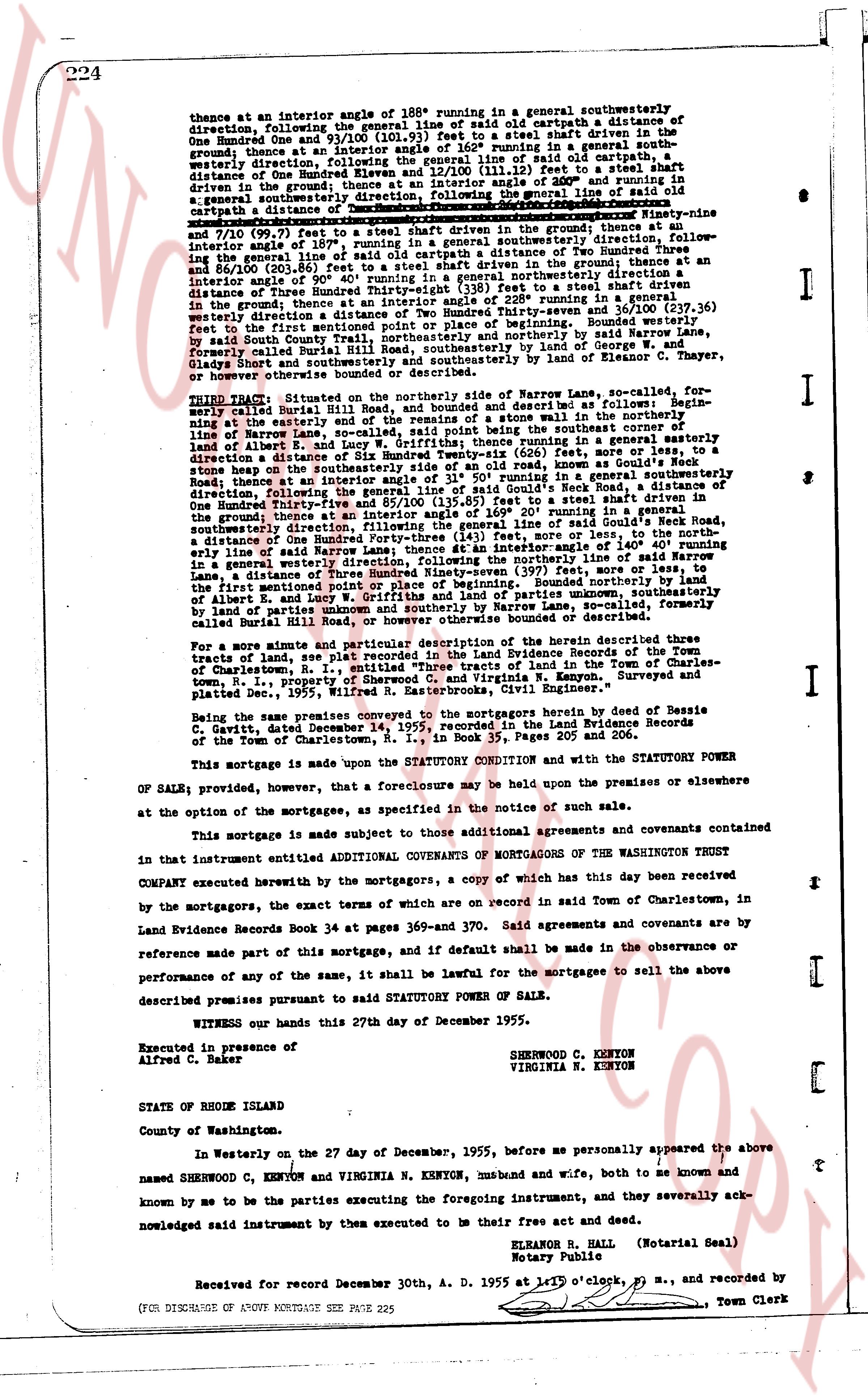
thence at an interior angle of 188° running in a general southwesterly
direction, following the general line of said old cartpath a distance of
One Hundred and One and 71/100 (101.71) feet to a steel shaft driven in the
ground; thence at an interior angle of 162° running in a general south-
westerly direction, following the general line of said old cartpath a distance of
One Hundred and Nine and 71/100 (109.71) feet to a steel shaft driven in the
ground; thence at an interior angle of 111/100 (111.12) feet to a steel shaft
driven in the ground; thence at an interior angle of 30° and running in a general
southwesterly direction, following the general line of said old cartpath a
cartpath a distance of One Hundred and Nine and 71/100 (109.71) feet; thence
Ninety-nine
and 7/100 (99.7) feet to a steel shaft driven in the ground; thence at an
interior angle of 180° running in a general southwesterly direction, follow-
ing the general line of said line said cartpath a distance of Two Hundred and
Three and 84/100 (203.84) feet to a steel shaft driven in the ground; thence at an
interior angle of 90° running in a general northeasterly direction with a
distance of One Hundred and Nine feet to a steel shaft driven in the
ground; thence at an interior angle of 228° running in a general northeasterly
direction, following the general line of said cartpath (107.27) feet; following
westerly direction to the point of place of beginning. Bounded westerly
feet by said South County National Bank, southerly and northeasterly by
formerly called Burleigh Road, and easterly by land of George W. and
Olgaey Short and southeasterly and southwesterly by land of Eleanor C. Thayer,
or heirs general thereunto.
THIRD TRACT: Situated on the northeasterly side of Narrow Lane, so-called, for-
merly called Buriel 313 Road, and bounded and described as follows: Begin-
ning at the easterly corner of a stone wall in the northeasterly line of
Narrow Lane, so called, said point being the southeasterly corner of
said lot; thence at an interior angle of 30° running in a general northeasterly
direction a distance of Six Hundred Twenty-eight (628) feet, more or less, to a
stone heap on the northeasterly line of said lot; thence at an interior angle of
31° running in a general southeasterly direction, along the easterly line of
Narrow Road thence at an interior angle of 85/100 (135.85) feet to a steel shaft driven in
the ground; thence at an interior angle of 30° running in a general south-
easterly direction, following the general line of said Guide's Neck Road, in
a distance of One Hundred Forty-three (143) feet, more or less, to a
steel shaft driven in the ground; thence at an interior angle of 140° running
line ally of said Narrow Lane, so called, a distance of One Hundred and Forty (140)
distance of One Hundred and Forty-seven (147) feet, more or less, to
line of said Narrow Lane, so called, a distance of One Hundred and Forty-seven (147) feet, more or less, to
the first mentioned point or place of beginning. Bounded northeasterly by land of
Alfred C. Baker and southerly by land of parties unknown, including
by land of parties unknown and southerly by Narrow Lane, so called, formerly
called Buriel 313 Road, and easterly and westerly bounded or described.
For more amute and particular description of the herein described three
tracts of land, see plat recorded in the Land Evidence Books of the town
of Charlestown, R.I., in the office of the Recorder of Land in the Town Clerk's
office, Town, i.e., property of Sherwood C. and Virginia N. Kenyon. Surveyed and
platted, Dec. 1955, Wilfred R. Easterbrooks, Civil Engineer.
Being the same premises conveyed to the Grantors hereby by deed of Bessie R.
Kenyon, dated December 18, 1936, recorded in the Land Evidence Records
of the Town of Charlestown, R.I., in Book 35, Pages 205 and 206.
This mortgage is made upon the STATUTORY CONDITION and with the STATUTORY POWER
OF SALE; provided, however, that a foreclosure may be held upon the premises or elsewhere
at the option of the mortgagee, as specified in the notice of such sale.
This mortgage is made subject to those additional agreements and covenants contained
in that instrument entitled COVENANTS OF MORTGAGORS OF THE WASHINGTON TRUST
COMPANY executed herewith by the mortgagors, a copy of which has this day been received
by the mortgagors, the exact terms of which are on record in said Town of Charlestown, in
Land Evidence Records Book 34 at pages 369-and 370. Said agreements and covenants are by
reference made part of this mortgage, and if default shall be made in the observance or
performance of any of the same, it shall be lawful for the mortgagee to sell the above
described premises pursuant to said STATUTORY POWER OF SALE.
WITNESS our hands this 27th day of December 1955.
Executed in presence of
Alfred C. Baker
SHERWOOD C. KENYON
VIRGINIA N. KENYON
STATE OF RHODE ISLAND
County of Washington.
In Westerly on the 27 day of December, 1955, before me personally appeared the above
named SHERWOOD C. KENYON and VIRGINIA N. KENYON, husband and wife, both to me known and
known by me to be the parties executing the foregoing instrument, and they severally ack-
nowledged said instrument by them executed to be their free act and deed.
ELIMAR B. HALL (Notarial Seal)
Notary Public
Received for record December 30th, A. D. 1955 at 1:19 o'clock, p. m., and recorded by
[?] Town Clerk
(FOR DISCHARGE OF ABOVE MORTGAGE SEE PAGE 225
The page as recorded