The Deed Walker · From Ninigret · Charlestown, Rhode Island land evidence, 1738 to today
Trail: 112@27/641 › 18@29/180 › 47@29/216

5/20/1944 · DEED · book 29 page 216 doc 47@29/216

From BROWN ALBERT E life
To WILLIAMS CHARLES H life, WILLIAMS MAXINE H
Premises none · Lot on northerly side of State Highway (Carolina, Wood River Junction, Charlestown)
Index description SEE DOC

Back — where this land came from

deed Fred H. Kenyon and Maud L. Kenyon et ux book 29 p 237 Charlestown
“conveyed by deed from Fred H. Kenyon and Maud L. Kenyon et ux to myself and Myrtle E. Pratt”
◀ Follow back 1944 · DEED · KENYON FRED H; KENYON MAUDE B → PRATT MYRTLE E; PRATT OSCAR C · book 29 p 237
read by: gemma

The grantor's earlier acquisitions, by name — the man, not necessarily this land

◀ 1944 · DEED · WILLIAMS CHARLES H; WILLIAMS MAXINE H → BROWN ALBERT E · book 29 p 215
◀ 1944 · DEED · CROSS CELIA M; CROSS WILLIAM D; BARBER EMMA E; CROSS GEORGE W DECEASED → BROWN ALBERT E · book 29 p 180
◀ 1944 · DEED · BARBER EMMA E → BROWN ALBERT E · book 29 p 295
◀ 1943 · DEED · MALLOY EDITH L; KENYON JOSEPHINE; MALLOY JOSEPH M; KENYON GILES P DECE → BROWN ALBERT E · book 29 p 46
◀ 1943 · DEED · WEBSTER MABEL F; WEBSTER CHARLES C → BROWN ALBERT E · book 29 p 119
◀ 1943 · DEED · BERESFORD CORA K; BERESFORD ERNEST R → BROWN ALBERT E · book 29 p 148
◀ 1942 · MORTGAGE · FENNER EDWIN R; FENNER JULIA E → BROWN ALBERT E · book 29 p 9
◀ 1942 · DEED · ODONNELL RUTH M; ODONNELL EUGENE C SR → BROWN ALBERT E · book 28 p 623
◀ 1942 · DEED · TUCKER IVAH B; TUCKER LOUIS G → BROWN ALBERT E · book 28 p 628
◀ 1938 · DEED · PIETILA MARY K; PIETILA MICHAEL → BROWN ALBERT E · book 27 p 273
◀ 1938 · DEED · MAYO FRANCES; MAYO JAMES → BROWN ALBERT E · book 27 p 287
◀ 1938 · MORTGAGE · SMITH JOHN W; SMITH MABEL F → BROWN ALBERT E · book 27 p 358
◀ 1938 · MORTGAGE · SMITH JOHN W; SMITH MABEL F → BROWN ALBERT E · book 27 p 422
◀ 1937 · DEED · BLIVEN ANNIE; BLIVEN GEORGE W → BROWN ALBERT E · book 27 p 78

Forward — where this land went

The grantee's later conveyances, by name — the man, not necessarily this land; the one that cites this deed as its source is the land

▶ 1944 · DEED · WILLIAMS CHARLES H; WILLIAMS MAXINE H → BROWN ALBERT E · book 29 p 215
▶ 1946 · MORTGAGE · WILLIAMS CHARLES H; WILLIAMS MAXINE H → WESTERLY SAVINGS FUND AND LOAN ASSOC · book 30 p 54
▶ 1949 · AGREEMENT · WILLIAMS CHARLES H; WILLIAMS MAXINE H → NARRAGANSETT ELECTRIC COMPANY · book 31 p 530
▶ 1979 · DEED · WILLIAMS CHARLES H; WILLIAMS MAXINE H → NIGRELLI SANDRA L · book 60 p 680
▶ 1984 · CERTIFICATE · WILLIAMS CHARLES H; WILLIAMS MAXINE H; WILLIAMS RICHARD H → · book 74 p 775
▶ 1984 · DEED · WILLIAMS CHARLES H; WILLIAMS MAXINE H → TAYLOR JAMES T · book 74 p 776

The instrument's own words

page 1 · read by Gemma vision
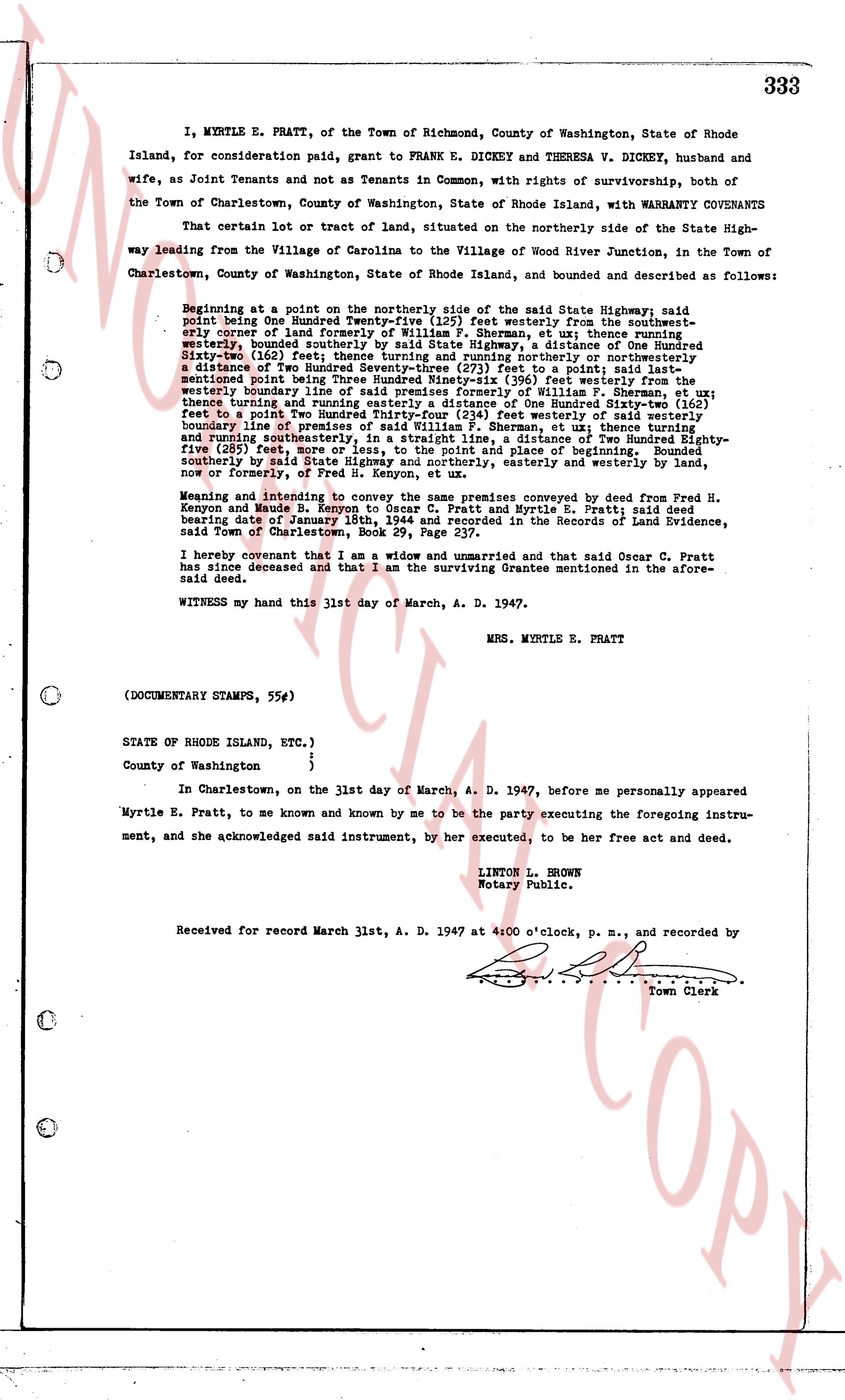
333 I, MYRTLE E. PRATT, of the Town of Richmond, County of Washington, State of Rhode Island, for consideration paid, grant to FRANK E. DICKEY and THERESA V. DICKEY, husband and wife, as Joint Tenants and not as Tenants in Common, with rights of survivorship, both of the Town of Charlestown, County of Washington, State of Rhode Island, with WARRANTY COVENANTS That certain lot or tract of land, situated on the northerly side of the State Highway leading from the Village of Carolina to the Village of Wood River Junction, in the Town of Charlestown, County of Washington, State of Rhode Island, and described as follows: Beginning at a point on the northerly side of the said State Highway, said point being One Hundred Twenty-five (125) feet westerly from the southwesternmost corner of land formerly of Sarah S. [?] , et ux thence northerly One Hundred Twenty-seven (127) feet, southerly bounded by said State Highway, a distance of One Hundred Sixty-one (161) feet, thence easterly One Hundred Twenty-five (125) feet to a point, thence a distance of Two Hundred Seventy-three (273) feet to a point; said land mentioning point being One Hundred Twenty-five (125) feet easterly of the westerly boundary line of said premises formerly of William P. Sherman, et ux; thence turning and running easterly a distance of One Hundred Sixty-two (162) feet to a point, Two Hundred Seventy-three (273) feet northerly of the westerly boundary line of premises of said William P. Sherman, et ux; thence turning and running southeasterly One Hundred Twenty-five (125) feet to a point, Two Hundred Seventy-five (275) feet, more or less, to the point and place of beginning. Bounded on the southerly by said State Highway, a distance of One Hundred Sixty-one (161) feet, westerly and easterly by land, now or formerly, of Fred H. Kenyon, et ux. Meaning and intending to convey the same premises conveyed by deed from Fred H. Kenyon and Maud L. Kenyon et ux to myself and Myrtle E. Pratt; said deed bearing date of January 18th, 1944 and Recorded in the Records of Land Evidence, said Town of Charlestown, Book 29, Page 237. I hereby covenant that I am a widow, unmarried and that said Oscar C. Pratt has since deceased and that I am the surviving Grantee mentioned in the aforesaid deed. WITNESS my hand this 31st day of March, A. D. 1947. MRS. MYRTLE E. PRATT (DOCUMENTARY STAMPS, 55¢) STATE OF RHODE ISLAND, ETC.) ) County of Washington ) In Charlestown, on the 31st day of March, A. D. 1947, before me personally appeared Myrtle E. Pratt, to me known and known by me to be the party executing the foregoing instrument, and she acknowledged said instrument, by her executed, to be her free act and deed. LINTON L. BROWN Notary Public. Received for record March 31, A. D. 1947 at 4:00 o'clock, p. m., and recorded by [Signature] Town Clerk

The page as recorded
page 1

deed_walker_v1.9_2026-10-10 · the index is the town's own (i2l.uslandrecords.com); transcripts, chains and the assessor's cards are the Perry Machine's reading of it. Where the record we hold runs out, the page says so.