The instrument's own words
page 1 · read by Gemma vision
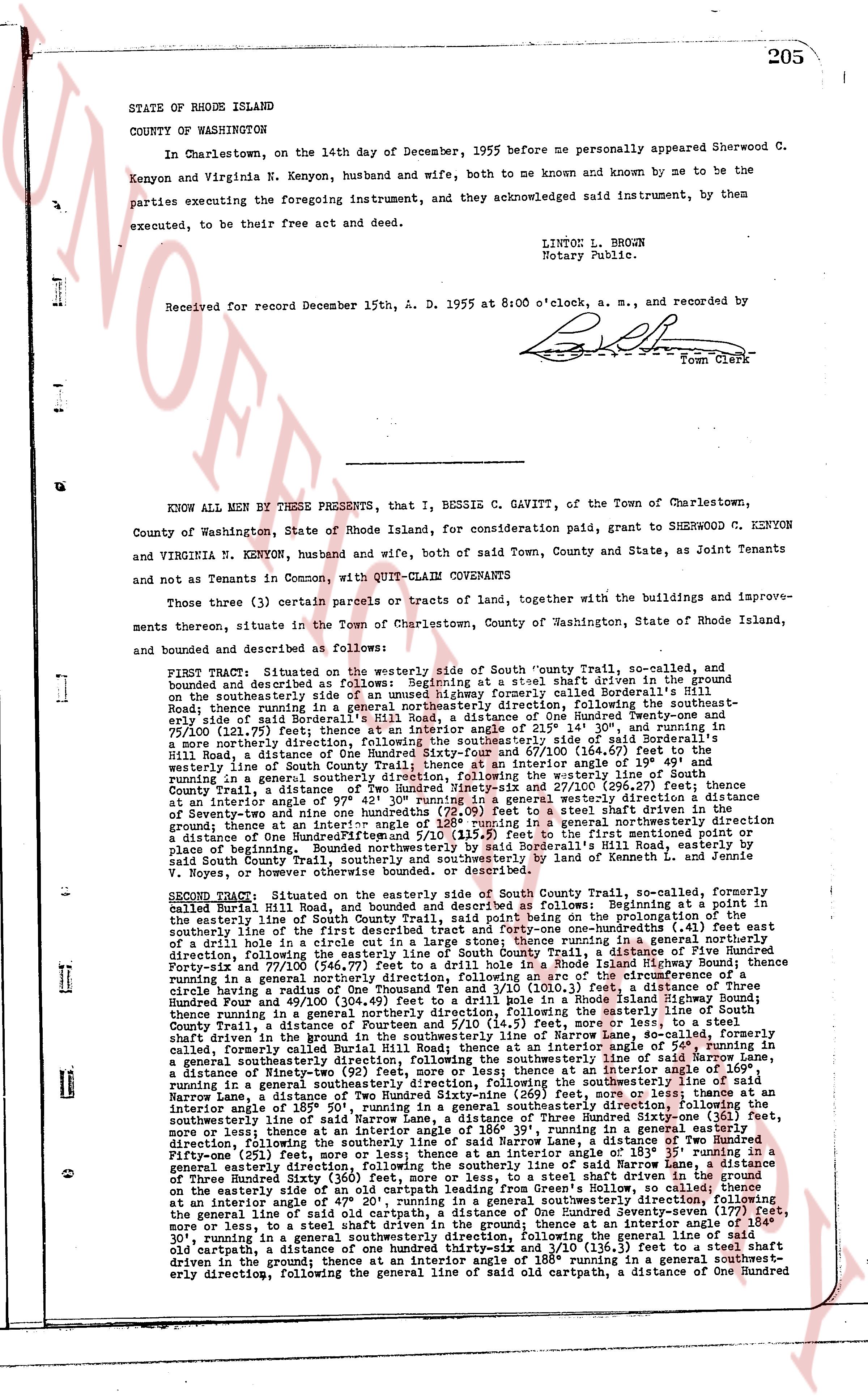
205
STATE OF RHODE ISLAND
COUNTY OF WASHINGTON
In Charlestown, on the 14th day of December, 1955 before me personally appeared Sherwood C. Kenyon and Virginia N. Kenyon, husband and wife, both to me known and known by me to be the parties executing the foregoing instrument, and they acknowledged said instrument, by them executed, to be their free act and deed.
LINTON L. BROWN
Notary Public.
Received for record December 15th, A. D. 1955 at 8:00 o'clock, a. m., and recorded by
[Signature]
Town Clerk
----
KNOW ALL MEN BY THESE PRESENTS, that I, BESSIE C. GAVITT, of the Town of Charlestown, County of Washington, State of Rhode Island, for consideration paid, grant to SHERWOOD C. KENYON and VIRGINIA N. KENYON, husband and wife, both of said Town, County and State, as Joint Tenants and not as Tenants in Common, with QUIT-CLAIM COVENANTS
Those three (3) certain parcels or tracts of land, together with the buildings and improvements thereon, situate in the Town of Charlestown, County of Washington, State of Rhode Island, and bounded and described as follows:
FIRST TRACT: Situated on westerly side of South "county Trail, so-called, and bounded and described as follows: Beginning at a steel shaft driven in the ground on the southeasterly side of an unused highway called Baker's Road, thence running in a southeasterly direction, following the southeasterly side of said Boreal's Hill Road, a distance of One Hundred Twenty-one and 28/100 (121.28) feet; thence running at an interior angle of 110° and 10' and 75/100 (75.75) feet southeasterly; thence running at an interior angle of 135° and 10' in a more northerly direction, following the southeasterly side of said Boreal's Hill Road, a distance of One Hundred Twenty-six and 66/100 (126.66) feet; thence running westerly line of South County Trail, a distance of Two Hundred Ninety-six and 27/100 (296.27) feet; thence at an interior angle of 169° 45' and running in a general easterly direction, following the southeasterly line of South County Trail, a distance of Seven hundred and nine hundredths (709.00) feet to a steel shaft driven in the ground; thence at an interior angle of 115° 30' running in a general northerly direction a distance of One Hundred Twenty-four and 5/100 (124.5) feet to the first mentioned point or place of beginning. Bounded northerly bounded northerly by said Boreal's Hill Road, easterly by said South County Trail, and southerly and westerly by land of Samuel H. Kenyon and Mrs. V. Noyes, or however otherwise bounded or described.
SECOND TRACT: Situated on the easterly side of South County Trail, so-called, formerly called Baker's Hill Road, and bounded and described as follows: Beginning at a point in the easterly line of the South County Trail, said point being on the prolongating of the southeasterly line of said Boreal's Hill Road, a distance of One hundred and 41/100 (100.41) feet to a drill hole in a certain lug in a large stone; thence running in a general northerly direction, following the easterly line of South County Trail, a distance of One Hundred Forty-six and 77/100 (146.77) feet to a drill hole in a Rhode Island highway Bound stone running in a general easterly direction, following the easterly line of South County Trail, a distance of Forty-six and 77/100 (46.77) feet to a drill hole in a Rhode Island highway Bound stone running in a general easterly direction, following the easterly line of South County Trail, circling a radius of One Hundred Ten section 3 and 10/100 (110.3) feet, a distance of Three Hundred Four and 49/100 (304.49) feet in a general northerly direction, following the easterly line of South County Trail, a distance of Fourteen and 5/100 (14.5) feet to a steel shaft driven in the ground; thence running in a general easterly direction, following the easterly line of Narrow Lane, so-called, formerly called Baker's Hill Road, running at an interior angle of 110° and 10' and 75/100 (75.75) feet, to a drill hole in a certain lug in a large stone on the easterly line of said Narrow Lane, a distance of Ninety-two (92) feet, more or less; thence at an interior angle of 169° running in a general southerly direction, following the easterly line of said Narrow Lane, a distance of Ninety-two (92) feet, more or less; thence at an interior angle of 105° running in a general westerly direction, following the southeasterly line of said Narrow Lane, a distance of Two Hundred Sixty-nine (269) feet, more or less; thence at an interior angle of 115° 30' running in a general northerly direction, following the southeasterly line of said Narrow Lane, a distance of Three Hundred Sixty-one (361) feet, more or less; thence at an interior angle of 135° and 10' running in a general easterly direction, following the southeasterly line of said Narrow Lane, a distance of Two Hundred Fifty-three (253) feet, more or less; thence at an interior angle of 110° and 10' running in a general easterly direction, following the southerly line of said Narrow Lane, a distance of Two Hundred Fifty-three (253) feet, more or less; thence at an interior angle of 180° running in a general easterly direction, following the southerly line of said Narrow Lane, a distance of Three Hundred Four and 49/100 (304.49) feet to a steel shaft driven in the ground on the easterly side of an old cartpath leading from Green's Hollow, so called; thence at an interior angle of 45° 20', running in a general southeasterly direction, following the general line of said old cartpath, a distance of One Hundred Seventy-seven (177) feet, more or less, to a steel shaft driven in the ground; thence at an interior angle of 184° 30', running in a general southerly direction, following the general line of said old cartpath, a distance of one hundred thirty-six and 3/10 (136.3) feet to a steel shaft driven in the ground; thence at an interior angle of 135° running in a general westerly direction, following the general line of said old cartpath, a distance of One Hundred
page 2 · read by Gemma vision
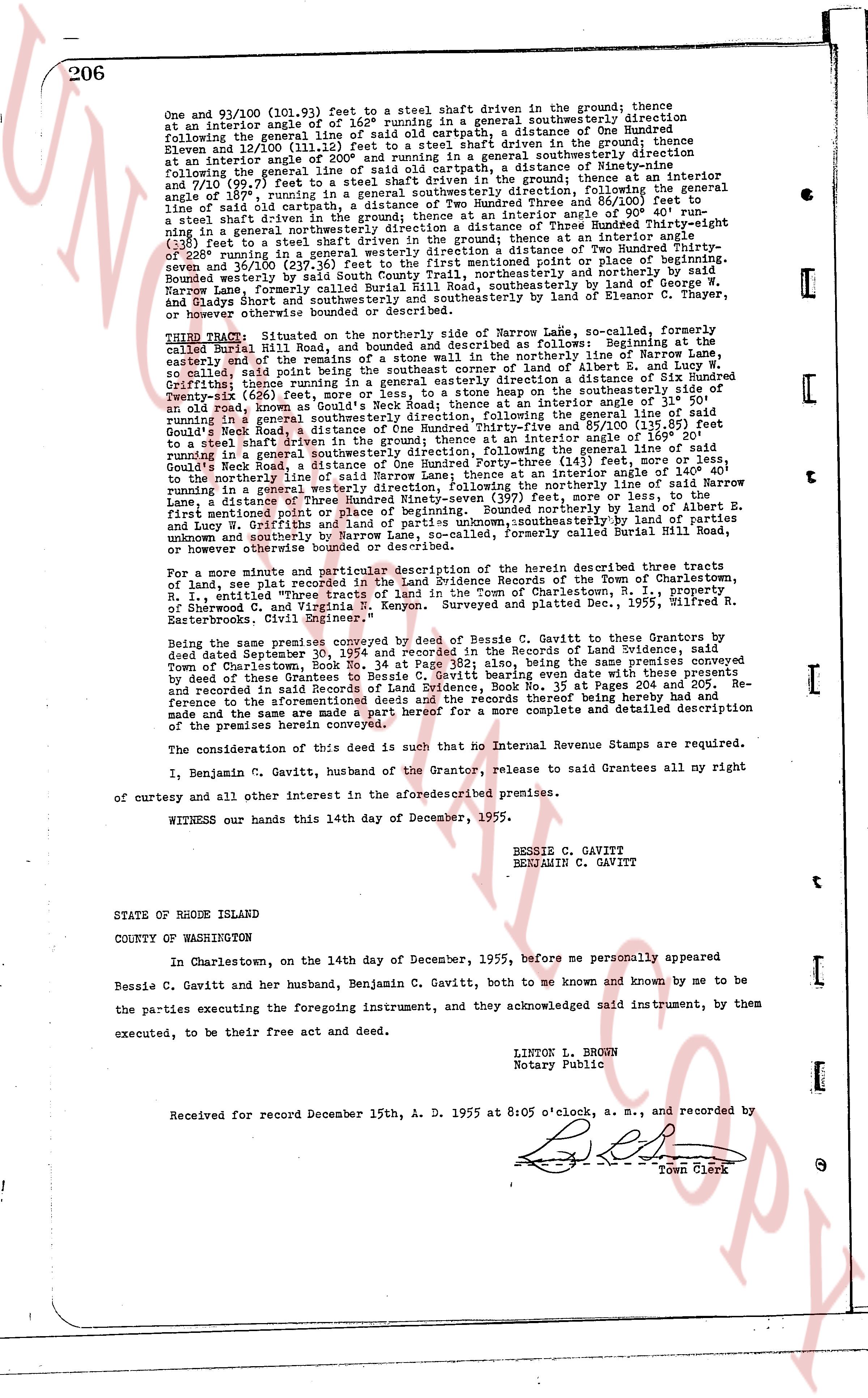
206
One and 93/100 (101.93) feet to a steel shaft driven in the ground; thence at an interior angle of 102° 56' bounding in a general southeasterly direction following the general line of said old cartpath, a distance of One Hundred Twenty seven and 12/100 (127.12) feet to a steel shaft driven in the ground; thence at an interior angle of 90° 14' bounding in a general southwesterly direction following the general line of said old cartpath, a distance of Ninety-nine and 7/10 (99.7) feet to a steel shaft driven in the ground; thence at an interior angle of 90° 14', running in a general southeasterly direction, following the general line of said old cartpath, a distance of Two Hundred Three and 86/100 (203.86) feet to a steel shaft driven in the ground; thence at an interior angle of 90° 40' running in a general northeasterly direction a distance of Three Hundred Twenty eight and 33/100 (328.33) feet to a steel shaft driven in the ground; thence at an interior angle of 228° running in a general westerly direction a distance of Two Hundred Thirty seven and 58/100 (237.58) feet to a steel shaft driven in the ground at point or place of beginning of said Third Parcel. Bounded westerly by South Bound Coast Trail, northeasterly and northerly by Narragansett Lane, formerly known as Old Narragansett Road, easterly by land of E. and Gladys Shorty bounded southeasterly and southerly by boundary of Lane or Southern Cove, or however otherwise bounded or described on the ground.
THIRD PARCEL situated on the northerly side of Narrow Lane, so-called, formerly called Burial Hill Road, bounded and described as follows: Beginning at the easterly end of the boundary of a street so-called, situated north of the Line of the Lane, on said boundary point situated north of corner of land of Albert E. and Lucy W. Griffith; thence running in a general easterly direction a distance of One hundred Twenty-four and 40/100 (124.40) feet to a steel shaft driven in the ground on the southeasterly side of an old road, known as Gould's Neck Road; thence at an interior angle of 113° running in a general southeasterly direction following the general line of said Gould's Neck Road, a distance of One Hundred Twenty-five and 89/100 (125.89) feet to a steel shaft driven in the ground; thence at an interior angle of 113° running in a general southerly direction, following the general line of said Gould's Neck Road, a distance of One Hundred Twenty-one and 13/100 (121.13) feet, to the northerly line of said Narrow Lane; thence at an interior angle of 140° 40' running in a general westerly direction, following the northerly line of Narrow Lane, a distance of Three Hundred Ninety-seven (397) feet, or more or less, to the end of the boundary of a street so-called; thence running in a general northerly direction to the point or place of beginning of this parcel. Bounded easterly by land of Albert E. and Lucy W. Griffith and land of parties unknown, southeasterly by land of parties unknown and southerly by Narrow Lane, so-called, formerly called Burial Hill Road, or however otherwise bounded or described on the ground.
For a more minute and particular description of the herein described three Parcels of land, see plat recorded in the Land Evidence books of the Town of Charlestown, R. I., a certified true copy of which is in the office of Charlestown, R. I., property of Sherwood C. Kenyon and Virginia N. Kenyon. Surveyed and platted Dec. 1955, Wilfred R. Easterbrook, Phil. 311-111-111.
Being the same premises conveyed by deed of Bessie C. Gavitt to these Grantors by deed dated September 30, 1954 and recorded in the Records of Land Evidence, said Town of Charlestown, book 33, page 111. And being the same premises conveyed by deed of Grantees to Bessie C. Gavitt bearing even date with these presents and recorded in said book 35, page 205 of said Records. Reference to the aforementioned deeds and the records thereof being hereby had and made and the same are made a part hereof for a more complete and detailed description of the premises herein conveyed.
The consideration of this deed is such that No Internal Revenue Stamps are required.
I, Benjamin C. Gavitt, husband of the Grantor, release to said Grantees all my right of curtesy and all other interest in the aforesaid premises.
WITNESS our hands this 14th day of December, 1955.
BESSIE C. GAVITT
BENJAMIN C. GAVITT
STATE OF RHODE ISLAND
COUNTY OF WASHINGTON
In Charlestown, on the 14th day of December, 1955, before me personally appeared Bessie C. Gavitt and her husband, Benjamin C. Gavitt, both to me known and known by me to be the parties executing the foregoing instrument, and they acknowledged same instrument, by them executed, to be their free act and deed.
LINTON L. BROWN
Notary Public
Received for record December 15th, A. D. 1955 at 8:05 o'clock, a. m., and recorded by
[Signature]
Town Clerk
The page as recorded