The instrument's own words
page 1 · read by Gemma vision
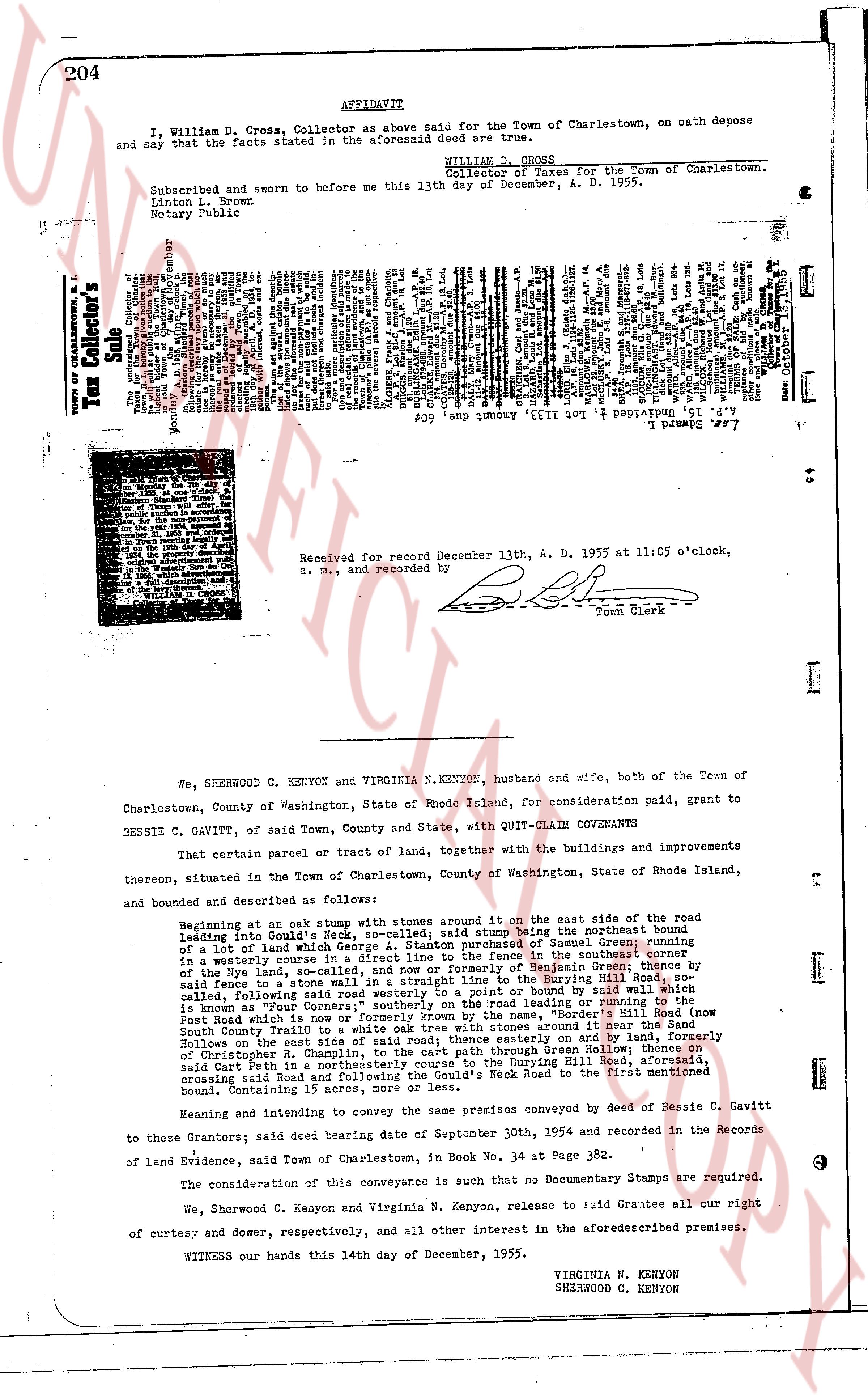
204 AFFIDAVIT
I, William D. Cross, Collector as above said for the Town of Charlestown, on oath depose
and say that the facts stated in the aforesaid deed are true.
WILLIAM D. Cross
Collector of Taxes for the Town of Charlestown.
Subscribed and sworn to before me this 13th day of December, A. D. 1955.
Linton L. Brown
Notary Public
[Upside down text:
Town of Charlestown, R.I.
Tax Collector's
Sale
Notice is hereby given that the following described real estate will be sold by the Collector of Taxes for the Town of Charlestown, R.I. at the Town Hall, Charlestown, R.I. on the 15th day of December, 1955 at 10 o'clock A.M. and whereas taxes are due and unpaid upon the following described real estate, the Collector of Taxes will sell the same to the highest bidder for cash, and the proceeds of such sale will be applied to the payment of the taxes due and unpaid, and the balance, if any, will be paid to the owners of the real estate or their legal representatives.
The real estate to be sold is described as follows:
1. Lot 1, Plat 1, being the land of George A. Sutton, as described in a deed recorded in Land Evidence Book 24, page 112.
2. Lot 2, Plat 1, being the land of George A. Sutton, as described in a deed recorded in Land Evidence Book 24, page 112.
3. Lot 3, Plat 1, being the land of George A. Sutton, as described in a deed recorded in Land Evidence Book 24, page 112.
4. Lot 4, Plat 1, being the land of George A. Sutton, as described in a deed recorded in Land Evidence Book 24, page 112.
5. Lot 5, Plat 1, being the land of George A. Sutton, as described in a deed recorded in Land Evidence Book 24, page 112.
6. Lot 6, Plat 1, being the land of George A. Sutton, as described in a deed recorded in Land Evidence Book 24, page 112.
7. Lot 7, Plat 1, being the land of George A. Sutton, as described in a deed recorded in Land Evidence Book 24, page 112.
8. Lot 8, Plat 1, being the land of George A. Sutton, as described in a deed recorded in Land Evidence Book 24, page 112.
9. Lot 9, Plat 1, being the land of George A. Sutton, as described in a deed recorded in Land Evidence Book 24, page 112.
10. Lot 10, Plat 1, being the land of George A. Sutton, as described in a deed recorded in Land Evidence Book 24, page 112.
11. Lot 11, Plat 1, being the land of George A. Sutton, as described in a deed recorded in Land Evidence Book 24, page 112.
12. Lot 12, Plat 1, being the land of George A. Sutton, as described in a deed recorded in Land Evidence Book 24, page 112.
13. Lot 13, Plat 1, being the land of George A. Sutton, as described in a deed recorded in Land Evidence Book 24, page 112.
14. Lot 14, Plat 1, being the land of George A. Sutton, as described in a deed recorded in Land Evidence Book 24, page 112.
15. Lot 15, Plat 1, being the land of George A. Sutton, as described in a deed recorded in Land Evidence Book 24, page 112.
16. Lot 16, Plat 1, being the land of George A. Sutton, as described in a deed recorded in Land Evidence Book 24, page 112.
17. Lot 17, Plat 1, being the land of George A. Sutton, as described in a deed recorded in Land Evidence Book 24, page 112.
18. Lot 18, Plat 1, being the land of George A. Sutton, as described in a deed recorded in Land Evidence Book 24, page 112.
19. Lot 19, Plat 1, being the land of George A. Sutton, as described in a deed recorded in Land Evidence Book 24, page 112.
20. Lot 20, Plat 1, being the land of George A. Sutton, as described in a deed recorded in Land Evidence Book 24, page 112.
21. Lot 21, Plat 1, being the land of George A. Sutton, as described in a deed recorded in Land Evidence Book 24, page 112.
22. Lot 22, Plat 1, being the land of George A. Sutton, as described in a deed recorded in Land Evidence Book 24, page 112.
23. Lot 23, Plat 1, being the land of George A. Sutton, as described in a deed recorded in Land Evidence Book 24, page 112.
24. Lot 24, Plat 1, being the land of George A. Sutton, as described in a deed recorded in Land Evidence Book 24, page 112.
25. Lot 25, Plat 1, being the land of George A. Sutton, as described in a deed recorded in Land Evidence Book 24, page 112.
26. Lot 26, Plat 1, being the land of George A. Sutton, as described in a deed recorded in Land Evidence Book 24, page 112.
27. Lot 27, Plat 1, being the land of George A. Sutton, as described in a deed recorded in Land Evidence Book 24, page 112.
28. Lot 28, Plat 1, being the land of George A. Sutton, as described in a deed recorded in Land Evidence Book 24, page 112.
29. Lot 29, Plat 1, being the land of George A. Sutton, as described in a deed recorded in Land Evidence Book 24, page 112.
30. Lot 30, Plat 1, being the land of George A. Sutton, as described in a deed recorded in Land Evidence Book 24, page 112.
31. Lot 31, Plat 1, being the land of George A. Sutton, as described in a deed recorded in Land Evidence Book 24, page 112.
32. Lot 32, Plat 1, being the land of George A. Sutton, as described in a deed recorded in Land Evidence Book 24, page 112.
33. Lot 33, Plat 1, being the land of George A. Sutton, as described in a deed recorded in Land Evidence Book 24, page 112.
34. Lot 34, Plat 1, being the land of George A. Sutton, as described in a deed recorded in Land Evidence Book 24, page 112.
35. Lot 35, Plat 1, being the land of George A. Sutton, as described in a deed recorded in Land Evidence Book 24, page 112.
36. Lot 36, Plat 1, being the land of George A. Sutton, as described in a deed recorded in Land Evidence Book 24, page 112.
37. Lot 37, Plat 1, being the land of George A. Sutton, as described in a deed recorded in Land Evidence Book 24, page 112.
38. Lot 38, Plat 1, being the land of George A. Sutton, as described in a deed recorded in Land Evidence Book 24, page 112.
39. Lot 39, Plat 1, being the land of George A. Sutton, as described in a deed recorded in Land Evidence Book 24, page 112.
40. Lot 40, Plat 1, being the land of George A. Sutton, as described in a deed recorded in Land Evidence Book 24, page 112.
41. Lot 41, Plat 1, being the land of George A. Sutton, as described in a deed recorded in Land Evidence Book 24, page 112.
42. Lot 42, Plat 1, being the land of George A. Sutton, as described in a deed recorded in Land Evidence Book 24, page 112.
43. Lot 43, Plat 1, being the land of George A. Sutton, as described in a deed recorded in Land Evidence Book 24, page 112.
44. Lot 44, Plat 1, being the land of George A. Sutton, as described in a deed recorded in Land Evidence Book 24, page 112.
45. Lot 45, Plat 1, being the land of George A. Sutton, as described in a deed recorded in Land Evidence Book 24, page 112.
46. Lot 46, Plat 1, being the land of George A. Sutton, as described in a deed recorded in Land Evidence Book 24, page 112.
47. Lot 47, Plat 1, being the land of George A. Sutton, as described in a deed recorded in Land Evidence Book 24, page 112.
48. Lot 48, Plat 1, being the land of George A. Sutton, as described in a deed recorded in Land Evidence Book 24, page 112.
49. Lot 49, Plat 1, being the land of George A. Sutton, as described in a deed recorded in Land Evidence Book 24, page 112.
50. Lot 50, Plat 1, being the land of George A. Sutton, as described in a deed recorded in Land Evidence Book 24, page 112.
51. Lot 51, Plat 1, being the land of George A. Sutton, as described in a deed recorded in Land Evidence Book 24, page 112.
52. Lot 52, Plat 1, being the land of George A. Sutton, as described in a deed recorded in Land Evidence Book 24, page 112.
53. Lot 53, Plat 1, being the land of George A. Sutton, as described in a deed recorded in Land Evidence Book 24, page 112.
54. Lot 54, Plat 1, being the land of George A. Sutton, as described in a deed recorded in Land Evidence Book 24, page 112.
55. Lot 55, Plat 1, being the land of George A. Sutton, as described in a deed recorded in Land Evidence Book 24, page 112.
56. Lot 56, Plat 1, being the land of George A. Sutton, as described in a deed recorded in Land Evidence Book 24, page 112.
57. Lot 57, Plat 1, being the land of George A. Sutton, as described in a deed recorded in Land Evidence Book 24, page 112.
58. Lot 58, Plat 1, being the land of George A. Sutton, as described in a deed recorded in Land Evidence Book 24, page 112.
59. Lot 59, Plat 1, being the land of George A. Sutton, as described in a deed recorded in Land Evidence Book 24, page 112.
60. Lot 60, Plat 1, being the land of George A. Sutton, as described in a deed recorded in Land Evidence Book 24, page 112.
61. Lot 61, Plat 1, being the land of George A. Sutton, as described in a deed recorded in Land Evidence Book 24, page 112.
62. Lot 62, Plat 1, being the land of George A. Sutton, as described in a deed recorded in Land Evidence Book 24, page 112.
63. Lot 63, Plat 1, being the land of George A. Sutton, as described in a deed recorded in Land Evidence Book 24, page 112.
64. Lot 64, Plat 1, being the land of George A. Sutton, as described in a deed recorded in Land Evidence Book 24, page 112.
65. Lot 65, Plat 1, being the land of George A. Sutton, as described in a deed recorded in Land Evidence Book 24, page 112.
66. Lot 66,
page 2 · read by Gemma vision
STATE OF RHODE ISLAND
COUNTY OF WASHINGTON
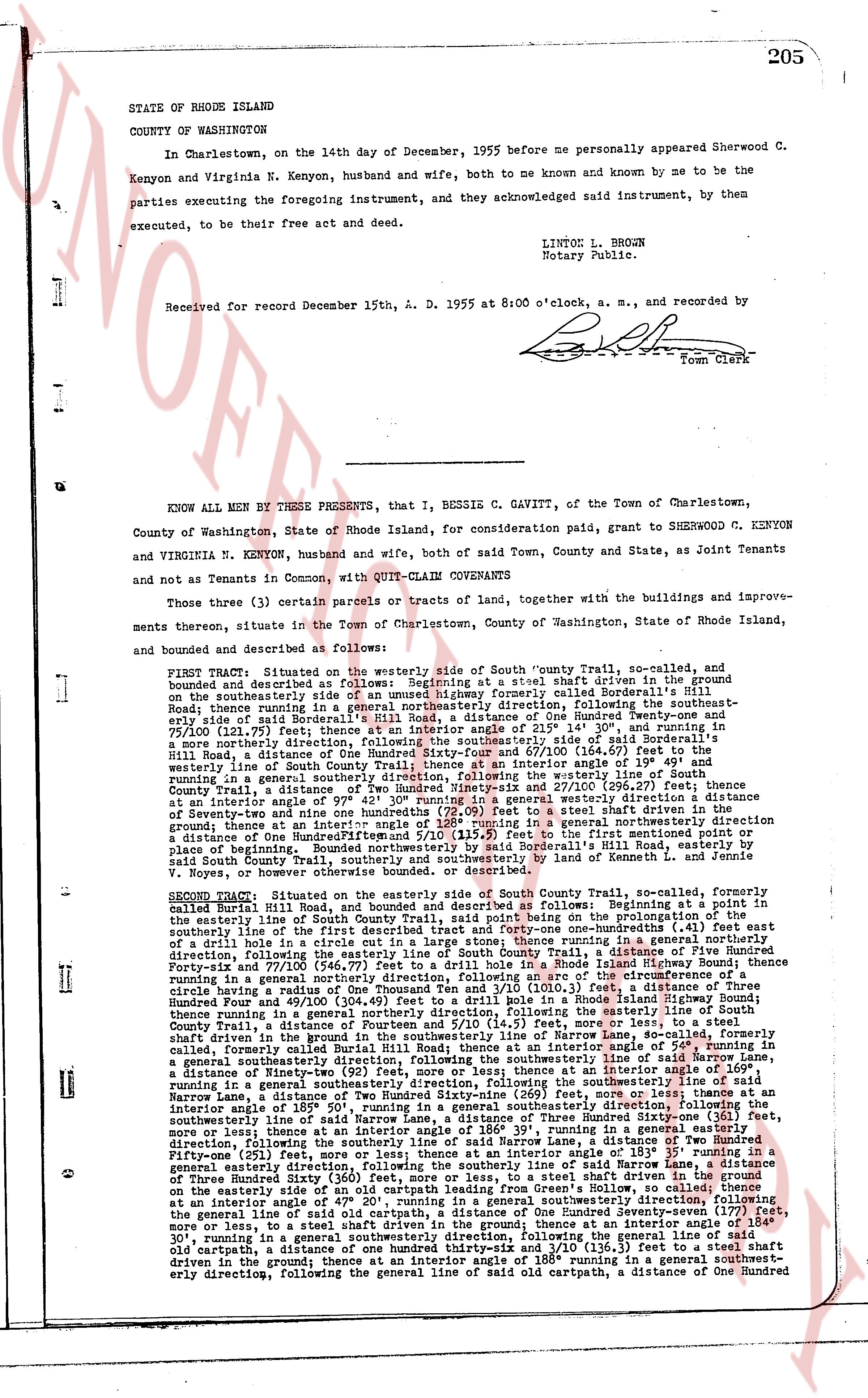
In Charlestown, on the 14th day of December, 1955 before me personally appeared Sherwood C. Kenyon and Virginia N. Kenyon, husband and wife, both to me known and known by me to be the parties executing the foregoing instrument, and they acknowledged said instrument, by them executed, to be their free act and deed.
LINTON L. BROWN
Notary Public.
Received for record December 15th, A. D. 1955 at 8:00 o'clock, a. m., and recorded by [Signature]
Town Clerk
----
KNOW ALL MEN BY THESE PRESENTS, that I, BESSIE C. GAVITT, of the Town of Charlestown, County of Washington, State of Rhode Island, for consideration paid, grant to SHERWOOD C. KENYON and VIRGINIA N. KENYON, husband and wife, both of said Town, County and State, as Joint Tenants and not as Tenants in Common, with QUIT-CLAIM COVENANTS
Those three (3) certain parcels or tracts of land, together with the buildings and improvements thereon, situate in the Town of Charlestown, County of Washington, State of Rhode Island, and bounded and described as follows:
FIRST TRACT: Situated on the westerly side of South County Trail, so called, and bounded and described as follows: Beginning at a steel shaft driven in the ground on the southeasterly side of an unused highway called Baker's Road, thence running in a southeasterly direction, following the southeasterly side of said Bordell's Hill Road, a distance of One Hundred Twenty-one and 75/100 (121.75) feet; thence running at an interior angle of 110° and 10' south by 75/100 (121.75) feet; thence running at an interior angle of 110° and 10' in a more northerly direction, following the southeasterly side of said Bordell's Hill Road, a distance of One Hundred Twenty-one and 75/100 (121.75) feet; thence westerly line of South County Trail, a distance at an interior angle of 169° 49' and running in a general westerly direction, following the southeasterly line of said South County Trail, a distance of Two Hundred Ninety-six and 27/100 (296.27) feet; thence at an interior angle of 110° 11' running in a general southwesterly direction a distance of Seventy-nine and nine hundredths (79.09) feet to a steel shaft driven in the ground; thence at an interior angle of 110° 11' running in a general southeasterly direction a distance of One Hundred Seventy-four and 5/100 (174.05) feet to the first mentioned point or place of beginning. Bounded northerly bounded by said southeasterly side of Bordell's Hill Road, easterly by said South County Trail, southerly by land of Samuel and Mary Elizabeth S. Noyes, or however otherwise bounded or described.
SECOND TRACT: Situated on the easterly side of South County Trail, so called, formerly called Part of Hill Road, bounded and described as follows: Beginning at a point in the easterly line of the South County Trail, said point being on the prolongating of the southeasterly line of the road called Baker's Road, a distance of One Hundred (100) feet easterly of a drill hole cut in a large stone; thence running in a general northerly direction, following the easterly line of South County Trail, a distance of One Hundred Forty-six and 77/100 (146.77) feet to a drill hole in a Rhode Island highway Bound stone running in a general northerly direction, following the easterly line of South County Trail, a distance of One Hundred Forty-six and 77/100 (146.77) feet; thence at an interior angle of 110° 11' running in a general northwesterly direction a radius of One Hundred Ten and 3/100 (110.03) feet, a distance of Three Hundred Four and 49/100 (304.49) feet, thence running at a general northerly direction, following the easterly line of South County Trail, a distance of Fourteen and 5/100 (14.05) feet to a steel shaft driven in the ground; thence at an interior angle of 110° 11' running in a general southeasterly direction to the center line of Narrow Lane, so called, formerly called Part of Hill Road, thence at an interior angle of 110° 11' running in a general southeasterly direction, following the center line of said Narrow Lane, a distance of Ninety-two (92) feet, more or less; thence at an interior angle of 169° 11' running in a general southwesterly direction, following the center line of said Narrow Lane, a distance of Two Hundred Sixty-nine (269) feet, more or less; thence at an interior angle of 110° 11' running in a general northwesterly direction, following the center line of the southeasterly line of said Narrow Lane, a distance of Three Hundred Sixty-one (361) feet, more or less; thence at an interior angle of 110° 11' running in a general northeasterly direction, following the southeasterly line of said Narrow Lane, a distance of Two Hundred Fifty-three (253) feet, more or less; thence at an interior angle of 110° 11' running in a general easterly direction, following the southerly line of said Narrow Lane, a distance of Two Hundred Fifty-three (253) feet, more or less; thence at an interior angle of 110° 11' running in a general easterly direction, following the southerly line of said Narrow Lane, a distance of Three Hundred Sixty-one (361) feet, more or less; thence at an interior angle of 110° 11' running in a general southeasterly direction to a steel shaft driven in the ground on the easterly side of an old cartpath leading from Green's Hollow, so called; thence at an interior angle of 110° 20', running in a general southeasterly direction, following the general line of said old cartpath, a distance of One Hundred Seventy-seven (177) feet, more or less, to a steel shaft driven in the ground; thence at an interior angle of 184° 30', running in a general easterly direction, a distance of One Hundred thirty-six and 3/10 (136.3) feet, to a steel shaft driven in the ground; thence at an interior angle of 110° 11' running in a general northeasterly direction, following the general line of said old cartpath, a distance of One Hundred
The page as recorded