The instrument's own words
page 1 · read by Gemma vision
454
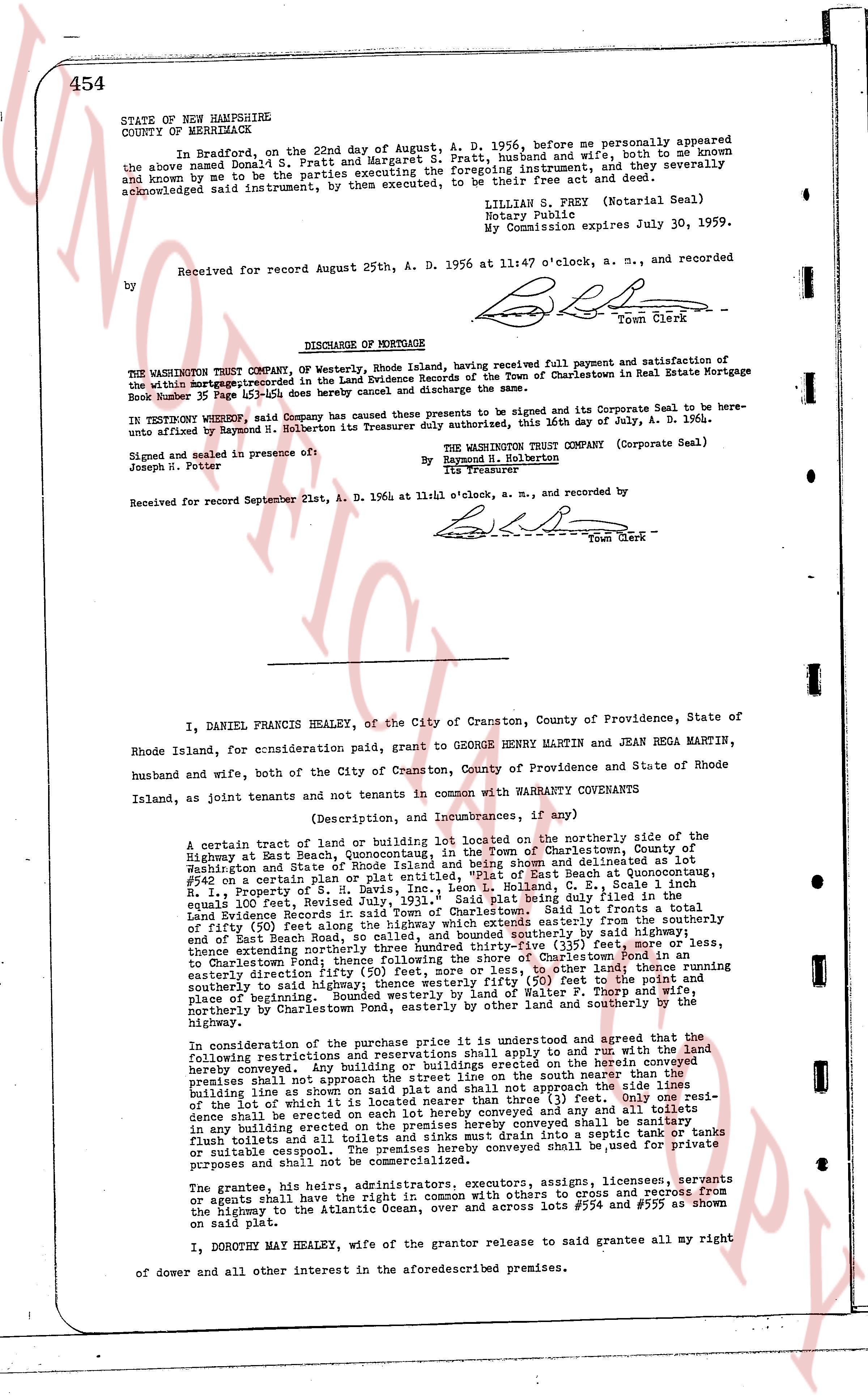
STATE OF NEW HAMPSHIRE
COUNTY OF MERRIMACK
In Bradford, on the 22nd day of August, A. D. 1956, before me personally appeared the above named Donald O. Fratt and Margaret S. Fratt, husband and wife, both to me known and known by me to be the parties executing the foregoing instrument, and they severally and acknowledged said instrument, by them executed, to be their free Act and deed.
LILLIAN S. FREY (Notarial Seal)
Notary Public
My Commission Expires July 30, 1959.
Received for record August 25th, A. D. 1956 at 11:47 o'clock, a. m., and recorded
by [signature]
Town Clerk
----
DISCHARGE OF MORTGAGE
THE WASHINGTON TRUST COMPANY Of Westerly, Rhode Island, having received full payment and satisfaction of the within Mortgage recorded in the Land Evidence books of the Town of Charlestown in Real Estate Mortgage Book 35 page 451-453 as follows here by cancel and discharge the same.
IN TESTIMONY WHEREOF, said Company has caused these presents to be signed and its Corporate Seal to be hereunto affixed by Raymond N. Holberton its Treasurer duly authorized this, 16th day of July, A. D. 1964.
Signed and sealed in presence of:
Joseph N. Potter
THE WASHINGTON TRUST COMPANY (Corporate Seal)
By Raymond N. Holberton
its Treasurer
Received for record September 21st, A. D. 1964 at 11:41 o'clock, a. m., and recorded by [signature]
Town Clerk
----
I, DANIEL FRANCIS HEALEY, of the City of Cranston, County of Providence, State of Rhode Island, for consideration paid, grant to GEORGE HENRY MARTIN and JEAN REGA MARTIN, husband and wife, both of the City of Cranston, County of Providence and State of Rhode Island, as joint tenants and not tenants in common with WARRANTY COVENANTS
(Description, and Incumbrances, if any)
A certain tract of land or building lot located on the northerly side of the Highway at Beat Beach, Quonnoctanicut, in the Town of Charlestown, County of Washington and State of Rhode Island, as it appears and is shown and delimited as lot #542 on a certain plan or plat entitled, "Plat of East Beach at Quonnoctanicut, R. I., Property of L. S. & M. S. Revised July, 1931." Said plat being duly filed in the Land Evidence records of said Town. Said tract of land is bounded as follows: namely on the east by a line of fifty (50) feet along the Highway which extends easterly from the southerly end of East Beach Road, so called, and bounding southerly by said Highway, and then extending northwesterly three hundred thirty-five (335) feet, more or less, thereafter extending northwesterly by said Highway, and then northerly by so other land to Charlestown Pond, following thence the shore of Charlestown Pond, then southerly by so other land to a certain division line between the property of L. S. & M. S. and Walter J. Borg, and then southerly to bounding southerly by said highway thence westerly fifty (50) feet to the point and place of beginning aforesaid. The said lot is bounded namely on the east by the Highway, northerly by Charlestown Pond, easterly by other land and southerly by the Highway.
In consideration of the purchase price it is understood and agreed that the following restrictions and reservations shall apply to and run with the land the herein convey. No lot or building erected on the herein conveyed land and premises shall not approach the street line on the south nearer than the three (3) feet bounding the line shown as a side on the plat and shall not approach the line bounding the lot on the west nearer than three (3) feet. Only one residence shall be erected on each lot herein conveyed except as any and all other buildings in any such building erected on each lot herein conveyed shall be sanitary in any building erected on each lot and toilets and sinks must drain into a septic tank or tanks or suitably encased. The said lot and premises shall be used for private purposes and shall not be commercialized.
The grantee, his heirs, administrators executors, assigns, licensees, servants or agents shall have the right of way in common with others to cross and recross from the Highway to the Atlantic Ocean, over and across lots #554 and #555 as shown on said plat.
I, DOROTHY MAY HEALEY, the wife of the grantor release to said grantee all my right of dower and all other interest in the aforementioned premises.
page 2 · read by Gemma vision
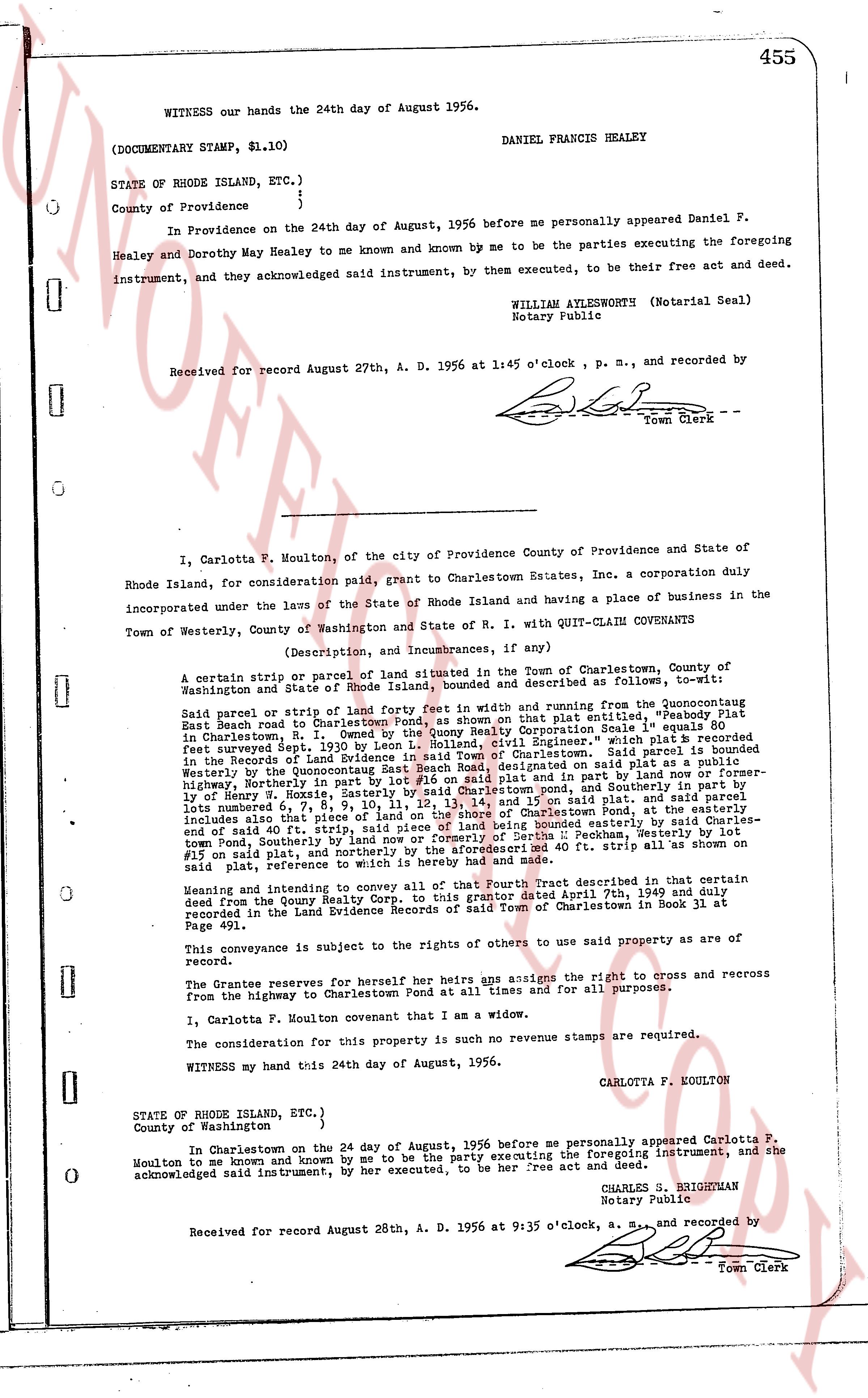
WITNESS our hands the 24th day of August, 1956.
DANIEL FRANCIS HEALEY
(DOCUMENTARY STAMP, $1.10)
STATE OF RHODE ISLAND, ETC.)
)
County of Providence }
In Providence on the 24th day of August, 1956 before me personally appeared Daniel F. Healey and Dorothy May Healey to me known and by me known to be the parties executing the foregoing instrument, and they acknowledged said instrument, by them executed, to be their free act and deed.
WILLIAM AYLESWORTH (Notarial Seal)
Notary Public
Received for record August 27th, A. D. 1956 at 1:45 o'clock, p. m., and recorded by
[Signature]
Town Clerk
----
I, Carlotta F. Moulton, of the city of Providence County of Providence and State of Rhode Island, for consideration paid, grant to Charlestown Estates, Inc. a corporation duly incorporated under the laws of the State of Rhode Island and having a place of business in the Town of Westerly, County of Washington and State of R. I. with QUIT-CLAIM COVENANTS
(Description, and incumbrances, if any)
A certain strip, or parcel of land forming a fee in width and running from the Quonochontoch East Beach road to Charlestown Pond, as shown on the plat entitled, "Weekly Lot 80 in Charlestown, R. I." dated Sept. 1930 by the Charlestown Corp. Scale 1" = 100' which plat is recorded surveyed Aug. 1st, 1930 by Leon L. Holland, civil Engineer," which plat is recorded in the Records of Land Evidence of the Town of Charlestown. Said plat is further described Westerly by the Quonochontoch East Beach Road, designated on said plat as a public highway, Northerly in part by lot 81 and in part by the party grantor, and Southerly in part by lot 80 and in part by the party grantor, and Easterly by the shore of Charlestown Pond, and southerly in part by lot 80 and in part by the party grantor. The land hereby conveyed consists of lots number 6, 7, 8, 9, 10, 11, 12, 13, 14, and 15 on said plat, and the party grantor further includes a plat strip 40 ft. wide, running North and South, along the easterly boundary of Charlestown Pond, easterly by the shore of said pond, Northerly by lot 1, Westerly by lot 15 on said plat, and northerly by the aforesaid 40 ft. strip all as shown on said plat, reference to write more.
Meaning and intending to convey all of that Fourth Tract described in that certain deed from the Quony Realty Corp. to this grantor dated April 7th, 1949 and duly recorded in the Land Evidence Records of said Town of Charlestown in Book 31 at Page 39.
This conveyance is subject to the rights of others to use said property as a way of record.
The Grantor reserves for herself her heirs assigns the right to cross and access from the highway to Charlestown Pond at all times and for all purposes.
I, Carlotta F. Moulton covenant that I am a widow.
The consideration for this property is such no revenue stamps are required.
WITNESS my hand this 24th day of August, 1956.
CARLOTTA F. KOULTON
STATE OF RHODE ISLAND, ETC.)
)
County of Washington }
In Charlestown on the 24 day of August, 1956 before me personally appeared Carlotta F. Moulton to me known and by me known and by me, to be the party executing the foregoing instrument, and acknowledged said instrument, by her executed, to be her free act and deed.
CHARLES S. BRIGHAMAN
Notary Public
Received for record August 28th, A. D. 1956 at 9:35 o'clock, a. m., and recorded by
[Signature]
Town Clerk
The page as recorded