The instrument's own words
page 1 · read by Gemma vision
357
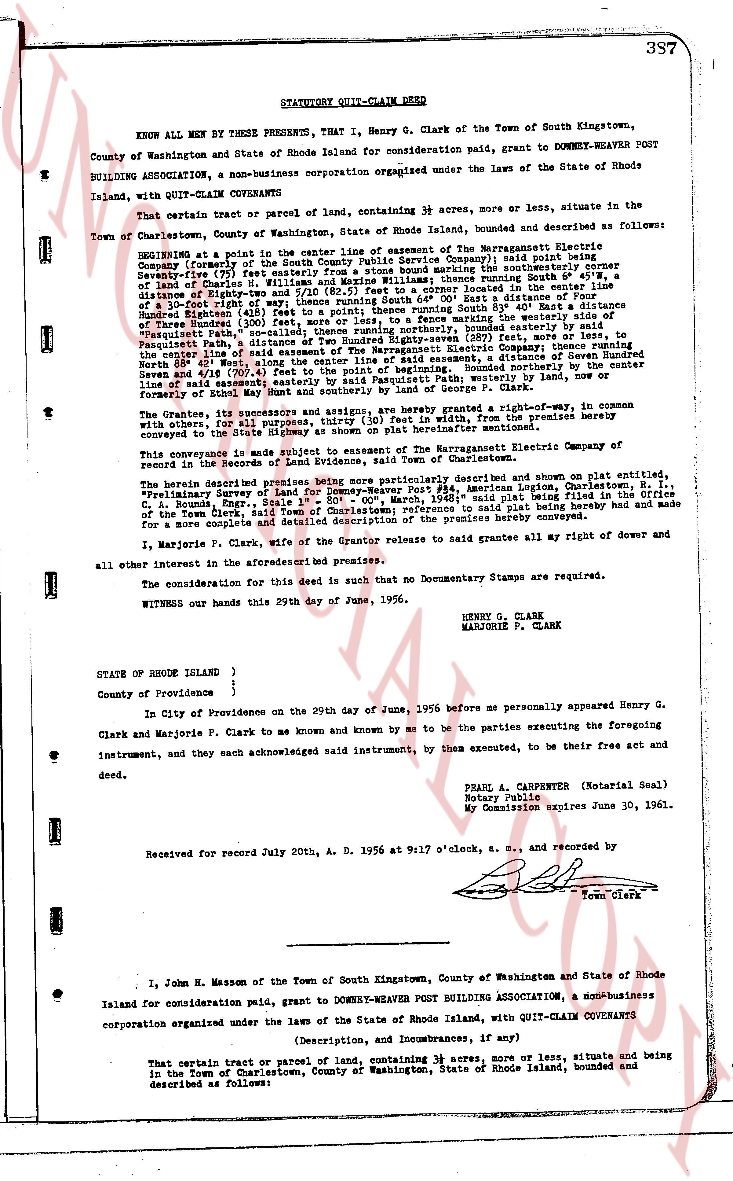
STATUTORY QUIT-CLAIM DEED
KNOW ALL MEN BY THESE PRESENTS, That I, Henry G. Clark of the Town of South Kingstown, County of Washington and State of Rhode Island for consideration paid, grant to DOWNEY-WEAVER POST BUILDING ASSOCIATION, a non-business corporation organized under the laws of the State of Rhode Island, with QUIT-CLAIM COVENANTS
That certain tract or parcel of land, containing 3 acres, more or less, situate in the Town of Charlestown, County of Washington, State of Rhode Island, bounded and described as follows:
BEGINNING at a point in the center line of easement of the Narragansett Electric Company (formerly the Rhode Island State Electric Company) said point being Seventy-five (75) feet easterly from a stone fence marking the southeasterly corner of a lot of lands of Dwight-Yoe and fifty (50) feet south of the center line of a distance of Eighty-two (82) and fifty (5/10) feet s.e. from a corner located in the center line of said easement of the Narragansett Electric Company; thence East a distance of three-hundred (300) feet right of way; thence turning South 61° East a distance of Three Hundred Eighty (380) feet; thence turning South 61° East a distance of Three Hundred (300) feet; thence turning southerly, bounded easterly by said Pasquitts Path, a distance of Two Hundred Eighty (280) feet; thence turning North 88° 42' West, along the center line of said easement of the Narragansett Electric Company, thence turning North 88° 42' West along the center line of said easement, a distance of Three Hundred (300) feet; thence turning North 61° West a distance of Three Hundred Eighty (380) feet, bounded northerly by the center line of said easement; said by Pasquitts Path; westerly by land, now or formerly of Ezra h. [?] and Ezra h. [?] and Ezra h. Clark.
The Grantees and its successors and assigns, are hereby granted a right-of-way, in common with others, for all purposes, thirty (30) feet in width, from the premises hereby conveyed to the State Highway 138 [?] 313 [?] [?] [?] [?] [?] [?] [?] [?] [?] [?] [?] [?] [?] [?] [?] [?] [?] [?] [?] [?] [?] [?] [?] [?] [?] [?] [?] [?] [?] [?] [?] [?] [?] [?] [?] [?] [?] [?] [?] [?] [?] [?] [?] [?] [?] [?] [?] [?] [?] [?] [?] [?] [?] [?] [?] [?] [?] [?] [?] [?] [?] [?] [?] [?] [?] [?] [?] [?] [?] [?] [?] [?] [?] [?] [?] [?] [?] [?] [?] [?] [?] [?] [?] [?] [?] [?] [?] [?] [?] [?] [?] [?] [?] [?] [?] [?] [?] [?] [?] [?] [?] [?] [?] [?] [?] [?] [?] [?] [?] [?] [?] [?] [?] [?] [?] [?] [?] [?] [?] [?] [?] [?] [?] [?] [?] [?] [?] [?] [?] [?] [?] [?] [?] [?] [?] [?] [?] [?] [?] [?] [?] [?] [?] [?] [?] [?] [?] [?] [?] [?] [?] [?] [?] [?] [?] [?] [?] [?] [?] [?] [?] [?] [?] [?] [?] [?] [?] [?] [?] [?] [?] [?] [?] [?] [?] [?] [?] [?] [?] [?] [?] [?] [?] [?] [?] [?] [?] [?] [?] [?] [?] [?] [?] [?] [?] [?] [?] [?] [?] [?] [?] [?] [?] [?] [?] [?] [?] [?] [?] [?] [?] [?] [?] [?] [?] [?] [?] [?] [?] [?] [?] [?] [?] [?] [?] [?] [?] [?] [?] [?] [?] [?] [?] [?] [?] [?] [?] [?] [?] [?] [?] [?] [?] [?] [?] [?] [?] [?] [?] [?] [?] [?] [?] [?] [?] [?] [?] [?] [?] [?] [?] [?] [?] [?] [?] [?] [?] [?] [?] [?] [?] [?] [?] [?] [?] [?] [?] [?] [?] [?] [?] [?] [?] [?] [?] [?] [?] [?] [?] [?] [?] [?] [?] [?] [?] [?] [?] [?] [?] [?] [?] [?] [?] [?] [?] [?] [?] [?] [?] [?] [?] [?] [?] [?] [?] [?] [?] [?] [?] [?] [?] [?] [?] [?] [?] [?] [?] [?] [?] [?] [?] [?] [?] [?] [?] [?] [?] [?] [?] [?] [?] [?] [?] [?] [?] [?] [?] [?] [?] [?] [?] [?] [?] [?] [?] [?] [?] [?] [?] [?] [?] [?] [?] [?] [?] [?] [?] [?] [?] [?] [?] [?] [?] [?] [?] [?] [?] [?] [?] [?] [?] [?] [?] [?] [?] [?] [?] [?] [?] [?] [?] [?] [?] [?] [?] [?] [?] [?] [?] [?] [?] [?] [?] [?] [?] [?] [?] [?] [?] [?] [?] [?] [?] [?] [?] [?] [?] [?] [?] [?] [?] [?] [?] [?] [?] [?] [?] [?] [?] [?] [?] [?] [?] [?] [?] [?] [?] [?] [?] [?] [?] [?] [?] [?] [?] [?] [?] [?] [?] [?] [?] [?] [?] [?] [?] [?] [?] [?] [?] [?] [?] [?] [?] [?] [?] [?] [?] [?] [?] [?] [?] [?] [?] [?] [?] [?] [?] [?] [?] [?] [?] [?] [?] [?] [?] [?] [?] [?] [?] [?] [?] [?] [?] [?] [?] [?] [?] [?] [?] [?] [?] [?] [?] [?] [?] [?] [?] [?] [?] [?] [?] [?] [?] [?] [?] [?] [?] [?] [?] [?] [?] [?] [?] [?] [?] [?] [?] [?] [?] [?] [?] [?] [?] [?] [?] [?] [?] [?] [?] [?] [?] [?] [?] [?] [?] [?] [?] [?] [?] [?] [?] [?] [?] [?] [?] [?] [?] [?] [?] [?] [?] [?] [?] [?] [?] [?] [?] [?] [?] [?] [?] [?] [?] [?] [?] [?] [?] [?] [?] [?] [?] [?] [?] [?] [?] [?] [?] [?] [?] [?] [?] [?] [?] [?] [?] [?] [?] [?] [?] [?] [?] [?] [?] [?] [?] [?] [?] [?] [?] [?] [?] [?] [?] [?] [?] [?] [?] [?] [?] [?] [?] [?] [?] [?] [?] [?] [?] [?] [?] [?] [?] [?] [?] [?] [?] [?] [?] [?] [?] [?] [?] [?] [?] [?] [?] [?] [?] [?] [?] [?] [?] [?] [?] [?] [?] [?] [?] [?] [?] [?] [?] [?] [?] [?] [?] [?] [?] [?] [?] [?] [?] [?] [?] [?] [?] [?] [?] [?] [?] [?] [?] [?] [?] [?] [?] [?] [?] [?] [?] [?] [?] [?] [?] [?] [?] [?] [?] [?] [?] [?] [?] [?] [?] [?] [?] [?] [?] [?] [?] [?] [?] [?] [?] [?] [?] [?] [?] [?] [?] [?] [?] [?] [?] [?] [?] [?] [?] [?] [?] [?] [?] [?] [?] [?] [?] [?] [?] [?] [?] [?] [?] [?] [?] [?] [?] [?] [?] [?] [?] [?] [?] [?] [?] [?] [?] [?] [?] [?] [?] [?] [?] [?] [?] [?] [?] [?] [?] [?] [?] [?] [?] [?] [?] [?] [?] [?] [?] [?] [?] [?] [?] [?] [?] [?] [?] [?] [?] [?] [?] [?] [?] [?] [?] [?] [?] [?] [?] [?] [?] [?] [?] [?] [?] [?] [?] [?] [?] [?] [?] [?] [?] [?] [?] [?] [?] [?] [?] [?] [?] [?] [?] [?] [?] [?] [?] [?] [?] [?] [?] [?] [?] [?] [?] [?] [?] [?] [?] [?] [?] [?] [?] [?] [?] [?] [?] [?] [?] [?] [?] [?] [?] [?] [?] [?] [?] [?] [?] [?] [?] [?] [?] [?] [?] [?] [?] [?] [?] [?] [?] [?] [?] [?] [?] [?] [?] [?] [?] [?] [?] [?] [?] [?] [?] [?] [?] [?] [?] [?] [?] [?] [?] [?] [?] [?] [?] [?] [?] [?] [?] [?] [?] [?] [?] [?] [?] [?] [?] [?] [?] [?] [?] [?] [?] [?] [?] [?] [?] [?] [?] [?] [?] [?] [?] [?] [?] [?] [?] [?] [?] [?] [?] [?] [?] [?] [?] [?] [?] [?] [?] [?] [?] [?] [?] [?] [?] [?] [?] [?] [?] [?] [?] [?] [?] [?] [?] [?] [?] [?] [?] [?] [?] [?] [?] [?] [?] [?] [?] [?] [?] [?] [?] [?] [?] [?] [?] [?] [?] [?] [?] [?] [?] [?] [?] [?] [?] [?] [?] [?] [?] [?] [?] [?] [?] [?] [?] [?] [?] [?] [?] [?] [?] [?] [?] [?] [?] [?] [?] [?] [?] [?] [?] [?] [?] [?] [?] [?] [?] [?] [?] [?] [?] [?] [?] [?] [?] [?] [?] [?] [?] [?] [?] [?] [?] [?] [?] [?] [?] [?] [?] [?] [?] [?] [?] [?] [?] [?] [?] [?] [?] [?] [?] [?] [?] [?] [?] [?] [?] [?] [?] [?] [?] [?] [?] [?] [?] [?] [?] [?] [?] [?] [?] [?] [?] [?] [?] [?] [?] [?] [?] [?] [?] [?] [?] [?] [?] [?] [?] [?] [?] [?] [?] [?] [?] [?] [?] [?] [?] [?] [?] [?] [?] [?] [?] [?] [?] [?] [?] [?] [?] [?] [?] [?] [?] [?] [?] [?] [?] [?] [?] [?] [?] [?] [?] [?] [?] [?] [?] [?] [?] [?] [?] [?] [?] [?] [?] [?] [?] [?] [?] [?] [?] [?] [?] [?] [?] [?] [?] [?] [?] [?] [?] [?] [?] [?] [?] [?] [?] [?] [?] [?] [?] [?] [?] [?] [?] [?] [?] [?] [?] [?] [?] [?] [?] [?] [?] [?] [?] [?] [?] [?] [?] [?] [?] [?] [?] [?] [?] [?] [?] [?] [?] [?] [?] [?] [?] [?] [?] [?] [?] [?] [?] [?] [?] [?] [?] [?] [?] [?] [?] [?] [?] [?] [?] [?] [?] [?] [?] [?] [?] [?] [?] [?] [?] [?] [?] [?] [?] [?] [?] [?] [?] [?] [?] [?] [?] [?] [?] [?] [?] [?] [?] [?] [?]
page 2 · read by Gemma vision
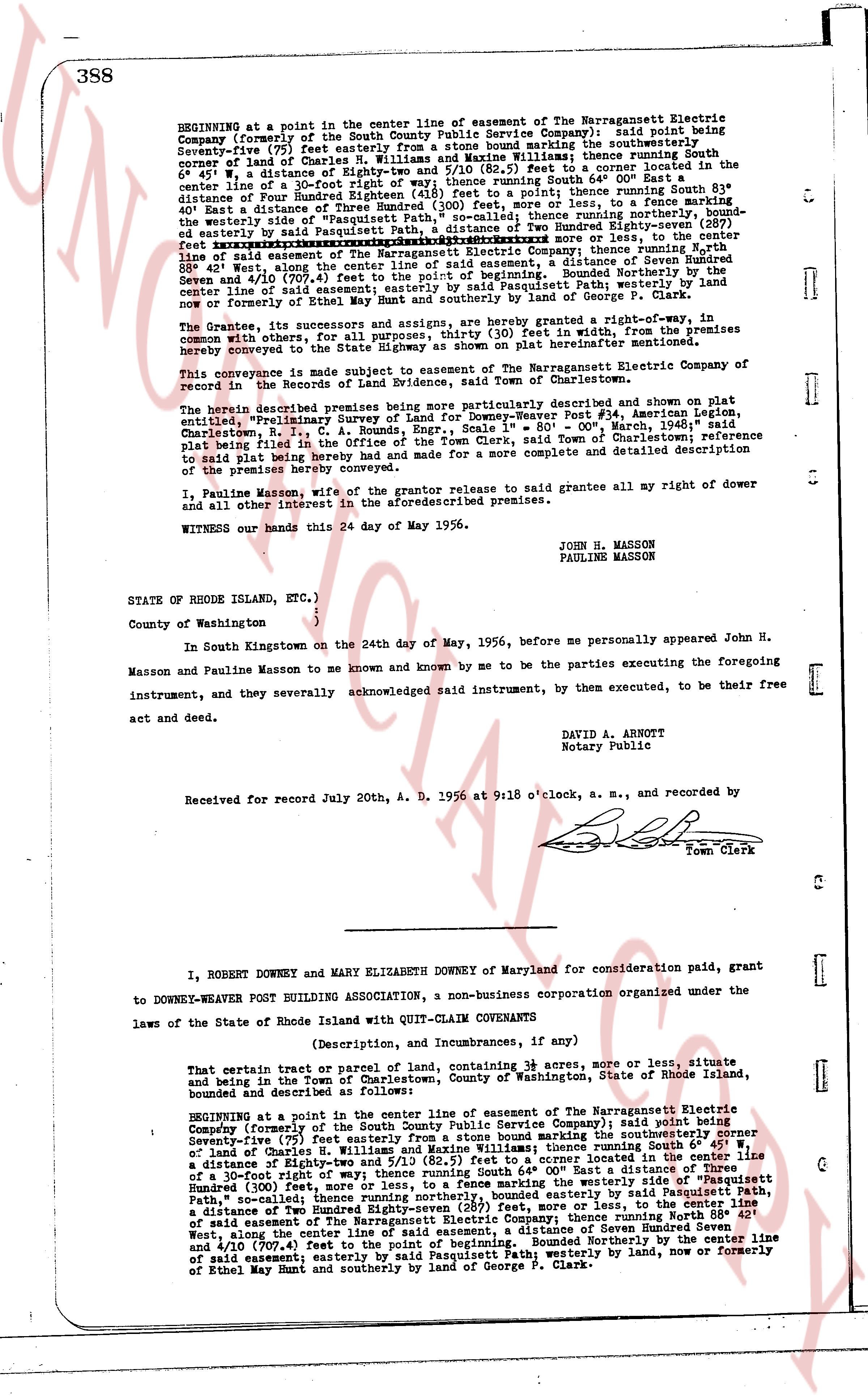
BEGINNING at a point in the center line of easement of The Narragansett Electric Company (formerly of the South County Public Service Company); said point being Seventy-five (75) feet easterly from a stone bound marking the southwesterly corner of land of Charles R. Williams and Mary Williams lifetime spouse running South 6° 45' W. a distance of Eighty-two and 5/10 (82.5) feet to a corner located in the center line of a 30-foot right-of-way; thence running South 83° 00' East a distance of four Hundred (400) feet to a point; thence running South 83° 00' East a distance of Three Hundred (300) feet, more or less, to a fence marking the westerly side of an existing right-of-way; thence running northerly, bounded easterly by said Pasquitt Path, a distance of Two Hundred Eighty-seven (287) feet, more or less, to the center line of said easement of The Narragansett Electric Company; thence running north 83° 00' West, along the center line of said easement, a distance of Three Hundred Eighty-four (384) feet along the center line of said easement, a distance of Seven Hundred Seven and 4/10 (707.4) feet to the point of beginning. Bounded Northerly by the center line of a 30-foot right-of-way; bounded easterly by the westerly line, now or formerly of Ethel May Hunt and southerly by land of George P. Clark.
The Grantee, its successors and assigns, are hereby granted right-of-way, in common with others, for all purposes, 30 feet in width, from the premises hereby conveyed to the center line of the Highway as shown on plat hereinafter mentioned.
This conveyance is made subject to easement of The Narragansett Electric Company of record in the Records of Land Evidence, said Town of Charlestown.
The herein described premises being more particularly described and shown on plat entitled "Preliminary Survey of Lot 4, Block 1, and Parcel #14, Ferguson Addition, Charlestown, R.I., C. A. Bounds, Engrs., Scale 1" = 80', March 1956, reference plat being filed in the land evidence records of the Town of Charlestown; reference to said plat being hereby had and made for a more complete and detailed description of the premises hereby conveyed.
I, Pauline Masson, wife of the grantor release to said grantee all my right of dower and all other interest in the aforementioned premises.
WITNESSED this 24 day of May 1956.
JOHN H. MASSON
PAULINE MASSON
STATE OF RHODE ISLAND, ETC.)
County of Washington. )
In South Kingstown on the 24th day of May, 1956, before me personally appeared John H. Masson and Pauline Masson to me known and known by me to be the parties executing the foregoing instrument, and they severally acknowledged said instrument, by them executed, to be their free act and deed.
DAVID A. ARNOLD
Notary Public
Received for record July 20th, A. D. 1956 at 9:18 o'clock, a. m., and recorded by
[Signature]
Town Clerk
----
I, ROBERT DOWNEY and MARY ELIZABETH DOWNEY of Maryland for consideration paid, grant to DOWNEY-WEAVER POST BUILDING ASSOCIATION, a non-business corporation organized under the laws of the State of Rhode Island with QUIT-CLAIM COVENANTS
(Description, and Incumbrances, if any)
That certain tract or parcel of land, containing 38 acres, more or less, situate and being in the Town of Charlestown, County of Washington, State of Rhode Island, bounded and described as follows:
BEGINNING at a point in the center line of easement of The Narragansett Electric Company (formerly of the South County Public Service Company); said point being Seventy-five (75) feet easterly from a stone bound marking the southwesterly corner of land of Charles R. Williams and Mary Williams lifetime spouse running South 6° 45' W. a distance of Eighty-two and 5/10 (82.5) feet to a corner located in the center line of a 30-foot right-of-way; thence running South 83° 00' East a distance of Three Hundred (300) feet, more or less, to a fence marking the westerly side of an existing right-of-way; thence running northerly, bounded easterly by said Pasquitt Path, a distance of Two Hundred Eighty-seven (287) feet, more or less, to the center line of said easement of The Narragansett Electric Company; thence running north 83° 00' West, along the center line of said easement, a distance of Seven Hundred Seven and 4/10 (707.4) feet to the point of beginning. Bounded Northerly by the center line of said easement; easterly by said Pasquitt Path; westerly by land, now or formerly of Ethel May Hunt and southerly by land of George P. Clark.
The page as recorded