The instrument's own words
page 1 · read by Gemma vision
65
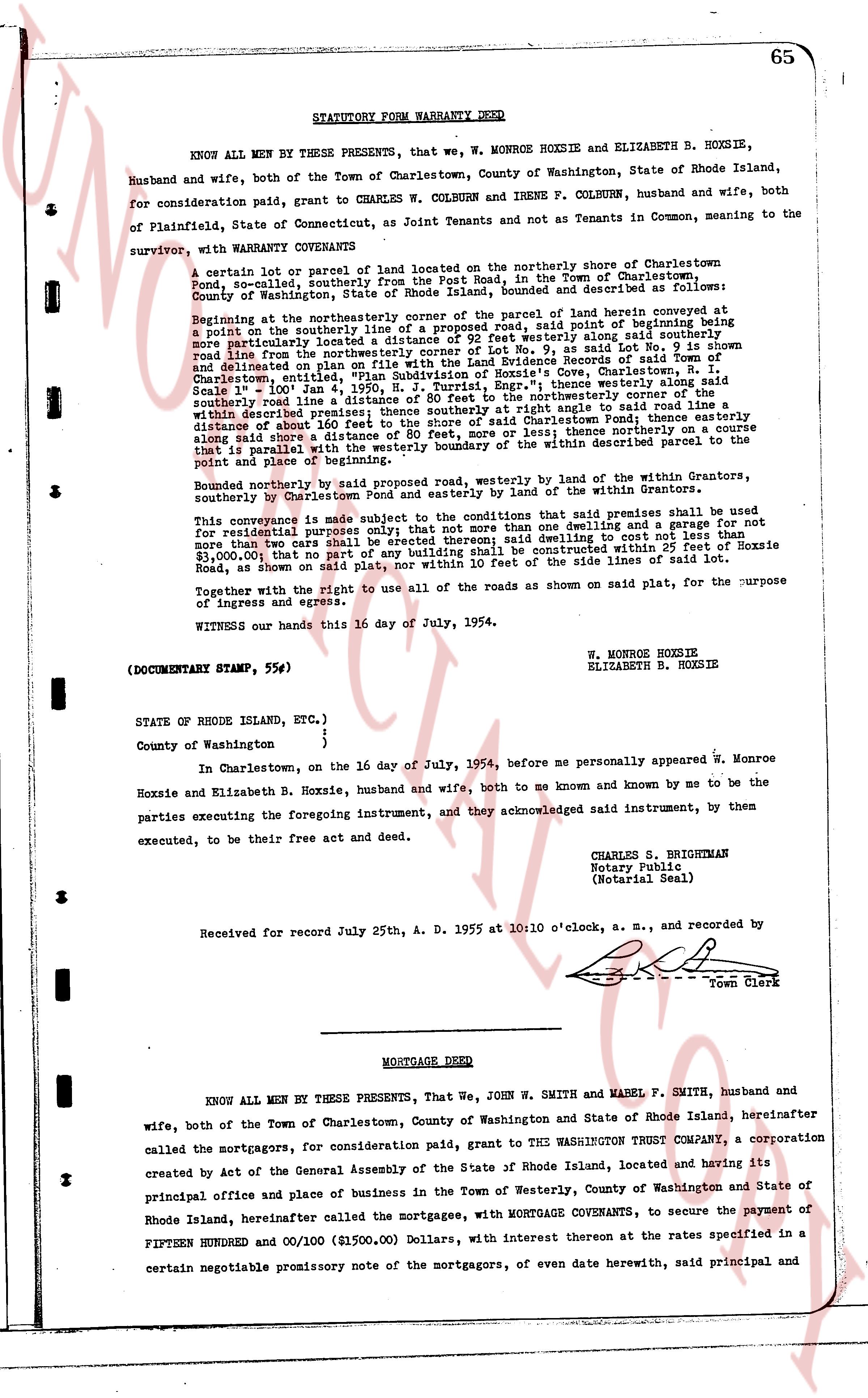
STATUTORY FORM WARRANTY DEED
KNOW ALL MEN BY THESE PRESENTS, that we, W. MONROE HOXSIE and ELIZABETH B. HOXSIE, husband and wife, both of the Town of Charlestown, County of Washington, State of Rhode Island, for consideration paid, grant to CHARLES W. COLBURN and IRENE F. COLBURN, husband and wife, both of Plainfield, State of Connecticut, as Joint Tenants and not as Tenants in Common, meaning to the survivor, with WARRANTY COVENANTS
A certain lot or parcel of land located on the northerly shore of Charlestown Pond, situated southerly from the Post Road, in the Town of Charlestown, County of Washington, State of Rhode Island, bounded and described as follows: Beginning at the northeasterly corner of the parcel of land herein conveyed the point of beginning be a point on the southerly line of the aforementioned road, said point of beginning being more particularly located a distance of 92 feet westerly along said Lot No. 9 is shown delineated from the center line of the road, 0.9 mi. S. as laid out in the Land Evidence Records of said Town of Charlestown, entitled "State of Rhode Island, County of Washington, Town of Charlestown, [?] 1945, N. J. Turrisi, Engr."; thence easterly along said road Scale 1" = 100' Jan 4 1950, N. J. Turrisi, Engr."; thence easterly along said road southerly line a distance of 100 feet, more or less; thence northerly connected to the point which is within described premises; thence southerly at right angle to said road line a distance of about 100 feet, more or less, to the easterly shore of Charlestown Pond, thence easterly along shore a distance of 80 feet, more or less; thence northerly on a course that is parallel with the westerly boundary of the within described parcel to the point of beginning of the within described premises.
Bounded northerly by said reserved road, westerly by the land of the Within Grantors, southerly by Charlestown Pond and easterly by land of the Within Grantees.
This conveyance is made subject to the conditions that the said grant of land shall be used for residential purposes only, for the erection of one dwelling and a garage for not more than two cars shall be erected thereon; said dwelling to cost not less than $5,000.00, and no building shall be erected thereon within 25 feet of Hoxsie Road, as shown on said plat, nor within 10 feet of the side lines of said lot.
Together with the right to use all of the roads as shown on said plat, for the purpose of ingress and egress.
WITNESS our hands this 16 day of July, 1954.
W. MONROE HOXSIE
ELIZABETH B. HOXSIE
(DOCUMENTARY STAMP, 55¢)
STATE of Rhode Island, ETC.
}
}
County of Washington
}
In Charlestown, on the 16 day of July, 1954, before me personally appeared w. Monroe Hoxsie and Elizabeth B. Hoxsie, husband and wife, both to me known and known by me to be the parties executing the foregoing instrument, and they acknowledged said instrument, by them executed, to be their free act and deed.
CHARLES S. BRIGHTMAN
Notary Public
(Notarial Seal)
Received for record July 25th A. D. 1955 at 10:10 o'clock, a. m., and recorded by
[Signature]
Town Clerk
----
MORTGAGE DEED
KNOW ALL MEN BY THESE PRESENTS, That we, John W. SMITH and MABEL F. SMITH, husband and wife, both of the Town of Charlestown, County of Washington and State of Rhode Island, hereinafter called the mortgagors, for consideration paid, grant to THE WASHINGTON TRUST COMPANY, a corporation created by act of the General Assembly of the State of Rhode Island, located and having its principal office and place of business in the Town of Westerly, County of Washington and State of Rhode Island, hereinafter called the mortgagee, with MORTGAGE COVENANTS, to secure the payment of FIFTEEN HUNDRED and 00/100 ($1500.00) Dollars, with interest thereon at the rates specified in a certain negotiable promissory note of the mortgagors, of even date herewith, said principal and
page 2 · read by Gemma vision
66
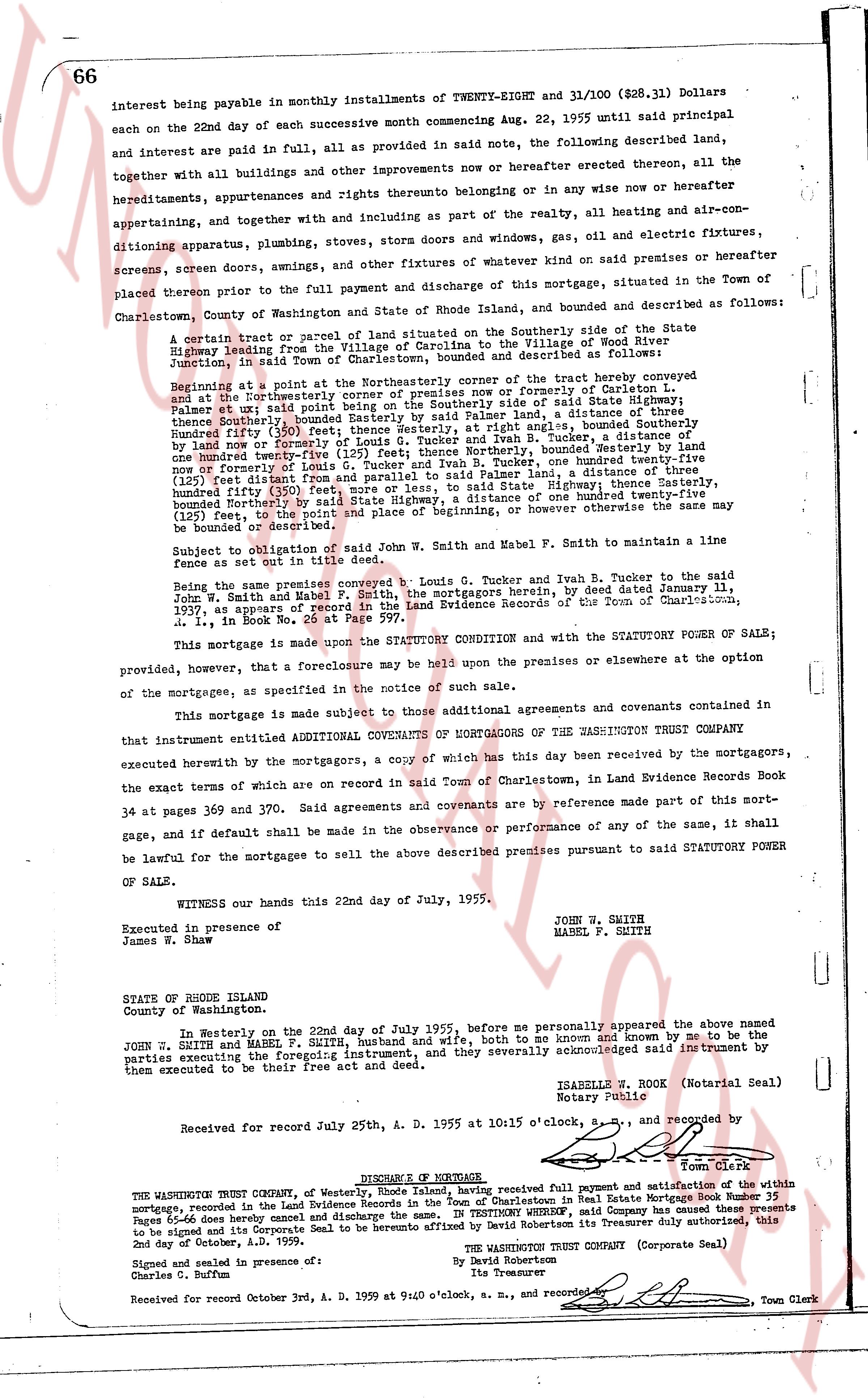
interest being payable in monthly installments of TWENTY-EIGHT and 31/100 ($28.31) Dollars each on the 22nd day of each successive month commencing Aug. 22, 1955 until said principal and interest are paid in full, all provided as in said note, the following described land, together with all buildings and other improvements now or hereafter erected thereon, all the hereditaments, appurtenances and rights thereunto belonging or inhering to or anise now or hereafter appertaining, and together with and including as part of the realty, all heating and air-conditioning apparatus, plumbing, stoves, ovens and other windows and gins, gas, oil and electric fixtures, screens, screen doors, awnings, and other fixtures of whatever kind on said premises or hereafter placed thereon prior to the full payment and discharge of this mortgage, situated in the Town of Charlestown, County of Washington and State of Rhode Island, and described as follows:
A certain tract or parcel of land situated on the Southerly side of the State Highway leading from the Village of Carolina to the Village of Worden's Cove, Junction, in said Town of Charlestown, bounded and described as follows:
Beginning at a point at the Northeasterly corner of the tract hereby conveyed and set at the Northeasterly corner of a tract conveyed now or formerly of Carleton L. Palmer et ux said point being on the Southerly side of said State Highway; thence running Southwesterly, along the Southerly side of said Highway, a distance of three hundred fifty (350) feet, thence Westerly, at right angles, bounded Southerly by land of now or formerly of (C) [?] [?] [?] [?] [?] [?] [?] [?] [?] [?] [?] [?] [?] [?] [?] [?] [?] [?] [?] [?] [?] [?] [?] [?] [?] [?] [?] [?] [?] [?] [?] [?] [?] [?] [?] [?] [?] [?] [?] [?] [?] [?] [?] [?] [?] [?] [?] [?] [?] [?] [?] [?] [?] [?] [?] [?] [?] [?] [?] [?] [?] [?] [?] [?] [?] [?] [?] [?] [?] [?] [?] [?] [?] [?] [?] [?] [?] [?] [?] [?] [?] [?] [?] [?] [?] [?] [?] [?] [?] [?] [?] [?] [?] [?] [?] [?] [?] [?] [?] [?] [?] [?] [?] [?] [?] [?] [?] [?] [?] [?] [?] [?] [?] [?] [?] [?] [?] [?] [?] [?] [?] [?] [?] [?] [?] [?] [?] [?] [?] [?] [?] [?] [?] [?] [?] [?] [?] [?] [?] [?] [?] [?] [?] [?] [?] [?] [?] [?] [?] [?] [?] [?] [?] [?] [?] [?] [?] [?] [?] [?] [?] [?] [?] [?] [?] [?] [?] [?] [?] [?] [?] [?] [?] [?] [?] [?] [?] [?] [?] [?] [?] [?] [?] [?] [?] [?] [?] [?] [?] [?] [?] [?] [?] [?] [?] [?] [?] [?] [?] [?] [?] [?] [?] [?] [?] [?] [?] [?] [?] [?] [?] [?] [?] [?] [?] [?] [?] [?] [?] [?] [?] [?] [?] [?] [?] [?] [?] [?] [?] [?] [?] [?] [?] [?] [?] [?] [?] [?] [?] [?] [?] [?] [?] [?] [?] [?] [?] [?] [?] [?] [?] [?] [?] [?] [?] [?] [?] [?] [?] [?] [?] [?] [?] [?] [?] [?] [?] [?] [?] [?] [?] [?] [?] [?] [?] [?] [?] [?] [?] [?] [?] [?] [?] [?] [?] [?] [?] [?] [?] [?] [?] [?] [?] [?] [?] [?] [?] [?] [?] [?] [?] [?] [?] [?] [?] [?] [?] [?] [?] [?] [?] [?] [?] [?] [?] [?] [?] [?] [?] [?] [?] [?] [?] [?] [?] [?] [?] [?] [?] [?] [?] [?] [?] [?] [?] [?] [?] [?] [?] [?] [?] [?] [?] [?] [?] [?] [?] [?] [?] [?] [?] [?] [?] [?] [?] [?] [?] [?] [?] [?] [?] [?] [?] [?] [?] [?] [?] [?] [?] [?] [?] [?] [?] [?] [?] [?] [?] [?] [?] [?] [?] [?] [?] [?] [?] [?] [?] [?] [?] [?] [?] [?] [?] [?] [?] [?] [?] [?] [?] [?] [?] [?] [?] [?] [?] [?] [?] [?] [?] [?] [?] [?] [?] [?] [?] [?] [?] [?] [?] [?] [?] [?] [?] [?] [?] [?] [?] [?] [?] [?] [?] [?] [?] [?] [?] [?] [?] [?] [?] [?] [?] [?] [?] [?] [?] [?] [?] [?] [?] [?] [?] [?] [?] [?] [?] [?] [?] [?] [?] [?] [?] [?] [?] [?] [?] [?] [?] [?] [?] [?] [?] [?] [?] [?] [?] [?] [?] [?] [?] [?] [?] [?] [?] [?] [?] [?] [?] [?] [?] [?] [?] [?] [?] [?] [?] [?] [?] [?] [?] [?] [?] [?] [?] [?] [?] [?] [?] [?] [?] [?] [?] [?] [?] [?] [?] [?] [?] [?] [?] [?] [?] [?] [?] [?] [?] [?] [?] [?] [?] [?] [?] [?] [?] [?] [?] [?] [?] [?] [?] [?] [?] [?] [?] [?] [?] [?] [?] [?] [?] [?] [?] [?] [?] [?] [?] [?] [?] [?] [?] [?] [?] [?] [?] [?] [?] [?] [?] [?] [?] [?] [?] [?] [?] [?] [?] [?] [?] [?] [?] [?] [?] [?] [?] [?] [?] [?] [?] [?] [?] [?] [?] [?] [?] [?] [?] [?] [?] [?] [?] [?] [?] [?] [?] [?] [?] [?] [?] [?] [?] [?] [?] [?] [?] [?] [?] [?] [?] [?] [?] [?] [?] [?] [?] [?] [?] [?] [?] [?] [?] [?] [?] [?] [?] [?] [?] [?] [?] [?] [?] [?] [?] [?] [?] [?] [?] [?] [?] [?] [?] [?] [?] [?] [?] [?] [?] [?] [?] [?] [?] [?] [?] [?] [?] [?] [?] [?] [?] [?] [?] [?] [?] [?] [?] [?] [?] [?] [?] [?] [?] [?] [?] [?] [?] [?] [?] [?] [?] [?] [?] [?] [?] [?] [?] [?] [?] [?] [?] [?] [?] [?] [?] [?] [?] [?] [?] [?] [?] [?] [?] [?] [?] [?] [?] [?] [?] [?] [?] [?] [?] [?] [?] [?] [?] [?] [?] [?] [?] [?] [?] [?] [?] [?] [?] [?] [?] [?] [?] [?] [?] [?] [?] [?] [?] [?] [?] [?] [?] [?] [?] [?] [?] [?] [?] [?] [?] [?] [?] [?] [?] [?] [?] [?] [?] [?] [?] [?] [?] [?] [?] [?] [?] [?] [?] [?] [?] [?] [?] [?] [?] [?] [?] [?] [?] [?] [?] [?] [?] [?] [?] [?] [?] [?] [?] [?] [?] [?] [?] [?] [?] [?] [?] [?] [?] [?] [?] [?] [?] [?] [?] [?] [?] [?] [?] [?] [?] [?] [?] [?] [?] [?] [?] [?] [?] [?] [?] [?] [?] [?] [?] [?] [?] [?] [?] [?] [?] [?] [?] [?] [?] [?] [?] [?] [?] [?] [?] [?] [?] [?] [?] [?] [?] [?] [?] [?] [?] [?] [?] [?] [?] [?] [?] [?] [?] [?] [?] [?] [?] [?] [?] [?] [?] [?] [?] [?] [?] [?] [?] [?] [?] [?] [?] [?] [?] [?] [?] [?] [?] [?] [?] [?] [?] [?] [?] [?] [?] [?] [?] [?] [?] [?] [?] [?] [?] [?] [?] [?] [?] [?] [?] [?] [?] [?] [?] [?] [?] [?] [?] [?] [?] [?] [?] [?] [?] [?] [?] [?] [?] [?] [?] [?] [?] [?] [?] [?] [?] [?] [?] [?] [?] [?] [?] [?] [?] [?] [?] [?] [?] [?] [?] [?] [?] [?] [?] [?] [?] [?] [?] [?] [?] [?] [?] [?] [?] [?] [?] [?] [?] [?] [?] [?] [?] [?] [?] [?] [?] [?] [?] [?] [?] [?] [?] [?] [?] [?] [?] [?] [?] [?] [?] [?] [?] [?] [?] [?] [?] [?] [?] [?] [?] [?] [?] [?] [?] [?] [?] [?] [?] [?] [?] [?] [?] [?] [?] [?] [?] [?] [?] [?] [?] [?] [?] [?] [?] [?] [?] [?] [?] [?] [?] [?] [?] [?] [?] [?] [?] [?] [?] [?] [?] [?] [?] [?] [?] [?] [?] [?] [?] [?] [?] [?] [?] [?] [?] [?] [?] [?] [?] [?] [?] [?] [?] [?] [?] [?] [?] [?] [?] [?] [?] [?] [?] [?] [?] [?] [?] [?] [?] [?] [?] [?] [?] [?] [?] [?] [?] [?] [?] [?] [?] [?] [?] [?] [?] [?] [?] [?] [?] [?] [?] [?] [?] [?] [?] [?] [?] [?] [?] [?] [?] [?] [?] [?] [?] [?] [?] [?] [?] [?] [?] [?] [?] [?] [?] [?] [?] [?] [?] [?] [?] [?] [?] [?] [?] [?] [?] [?] [?] [?] [?] [?] [?] [?] [?] [?] [?] [?] [?] [?] [?] [?] [?] [?] [?] [?] [?] [?] [?] [?] [?] [?] [?] [?] [?] [?] [?] [?] [?] [?] [?] [?] [?] [?] [?] [?] [?] [?] [?] [?] [?] [?] [?] [?] [?] [?] [?] [?] [?] [?] [?] [?] [?] [?] [?] [?] [?] [?] [?] [?] [?] [?] [?] [?] [?] [?] [?] [?] [?] [?] [?] [?] [?] [?] [?] [?] [?] [?] [?] [?] [?] [?] [?] [?] [?] [?] [?] [?] [?] [?] [?] [?] [?] [?] [?] [?] [?] [?] [?] [?] [?] [?] [?] [?] [?] [?] [?] [?] [?] [?] [?] [?] [?] [?] [?] [?] [?] [?] [?] [?] [?] [?] [?] [?] [?] [?] [?] [?] [?] [?] [?] [?] [?] [?] [?] [?] [?] [?] [?] [?] [?] [?] [?] [?] [?] [?] [?] [?] [?] [?] [?] [?] [?] [?] [?] [?] [?] [?] [?] [?] [?] [?] [?] [?] [?] [?] [?] [?] [?] [?] [?] [?] [?] [?] [?] [?] [?] [?] [?] [?] [?] [?] [?]
The page as recorded