The instrument's own words
page 1 · read by Gemma vision
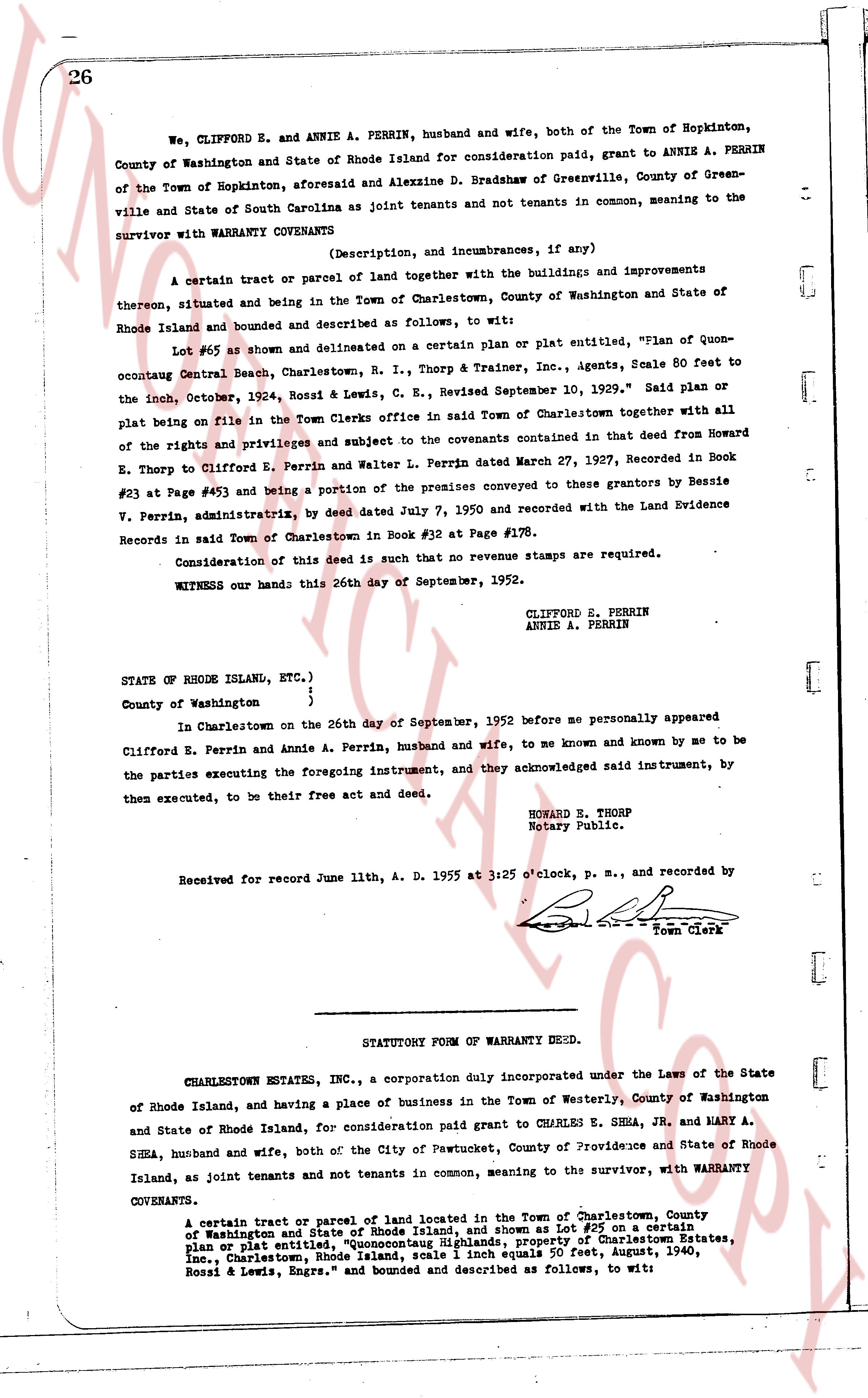
26
We, CLIFFORD E. and ANNIE A. PERRIN, husband and wife, both of the Town of Hopkinton, County of Washington and State of Rhode Island for consideration paid, grant to ANNIE A. PERRIN of the Town of Hopkinton, aforesaid and Alexzine D. Bradshaw of Greenville, County of Greenville and State of South Carolina as joint tenants and not tenants in common, meaning to the survivor with WARRANTY COVENANTS
(Description, and incumbrances, if any)
A certain tract or parcel of land together with the buildings and improvements thereon, situated and being in the Town of Charlestown, County of Washington and State of Rhode Island and bounded and described as follows, to wit:
Lot #65 as shown and delineated on a certain plan or plat entitled, "Plan of Quonocutaug Central Beach, Charlestown, R. I., Thorp & Trainer, Inc., Agents, Scale 60 feet to the inch, Cotter, Rossi & Lewis, C. E., Revised September 10, 1929." Said plan or plat being on file in the Town Clerks office in said Town of Charlestown together with all of the rights and privileges and subject to the covenants contained in that deed from Howard E. Thorp to Clifford E. Perrin and Walter L. Perrin dated March 27, 1927, Recorded in Book #23 at Page #65 and being a portion of the premises conveyed to these grantors by Bessie V. Perrin, administratrix, by deed dated July 7, 1950 and recorded with the Land Evidence Records in said Town of Charlestown in Book #32 at Page #178.
Consideration of this deed is such that no revenue stamps are required.
WITNESS our hands this 26th day of September, 1952.
CLIFFORD E. PERRIN
ANNIE A. PERRIN
STATE OF RHODE ISLAND, ETC.)
)
County of Washington ;
In Charlestown on the 26th day of September, 1952 before me personally appeared Clifford E. Perrin and Annie A. Perrin, husband and wife, to me known and known by me to be the parties executing the foregoing instrument, and they acknowledged said instrument, by them executed, to be their free act and deed.
HOWARD E. THORP
Notary Public.
Received for record June 11th, A. D. 1955 at 3:25 o'clock, p. m., and recorded by [signature] Town Clerk
----
STATUTORY FORM OF WARRANTY DEED.
CHARLESTOWN ESTATES, INC., a corporation duly incorporated under the Laws of the State of Rhode Island, and having a place of business in the Town of Westerly, County of Washington and State of Rhode Island, for consideration paid grant to CHARLES E. SHEA, JR. and MARY A. SHEA, husband and wife, both of the City of Pawtucket, County of Providence and State of Rhode Island, as joint tenants and not tenants in common, meaning to the survivor, with WARRANTY COVENANTS.
a certain tract or parcel of land located in the Town of Charlestown, County of Washington and State of Rhode Island, and more shown as Lot #65 on a certain plan or plat entitled "Highlands Property of Charlestown Estates, Inc., Charlestown, Rhode Island, scale 1 inch equals 50 feet, August, 1940, Rossi & Lewis, Engrs." and bounded and described as follows, to wit:
page 2 · read by Gemma vision
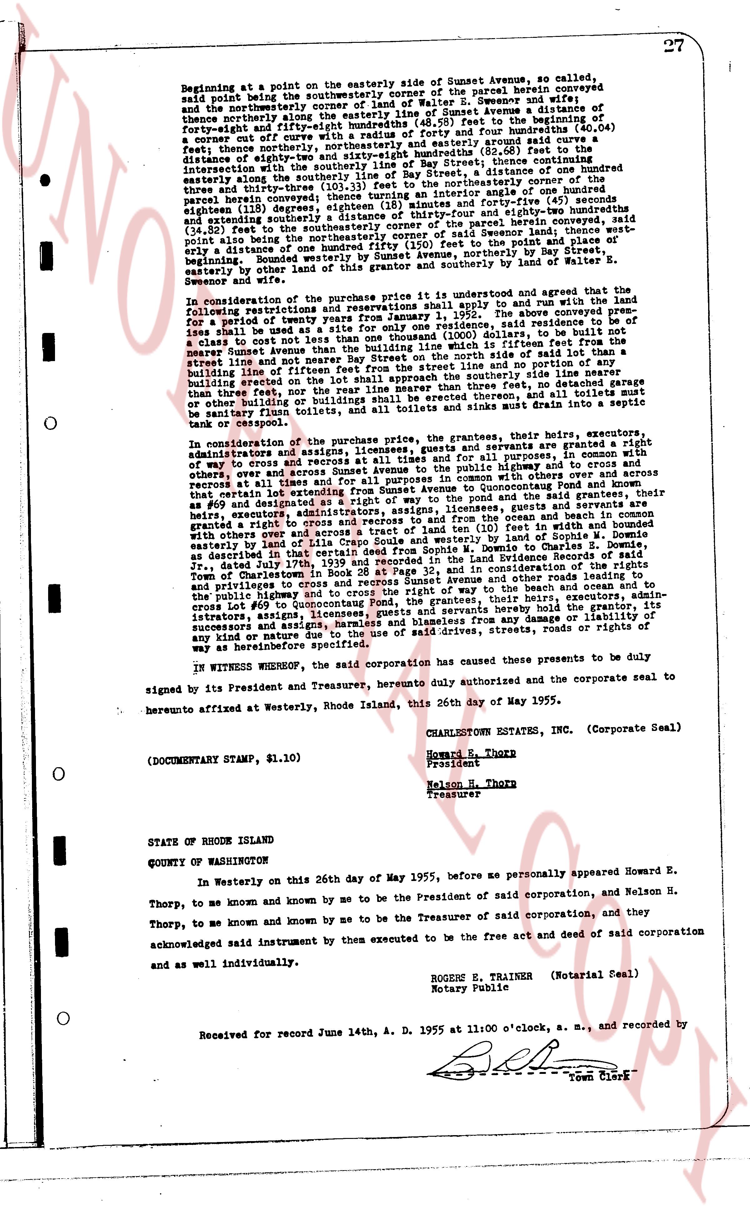
27
Beginning at a point on the easterly side of Sunset Avenue, so called,
said point being a point on the southwesterly corner of the parcel herein conveyed
and the northwesterly corner of the parcel of Walter S. Sewenow and his
northwesterly along the southwesterly line of Sunset Avenue a distance of
forty-eight and fifty-eight hundredths (48.58) feet to the beginning of
a curve cutting off the northeasterly corner of said parcel (40.04)
feet; thence northerly, northeasterly, northeasterly and easterly around said curve a
distance of eighty-two and thirty-eight hundredths (82.38) feet to the
intersection with the southeasterly line of Bay Street; thence continuing
easterly along the southerly line of Bay Street, a distance of hundred
three and thirty-three hundredths (103.33) feet to the northeasterly corner of the
parcel herein conveyed; thence turning south forty-five degrees forty-five minutes and forty-five(45) seconds
eighteen (18) degrees southeastly, a distance of one hundred forty-four and
extending southerly a distance of thirty-four and fifty-four hundredths (34.54) feet
to the southeasterly corner of the parcel herein conveyed, said
point being also the southwesterly corner of said Sewenow land and point of place of
entry. distance of one hundred twenty feet to the point of place of
beginning. Bounded westerly by Sunset Avenue, northerly by Bay Street,
easterly by bounded easterly by the land of Sunset Avenue by the land of Mr.
Sewenow and wife.
In consideration of the purchase price it is understood and agreed that the
following restrictions and reservations shall apply to and run with the land:
first, that no residential uses shall be permitted for a period of
years until January 1, 1955. The above conveyed pres-
ises shall be used for a site for a residential dwelling, said residential dwelling to be
a class A cottage not to exceed one thousand (1000) dollars, to be built not to
the street line and not to be located on the north side of said lot than a
nearer Sunset Avenue than the building line specified in the following:
street line and not to be located on the north side of said lot than a
building line of fifteen feet from the street line and not to be located on the
southerly side than three feet, nor the rear line nearer than three feet, either
on garage building or any other structure, and all toilets must be
sanitary flush toilets, and all toilets and sinks must drain into a septic
tank or cesspool.
In consideration of the purchase price, the grantors, their heirs, executors,
administrators and assigns, licensees, grantees and servients are granted right
of way to cross and recross Sunset Avenue to the public highway and to cross and
recross other ways and roads and all ways and paths common, with others
cross, over all roads and ways extending from Sunset Avenue to Quoconnock Point and known as
that contain relevant an easement extending from Sunset Avenue to Quoconnock Point and known as
#69 and designated as a "road" on the road and bridge map of Rhode Island,
their heirs, executors, administrators, licensees, grantees and servients are granted
a right to cross and recross the public highway and to cross and recross
easterly by the land of Lila Crapo Soulé and west and southwesterly by the land
as described in the deed from Henrietta M. Downe to Charles E. Downe, as
described in the deed from Henrietta M. Downe to Charles E. Downe,
dated July 17th, 1939 and recorded in the Land Evidence Book 21, page 111,
dated July 17th, 1939 and recorded in the Land Evidence Book 21, page 111,
and privileges to cross and recross Sunset Avenue and other ways and roads
to the public highway and to cross and recross the beach and ocean and to
cross Lot #69 to Quoconnock Point the grantors, their heirs, executors, ad-
ministrators, assigns, licensees, grantees and servients are hereby hold harmless from any damage or liability of
any kind or nature due to the use of said drives, streets, roads or rights of
way as hereinafter specified.
IN WITNESS WHEREOF, the said corporation has caused these presents to be duly
signed by its President and Treasurer, hereunto duly authorized and the corporate seal to
heretounto affixed at Westerly, Rhode Island, this 26th day of May 1955.
CHARLESTOWN ESTATES INC. (Corporate Seal)
Howard E. Thorp
President
Nelson H. Thorp
Treasurer
(DOCUMENTARY STAMP, $1.10)
STATE OF RHODE ISLAND
COUNTY OF WASHINGTON
In Westerly on this 26th day of May 1955, before me personally appeared Howard E.
Thorp, to me known and known by me to be the President of said corporation, and Nelson H.
Thorp, to me known and known by me to be the Treasurer of said corporation, and they
acknowledged said instrument by them executed to be the free act and deed of said corporation
and as well individually.
BOGERS E. TRAINER (Notarial Seal)
Notary Public
Received for record June 14th, A. D. 1955 at 11:00 o'clock, a. m., and recorded by
[Signature]
Town Clerk
The page as recorded