The instrument's own words
page 1 · read by Gemma vision
19
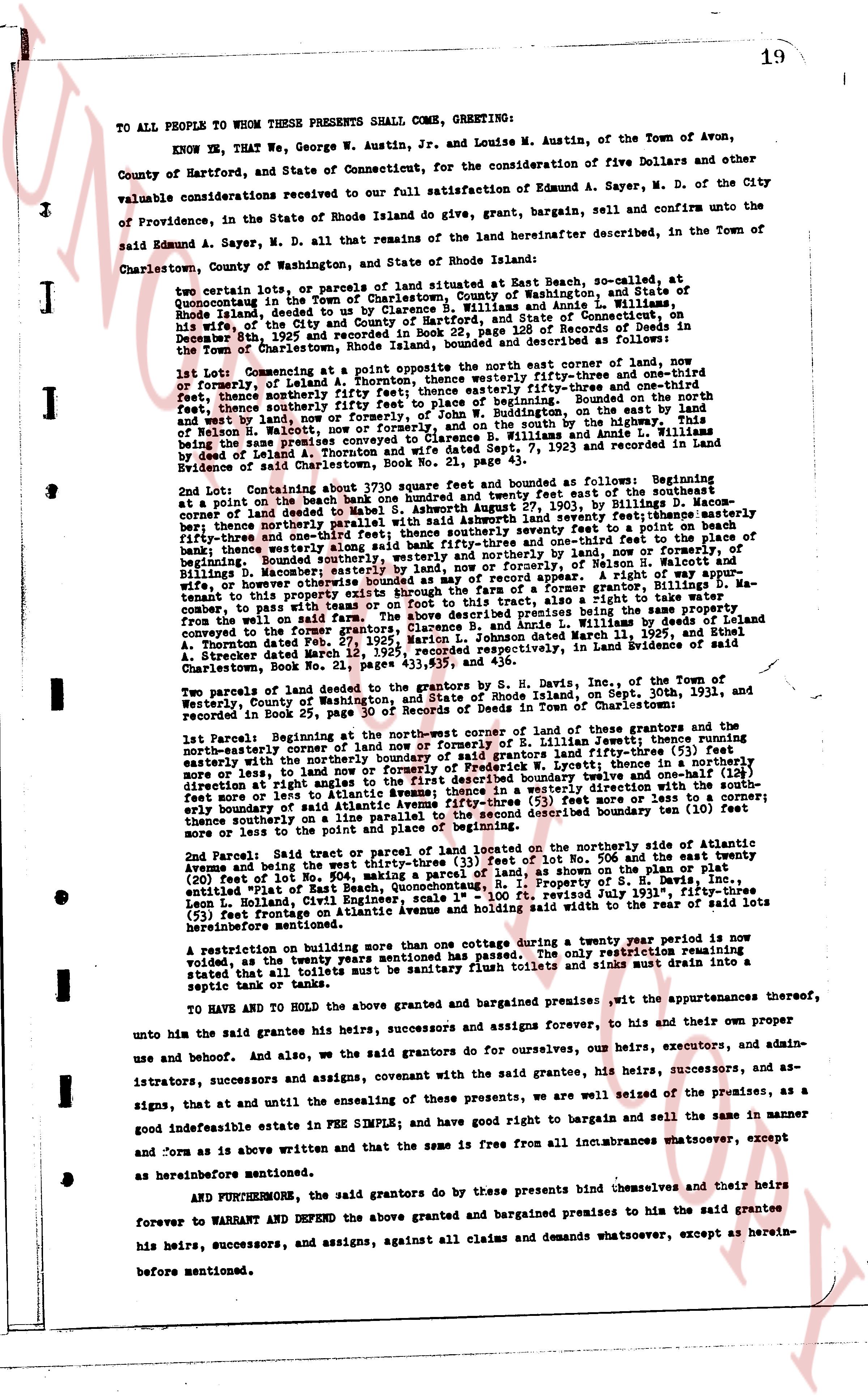
TO ALL PEOPLE TO WHOM THESE PRESENTS SHALL COME, GREETING:
KNOW YE, That WE, George W. Austin, Jr. and Louise M. Austin, of the Town of Avon, County of Hartford, and State of Connecticut, for the consideration of five Dollars and other valuable considerations received our full satisfaction of Edmund A. Sayer, M. D. of the City of Providence, in the State of Rhode Island give, grant, bargain, sell, and confirm unto the said Edmund A. Sayer, M. D. all that remains of the land hereinafter described, in the Town of Charlestown, County of Washington, and State of Rhode Island hereinafter:
Two certain lots, or parcels of land situated at East Beach, so-called, at Quonochontaug in the Town of Charlestown, County of Washington, and State of Rhode Island, formerly granted by deed of A. Thornton Austin, to S. B. Williams and Annie L. Williams; wife of the City and County of Hartford, and State of Connecticut, on December 8th, 1925 and recorded in Book 25 of Land Evidence, page 156 of Records of Deeds in the town of Charlestown, Rhode Island, bounded and described as follows:
1st Lot: Commencing at a point opposite the northeast corner of said corner, now and formerly, of Leandol A. Thornton; thence southeasterly fifty-three inches and one-third feet, thence southerly fifty-three feet one inch; thence easterly fifty-three inches and one-third feet, thence southerly fifty feet piece to a stone wall of W. W. Buddington, on the east by the land of Nelson H. Walcott, now or formerly, and on the south by the highway from the house of the late Mrs. Williams and Annie L. Williams was Annie L. Williams by deed of Leandol A. Thornton and wife dated Sept 7, 1923 and recorded in Land Evidence of said Charlestown, Book 23, page 111.
2nd Lot: Containing about 3710 square feet and bounded as follows: Beginning at a point on the beach one hundred and twenty feet and twenty three feet of the southerly corner of said land of Leandol A. Thornton, now or formerly, by deed to S. B. Williams; thence northerly parallel with the seabed as shown survey letter seventy seventeen feet masonry fifty-three inches and one-third feet, and thence northerly along said bank fifty-three inches and one-third feet to the place of beginning. Bounded southerly, eastwards, and westwards, by the land now or formerly of Nelson B. Walcott and Billings, N. Masonry; northerly by the beach and by the land, now or formerly, of S. B. Williams, now tenant to this property as shown on the plan of the former a grantor, Billings, D. Masonry, tenant to this property as shown on the plan of the former a grantor, Billings, D. Masonry, consequent to this property as shown on the plan of the former a grantor, Clarence Branch and Annie L. Williams by deed dated March 11, 1927, and Stabel A. Strecker dated March 12, 1929, recorded respectively, in Land Evidence of said Charlestown, Book 28, page 111.
Two parcels of land deeded to the grantors by S. H. Davis, Inc., of the Town of Westerly, County of Washington, and State of Rhode Island, on Sept. 30th, 1921, and recorded in Book 25, page 111 of Land Evidence for the Town of Charlestown, Rhode Island:
the 1st parcel: Beginning at the Northeastern corner of the land of George S. Davis, Inc. thence northeasterly corner of the land now or formerly of R. Lillian Leet; thence running northeasterly corner by the northerly boundary of Leandol A. Thornton; thence running northeasterly on the northerly boundary of the land of Frederick W. Lyttets; thence in a northerly direction at right angles to the first described line, seventy twelve and one-half feet more or less, to the land of S. H. Davis, Inc.; thence in a westerly direction with the southerly boundary of said Atlantic Avenue fifty-three (53) feet more or less, to the land of S. H. Davis, Inc.; thence running southerly along the boundary ten (10) feet thence southerly on a line to the place of beginning.
2nd Parcel: Said tract or parcel of land located on the northerly side of Atlantic Avenue and being the west part of Lot No. 506, and the east twenty feet of Lot No. 506 and the east twenty (20) feet of Lot No. 504, as shown on the plan or plat, entitled Map of East Beach, as property of S. H. Davis, Inc., prepared by J. S. Moore, Engin, Leon L. Holland, Civil Engineer, scale 1" = 100 ft, revised July 1931, fifty-three feet (53) feet frontage on Atlantic Avenue and holds said width to the rear, the total area being hereinafter mentioned.
A restriction on building more than one cottage during a twenty year period is now voided, as the twenty years mentioned has passed. The only restriction remaining stated that all toilets must be sanitary flush toilets and sinks must drain into a septic tank or tanks.
TO HAVE AND TO HOLD the above granted and bargained premises with all the appurtenances thereof, unto him the said grantee his heirs, successors, and assigns forever, to his and to their own proper use and behoof. And also, we the said grantors do for ourselves, our heirs, executors, and administrators, successors and assigns, covenant with the said grantee, his heirs, successors, and assigns, that at and until the ensealing of these presents, we are well seized of the premises, as a good indefeasible estate IN FEE SIMPLE, and have good right to bargain and sell the same in the manner and form as is above written and that the same is free from all incumbrances whatsoever, except as hereinbefore mentioned.
AND FURTHERMORE, the said grantors do by these presents bind themselves and their heirs forever to WARRANT AND DEFEND the above granted and bargained premises to him the said grantee his heirs, successors, and assigns, against all claims and demands whatsoever, except as hereinbefore mentioned.
The page as recorded