The instrument's own words
page 1 · read by Gemma vision
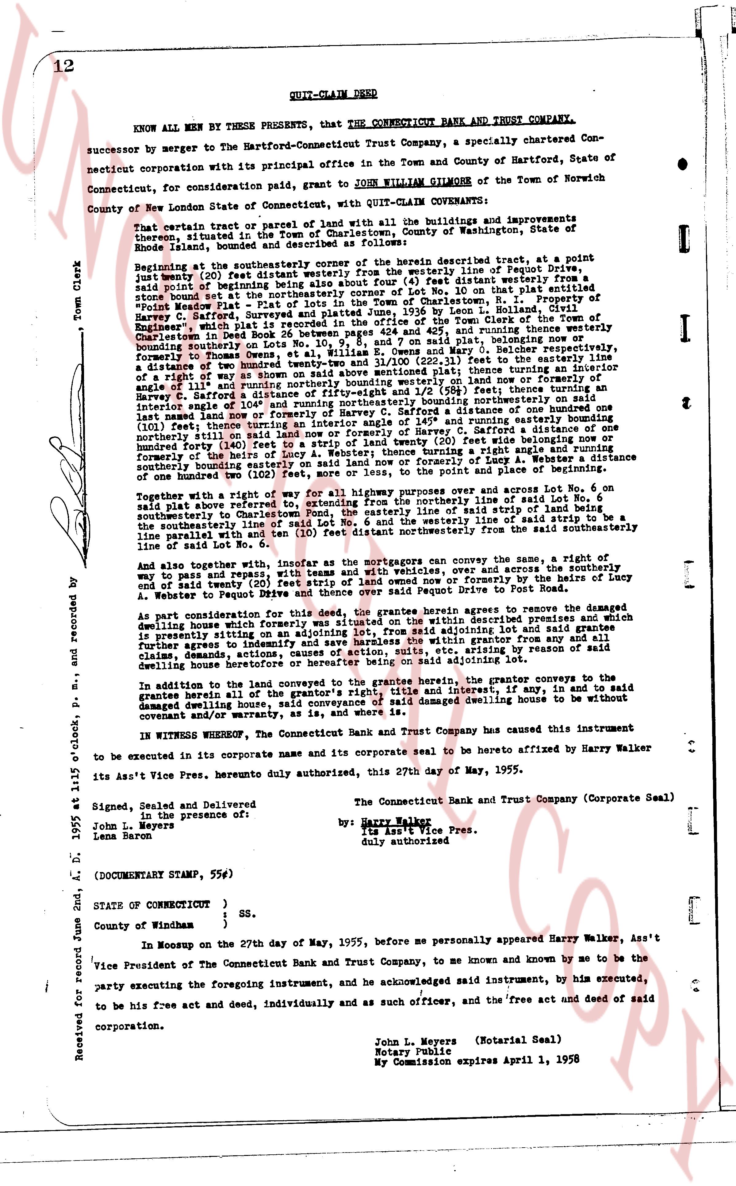
12 QUIT-CLAIM DEED
KNOW ALL MEN BY THESE PRESENTS, that THE CONNECTICUT BANK AND TRUST COMPANY,
successor by merger to the Hartford-Connecticut Trust Company, a specially chartered Connecticut corporation with its principal office in the Town and County of Hartford, State of Connecticut, for consideration said paid, grant to JOHN WILLIAM GILMORE of the Town of Norwich County of New London State of Connecticut, with QUIT-CLAIM COVENANTS:
That certain parcel of land with all the buildings and improvements thereon, situated in the Town of Charlestown, County of Washington, State of Rhode Island, bounded and described as follows:
Beginning at the southeasterly corner of the herein described tract, at a point just twenty (20) feet distant westerly from the westerly line of Rogue Point Ave, said point of beginning being also just four feet distant westerly from the southeasterly corner of the northeasterly corner of Lot no. 10 on that plat entitled "Point Meadow Plat - Plat of lots of land in the Town of Charlestown, County of Washington, State of Rhode Island, filed June 26, 1936 by Leon L. Holland, Civil Engineer, which plat is recorded in the land evidence records of the Town of Charlestown, Rhode Island, in book 24, page 12, consisting of lots 424 and 425, and ending running thence westerly furthermore to those boundaries of Lot No. 9, and 7, and Mary O. Belcher respectively, furthermore to those boundaries of Lot No. 8, and Mary O. Belcher respectively, furthermore a distance of two hundred twenty five and 11/100 (225.11) feet to the line of a right of way forty (40) feet wide, then turning an angle of 110° and running northeasterly bounding on land of Mrs. C. Defoe a distance of one hundred twenty five and 33/100 (125.33) feet, thence turning an angle of 111° and running northeasterly bounding on land of Mrs. C. Defoe a distance of one hundred twenty five and 33/100 (125.33) feet, thence turning an interior angle of 104° and running northeasterly bounding on northeasterly side on a distance of one hundred twenty five and 33/100 (125.33) feet, thence turning an interior angle of 104° and running easterly bounding northeasterly side on a distance of one hundred twenty five and 33/100 (125.33) feet, thence turning an interior angle of 145° and running easterly bounding northeasterly side on a distance of one hundred twenty five and 33/100 (125.33) feet, thence running northeasterly forty (40) feet to a strip of land twenty (20) feet wide belonging now or formerly to the heirs of Mary A. L. Webster, then turning a right angle and running southeasterly bounding on land now or formerly of the heirs of Lucy A. Webster a distance of one hundred two (102) feet, more or less, to the point and place of the beginning of said lot.
Together with a right of way for all highways purposes over and across Lot No. 6 on said plat also described herein, specifically the westerly line of the northerly side of Lot No. 6 said plat also described herein, running from the southeasterly corner of said line of southeasterly centerline to Charlestown Pond, the easterly line of said strip of land being a line parallel with and ten (10) feet distant northeasterly from the said southeasterly line of said Lot No. 6.
And also together with, insofar as the mortgagors can convey the same, a right of way to pass and repass, with teams and vehicles, over and across the southerly and or said strip of land described above, from Rogue Point Ave, formerly by the heirs of Lucy A. Webster to Rogue Point Drive and thence over said Rogue Point Drive to Fast Road.
As part consideration for this deed, the grantee herein agrees to remove the damaged dwelling house which formerly stood on said tract of land, and all claims thereunto, and claims to any building on an adjoining lot, from said adjoining lot and grantee further agrees to indemnify and save harmless the grantor from all suits, costs, actions, suits, etc, arising by reason of said removing said dwelling house or heretofore or herein being on said adjoining lot.
In addition to the land conveyed to the grantee herein, the grantor conveys to the grantee, without warranty, the right to enter on, remove and dispose of, any, in and to said damaged dwelling house, said conveyance of said damaged dwelling house to be without covenant and/or warranty, as is said land.
IN WITNESS WHEREOF, the Connecticut Bank and Trust Company has caused this instrument to be executed in its corporate name and its corporate seal to be hereto affixed by Harry Walker its Asst Vice Pres. herewith duly authorized, this 27th day of May, 1955.
Signed, Sealed and Delivered
in the presence of:
John L. Meyers
Lena Baron
The Connecticut Bank and Trust Company (Corporate Seal)
by: Harry Walker
Its Asst Vice Pres.
duly authorized
(DOCUMENTARY STAMP, 55¢)
STATE OF CONNECTICUT )
) ss.
County of Windham )
In Moosup on the 27th day of May, 1955, before me personally appeared Harry Walker, Asst Vice President of the Connecticut Bank and Trust Company, to me so known and known by me to be the party executing the foregoing instrument, and he acknowledged said instrument, by him executed, to be his free act and deed, individually and as such officer, and the free act and deed of said corporation.
(Notarial Seal)
John L. Meyers
Notary Public
My Commission expires April 1, 1958
Received for record June 2nd, A. D. 1955 at 11:15 o'clock, P. M., and recorded by
The page as recorded