The instrument's own words
page 1 · read by Gemma vision
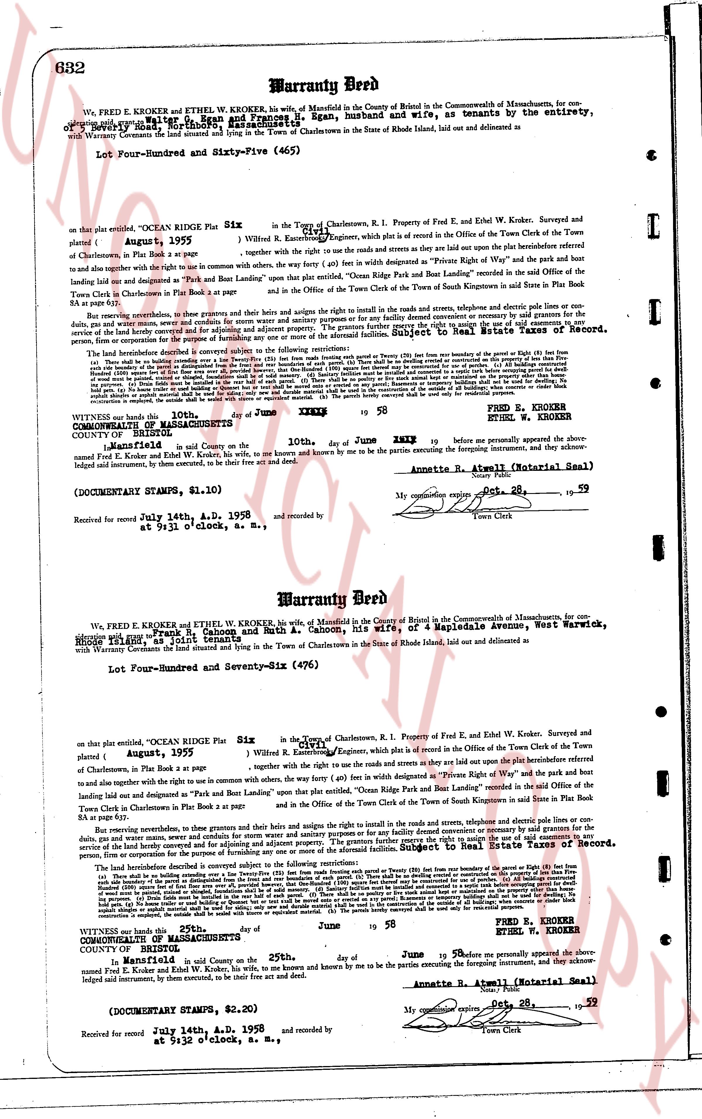
632 Warranty Deed
We, FRED E. KROKER and ETHEL W. KROKER, his wife, of Mansfield in the County of New London in the Commonwealth of Massachusetts, for consideration paid to us by Walter G. Ryan and Frances B. Ryan, husband and wife, as tenants by the entirety, of Warwick, Rhode Island, grant, bargain, sell and convey and Warranty Covenant the land situated and lying in the Town of Charlestown in the State of Rhode Island, laid out and delineated as
Lot Four-Hundred and Sixty-Five (465)
on that plat entitled, "OCEAN RIDGE Plat Six" in the Town of Charlestown, R.I. Property of Fred E. and Ethel W. Kroker, Surveyed and signed W. Russell Fanning, Engineer, which plat is on record in the Office of the Town Clerk of the Town of Charlestown, Plat Book 4 page 2. Together with all the uses and rights to use the roads and streets as they are laid out upon the plat heretofore referred to and to have and hold the same together with the right to use in common with others, the way (other 40 ft) in width designated as "Private Right of Way" and the park bout limiting land laid out and designated as "Park and Boat Landing" upon that plat entitled, "Ocean Ridge Park and Boat Landing" recorded in the said Office of the Town Clerk Charlestown in Plat Book 2 at page 2 and in the Office and in the Town Clerk of the Town of South Kingstown in said State in Plat Book 8A at page 63.
Reserving nevertheless, in these premises, that the grantors and their heirs and assigns the right to install in the roads and streets, telephone and electric pole lines or conduits, gas, water and sewer mains, etc. provided that such installation shall not interfere with the convenient use or enjoyment of the premises by the grantees or their heirs and assigns. Reserving also the right to cut timber for enclosing and for adjoining property. The grantors further reserve the right to utilize the right of way mentioned herein for the purpose of accessing other parcels of land owned by them or their heirs and assigns. This reservation is subject to Book 34 Page 632 of the Land Evidence Records of Charlestown, for persons, firm or corporation for the purposes of residence.
The described parcel is conveyed subject to the following restrictions to the selanjutnya reservations:
(a) There shall be no building constructed upon any lot (excepting the house and garage) within forty (40) feet from the boundary of the Parcel (or 60 feet from the boundary of the Parcel if 60 feet from the boundary of the Parcel). (b) No building shall be constructed upon any lot (excepting the house and garage) within twenty (20) feet from the boundary of any neighboring parcel of that subdivision. (c) All buildings constructed upon any lot shall be set back from the road line at least thirty (30) feet. (d) No building shall be constructed upon any lot except for residential purposes. (e) All buildings constructed upon any lot shall be used for residential purposes only. (f) No building shall be constructed upon any lot except for residential purposes. (g) No business, commercial, industrial or professional office shall be conducted upon any lot. (h) No livestock, poultry or other animals shall be kept on any lot. (i) No trailers, campers, caravans, scrap metal or automobiles shall be stored on any lot. (j) No structures or temporary buildings shall be set up and used for dwelling. (k) No ditch, pond or stream shall be obstructed or diverted without the consent of the owner of the affected property. (l) No trees shall be cut unless necessary for the construction of a building. (m) Only shrubs limited to be planted in the east half of each parcel. (n) There shall be no planting or anything else that will obstruct the view of the road. (o) No fences shall be erected along the road line. (p) No signs shall be placed on any lot. (q) No garbage, refuse or other waste material shall be deposited on any lot. (r) No noise, odor or other nuisance shall be created on any lot. (s) Any structure or improvement constructed, is subject the estate shall be vested with owner as principal. (t) The parcels hereby conveyed shall be used only for residential purposes.
FRED E. KROKER
ETHEL W. KROKER
WITNESSED whose hand this 25th day of June 19 58 before me personally appeared the above named Fred E. Kroker and Ethel W. Kroker, his wife, to me known and known by me to be the parties executing the foregoing instrument, and acknowledged signed instrument, by them executed, to be their free act and deed.
COUNTY OF NEW LONDON
STATE OF CONNECTICUT
In Mansfield, in said County on the 25th day of June 19 58 before me personally appeared the above named Fred E. Kroker and Ethel W. Kroker, his wife, to me known and known by me to be the parties executing the foregoing instrument, and acknowledged signed instrument, by them executed, to be their free act and deed.
Annette R. Atwell (Notarial Seal)
(DOCUMENTARY STAMPS, $1.10)
Received for record July 14th, A.D. 1958 and recorded by
at 9:31 o'clock, S. M., by [?]
My commission expires Oct 28, 59
Town Clerk
----
Warranty Deed
We, FRED E. KROKER and ETHEL W. KROKER, his wife, of Mansfield in the County of New London in the Commonwealth of Massachusetts, for consideration paid to us by Frank C. Cahoon and Ruth A. Cahoon, his wife, of 4 Mapledale Avenue, West Warwick, Rhode Island, grant, bargain, sell and convey and Warranty Covenant the land situated and lying in the Town of Charlestown in the State of Rhode Island, laid out and delineated as
Lot Four-Hundred and Seventy-Six (476)
on that plat entitled, "OCEAN RIDGE Plat Six" in the Town of Charlestown, R.I. Property of Fred E. and Ethel W. Kroker, Surveyed and signed W. Russell Fanning, Engineer, which plat is on record in the Office of the Town Clerk of the Town of Charlestown, Plat Book 4 page 2. Together with all the uses and rights to use the roads and streets as they are laid out upon the plat heretofore referred to and to have and hold the same together with the right to use in common with others, the way (other 40 ft) in width designated as "Private Right of Way" and the park bout limiting land laid out and designated as "Park and Boat Landing" upon that plat entitled, "Ocean Ridge Park and Boat Landing" recorded in the said Office of the Town Clerk Charlestown in Plat Book 2 at page 2 and in the Office and in the Town Clerk of the Town of South Kingstown in said State in Plat Book 8A at page 63.
Reserving nevertheless, in these premises, that the grantors and their heirs and assigns the right to install in the roads and streets, telephone and electric pole lines or conduits, gas, water and sewer mains, etc. provided that such installation shall not interfere with the convenient use or enjoyment of the premises by the grantees or their heirs and assigns. Reserving also the right to cut timber for enclosing and for adjoining property. The grantors further reserve the right to utilize the right of way mentioned herein for the purpose of accessing other parcels of land owned by them or their heirs and assigns. This reservation is subject to Book 34 Page 632 of the Land Evidence Records of Charlestown, for persons, firm or corporation for the purposes of residence.
The described parcel is conveyed subject to the following restrictions to the selanjutnya reservations:
(a) There shall be no building constructed upon any lot (excepting the house and garage) within forty (40) feet from the boundary of the Parcel (or 60 feet from the boundary of the Parcel if 60 feet from the boundary of the Parcel). (b) No building shall be constructed upon any lot (excepting the house and garage) within twenty (20) feet from the boundary of any neighboring parcel of that subdivision. (c) All buildings constructed upon any lot shall be set back from the road line at least thirty (30) feet. (d) No building shall be constructed upon any lot except for residential purposes. (e) All buildings constructed upon any lot shall be used for residential purposes only. (f) No building shall be constructed upon any lot except for residential purposes. (g) No business, commercial, industrial or professional office shall be conducted upon any lot. (h) No livestock, poultry or other animals shall be kept on any lot. (i) No trailers, campers, caravans, scrap metal or automobiles shall be stored on any lot. (j) No structures or temporary buildings shall be set up and used for dwelling. (k) No ditch, pond or stream shall be obstructed or diverted without the consent of the owner of the affected property. (l) No trees shall be cut unless necessary for the construction of a building. (m) Only shrubs limited to be planted in the east half of each parcel. (n) There shall be no planting or anything else that will obstruct the view of the road. (o) No fences shall be erected along the road line. (p) No signs shall be placed on any lot. (q) No garbage, refuse or other waste material shall be deposited on any lot. (r) No noise, odor or other nuisance shall be created on any lot. (s) Any structure or improvement constructed, is subject the estate shall be vested with owner as principal. (t) The parcels hereby conveyed shall be used only for residential purposes.
FRED E. KROKER
ETHEL W. KROKER
WITNESSED whose hand this 25th day of June 19 58 before me personally appeared the above named Fred E. Kroker and Ethel W. Kroker, his wife, to me known and known by me to be the parties executing the foregoing instrument, and acknowledged signed instrument, by them executed, to be their free act and deed.
COUNTY OF NEW LONDON
STATE OF CONNECTICUT
In Mansfield, in said County on the 25th day of June 19 58 before me personally appeared the above named Fred E. Kroker and Ethel W. Kroker, his wife, to me known and known by me to be the parties executing the foregoing instrument, and acknowledged signed instrument, by them executed, to be their free act and deed.
Annette R. Atwell (Notarial Seal)
(DOCUMENTARY STAMPS, $2.20)
Received for record July 14th, A.D. 1958 and recorded by
at 9:32 o'clock, S. M., by [?]
My commission expires Oct 28, 59
Town Clerk
The page as recorded