The instrument's own words
page 1 · read by Gemma vision
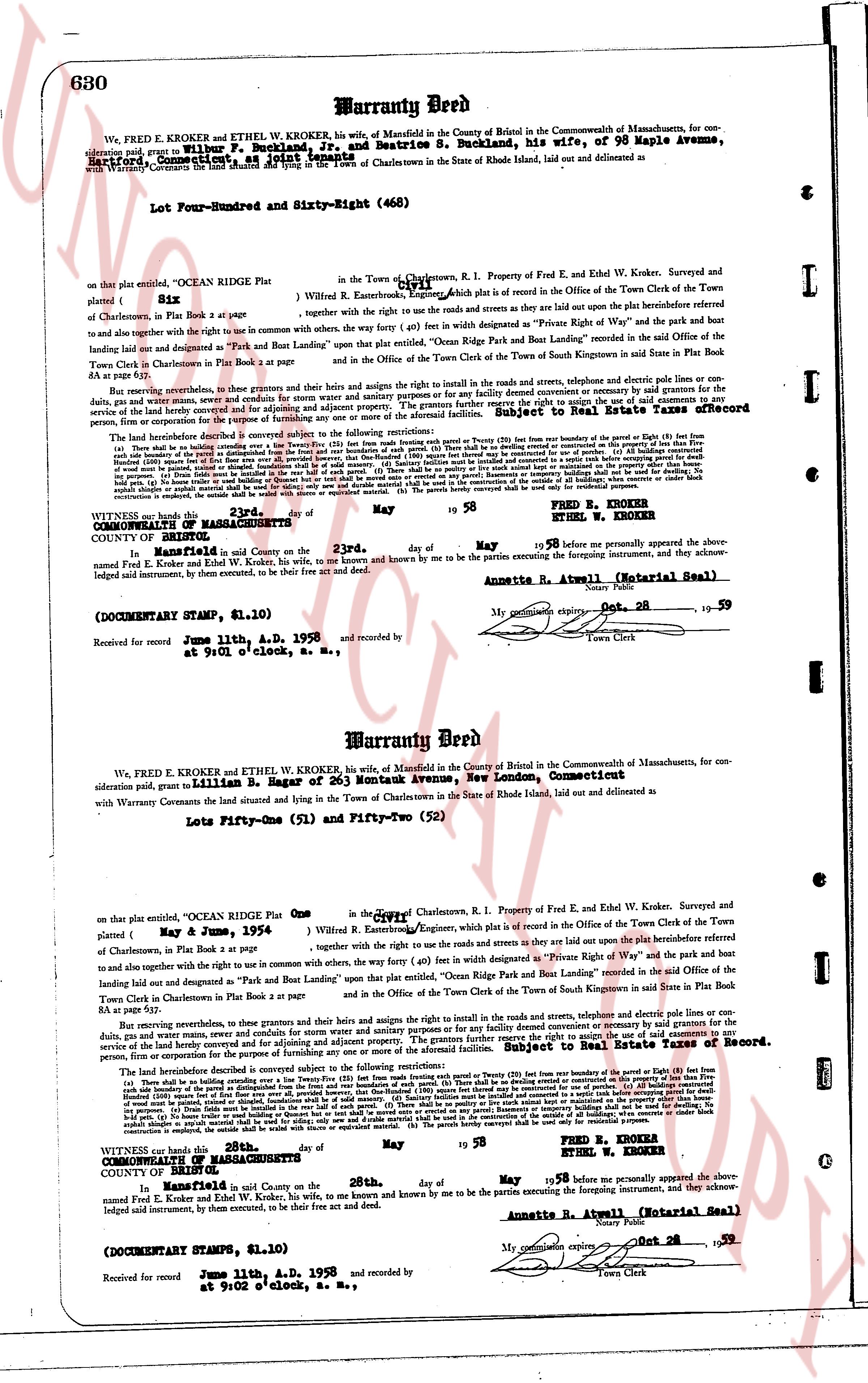
630 Warranty Deed
We, FRED E. KROKER and ETHEL W. KROKER, his wife, of Mansfield in the County of Bristol in the Commonwealth of Massachusetts, for
consideration said, paid to Wilbur P. Buckland, Jr., and Beatrice S. Buckland, his wife, of 98 Maple Avenue,
Hartford, Connecticut, as follows:
With Warranty Covenants the land situated and lying in the Town of Charlestown in the State of Rhode Island, laid out and delivered as
Lot Four-Hundred and Sixty-Eight (468)
on that plat entitled, "OCEAN RIDGE Plat" in the Town of Charlestown, R.I. Property of Fred E. and Ethel W. Kroker, Surveyed and
platted by [?] W. Rmouseenter, Engineer, Ocean Ridge plat is of record in the Office of the Town Clerk of the Town
of Charlestown, in the Book Plat 2 at page 10
together with the right to use the roads and streets and towen [?] roads and streets are lay out upon the platinsertBeforeed there
and to use in common with the right to use in common with others, the way forty (40) feet in width now designated as "Private Right of Way" and the park that
landing laid out and designated as "Park and Boat Landing" upon that plat entitled, "Ocean Ridge Park and Boat Landing" recorded in the said Office of the
Town Clerk in Charlestown in Book Plat 2 at page 10
and in the Office of the Town Clerk of the Town of South Kingstown in said State in Plat Book 84 at page 52.
But reserving nevertheless, to these grantors and their heirs and assigns the rights and rights to install in the roads and streets, telephone and electric pole lines or com-
munication lines, gas, data wires and sewer pipes and water lines and appurtenances adjacent. The grantors further reserve the right to use, set out the amount of payments to
be made by the grantee for the maintenance of said roads and streets, and to maintain the same. This reservation is subject to the approval of the [?] Record
person, firm or corporation for the purpose of furthering any [?]
The land herein described is subject to the following restrictions and reservations: (1) All buildings constructed
(a) there shall be no building extending over the line of the street or road (b) No building shall be erected within twenty (20) feet from the boundary of the parcel or Eight (8) feet
from the boundary of the parcel or Eight (8) feet from the rear boundary or fronts of each parcel. (3) There shall be no building extending over the line of the street or road
of wood or stone be permitted on any part of each parcel. (4) All buildings constructed for use of purpose (4) All buildings constructed for use of
purpose. (5) No building shall be erected within twenty (20) feet from the boundary of the parcel or Eight (8) feet from the rear boundary or fronts of each parcel. (6)
of wood or stone be permitted on any part of each parcel. (7) There shall be no penalty or limit as to any temporary buildings shall be used or for dwelling. No
of wood or stone be permitted on any part of each parcel. (8) No building shall be erected within twenty (20) feet from the boundary of the parcel or Eight (8) feet from
the rear boundary or fronts of each parcel. (9) No temporary or emergency buildings shall be used or for dwelling. No
of wood or stone be permitted on any part of each parcel. (10) No building shall be erected within twenty (20) feet from the boundary of the parcel or Eight (8) feet from
the rear boundary or fronts of each parcel. (11) The stone walls be rebuilt or with stones or equivalent material. (12) The parcels hereby conveyed shall be used only for residential purposes.
WITNESS our hands this 23rd day of May 19 58
FRED E. KROKER
ETHEL W. KROKER
COMMONWEALTH OF MASSACHUSETTS
COUNTY OF BRISTOL ss:
On this, the 23rd day of May 19 58 before me personally appeared the above-
named Fred E. Kroker and Ethel W. Kroker, his wife, to me known and by me to be the parties executing the foregoing instrument, and they acknow-
ledged said instrument, by them executed, to be their free act and deed.
Annette R. Atwell (Notarial Seal)
My commission expires Oct. 28 19 59
Town Clerk
(DOCUMENTARY STAMP $1.10)
Received for record June 11th, A.D. 1958 and recorded by
at 9:00 o'clock, in Book 34, page 630.
----
Warranty Deed
We, FRED E. KROKER and ETHEL W. KROKER, his wife, of Mansfield in the County of Bristol in the Commonwealth of Massachusetts, for con-
sideration said, paid to Lillian B. Hager of 265 Montauk Avenue, New London, Connecticut, as follows:
With Warranty Covenants the land situated and lying in the Town of Charlestown in the State of Rhode Island, laid out and delivered as
Lots Fifty-One (51) and Fifty-Two (52)
on that plat entitled, "OCEAN RIDGE Plat" in the Town of Charlestown, R.I. Property of Fred E. and Ethel W. Kroker, Surveyed and
platted by [?] W. Rmouseenter, Engineer, Ocean Ridge plat is of record in the Office of the Town Clerk of the Town
of Charlestown, in the Book Plat 2 at page 10
together with the right to use the roads and streets and towen [?] roads and streets are lay out upon the platinsertBeforeed there
and to use in common with the right to use in common with others, the way forty (40) feet in width now designated as "Private Right of Way" and the park that
landing laid out and designated as "Park and Boat Landing" upon that plat entitled, "Ocean Ridge Park and Boat Landing" recorded in the said Office of the
Town Clerk in Charlestown in Book Plat 2 at page 10
and in the Office of the Town Clerk of the Town of South Kingstown in said State in Plat Book 84 at page 52.
But reserving nevertheless, to these grantors and their heirs and assigns the rights and rights to install in the roads and streets, telephone and electric pole lines or com-
munication lines, gas, data wires and sewer pipes and water lines and appurtenances adjacent. The grantors further reserve the right to use, set out the amount of payments to
be made by the grantee for the maintenance of said roads and streets, and to maintain the same. This reservation is subject to the approval of the Real Estate Taxes of Record.
person, firm or corporation for the purpose of furthering any [?]
The land herein described is subject to the following restrictions and reservations: (1) All buildings constructed
(a) there shall be no building extending over the line of the street or road (b) No building shall be erected within twenty (20) feet from the boundary of the parcel or Eight (8) feet
from the boundary of the parcel or Eight (8) feet from the rear boundary or fronts of each parcel. (3) There shall be no building extending over the line of the street or road
of wood or stone be permitted on any part of each parcel. (4) All buildings constructed for use of purpose (4) All buildings constructed for use of
purpose. (5) No building shall be erected within twenty (20) feet from the boundary of the parcel or Eight (8) feet from the rear boundary or fronts of each parcel. (6)
of wood or stone be permitted on any part of each parcel. (7) There shall be no penalty or limit as to any temporary buildings shall be used or for dwelling. No
of wood or stone be permitted on any part of each parcel. (8) No building shall be erected within twenty (20) feet from the boundary of the parcel or Eight (8) feet from
the rear boundary or fronts of each parcel. (9) No temporary or emergency buildings shall be used or for dwelling. No
of wood or stone be permitted on any part of each parcel. (10) No building shall be erected within twenty (20) feet from the boundary of the parcel or Eight (8) feet from
the rear boundary or fronts of each parcel. (11) The stone walls be rebuilt or with stones or equivalent material. (12) The parcels hereby conveyed shall be used only for residential purposes.
WITNESS our hands this 28th day of May 19 58
FRED E. KROKER
ETHEL W. KROKER
COMMONWEALTH OF MASSACHUSETTS
COUNTY OF BRISTOL ss:
On this, the 28th day of May 19 58 before me personally appeared the above-
named Fred E. Kroker and Ethel W. Kroker, his wife, to me known and by me to be the parties executing the foregoing instrument, and they acknow-
ledged said instrument, by them executed, to be their free act and deed.
Annette R. Atwell (Notarial Seal)
My commission expires Oct. 28 19 59
Town Clerk
(DOCUMENTARY STAMPS $1.10)
Received for record June 11th, A.D. 1958 and recorded by
at 9:00 o'clock, in Book 34, page 630.
The page as recorded