The instrument's own words
page 1 · read by Gemma vision
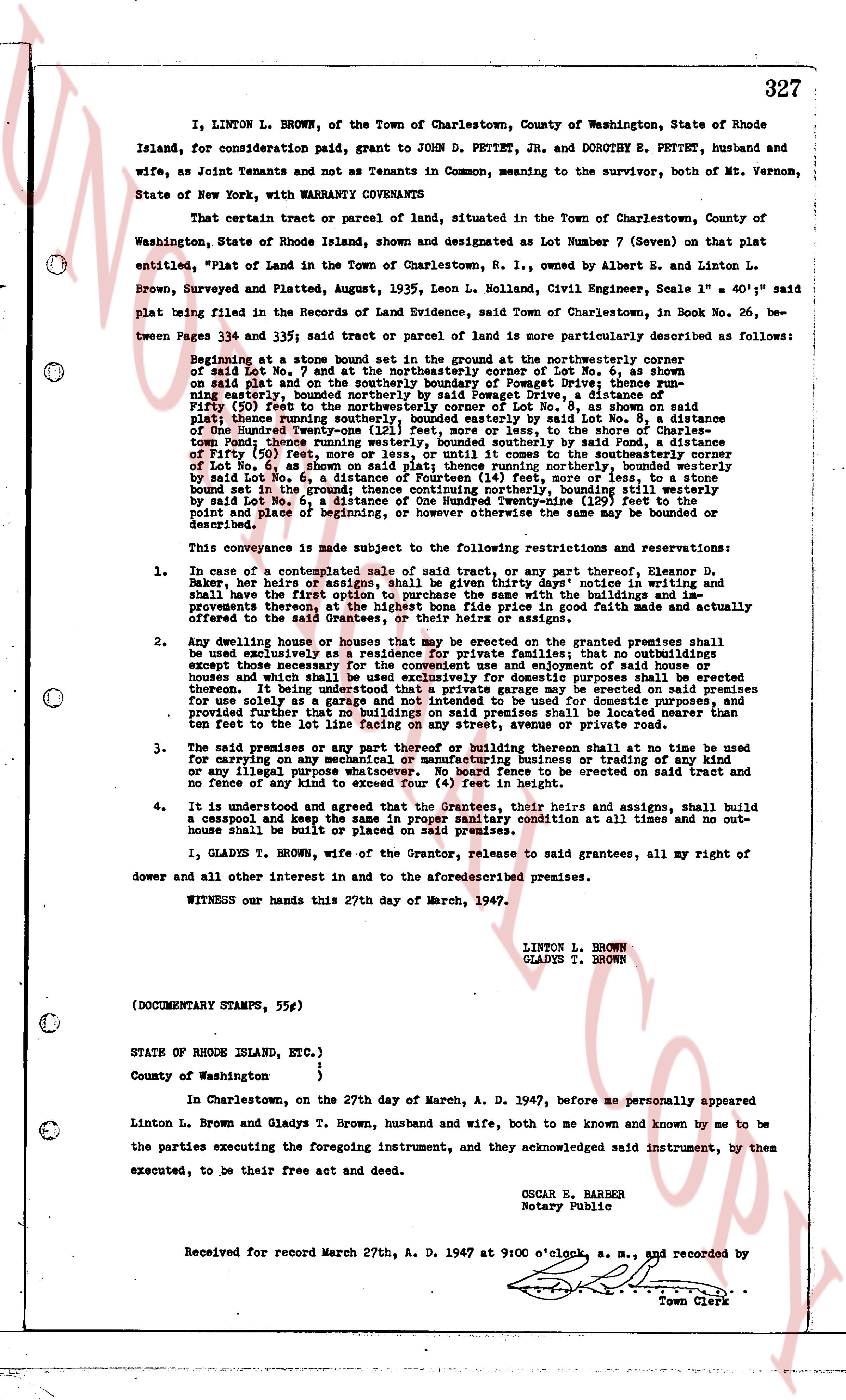
327
I, LINTON L. BROWN, of the Town of Charlestown, County of Washington, State of Rhode Island, for consideration paid grant to JOHN D. PETTET, JR. and DOROTHY E. PETTET, husband and wife, as Joint Tenants and not as Tenants in Common, meaning to the survivor, both of Mt. Vernon, State of New York, with WARRANTY COVENANTS
That certain tract or parcel of land, situated in the Town of Charlestown, County of Washington, State of Rhode Island, shown and designated as Lot Number 7 (Seven) on that plat entitled, "Plot of Land in the Town of Charlestown, R.I., owned by Albert E. and Linton L. Brown, Surveyed and Platted, August, 1935, Leon L. Nohland, Civil Engineer, Scale 1" = 40'" said plat being filed in the Records of Land Evidence, Town said Charlestown, in Book No. 26, between Pages 334 and 335; said tract or parcel of land is more particularly described as follows:
Beginning at a stone bound set in the ground at the northeasterly corner of said Lot No. 7 and by the northeasterly corner of Lot No. 6, as shown on said plat on the southerly boundary of Pomquet Drive; thence running southeasterly, bound by said Lot No. 6, along Pomquet Drive, a distance of One Hundred Fifty (50) feet to the northeasterly corner of Lot No. 8, as shown on said plat on the southerly boundary of Pomquet Drive; thence running southeasterly, bound by said Lot No. 8, a distance of One Hundred Twenty-one (121) feet, more or less, to the shore of the Stone Pond; thence running southwesterly, bound by the shore of said Stone Pond, a distance of One Hundred Fifty (50) feet, more or less, until it comes to the southeasterly corner of Lot No. 6, as shown on said plat; thence running northerly, bound by said Lot No. 6, a distance of One Hundred Twenty-one (121) feet, more or less, bound by said Lot No. 6, a distance of Fourteen (14) feet, more or less, to a stone bound set in the ground at the northeasterly corner of Lot No. 6, bounding on the easterly by said Lot No. 6, a distance of One Hundred Twenty-one (121) feet to the point of beginning, or however otherwise the same may be bounded or described.
This conveyance is made subject to the following restrictions and reservations:
1. In case of a contemplated sale of said tract, or any part thereof, Eleanor D. Baker, her heirs or assigns, shall have given thirty days' notice in writing and shall have first option to purchase the land and any buildings or improvements thereon, at the highest bona fide price in good faith made and actually offered to the said tract.
2. Any dwelling house or houses that may be erected on the granted premises shall be used exclusively as a residence for private families; that no buildings or structures other than those buildings or structures used exclusively for domestic purposes shall be erected or houses and which shall be used exclusively for domestic purposes shall be erected premises, provided that any building or structure shall be used exclusively for garage use only as a garage and not intended to be used for domestic purposes, and provided that any such building or structure shall be located nearer than ten feet to the lot line facing on any street, avenue or private road.
3. The said premises or any part thereof or building thereon shall at no time be used for carrying on any mechanical or manufacturing business or trading of any kind or any illegal purpose, and no nuisance of any kind is to be erected on said tract and no fence of any kind not exceed four (4) feet in height.
4. It is understood and agreed that the Grantees, their heirs and assigns, shall build a cesspool and keep the same in good sanitary condition at all times and no outhouse shall be built or placed on said premises.
I, GLADYS T. BROWN, wife of the Grantor, release to said grantees, all my right of dower and all other interest in and to the aforesaid described premises.
WITNESS our hands this 27th day of March, 1947.
LINTON L. BROWN
GLADYS T. BROWN
(DOCUMENTARY STAMPS, 55¢)
STATE OF RHODE ISLAND, ETC.)
)
County of Washington )
In Charlestown, on the 27th day of March, A. D. 1947, before me personally appeared Linton L. Brown and Gladys T. Brown, husband and wife, both to me known and known by me to be the parties executing the foregoing instrument, and they acknowledged said instrument, by them executed, to be their free act and deed.
OSCAR E. BARBER
Notary Public
Received for record March 27th, A. D. 1947 at 9:00 o'clock, a. m., and recorded by
Town Clerk
page 2 · read by Gemma vision
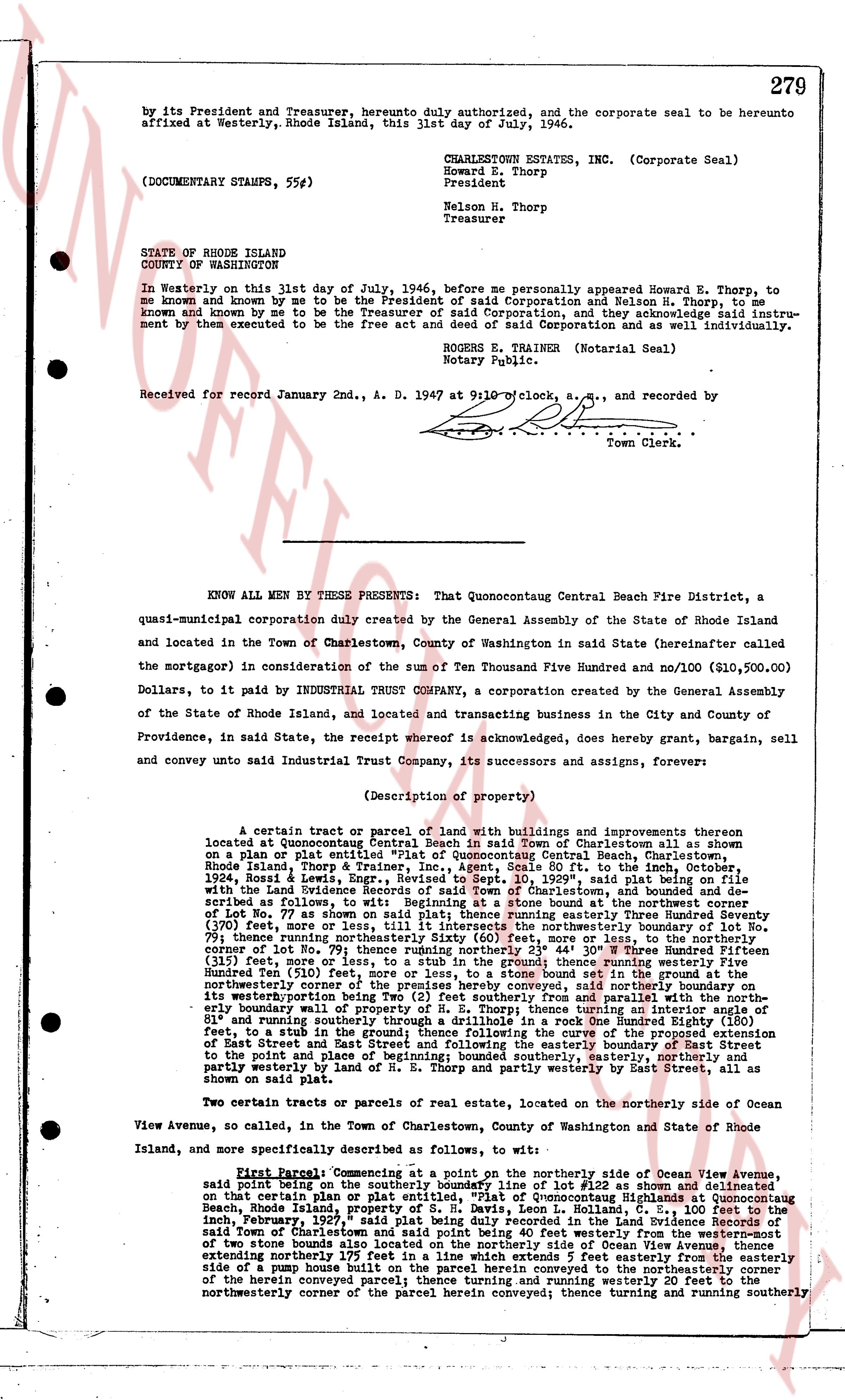
by its President and Treasurer, hereto duly authorized, and the corporate seal to be hereunto affixed at Westerly, Rhode Island, this 31st day of July, 1946.
CHARLESTOWN ESTATES, INC. (Corporate Seal)
Howard E. Thorp
President
Nelson H. Thorp
Treasurer
(DOCUMENTARY STAMPS, 55#)
STATE OF RHODE ISLAND
COUNTY OF WASHINGTON
In Westerly on this 31st day of July, 1946, before me personally appeared Howard E. Thorp, to me known and known by me to be the President of said Corporation and Nelson H. Thorp, to me known and known by me to be the Treasurer of said Corporation, and they acknowledge said instrument by them executed to be the free act and deed of said Corporation as well as their own individually.
ROGER E. TRAINER (Notarial Seal)
Notary Public.
Received for record January 2nd, A. D. 1947 at 9:10 o'clock, a.m., and recorded by
Town Clerk.
----
KNOW ALL MEN BY THESE PRESENTS: That Quonocutcong Central Beach Fire District, a quasi-municipal corporation duly created by the General Assembly of the State of Rhode Island and located in the Town of Charlestown, County of Washington in said State (hereinafter called the mortgagor) in consideration of the sum of Ten Thousand Five Hundred and no/100 ($10,500.00) Dollars, to it paid by INDUSTRIAL TRUST COMPANY, a corporation created by the General Assembly of the State of Rhode Island, and located and transacting business in the City and County of Providence, in said State, the receipt whereof is acknowledged, does hereby grant, bargain, sell and convey unto said Industrial Trust Company, its successors and assigns, forever:
(Description of property)
A certain tract or parcel of land with buildings and improvements thereon located at Quonocutcong Central Beach in said Town of Charlestown although as shown on a plan or plat entitled "Plat of Quonocutcong Central Beach, Charlestown, Rhode Island, Thorp & Trainer, Engineers" recorded in Book 20, page 70, in the town's records, 1924, Rossil & Lewis, Engrs., Revised to Sept 10, 1929, said plan being on file with the Town Land Evidence Recorder, and more or less as follows: the said tract of land as described as follows, to wit: Beginning at a stone found at the northwestern corner of Lot No. 77 as shown on said plan; thence running easterly Three Hundred Seventy Seven (377) feet, more or less, to the northeasterly corner of said Lot No. 77; thence running southerly 79 feet; thence running northeasterly Sixty (60) feet, more or less, to the northeasterly corner of Lot No. 78; thence running easterly One Hundred Twenty-Five (125) feet, more or less, to the southerly boundary of Lot No. 79; thence running southerly One Hundred Fifteen (115) feet, more or less, to a stub in the ground thence running westerly Five Hundred Twenty-One (521) feet, more or less, to the northwestern set in the ground; thence running northwesterly the premises hereby conveyed, said northerly boundary on the westerly boundary wall of property of H. E. Thorp; thence turning an interior angle of 81 and running easterly 100 feet to a stub in the ground; thence following the curve of the proposed Extension of East Street and running southeasterly to a rock found; thence running southeasterly 100 feet to a stub in the ground and point of beginning; bounded southerly, easterly, northerly and westerly by land of H. E. Thorp and partly westerly by East Street, all as shown on said plat.
Two certain tracts or parcels of real estate, located on the northerly side of Ocean View Avenue, so called, in the Town of Charlestown, County of Washington and State of Rhode Island, and more specifically described as follows, to wit:
First Parcel: Commencing at a point on the northerly side of Ocean View Avenue, said point being on the westerly boundary line of Lot No. 152 as shown on a plan or plat certain plan or plat entitled "Plat of Quonocutcong Central Beach at Quonocutcong Beach, Rhode Island, property of S. H. Davis, Leon L. Kohllan, C. E., 100 feet to the inch, February 1, 1927" recorded in the Land Evidence records of the Town of Charlestown, said Town of Charlestown and said point being 40 feet westerly from the western-most edge of two stone houses built on said Lot No. 152; thence running northerly 100 feet, extending northerly 175 feet in a line which extends 5 feet easterly from the easterly side edge of a pump house built on said parcel herein conveyed to the northeasterly corner of the herein conveyed parcel; thence running easterly to the easterly corner of Lot No. 152; thence running northwestly corner of the parcel herein conveyed; thence turning and running southerly
The page as recorded