The instrument's own words
page 1 · read by Gemma vision
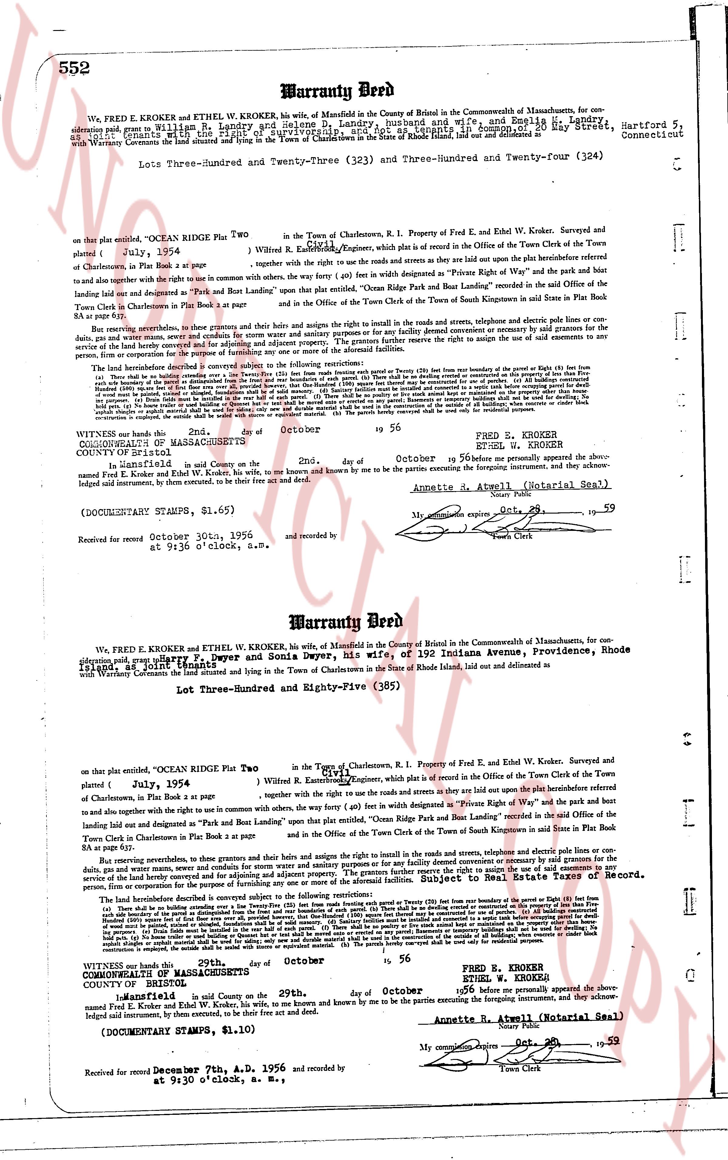
552 Warranty Deed
We, FRED E. KROKER and ETHEL W. KROKER, hs wife, of Mansfield in the County of Windham in the Commonwealth of Massachusetts, for consideration paid grant to William R. Landry and Selene P. Landry, husband and wife, and Emilia L. Landry, 8 May Street, Hartford 5, Connecticut (grants with the right of survivorship) their heirs and assigns forever, the land and premises now and then belonging to the Town of Charlestown in the State of Rhode Island, laid out and delineated in a Warranty Conveyance dated October 2nd day of October 1956
Lots Three-Hundred and Twenty-Three (323) and Three-Hundred and Twenty-four (324)
on that plat entitled "OCEAN RIDGE PLAT Two" in the Town of Charlestown, R. I. Property of Fred E. and Ethel W. Kroker. Surveyed and plated ( July, 1954 ) by Wilson R. Estabrook Engineer, which plat is a record filed in the Office of the Town Clerk of the Town of Charlestown in Book 2 at page 87 together with the right use and easements on the roads and streets as they are laid out upon the platinsertBeforeed hereto and to also together with the right use and easements on the roads and streets with the other party, the way forty (40) feet in width designated as "Private Right of Way" and the park and bathing land laid out and designated as "Park and Boat Landing" upon that plat entitled, "Ocean Ridge Park and Boat Landing" recorded in the said Office of the Town Clerk in Charlestown in Book 2 at page 87 and in the Office of the Town Clerk of the Town of South Kingstown in said State in Plat Book 4 at page 52.
But reserving nevertheless, to themselves and their grants and heirs the right and rights to use in the roads and streets, telephone and electric poles and telephone lines or conduits, gas, water and manure sewers, and everything for convey and adjusting an adjacent property. The grantors further reserve the right to sign the quit claim and any other documents necessary for the purpose of clearing title to the above described property. This restriction shall run with the land.
(a) There shall be no building erected over the Way (1) from the house boundaries of the parcels (2) (etc etc) from the house boundaries of the parcels (8) (etc) from the house boundaries of the parcels (8) (etc) from the house boundaries of the parcels (8) (etc) from the house boundaries of the parcels (8) (etc) from the house boundaries of the parcels (8) (etc) from the house boundaries of the parcels (8) (etc) from the house boundaries of the parcels (8) (etc) from the house boundaries of the parcels (8) (etc). (b) All buildings constructed on the lots shall be residential dwellings only. (c) No business of any kind shall be conducted on the lots except that of the resident owner. (d) No livestock shall be kept on the lots. (e) No nuisance of any kind shall be permitted on the lots. (f) No garbage or refuse shall be burned in the open air. (g) No unsightly objects shall be placed on the lots. (h) No fences shall be erected in the front of the lots. (i) Only domestic animals shall be kept on the lots. (j) No poultry shall be raised or livestock animals kept on the lots, provided that such buildings shall not be used for dwelling. (k) No building shall be erected within twenty (20) feet of the side limits of the lots. (l) No building shall be erected within thirty (30) feet of the front limit of the lots. (m) No building shall be erected within twenty (20) feet of the rear limit of the lots. (n) No accessory or tributary buildings shall be used for dwelling. (o) No building shall be erected without first obtaining the approval of the association. (p) No change in the use of the lots shall be made without the approval of the association. (q) No structure shall be erected, installed or situated without an express agreement on suitable site. (r) The parcels hereby conveyed shall be used only for residential purposes.
Witness our hands the 2nd day of October 19 56
COMMONWEALTH OF MASSACHUSETTS
COUNTY OF ESSEX
In Mansfield and signed to me the 2nd day of October 1956 personally appeared the above named Fred E. Kroker and Ethel W. Kroker, hs wife, to me known and known by me to be the persons executing the foregoing instrument, and they acknowledged signed instrument, by their consent, to be their free act and deed.
Annette R. Atwell (Notarial Seal)
(DOCUMENTARY STAMPS, $1.65)
Received for record October 30th, 1956 and recorded by
at 9:36 o'clock, a.M. My commission expires Oct. 29, 1959
Town's Clerk
----
Warranty Deed
We, FRED E. KROKER and ETHEL W. KROKER, hs wife, of Mansfield in the County of Windham in the Commonwealth of Massachusetts, for consideration paid, grant Harry F. Dwyer and Sonia Dwyer, hs wife, of 192 Indiana Avenue, Providence, Rhode Island, their heirs and assigns forever, the land and premises now and then belonging to the Town of Charlestown in the State of Rhode Island, laid out and delineated as
Lot Three-Hundred and Eighty-Five (385)
on that plat entitled, "OCEAN RIDGE PLAT Two plotted July, 1954 ) by Wilson R. Estabrook Engineer, which plat is a record filed in the Office of the Town Clerk of the Town of Charlestown in Book 2 at page 87 together with the roads and streets as they are laid out upon the platinsertBeforeed hereto and to also together with the right use and easements on the roads and streets with the other party, the way forty (40) feet in width designated as "Private Right of Way" and the park and bathing land laid out and designated as "Park and Boat Landing" upon that plat entitled, "Ocean Ridge Park and Boat Landing" recorded in the said Office of the Town Clerk in Charlestown in Book 2 at page 87 and in the Office of the Town Clerk of the Town of South Kingstown in said State in Plat Book 4 at page 52.
But reserving nevertheless, to themselves and their grants and heirs the right and rights to use in the roads and streets, telephone and electric poles and telephone lines or conduits, gas, water and manure sewers, and everything for convey and adjusting an adjacent property. The grantors further reserve the right to sign the quit claim and any other documents necessary for the purpose of clearing title to the above described property. To Be Filed In The Land Taxes Of Record. person, firm or corporation for the purpose of the following restrictions:
The following restrictions shall apply to and be binding upon the owner and successors to the following restrictions:
(a) There shall be no building erected over the Way (1) from the house boundaries of the parcels (2) (etc etc) from the house boundaries of the parcels (8) (etc) from the house boundaries of the parcels (8) (etc) from the house boundaries of the parcels (8) (etc) from the house boundaries of the parcels (8) (etc) from the house boundaries of the parcels (8) (etc) from the house boundaries of the parcels (8) (etc) from the house boundaries of the parcels (8) (etc) from the house boundaries of the parcels (8) (etc). (b) All buildings constructed on the lots shall be residential dwellings only. (c) No business of any kind shall be conducted on the lots except that of the resident owner. (d) No livestock shall be kept on the lots. (e) No nuisance of any kind shall be permitted on the lots. (f) No garbage or refuse shall be burned in the open air. (g) No unsightly objects shall be placed on the lots. (h) No fences shall be erected in the front of the lots. (i) Only domestic animals shall be kept on the lots. (j) No poultry shall be raised or livestock animals kept on the lots, provided that such buildings shall not be used for dwelling. (k) No building shall be erected within twenty (20) feet of the side limits of the lots. (l) No building shall be erected within thirty (30) feet of the front limit of the lots. (m) No building shall be erected within twenty (20) feet of the rear limit of the lots. (n) No accessory or tributary buildings shall be used for dwelling. (o) No building shall be erected without first obtaining the approval of the association. (p) No change in the use of the lots shall be made without the approval of the association. (q) No structure shall be erected, installed or situated without an express agreement on suitable site. (r) The parcels hereby conveyed shall be used only for residential purposes.
Witness our hands the 29th day of October 19 56
COMMONWEALTH OF MASSACHUSETTS
COUNTY OF ESSEX
In Mansfield and signed to me the 29th day of October 1956 personally appeared the above named Fred E. Kroker and Ethel W. Kroker, hs wife, to me known and known by me to be the persons executing the foregoing instrument, and they acknowledged signed instrument, by their consent, to be their free act and deed.
Annette R. Atwell (Notarial Seal)
(DOCUMENTARY STAMPS, $1.10)
My commission expires Oct. 29, 1959
Town Clerk
Received for record December 7th, A.D. 1956 and recorded by
at 9:30 o'clock, a. M.
The page as recorded