The Deed Walker · From Ninigret · Charlestown, Rhode Island land evidence, 1738 to today
Trail: 10510 › 6897 › 42@28/657

5/7/1942 · LEASE · book 28 page 657 doc 42@28/657

From KELLEY HUBERT L, KELLEY JOHN P life, WALSH DOROTHEA D
To WALSH DOROTHEA D, KELLEY JOHN P life, KELLEY HUBERT L
Premises none · Portion of land bounded by Atlantic Ocean and Morganses' land (Charlestown)
Index description SEE DOC
Also on this page: LEASE BURDICK EDWARD E; KELLEY HUBERT L

Back — where this land came from

deed Anna B. Kenyon book 18 p 84 Charlestown
“conveyed by deed of Anna B. Kenyon to this Mortgagor”
◀ Follow back 1914 · DEED · KENYON ANNA H; KENYON LEWIS L → BURDICK MYRTIE T · book 18 p 84
read by: gemma

The grantor's earlier acquisitions, by name — the man, not necessarily this land

◀ 1942 · LEASE · KELLEY HUBERT L; BURDICK EDWARD E → BURDICK EDWARD E; KELLEY HUBERT L · book 28 p 657
◀ 1941 · LEASE · KELLEY HUBERT L; BURDICK EDWARD E → BURDICK EDWARD E; KELLEY HUBERT L · book 28 p 431
◀ 1941 · DEED · WAKEFIELD TRUST COMPANY → KELLEY HUBERT L · book 28 p 566
◀ 1941 · DEED · WAKEFIELD TRUST COMPANY → KELLEY HUBERT L · book 28 p 567
◀ 1939 · DEED · WALSH JAMES A → WALSH DOROTHEA D · book 27 p 581

Forward — where this land went

The grantee's later conveyances, by name — the man, not necessarily this land; the one that cites this deed as its source is the land

▶ 1942 · LEASE · KELLEY HUBERT L; BURDICK EDWARD E → BURDICK EDWARD E; KELLEY HUBERT L · book 28 p 657
▶ 1945 · RELEASE STANDARD · KELLEY HUBERT L; KELLEY JOHN P; WALSH DOROTHEA D → WALSH DOROTHEA D; KELLEY JOHN P; KELLEY HUBERT L · book 28 p 658
▶ 1946 · SECURITY NOTICE OF LIEN · WALSH DOROTHEA D; WALSH JAMES A → FARMERS PRODUCTION CREDIT ASSOC · book 0 p 0
▶ 1946 · LEASE · WALSH DOROTHEA D; WALSH JAMES A → WALSH JAMES A; WALSH DOROTHEA D · book 30 p 43
▶ 1946 · LEASE · ADAMS VANAMIE; WALSH DOROTHEA D → WALSH DOROTHEA D; ADAMS VANAMIE · book 30 p 44
▶ 1946 · MORTGAGE · WALSH DOROTHEA D; WALSH JAMES A → BARISH SAM; BARISH & MICKELSON; MICKELSON HENRY · book 30 p 45
▶ 1948 · DEED · WALSH DOROTHEA D; WALSH JAMES A → CRANDALL VERICE A · book 31 p 338
▶ 1949 · AGREEMENT · WALSH DOROTHEA D; WALSH JAMES A → NARRAGANSETT ELECTRIC COMPANY · book 31 p 457
▶ 1949 · DEED · WALSH DOROTHEA D; WALSH JAMES A → PENNELL ALEXINE W; PENNELL JOHN · book 31 p 596
▶ 1950 · MORTGAGE · KELLEY HUBERT L → WAKEFIELD TRUST CO · book 32 p 77
▶ 1950 · MORTGAGE · KELLEY EVA B M; KELLEY HUBERT L → WAKEFIELD TRUST CO · book 32 p 79
▶ 1950 · DEED · WALSH DOROTHEA D; WALSH JAMES A → KULZ GEORGE A · book 32 p 144
▶ 1950 · DEED · KULZ GEORGE A; WALSH DOROTHEA D; THORNTON JAMES D COM; THORNTON JAMES → WALSH DOROTHEA D · book 32 p 350
▶ 1950 · MORTGAGE · WALSH DOROTHEA D; WALSH JAMES A → PROVIDENCE NATIONAL BANK · book 32 p 351
▶ 1951 · MORTGAGE · KELLEY EVA B; KELLEY HUBERT L → PROVIDENCE UNION NATIONAL BANK AND TRUST CO · book 32 p 501
▶ 1952 · LEASE · STORIN FRANK I; STORIN HELEN W; WALSH DOROTHEA D → WALSH DOROTHEA D; STORIN HELEN W; STORIN FRANK I · book 33 p 42

The instrument's own words

page 1 · read by Gemma vision
636 KNOW ALL MEN BY THESE PRESENTS, that I, MYRTLE T. BURDICK, widow, of the City of Stamford, State of Connecticut, for consideration paid, grant or convey to WALTER L. PERRIN and CLIPFORD S. PERRIN, both of the Town of Hopkinton, County of Washington and State of Rhode Island with MORTGAGE COVENANTS, to secure the payment of Three Hundred eighty-five and 50/100 Dollars in six months with interest at Six (6) per centum, per annum, payable semi- annually in advance as provided in a certain negotiable promissory note of even date hereby- with: that certain real estate situate in Charlestown, County of Washington, in the State of Rhode Island, and described as follows: beginning at the Mean Highwater Line of the Atlantic Ocean at the southeasterly corner of the premises hereby conveyed and at the south- westerly corner of land of all the heirs of the above named parties hereinafter named, bounded easterly by said Morganses' land, a distance of Two Hundred Forty (240) feet, north eastly by the southeasterly corner of the highway bounding said premises; thence westerly, bounded northerly by land, more or less, or formerly, of Emma R. Hopson, a distance of Two Hundred Forty (240) feet, thence southerly, corner of the hereby conveyed tract, and the northeasterly corner of land of Cora S. booming thence southerly, bounded westerly by said Morganses' land, a distance of the Boundary Line of the Mean Highwater Line of the Atlantic High- water Line, and the southeasterly corner of the hereby conveyed premises thence, bounded southerly by the Mean Highwater Line of the Atlantic Ocean, a distance of Forty-five (45) feet, to the point and place of beginning or otherwise however other- wise the same may be bounded and described. Also, the one-sixteenth (1/16) undivided interest in a street running through said described tract from land, now or formerly, of Samuel F. Babcock and others, to the Atlantic Ocean. The above-described premises are a portion of the premises conveyed by deed of Anna B. Kenyon to this Mortgagor, said deed bearing date of June 11th, 1914, and recorded in the town's land evidence books, said Town of Charlestown, in Book No. 18, Pages 84, 85 and 86. Reference to said deed and the records thereof, together with all the restrictions and reservations contained therein, is hereby made and made the same a part of this instrument. This mortgage is subject to prior mortgage to those Mortgagees of record in the Land Evidence Records of said Charlestown, Book No. 26, at Page 31. This mortgage is made upon the STATUTORY CONDITION and with the STATUTORY POWER OF SALE. WITNESS my hand this 2nd day of March, 1937. MYRTLE T. BURDICK. Tessie Hurley Elizabeth B. Pickett STATE OF CONN. ) County of Fairfield) In Stamford on the 2nd day of March, 1937 before me personally appeared Myrtie T. Burdick, to me known and known by me to be the party executing the foregoing instru- ment, and she acknowledged said instrument, by her executed, to be her free act and deed. TESSIE HURLEY Notary Public. Received for record March 6th, A. D. 1937 at 1:00 o'clock, p. m., and recorded by [?] Town Clerk

The page as recorded
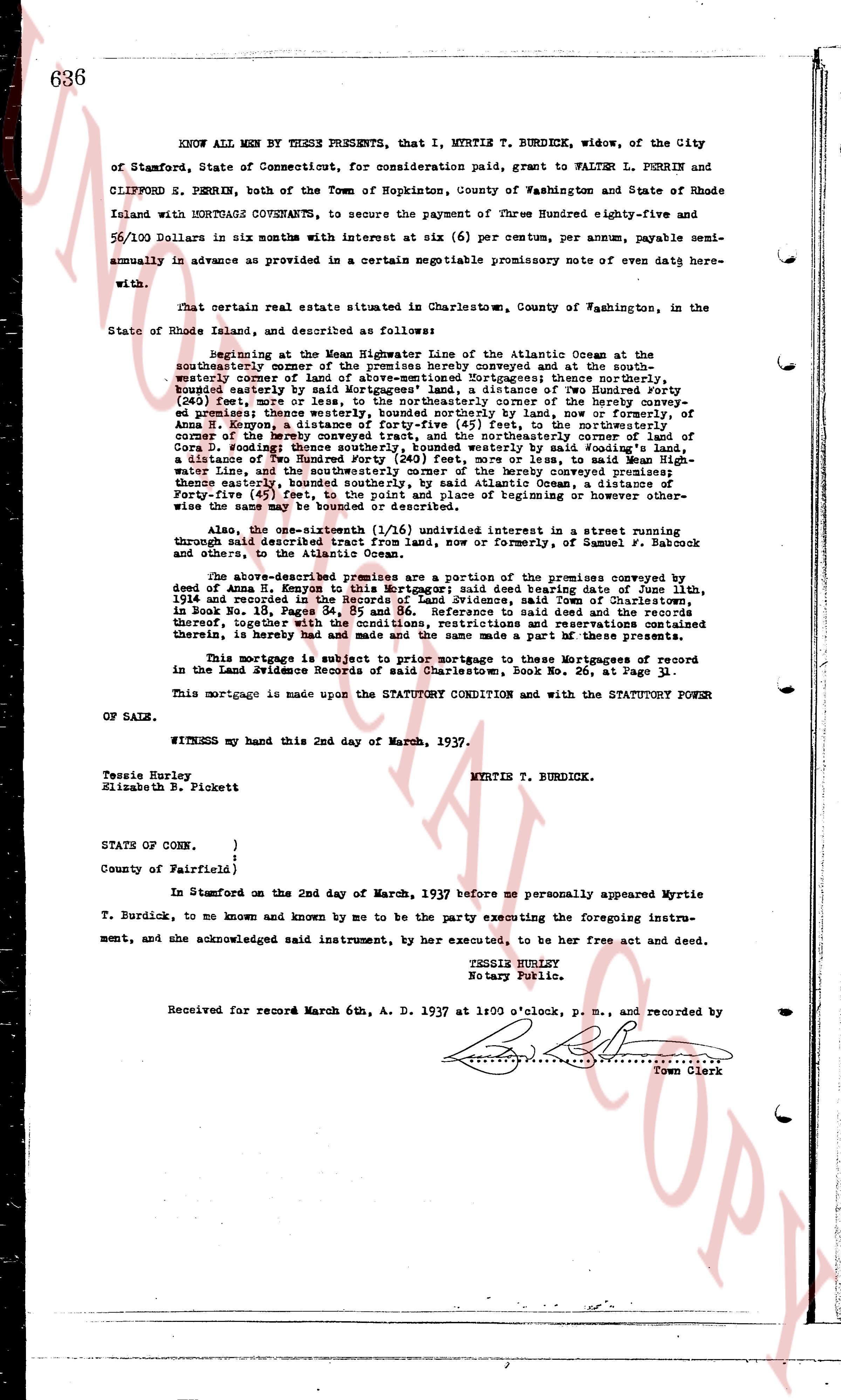
page 1

deed_walker_v1.9_2026-10-10 · the index is the town's own (i2l.uslandrecords.com); transcripts, chains and the assessor's cards are the Perry Machine's reading of it. Where the record we hold runs out, the page says so.