The instrument's own words
page 1 · read by Gemma vision
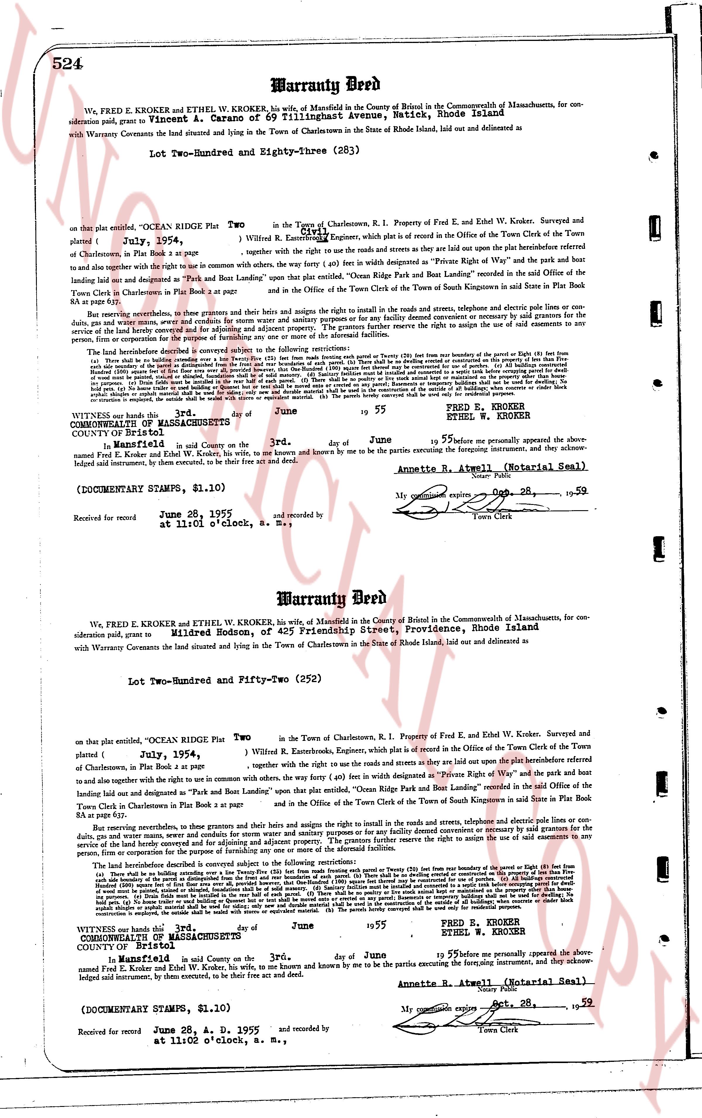
524 Warranty Deed
We, FRED E KROKER and ETHEL W KROKER, his wife, of Mansfield in the County of Bristol in the Commonwealth of Massachusetts, for consideration paid, grant to Vincent A. Carano of 69 Tillingshatch Avenue, Natick, Rhode Island
with Warranty Covenants the land situated and lying in the Town of Charlestown in the State of Rhode Island, laid out and delivered as delimited
Lot Two-Hundred and Eighty-three (283)
on that plat entitled, "OCEAN RIDGE Plat Two in the Town of Charlestown, R.I. Property of Fred E. and Ethel W. Kroker. Surveyed and
platted [?] July, 1954 together with the right to use the roads and streets as they are laid out upon the platinsertBeforehand referred
of Charlestown, in Plat Book 1, page 5 to,
and to also have and enjoy the right to use in common with others, the way (forty (40) feet in width) designated as "Private Right of Way" the park and the boat
landing laid out and designated as "Park and Boat Landing" upon that plat entitled, "Ocean Ridge Private Park and Boat Landing" recorded in the Said Office of the
Town Clerk in Charlestown in Plat Book 1 at page 2 and in the Office of the Town Clerk of the Town of South Kingstown in said State in Plat Book
8 at page 4.
Both reserving nevertheless, for themselves and their heirs and assigns the right to install in the roads and streets, telephone and electric poles or concrete poles or
conduits, gas and water pipes and sewers. The grantors further reserve the right to maintain and construct or improve any road, street or way for the purpose of
service of the land hereby conveyed and for adjoining and adjacent property. The grantors further reserve the right to assign the use of said easements to any
person, firm or corporation for the purpose of the same.
The following restrictions are hereby conveyed and subject to the following restrictions:
(a) There shall be no building constructed upon any lot (except a garage or shed) within fifty (50) feet from the boundary of the Parcel or eighty (80) feet from
the boundary of the park. (b) No building shall be constructed from the distance of the park and the boat landing. (c) No building shall be constructed within twenty (20)
side boundary of the parcel at any diagonal distance from the front and rear of such parcels. (d) There shall be no building erected or used for dwelling, be
it residential or commercial, other than a single family dwelling. (e) No building shall be used for any purpose other than a single family dwelling. (f) No
building shall be constructed on any lot which is less than 10,000 square feet. (g) No building shall be constructed on any lot which is less than 60 feet wide.
(h) No building shall be constructed on any lot which is less than 100 feet deep. (i) No building shall be constructed on any lot which is less than 60 feet wide
on property. (j) No fence shall be erected in the rear half of such parcels. (k) There shall be no paving or lot surface other than a driveway or motor boat
construction is employed, the outside shall be sided with cedar or similar material. (l) The porch brewery constructed shall be used only for residential purposes.
WITNESS our hand this 3rd day of June 1955 FRED E. KROKER
ETHEL W. KROKER
STATE OF MASSACHUSETTS
COUNTY OF Bristol
On this 3rd day of June 1955 before me personally appeared the above-
named Fred E. Kroker and Ethel W. Kroker, his wife, to me known and known by me to be the parties executing the foregoing instrument, and they acknow-
ledged signed instrument, by them executed, to be their free act and deed.
Annette R. Atwell (Notarial Seal)
My commission expires Oct. 28, 1959
(DOCUMENTARY STAMPS, $1.10) Town Clerk
Received for record June 28, 1955 and recorded by [?]
----
Warranty Deed
We, FRED E KROKER and ETHEL W KROKER, his wife, of Mansfield in the County of Bristol in the Commonwealth of Massachusetts, for con-
sideration paid, grant to Mildred Bodson, of 425 Friendship Street, Providence, Rhode Island
with Warranty Covenants the land situated and lying in the Town of Charlestown in the State of Rhode Island, laid out and delivered as delimited
Lot Two-Hundred and Fifty-two (252)
on that plat entitled, "OCEAN RIDGE Plat Two in the Town of Charlestown, R.I. Property of Fred E. and Ethel W. Kroker. Surveyed and
platted [?] July, 1954 recorded in the Office of the Town Clerk of the Town of
of Charlestown, in Plat Book 1, page 5 together with the right to use the roads and streets as they are laid out upon the platinsertBeforehand referred
to, and to also have and enjoy the right to use in common with others, the way (forty (40) feet in width) designated as "Private Right of Way" the park and the boat
landing laid out and designated as "Park and Boat Landing" upon that plat entitled, "Ocean Ridge Private Park and Boat Landing" recorded in the said Office of the
Town Clerk in Charlestown in Plat Book 1 at page 2 and in the Office of the Town Clerk of the Town of South Kingstown in said State in Plat Book
8 at page 4.
Both reserving nevertheless, for themselves and their heirs and assigns the right to install in the roads and streets, telephone and electric poles or concrete poles or
conduits, gas and water pipes and sewers. The grantors further reserve the right to maintain and construct or improve any road, street or way for the purpose of
service of the land hereby conveyed and for adjoining and adjacent property. The grantors further reserve the right to assign the use of said easements to any
person, firm or corporation for the purpose of the same.
The following restrictions are hereby conveyed and subject to the following restrictions:
(a) There shall be no building constructed upon any lot (except a garage or shed) within fifty (50) feet from the boundary of the Parcel or eighty (80) feet from
the boundary of the park. (b) No building shall be constructed from the distance of the park and the boat landing. (c) No building shall be constructed within twenty (20)
side boundary of the parcel at any diagonal distance from the front and rear of such parcels. (d) There shall be no building erected or used for dwelling, be
it residential or commercial, other than a single family dwelling. (e) No building shall be used for any purpose other than a single family dwelling. (f) No
building shall be constructed on any lot which is less than 10,000 square feet. (g) No building shall be constructed on any lot which is less than 60 feet wide.
(h) No building shall be constructed on any lot which is less than 100 feet deep. (i) No building shall be constructed on any lot which is less than 60 feet wide
on property. (j) No fence shall be erected in the rear half of such parcels. (k) There shall be no paving or lot surface other than a driveway or motor boat
construction is employed, the outside shall be sided with cedar or similar material. (l) The porch brewery constructed shall be used only for residential purposes.
WITNESS our hand this 3rd day of June 1955 FRED E. KROKER
ETHEL W. KROKER
STATE OF MASSACHUSETTS
COUNTY OF Bristol
On this 3rd day of June 1955 before me personally appeared the above-
named Fred E. Kroker and Ethel W. Kroker, his wife, to me known and known by me to be the parties executing the foregoing instrument, and they acknow-
ledged signed instrument, by them executed, to be their free act and deed.
Annette R. Atwell (Notarial Seal)
My commission expires Oct. 28, 1959
(DOCUMENTARY STAMPS, $1.10) Town Clerk
Received for record June 28, A. D. 1955 and recorded by [?]
The page as recorded