The instrument's own words
page 1 · read by Gemma vision
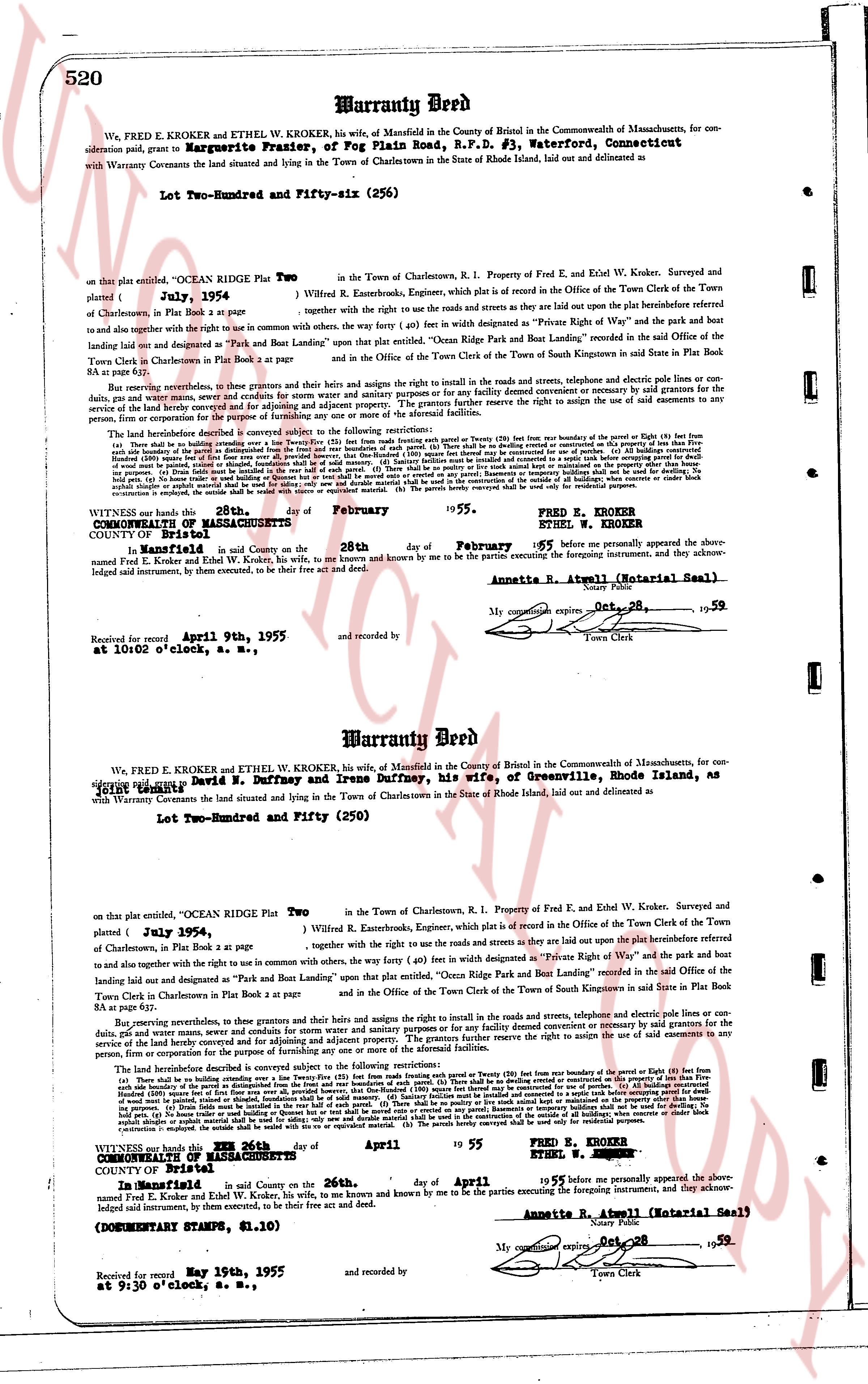
520 Warranty Deed
We, FRED E. KROKER and ETHEL W. KROKER, his wife, of Mansfield, in the County of Windham in the Commonwealth of Massachusetts, consideration said, grant to Marguerite Frazier, of Fog Plain Road, R.F.D. #3, Waterford, Connecticut
with Warranty Covenants the land situated and lying in the Town of Charlestown in the state of Rhode Island, laid out and delineated as
Lot Two-Hundred and Fifty-six (256)
on that plat entitled, “OCEAN Ridge Plat Two” plotted { July, 1954 } in the Town of Charlestown, R.I. Property of Fred E. and Ethel W. Kroker, Surveyed and plotted { July, 1954 } by Willard E. Butterworth, Engineer, which plat is on file in the Office of the Town Clerk of the Town of Charlestown, R.I. Book plat A page 8 together with the right to use the roads and streets as they are laid out upon the plat beforehand referred hereto and to also together with the right to use in common with others, the way (forty (40) feet in width designated as “Private Right of Way” and the park lot being laid out and designated as “Park and Boat Landing” upon that plat entitled, “Ocean Ridge Park and Boat Landing” recorded in the Said office of the Town Clerk in Charlestown Book plat A page 8 and in the Office of the Town Clerk of the Town of South Kingstown in said State in Plat Book B page 84 as per plat.
But reserving nevertheless, to themselves and their heirs and assigns the right and title to the roads in the usual sense, and telephone and electric pole lines or conduits for such purposes, and any other utility easements now existing or hereafter constructed or agreed by covenant or agreement to said grants for the service of the land hereby conveyed and for adjoining and adjacent property. The grantors further reserve the right to assign the use of said easements to any person, firm or corporation.
The land heretofore described is conveyed subject to the following restrictions: the
(a) No building shall be erected on any lot except within the building line (twenty (20) feet from any boundary of the parcel or Eighty (80) feet from any side boundary of the parcel as distinguished from the front and rear boundaries of such parcel) unless the authorization of both parties of the records of this instrument be given. (b) All buildings constructed on any lot shall be designed and built so as to harmonize with the general character of the development. (c) No building shall be erected on any lot except in accordance with the minimum requirements as to size, shape and setback from the boundary lines of the lot (twenty (20) feet) except that no building shall be erected on any lot smaller than 10,000 square feet without the written consent of the Grantor. (d) No building shall be used for any purpose other than as a single family residence. (e) No business of any kind shall be carried on or permitted by easement or franchise shall be used or for docking, No commercial fishing operations. (f) Dwellings must be located in the east half of the parcel. (g) Trees shall be maintained in the east half of the parcel. (h) The parcels hereby conveyed shall not be subdivided. (i) No fence shall be erected on any lot except as approved by the Grantor. (j) No animal shall be kept on any lot except as approved by the Grantor. (k) No structure shall be erected on any lot except as approved by the Grantor. (l) No excavation or emplantation, is eligible outside the wall shall be treated with cement or reinforced with iron. (m) The parcels hereby conveyed shall be used only for residential purposes.
WITNESS our hands this 28th day of February 1955. FRED E. KROKER
ETHEL W. KROKER
COMMONWEALTH OF MASSACHUSETTS
COUNTY OF Windham ss.
In Mansfield, in said County on the 28th day of February '55 before me personally appeared the above named Fred E. Kroker and Ethel W. Kroker, his wife, to me known and by me to be the parties executing the foregoing instrument, and they acknowledged said instrument, by their examents, to be their free act and deed.
Annette R. Atwell (Notarial Seal)
My commission expires Oct 28, 1959
Town Clerk
Received and recorded April 9th, 1955, and recorded by
at 10:02 o'clock, a. M., R. S.
----
Warranty Deed
We, FRED E. KROKER and ETHEL W. KROKER, his wife, of Mansfield in the Commonwealth of Massachusetts, for consideration said, grant to David N. Duffney and Irene Duffney, his wife, of Greenville, Rhode Island, as tenants by the entirety
with Warranty Covenants the land situated and lying in the Town of Charlestown in the state of Rhode Island, laid out and delineated as
Lot Two-Hundred and Fifty (250)
on that plat entitled, “OCEAN Ridge Plat Two plotted { July, 1954 } in the Town of Charlestown, R. I. Property of Fred E. and Ethel W. Kroker, Surveyed and plotted { July, 1954 } by Willard E. Butterworth, Engineer, which plat is on file in the Office of the Town Clerk of the Town of Charlestown, R. I. Book plat A page 8 together with the right to use the roads and streets as they are laid out upon the plat beforehand referred hereto and to also together with the right to use in common with others, the way (forty (40) feet in width designated as “Private Right of Way” and the park lot being laid out and designated as “Park and Boat Landing” upon that plat entitled, “Ocean Ridge Park and Boat Landing” recorded in the Said office of the Town Clerk in Charlestown Book plat A page 8 and in the Office of the Town Clerk of the Town of South Kingstown in said State in Plat Book B page 84 as per plat.
But reserving nevertheless, to themselves and their heirs and assigns the right and title to the roads in the usual sense, and telephone and electric pole lines or conduits for such purposes, and any other utility easements now existing or hereafter constructed or agreed by covenant or agreement to said grants for the service of the land hereby conveyed and for adjoining and adjacent property. The grantors further reserve the right to assign the use of said easements to any person, firm or corporation.
The land heretofore described is conveyed subject to the following restrictions: the
(a) No building shall be erected on any lot except within the building line (twenty (20) feet from any boundary of the parcel or Eighty (80) feet from any side boundary of the parcel as distinguished from the front and rear boundaries of such parcel) unless the authorization of both parties of the records of this instrument be given. (b) All buildings constructed on any lot shall be designed and built so as to harmonize with the general character of the development. (c) No building shall be erected on any lot except in accordance with the minimum requirements as to size, shape and setback from the boundary lines of the lot (twenty (20) feet) except that no building shall be erected on any lot smaller than 10,000 square feet without the written consent of the Grantor. (d) No building shall be used for any purpose other than as a single family residence. (e) No business of any kind shall be carried on or permitted by easement or franchise shall be used or for docking, No commercial fishing operations. (f) Dwellings must be located in the east half of the parcel. (g) Trees shall be maintained in the east half of the parcel. (h) The parcels hereby conveyed shall not be subdivided. (i) No fence shall be erected on any lot except as approved by the Grantor. (j) No animal shall be kept on any lot except as approved by the Grantor. (k) No structure shall be erected on any lot except as approved by the Grantor. (l) No excavation or emplantation, is eligible outside the wall shall be treated with cement or reinforced with iron. (m) The parcels hereby conveyed shall be used only for residential purposes.
WITNESS our hands this 19th day of April 1955 FRED E. KROKER
ETHEL W. KROKER
COMMONWEALTH OF MASSACHUSETTS
COUNTY OF Windham ss.
In Mansfield, in said County on the 26th day of April 1955 before me personally appeared the above named Fred E. Kroker and Ethel W. Kroker, his wife, to me known and by me to be the parties executing the foregoing instrument, and they acknowledged said instrument, by their examsents, to be their free act and deed.
(Documentary Stamps, $1.10)
Annette R. Atwell (Notarial Seal)
My commission expires Oct 28, 1959
Town Clerk
Received and recorded May 19th, 1955, and recorded by
at 9:30 o'clock, a. M., R. S.
The page as recorded