The instrument's own words
page 1 · read by Gemma vision
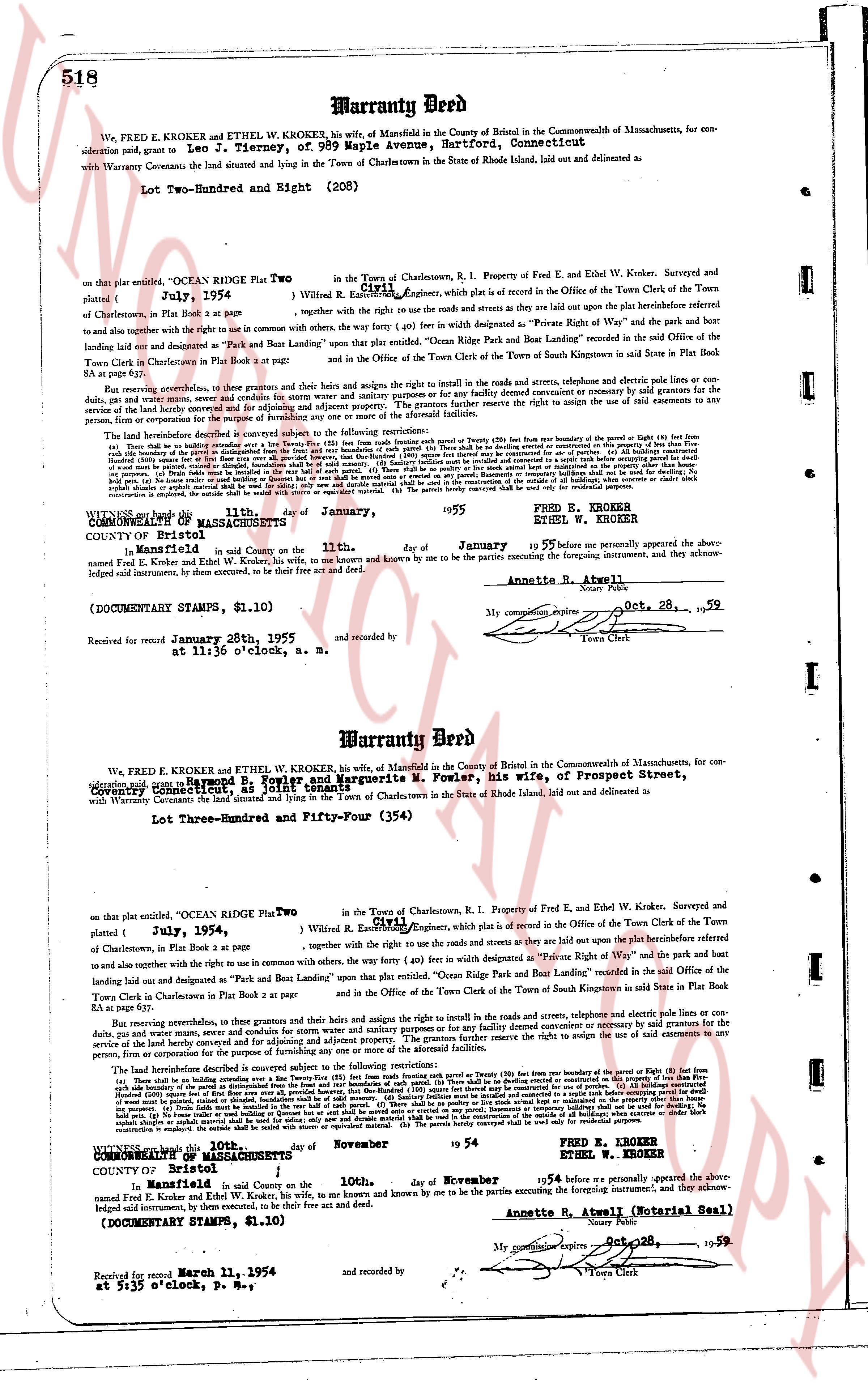
518 Warranty Deed
We, FRED E. KROKER and ETHEL W. KROKERS, his wife, of Mansfield in the County of Bristol in the Commonwealth of Massachusetts, for consideration paid, grant to Leo J. Tierney, of 989 Maple Avenue, Hartford, Connecticut
with Warranty Conveyance the land situated and lying in the Town of Charlestown in the State of Rhode Island, laid out and delineated as
Lot Two-Hundred and Eight (208)
on that plat entitled, "OCEAN RIDGE Plat Two" filed July 1954, written by R. Lowell C. [?] Engineer, which plat is a record in the Office of the Town Clerk of the Town of Charlestown, in Plat Book 1 at page 34, together with the right to use the roads & streets and crowns as they now lie up to the plat boundaries referred to and also assigning the right to make common use with others, the way (forty ft.) in each line designated as "Private Right of Way" the park and the bust landing laid out and designated as "Park and Boat Landing" upon that plat entitled "Ocean Ridge Park and Boat Landing" recorded in the said Office of the Town Clerk in Charlestown in Plat Book 1 at page 34 and in the Office of the Town Clerk of the Town of South Kingstown in said State in Plat Book 54 at page 71.
Reserving nevertheless, in these grants and conveyances, the rights and heirs assigns to the right in the roads and streets, telephone and electric pole lines cut through the property, and any other easements existing on the property prior to this conveyance or necessary for the construction or maintenance of such utilities, including but not limited to the right of ingress and egress over and across the property for servicing and adjusting adjacent properties. The grantors further reserve the right to assign the use of said easements to any persons, corporation or entity performing the above purposes.
The lot hereinabove described is subject conveyed subject to the following restrictions:
(a) The lot shall be used exclusively for residential purposes (i.e. one single family dwelling per lot) (b) No building may be erected on the Property (or part thereof) less than forty (40) feet from the boundary of the Parcel (or part thereof) (c) All buildings constructed on the Property shall be set back from the side boundaries of the Property a distance equal to one half of the width of the Property (d) No building shall be erected on the Property more than twenty five (25) feet from the rear boundary of the Property (e) No building shall be erected on the Property unless it is designed for use as a residence (f) No building shall be used for commercial purposes (g) All buildings constructed on the Property shall be built to a standard of quality consistent with the character of the neighborhood (h) No building shall be used for the purpose of storing boats, trailers, campers, automobiles etc. except in a garage specifically designed for such purpose (i) No fences shall be installed in the front half of such property (j) There shall be no pivots or posts for vines or trellises in the front yard (k) No antennas shall be erected on the Property unless they are located in the rear yard (l) No signs shall be placed on the Property except for the purpose of identifying the resident (m) No billboards or sales shelters shall be built or used for selling, advertising or promoting any business (n) No livestock shall be kept on the Property (o) No machinery or equipment shall be stored on the Property except in a garage enclosed by walls (p) No debris shall be stored or stockpiled anywhere on the property (q) The parcels hereby conveyed shall be used only for residential purposes.
WITNESS our hands this 21st day of January, 1955
COUNTY OF Bristol
STATE OF MASSACHUSETTS
Signed and sealed in said County on the 21st day of January 1955 before me personally appeared the above named Fred E. Kroker and Ethel W. Krokers, his wife, to me known by me to be the parties executing the foregoing instrument; and they acknowledged said instrument, by them executed, to be their free act and deed.
(DOCUMENTARY STAMPS, $1.10)
Received for record January 28th, 1955 at 11:35 o'clock, a. m.
FRED E. KROKER
ETHEL W. KROKER
Annette R. Atwell
My commission expires Oct 28, 1959
Town Clerk
and recorded by
----
Warranty Deed
We, FRED E. KROKER and ETHEL W. KROKER, his wife, of Mansfield in the County of Bristol in the Commonwealth of Massachusetts, for consideration paid, grant to Raymond B. Fowler and Marguerite M. Fowler, his wife, of Prospect Street, Providence, Rhode Island
with Warranty Conveyance the land situated and lying in the Town of Charlestown in the State of Rhode Island, laid out and delineated as
Lot Three-Hundred and Fifty-Four (354)
on that plat entitled, "OCEAN RIDGE Plat Two" filed July 1954, written by R. Lowell C. [?] Engineer, which plat is a record in the Office of the Town Clerk of the Town of Charlestown, in Plat Book 1 at page 34, together with the right to use the roads & streets and crowns as they now lie up to the plat boundaries referred to and also assigning the right to make common use with others, the way (forty ft.) in each line designated as "Private Right of Way" the park and the bust landing laid out and designated as "Park and Boat Landing" upon that plat entitled "Ocean Ridge Park and Boat Landing" recorded in the said Office of the Town Clerk in Charlestown in Plat Book 1 at page 34 and in the Office of the Town Clerk of the Town of South Kingstown in said State in Plat Book 54 at page 71.
Reserving nevertheless, in these grants and conveyances, the rights and heirs assigns to the right in the roads and streets, telephone and electric pole lines cut through the property, and any other easements existing on the property prior to this conveyance or necessary for the construction or maintenance of such utilities, including but not limited to the right of ingress and egress over and across the property for servicing and adjusting adjacent properties. The grantors further reserve the right to assign the use of said easements to any persons, corporation or entity performing the above purposes.
The lot hereinabove described is subject conveyed subject to the following restrictions:
(a) The lot shall be used exclusively for residential purposes (i.e. one single family dwelling per lot) (b) No building may be erected on the Property (or part thereof) less than forty (40) feet from the boundary of the Parcel (or part thereof) (c) All buildings constructed on the Property shall be set back from the side boundaries of the Property a distance equal to one half of the width of the Property (d) No building shall be erected on the Property more than twenty five (25) feet from the rear boundary of the Property (e) No building shall be erected on the Property unless it is designed for use as a residence (f) No building shall be used for commercial purposes (g) All buildings constructed on the Property shall be built to a standard of quality consistent with the character of the neighborhood (h) No building shall be used for the purpose of storing boats, trailers, campers, automobiles etc. except in a garage specifically designed for such purpose (i) No fences shall be installed in the front half of such property (j) There shall be no pivots or posts for vines or trellises in the front yard (k) No antennas shall be erected on the Property unless they are located in the rear yard (l) No signs shall be placed on the Property except for the purpose of identifying the resident (m) No billboards or sales shelters shall be built or used for selling, advertising or promoting any business (n) No livestock shall be kept on the Property (o) No machinery or equipment shall be stored on the Property except in a garage enclosed by walls (p) No debris shall be stored or stockpiled anywhere on the property (q) The parcels hereby conveyed shall be used only for residential purposes.
WITNESS our hands this 10th day of November 1954
COMMONWEALTH OF MASSACHUSETTS
COUNTY OF Bristol
Signed and sealed in said County on the 10th day of November 1954 before me personally appeared the above named Fred E. Kroker and Ethel W. Krokers, his wife, to me known by me to be the parties executing the foregoing instrument; and they acknowledged said instrument, by them executed, to be their free act and deed.
(DOCUMENTARY STAMPS, $1.10)
Received for record March 11, 1955 at 5:35 o'clock, p. m.
FRED E. KROKER
ETHEL W. KROKER
Annette R. Atwell (Notarial Seal)
My commission expires Oct 28, 1959
Town Clerk
and recorded by
The page as recorded