The instrument's own words
page 1 · read by Gemma vision
509
/
Warranty Deed
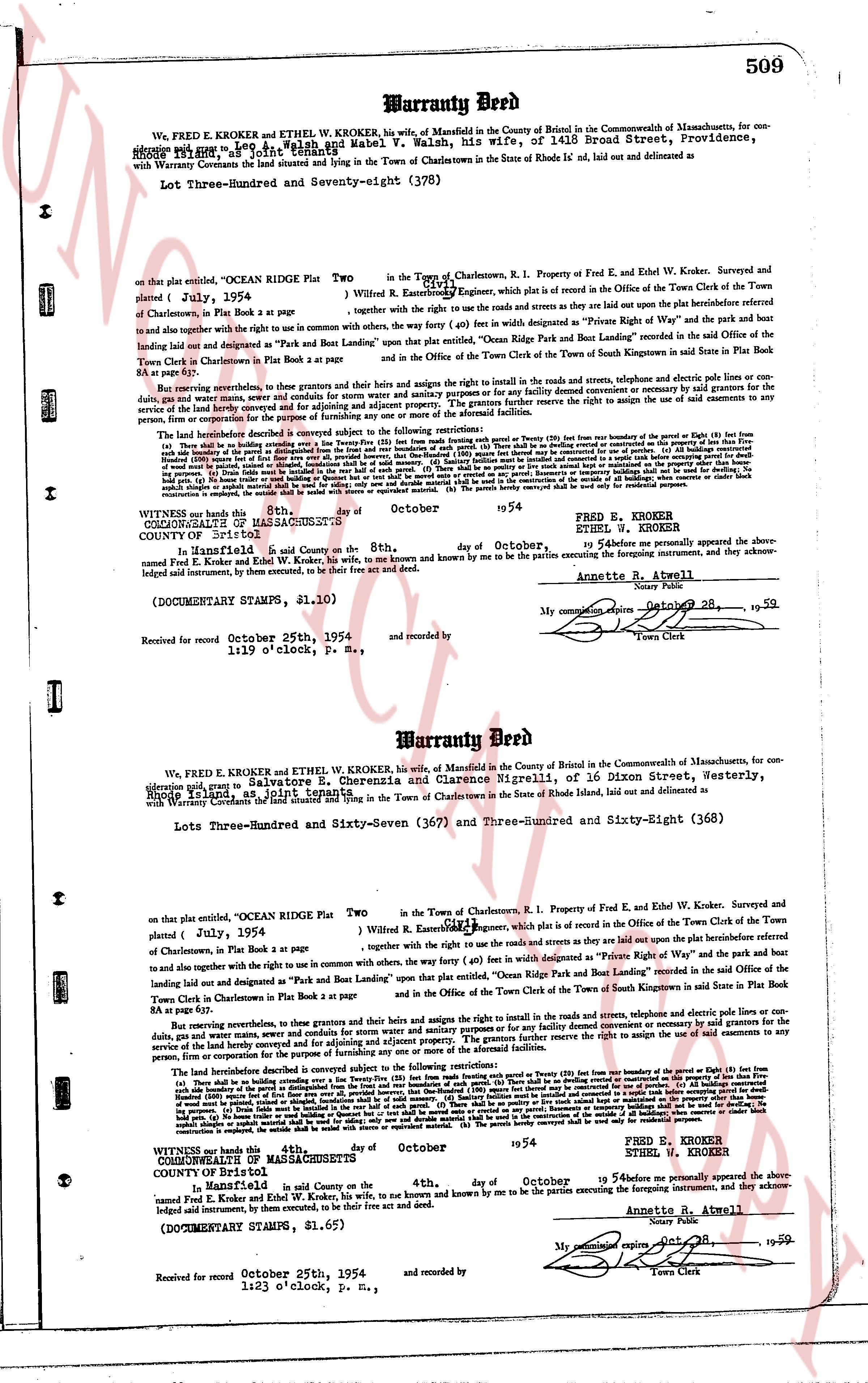
We, FRED E. KROKER and ETHEL W. KROKER, his wife, of Mansfield in the County of Benzin in the Commonwealth of Massachusetts, for consideration
of one dollar and other valuable consideration paid by Lee C. Walsh and Mabel V. Walsh, his wife, of 1415 Broad Street, Providence,
Rhode Island, in hand paid, grant, bargain and sell
with Warranty Covenants the land situated lying and situated in the Town of Charlestown in the State of Rhode Is' land, aid duly outlined and delineated as
Lot Three-Hundred and Seventy-eight (378)
on that plat entitled, "OCEAN RIDGE Plat Two" in the Town of Charlestown, R.I. Property of Fred E. and Ethel W. Kroker, Surveyed and
platted ( July, 1954 ) by William R. Eames, Engineer, which is plot is recorded in the Office of the Town Clerk of the Town
of Charlestown, in Plat Book 2 at page 34 ;
together with the right to use the roads and streets as they are laid out upon the plat and the bunhole prefabricated refered
to and together with the right to use the commons with other ways, the forty (40) feet in width designated as "Private Right of Way" and the park and boat
landing laid out and designated as "Park and Boat Landing West" located in the said Office of the Town Clerk of the Town
Town Clerk in Charlestown in Plat Book 2 at page 34
and in the Office of the Town Clerk of the Town of South Kingstown in said Plat Book 2 at page 34.
But reserving covenants, that in these grants and bargains the right to use the roads and streets, telephone and electric poles lines or con-
duits, gas and water pipes and other utilities shall be reserved to the grantors and their successors and assigns for the purpose of maintaining or service
of the said land hereby conveyed and for adjoining and adjacent property. The grantors further reserve the right to assign the use of said easements to any
person, firm or corporation for the purpose.
The land herein described is subject to the following covenants subject to the following restrictions:
(a) There shall be no building on the land except a dwelling house for the use of the owner or his family on a lot of not less than Twenty (20) feet from the boundary of the benutzt or East (East) line from
(b) The distance from the porch or any projection from the dwelling from the front and rear boundaries of such lot shall be Twenty (20) feet. (c) All buildings constructed
upon the land shall be set back from the side boundaries of the lot a distance of not less than Ten (10) feet. (d) No building or structure shall be used for commercial use. (e) All buildings constructed
upon the land shall be for residential purposes only. (f) No building shall be erected on the land which shall be more than two stories in height. (g) No building shall be erected on the land which shall be
of a temporary nature. (h) No building shall be erected on the land which shall be a trailer, mobile home or similar structure. (i) No building shall be erected on the land which shall be a garage,
out building, or accessory building, unless it be built in the rear half of such lot. (j) There shall be no planting of any tree, shrub, flower or other vegetation which shall be more than two stories in height. (k) No
permanent structure, including but not limited to fences, walls, hedges, etc. shall be erected on the land which shall be a garage,
out building, or accessory building, unless it be built in the rear half of such lot. (l) There shall be no planting of any tree, shrub, flower or other vegetation which shall be more than two stories in height. (m) No
permanent structure, including but not limited to fences, walls, hedges, etc. shall be erected on the land which shall be a garage,
out building, or accessory building, unless it be built in the rear half of such lot. (n) There shall be no planting of any tree, shrub, flower or other vegetation which shall be more than two stories in height. (o) No
restriction as imposed, the entire lot shall be used as one dwelling site or separate mortgaged. (p) The parcels hereby conveyed shall be used only for residential purposes.
WITNESSED our hands this 4th day of October 1954
(SEAL)
FRED E. KROKER
ETHEL W. KROKER
COUNTY OF Bristol
STATE OF Rhode Island, s.s. on the 4th day of October, 1954 before me personally appeared the above
named Fred E. Kroker and Ethel W. Kroker, his wife, to me known and by me known to be the parties executing the foregoing instrument, and they acknowledge
signed said instrument, by them executed, to be their free act and deed.
Annette R. Atwell
(DOCUMENTARY STAMPS, $1.10)
My commission expires October 28, 1959
Town Clerk
Received for record October 25th, 1954 1:19 o'clock, P. M., and recorded by
----
Warranty Deed
We, FRED E. KROKER and ETHEL W. KROKER, his wife, of Mansfield in the County of Benzin in the Commonwealth of Massachusetts, for con-
sideration paid, grant, bargain and sell to Salvatore E. Cherenzia and Clarence Nigrelli, of 16 Dixon Street, Westerly,
Rhode Island, in hand paid,
with Warranty Covenants the land situated lying and situated in the Town of Charlestown in the State of Rhode Island, aid duly outlined and delineated as
Lots Three-Hundred and Sixty-Seven (367) and Three-Hundred and Sixty-Eight (368)
on that plat entitled, "OCEAN RIDGE Plat Two" in the Town of Charlestown, R.I. Property of Fred E. and Ethel W. Kroker, Surveyed and
platted ( July, 1954 ) by William R. Eames, Engineer, which is plot is recorded in the Office of the Town Clerk of the Town
of Charlestown, in Plat Book 2 at page 34 ;
together with the right to use the roads and streets as they are laid out upon the plat and the bunhole prefabricated refered
to and together with the right to use the commons with other ways, the forty (40) feet in width designated as "Private Right of Way" and the park and boat
landing laid out and designated as "Park and Boat Landing East" located in the said Office of the Town Clerk of the Town
Town Clerk in Charlestown in Plat Book 2 at page 34
and in the Office of the Town Clerk of the Town of South Kingstown in said Plat Book 2 at page 34.
But reserving covenants, that in these grants and bargains the right to use the roads and streets, telephone and electric poles lines or con-
duits, gas and water pipes and other utilities shall be reserved to the grantors and their successors and assigns for the purpose of maintaining or service
of the said land hereby conveyed and for adjoining and adjacent property. The grantors further reserve the right to assign the use of said easements to any
person, firm or corporation for the purpose.
The land herein described is subject to the following covenants subject to the following restrictions:
(a) There shall be no building on the land except a dwelling house for the use of the owner or his family on a lot of not less than Twenty (20) feet from the boundary of the benutzt or East (East) line from
(b) The distance from the porch or any projection from the dwelling from the front and rear boundaries of such lot shall be Twenty (20) feet. (c) All buildings constructed
upon the land shall be set back from the side boundaries of the lot a distance of not less than Ten (10) feet. (d) No building or structure shall be used for commercial use. (e) All buildings constructed
upon the land shall be for residential purposes only. (f) No building shall be erected on the land which shall be more than two stories in height. (g) No building shall be erected on the land which shall be
of a temporary nature. (h) No building shall be erected on the land which shall be a trailer, mobile home or similar structure. (i) No building shall be erected on the land which shall be a garage,
out building, or accessory building, unless it be built in the rear half of such lot. (j) There shall be no planting of any tree, shrub, flower or other vegetation which shall be more than two stories in height. (k) No
permanent structure, including but not limited to fences, walls, hedges, etc. shall be erected on the land which shall be a garage,
out building, or accessory building, unless it be built in the rear half of such lot. (l) There shall be no planting of any tree, shrub, flower or other vegetation which shall be more than two stories in height. (m) No
permanent structure, including but not limited to fences, walls, hedges, etc. shall be erected on the land which shall be a garage,
out building, or accessory building, unless it be built in the rear half of such lot. (n) There shall be no planting of any tree, shrub, flower or other vegetation which shall be more than two stories in height. (o) No
restriction as imposed, the entire lot shall be used as one dwelling site or separate mortgaged. (p) The parcels hereby conveyed shall be used only for residential purposes.
WITNESSED our hands this 4th day of October 1954
(SEAL)
FRED E. KROKER
ETHEL W. KROKER
COUNTY OF Bristol
STATE OF Rhode Island, s.s. on the 4th day of October, 1954 before me personally appeared the above
named Fred E. Kroker and Ethel W. Kroker, his wife, to me known and by me known to be the parties executing the foregoing instrument, and they acknowledge
signed said instrument, by them executed, to be their free act and deed.
Annette R. Atwell
(DOCUMENTARY STAMPS, $1.62)
My commission expires October 28, 1959
Town Clerk
Received for record October 25th, 1954 1:23 o'clock, P. M., and recorded by
The page as recorded