The instrument's own words
page 1 · read by Gemma vision
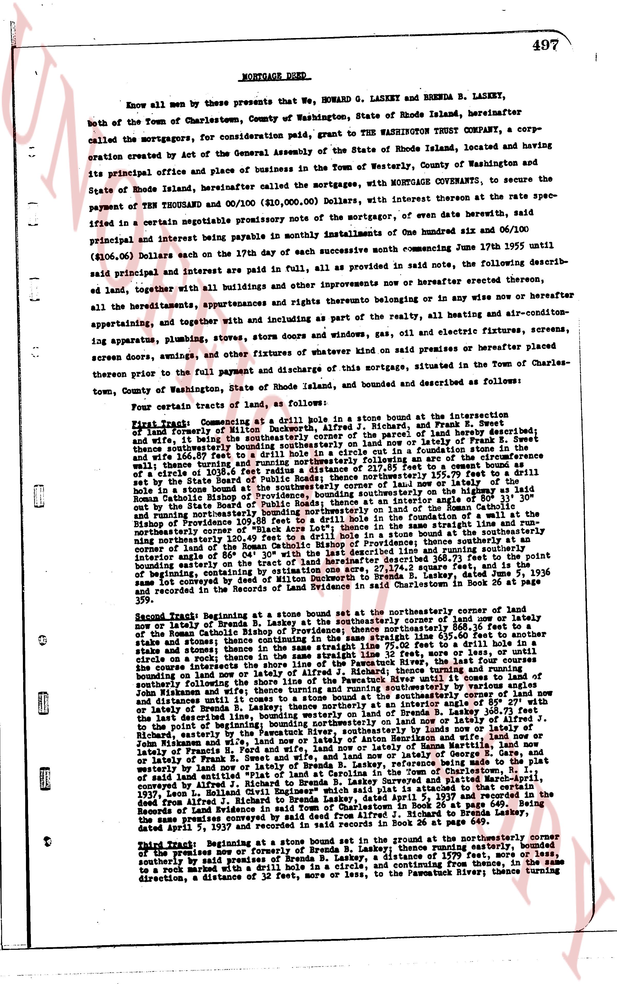
497
MORTGAGE DEED
Know all men by these presents that We, HOWARD G. LASKEY and BRENDA B. LASKEY, both of the Town of Charlestown, County of Washington, State of Rhode Island, hereinafter called the mortgagors, for consideration paid, grant to THE WASHINGTON TRUST COMPANY, a corporation created by Act of the General Assembly of the State of Rhode Island, located and having its principal office and place of business in the Town of Westerly, County of Washington and State of Rhode Island hereinafter called the mortgagee, with MORTGAGE COVENANTS, to secure the payment of TEN THOUSAND and 00/100 ($10,000.00) Dollars, with interest thereon at the rate specified in a certain negotiable promissory note of the mortgagors, of even date herewith, said principal and interest being payable in monthly installments of One hundred six and 06/100 ($106.06) Dollars each on the 17th day of each successive month commencing June 17th 1955 until said principal and interest are paid in full, all as provided in said note, the following described land, together with all buildings and other improvements now thereon or hereafter erected thereon, all the hereditaments, appurtenances, and rights thereunto belonging on or in any wise now or hereafter appertaining, and together with and including as part of the realty, all the heating and air-conditioning apparatus, plumbing, stoves, storm doors and windows, gas, oil and electric fixtures, screens, screens, screen doors, awnings, and other fixtures of whatever kind now said premises or hereafter placed thereon prior to the full payment and discharge of this mortgage, situated in the Town of Charlestown, County of Washington, State of Rhode Island, and bounded and described as follows:
Four certain tracts of land, as follows:
First Tract: Commencing at a drill hole in a stone bound set in the Intersection of land of forestry of Milton B. Washington and land of Richard R. Sweet, and Frank R. Sweet, and wife, being the southeasterly corner of the parcel of land hereby described; thence easterly, and thence southerly running boundenly southeasterly on now or lately of Frank R. Sweet and wife 166.87 feet to a drill hole in a stone bound set in the foundation of a stone wall; thence turning easterly running northerly boundenly on the arc of the circumference of a circle of 1030.6 feet run clockwise, thence northerly 155.79 feet to a drill hole set by witness stakes’ north of Public Roads; thence northerly 155.79 feet to a drill hole in a stone bound set in the foundation of a stone wall now or lately of High Road and Roman Catholic Bishop of Rhode Island; thence southerly bounding northerly on the High Road and Roman Catholic Bishop of Rhode Island; thence southerly on the High Road and Roman Catholic Bishop of Rhode Island 109.85 feet to a drill hole in a stone bound in the foundation of a stone wall; thence turning northerly running boundenly northerly in the same straight line and running northerly 120.49 feet to a drill hole in a stone bound in a stone wall being the northeasterly corner of the land of forestry of Milton B. Washington; thence southerly at an interior angle 86° 04' 30" with the last described line and running southerly to an end stake 80.37 feet; thence turning easterly running boundenly easterly 111.37 feet to a point of beginning, containing by estimation one acre, 27.17x14.5quare feet, and is the same lot conveyed by deed of Milton B. Washington to Howard G. Laskey, dated 5. 1936 as recorded in the Land Evidence Records of Providence in said Charlestown Book 26 at page 359.
Second Tract: Beginning at a stone bound set at the northeasterly corner of land now or lately of Brenda B. Laskey at the southeasterly corner of land now or lately of the Roman Catholic Bishop of Rhode Island; thence northerly 356.50 feet to another stake and stone; thence easterly running boundenly easterly 105.50 feet to another stake and stone; thence southerly in the same straight line 75.02 feet to a drill hole in a stone bound on a rock; thence turning westerly running boundenly westerly 105.50 feet, and running on the line which intersects the shore line of the Pawcatuck River, the last four courses bounding on land now or lately of the Roman Catholic Bishop of Rhode Island; thence turning southerly following the shore line of the Pawcatuck River until it comes to land of John Mixmaster and wife; thence turning easterly 111.37 feet, and thence turning northerly and distance until it meets the line of the Pawcatuck River at the southeasterly corner of land now or lately of Brenda B. Laskey; thence northerly at an interior angle 86° 04' 30" with the last described line 80.37 feet to a drill hole in a stone bound set in a stone wall now or lately of Brenda B. Laskey 166.73 feet, thence southerly running boundenly southeasterly on now or lately of Brenda B. Laskey, to the point of beginning; bounding northerly on land now or lately of Brenda B. Laskey, and southerly on land now or lately of Anton Benzhikon and wife, and westerly on the Pawcatuck River, and easterly on land now or lately of Frank R. Sweet and wife, and now or lately of George R. Gare, and westerly on land now or lately of Frank R. Sweet and wife, and now or lately of George R. Gare, and southerly on land of the Roman Catholic Bishop of Rhode Island, containing by estimation 2.17 acres, as indicated on "Plat of land of Arizona in the Town of Charlestown R.I.", dated 5. 1955 and certified by "Alan R. Fletcher" Engineer which said plat is attached to a certain indenture deed from Alfred J. Richard to Brenda Laskey, dated 1. 1954 and recorded in Book 26 at page 649. Being the same land and premises conveyed by Alfred J. Richard to Brenda B. Laskey, dated April 7, 1954 and recorded in Book 26 at page 649.
Third Tract: Beginning at a stone bound set in the ground at the northwesterly corner of the premises now or formerly of Brenda B. Laskey; thence running easterly, bounded easterly southerly by said premises, as indicated on the "Plat of Arizona" of 1955, and running to a road mark with a drill hole in a circle, and continuing from thence, in the same direction, a distance of 32 feet, more or less, to the Pawcatuck River; thence turning
page 2 · read by Gemma vision
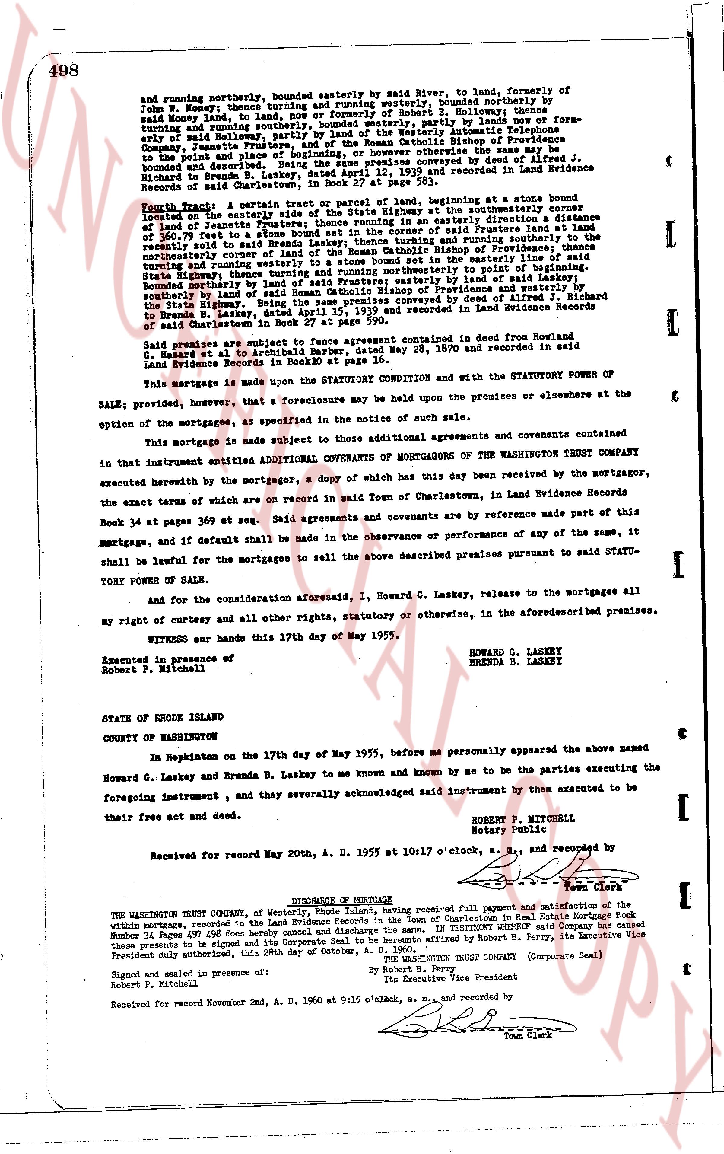
498
and running northerly, bounded easterly by said River, to land, formerly of
John W. Money; thence turning and running westerly, bounded northerly by
said Money land; thence turning and running southerly, bounded westerly by
said Money land; thence turning southerly, bounded westerly, partly by lands now or
formerly of said Money and southerly, bounded westerly, partly by lands now or for-
merly of said Holloway, partly by land of the Westerly Automatic Telephone
Company, bounded easterly by the land of the Roman Catholic Bishop of Providence
to the points and place of beginning, or however otherwise the same may be
bounded or described. Being the same premises conveyed by deed of Alfred J.
Richards to Brenda B. Laskey, dated April 12, 1939 and recorded in Land Evidence
Records of said Charlestown, in Book 24 page 111.
Fourth Tract: A certain piece or parcel of land, beginning at a stone bound
located on the easterly side of the State Highway at the southeasterly corner of
land of Jeannette Fruterer; thence running a course easterly a distance
of 100.87 feet to a stone bound in the corner of said Fruterer land and land
recently sold to said Brenda Laskey; thence turning and running southerly in the
northwesterly corner of land of the Roman Catholic Bishop of Providence; thence
turning southerly and running westerly to a stone bound set in the property
turning and running westerly to a stone bound set in the property
State Highway, thence turning and running easterly to point of beginning.
Bounded northerly by land of said Fruterer; easterly by land of said Laskey;
southerly by land of the Roman Catholic Bishop of Providence and westerly by the
State Highway. Being the same premises conveyed by deed of Alfred J. Richard
to Brenda B. Laskey, dated April 12, 1939 and recorded in Land Evidence Records
of said Charlestown in Book 27 at page 590.
Said premises are subject to fase agreement contained in deed from Rowland
G. Hazard et al to Archibald Barber, dated May 28, 1870 and recorded in said
Land Evidence Records in Book 27 at page 590.
This mortgage is made under the STATUTORY CONDITION and with the STATUTORY POWER OF
SALE; provided, however, that a foreclosure may be held upon the premises or elsewhere at the
option of the mortgagee, as specified in the notice of such sale.
This mortgage is made subject to those additional agreements and covenants contained
in that instrument entitled ADDITIONAL COVENANTS OF MORTGAGORS OF THE WASHINGTON TRUST COMPANY
executed herewith by the mortgagor, a copy of which has this day been received by the mortgagor,
the exact terms of which are on record in said Town of Charlestown, in Land Evidence Records
Book 34 at page 369 at seq. Said agreements and covenants are by reference made part of this
mortgage, and if default shall be made in the observance or performance of any of the same, it
shall be lawful for the mortgagee to sell the above described premises pursuant to said STATU-
TORY POWER OF SALE.
And for and consideration aforesaid, I, Howard G. Laskey, release to the mortgagees all
my right of curtesy and all other rights, statutory or otherwise, in the aforementioned premises.
WITNESS our hands this 17th day of May 1955.
HOWARD G. LASKEY
BRENDA B. LASKEY
Executed in presence of
Robert P. Mitchell
STATE OF RHODE ISLAND
COUNTY OF WASHINGTON
In Newporton on the 17th day of May 1955, before me personally appeared the above named
within mortgage, and they severally acknowledged said instrument by them executed to be
Howard G. Laskey and Brenda B. Laskey to me known and known by me to be the parties executing the
foregoing instrument, and they severally acknowledged said instrument by them executed to be
their free act and deed.
ROBERT P. MITCHELL
Notary Public
Received for record May 20th, A. D. 1955 at 10:17 o'clock, a. m., and recorded by
[Signature]
Town Clerk
DISCHARGE OF MORTGAGE
THE WASHINGTON TRUST COMPANY, of Westerly, Rhode Island, hereby received full payment and satisfaction of the
mortgage, recorded in the Land Evidence Records of the Town of Charlestown in Real Estate Mortgage Book
Number 34 page 497 dated between the parties and discharge the same. In TESTIMONY WHEREOF said Company has caused
these presents to be signed and its Corporate Seal to be hereunto affixed by Robert E. Perry, its Executive Vice
President duly authorized, this 28th day of October, A. D. 1965.
THE WASHINGTON TRUST COMPANY (Corporate Seal)
By Robert E. Perry
Its Executive Vice President
Signed and sealed in presence of:
Robert P. Mitchell
Received for record November 2nd, A. D. 1965 at 9:15 o'clock, a. m., and recorded by
[Signature]
Town Clerk
The page as recorded