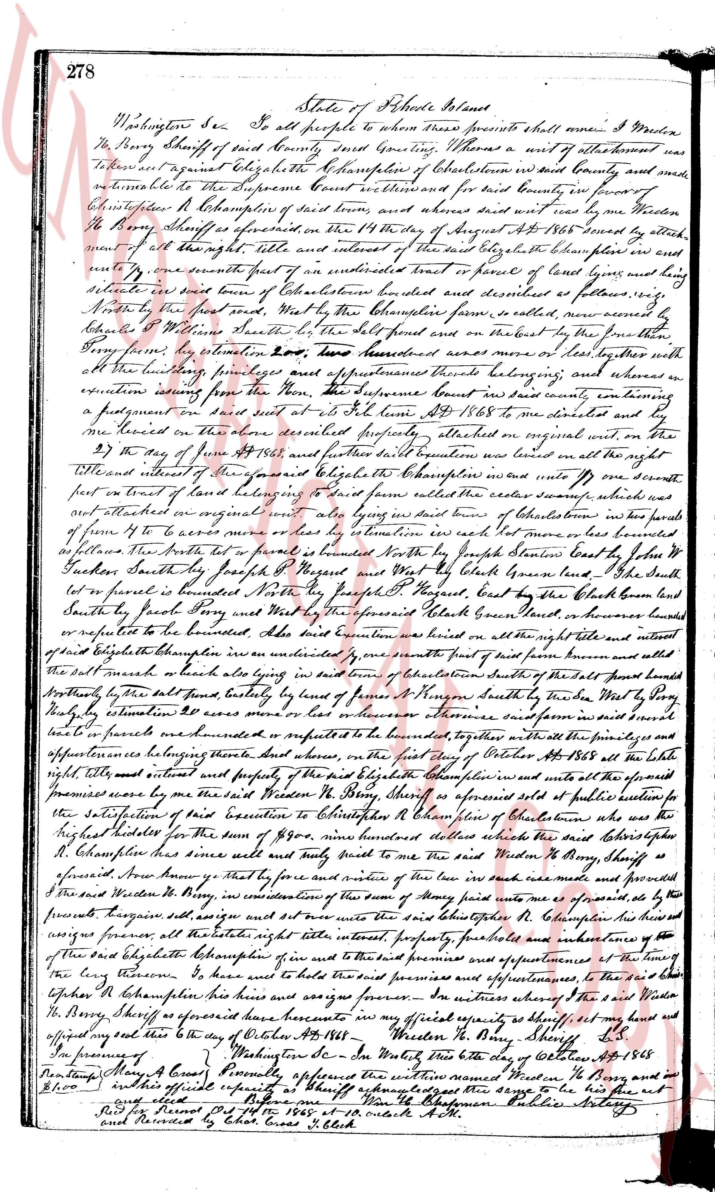
The instrument's own words
page 1
278
State of Rhode Island
Washington County SS To all people to whom these presents shall come I Warden
H. Berry Sheriff of said County Greeting, Whereas a writ of attachment was
to have been against Elizabeth Champelien of Charlestown in said County and said
writ was returnable to the Supreme Court seated westbound for said County in favor of
Christopher H. Champelien of said town and whereas said writ was read by me
H. Berry Sheriff as aforesaid, on the 14th day of August AD 1868 said debtor Champelien was and
remains all the right, title and interest of the said debtor Champelien for and over
only one seventh part of an undivided lot or parcel of land lying and being
situate in said town of Charlestown but described and described as follows viz
North by the first south east Way but by the Champelien farm is settled more narrow by
follows by Williams State line South east by the road and by the track on the farm to the
Berry farm viz estimation two hundred two hundred acres more or less together with
all the buildings privileges and appurtenances thereunto belonging and whereas the
execution issuing from the Supreme Court based in said county entertaining
a judgment on said suit entered on 14th June AD 1868 to me directed and by
me seized on the above described property attached on original writ on the
2nd day of June AD 1868 and further seized on an undivided one half the right
title and interest of an undivided one seventh part of one hundred one seventh
part or one seventh part of land lying and being situated in said county called the eastern swamp which
was attached on original writ on the 2nd day of June AD 1868 consisting of two parcels of
forms of ten to x acres more or less by estimation each lot more or less bounded
as follows the first lot is bounded North by Joseph state line bounded East by John P
Jackson South by Joseph Shepard Regard and West by the Black brook land the
second lot is bounded North by Joseph H. Regard East by the Black brook land
South by Joseph Berry and West by the aforesaid Black brook land whereas
said parcels of land were estimated at 200 dollars or however others whereas said farm was seized
and parcels were estimated at 200 acres more or less bounded to the border whereas together with
all the buildings privileges and appurtenances thereunto belonging parte the 1st day of October AD 1868 at the late
right title and interest and property of the said Elizabeth Champelien was and unto the aforesaid
premises caused by me the said Warden H. Berry Sheriff as aforesaid sold at public auction for
the satisfaction of a debt executed to Christopher H. Champelien of Charlestown who as the
highest bidder offered the sum of 890 eight hundred dollars which the said Elizabeth
H. Champelien has since sold and duly paid to me the said Warden H. Berry Sheriff as
aforesaid from hence it may be for cause and notice of the same such sale was made and proceeded
I the said Warden H. Berry Sheriff in my capacity as Sheriff of the county of said premises as aforesaid
the process however sold and set over unto the said Christopher H. Champelien his heirs and
assigns forever all the estate right title interest property privileges and appurtenances of the
said Elizabeth Champelien of and unto the said premises and appurtenances of the
long farm whereas I have sold the said premises and appurtenances to the said
Christopher H. Champelien his heirs and assigns forever In witness whereof I the said Warden
H. Berry Sheriff as aforesaid have hereunto in my official capacity as Sheriff set my hand and
affixed my seal this 10th day of October AD 1868
In presence of Warden H. Berry Sheriff, SS
Dontam [illegible] My Case Personally appeared this day on October 10th AD 1868
before me in this official capacity as Sheriff acknowledged the same to be his free act
and deed
Signed and sealed before me Wm H. Champelien Public Notary
page 2
478
center line of said Post Road at station 369 plus 40 as shown on
Rhode Island Department Plat No. 662, Sheet 74.1, thence running
westerly by the old road and parallel to the center line of the Post Road a distance
of thirty-three and forty-five hundredths (33.45) feet to aforesaid
highway bound; thence turning an angle of south 46 deg 34 min and
highway bound westerly by a line perpendicular to said highway line a distance of one
hundred fifty-two and fourteen hundredths (152.14) feet northerly from station
369 plus 85; thence turning an interior angle of 117 deg 02 min and
35 minutes and turning easterly an interior angle of 117 deg 02 min and
35 minutes and turning easterly an interior angle of 90 degrees and
one hundred two and fifty-nine hundredths (102.59) highway line a dis-
tance of one hundred fifty-two and eighty-eight hundredths (152.88) feet
to an iron pipe; thence turning an interior angle of 90 degrees and
10 minutes and running northerly a distance of one hundred eight
seventy-seven and ten hundredths (187.10) feet to an iron pipe;
thence turning an interior angle of 140 degrees and 24 minutes and size
easterly a distance of one hundred sixty-eight and seventy-four
hundredths (168.74) feet to a drill hole in a boulder; thence turning
an interior angle of 78 degrees 05 minutes and running southerly
a distance of one hundred twenty-six and eighty-four hundredths
(126.84) feet to a drill hole in a boulder; thence turning an
interior angle of 93 degrees and fifty-nine hundredths (93.59) feet
to a drill hole in a boulder; thence turning an interior angle of some
forty-nine and eighty hundredths (149.80) feet to a drill hole in a
boulder; thence turning an interior angle of 92 degrees and 12 minutes
and running southerly a distance of one hundred ten and seven
hundredths (110.07) feet to a drill hole in a boulder; thence turning
an interior angle of 169 degrees and 43 minutes and running southeasterly
a distance of one hundred ten and four-tenths (110.40) feet
to a drill hole and place of beginning, this last course making an
interior angle of 93 degrees and 01 minutes with the first described
course.
This tract contains an area of 0.205 acres and is bounded on the south
by the Post Road, on the west, north and east by other land of the grantor.
Meaning and intent being to convey a portion of the premises conveyed to
the grantors by a deed from Sarah A. Case by deed dated November 12,
1926 and duly recorded in the Land Evidence Records of said Town of
Charlestown in Book 42 at page 318.
In consideration of the purchase price cited in a modification of this
sale and purchase the grantors agree to build and make passable
a road over the westernmost twenty feet of the premises hereby
conveyed, said road way or right of way is bounded as follows:
Beginning at an iron pipe driven in the northerly side of the highway at
the southwestern corner of the parcel here conveyed thence running
northerly one hundred seventy-seven and forty-eight hundredths (177.48)
feet to an iron pipe at an angle; thence turning an angle of 140
degrees and 35 minutes and running easterly one hundred sixty-eight
and forty-one hundredths (168.41) feet to a drill hole in a boulder;
thence running southeasterly a distance of forty (40) feet, more or less,
thence running southeasterly and southeasterly in a line parallel with a first
line running further to the highway aforesaid
said thence running westerly to the point and place of beginning.
The purchasers agree to make passable a right of way or drive over the
above described premises with a width of not less than sixteen (16)
feet in width within three years of the date of this deed, all work to be
done at the expense of the grantors, the grantors reserve to themselves,
their heirs and assigns in perpetuity, the said right of way at all times and
for all purposes until a highway, and the heirs and assigns a right of way as
now exists from the highway over other lands of the grantors and since this
reservation is located about forty (40) feet westerly of the dwelling, it is
to remain in full force and effect until such time as the right of way
(40) feet in width hereby reserved shall have been built and made passable
for a means of access to other property of the grantors, at which time this
reservation of the right of way of forty (40) feet westerly from
the dwelling shall cease to be null and void.
WITNESS our hands this 9th day of May, 1955.
FRITZ J. SWANSON
ERNESTINE B. SWANSON
(DOCUMENTARY STAMPS, $9.80)
STATE OF RHODE ISLAND
COUNTY OF WASHINGTON
In Westerly on the 9th day of May 1955, before me personally appeared FRITZ J.
SWANSON and ERNESTINE E. SWANSON, husband and wife, to me known and by me to
be the parties executing the foregoing instrument, and they acknowledged said instrument by
them executed to be their free act and deed.
HOWARD E. THORP (Notarial Seal)
Notary Public.
Received for record May 10th, A. D. 1955 at 4:15 o'clock, p. m., and recorded by
Town Clerk
The page as recorded