The instrument's own words
page 1 · read by Gemma vision
435
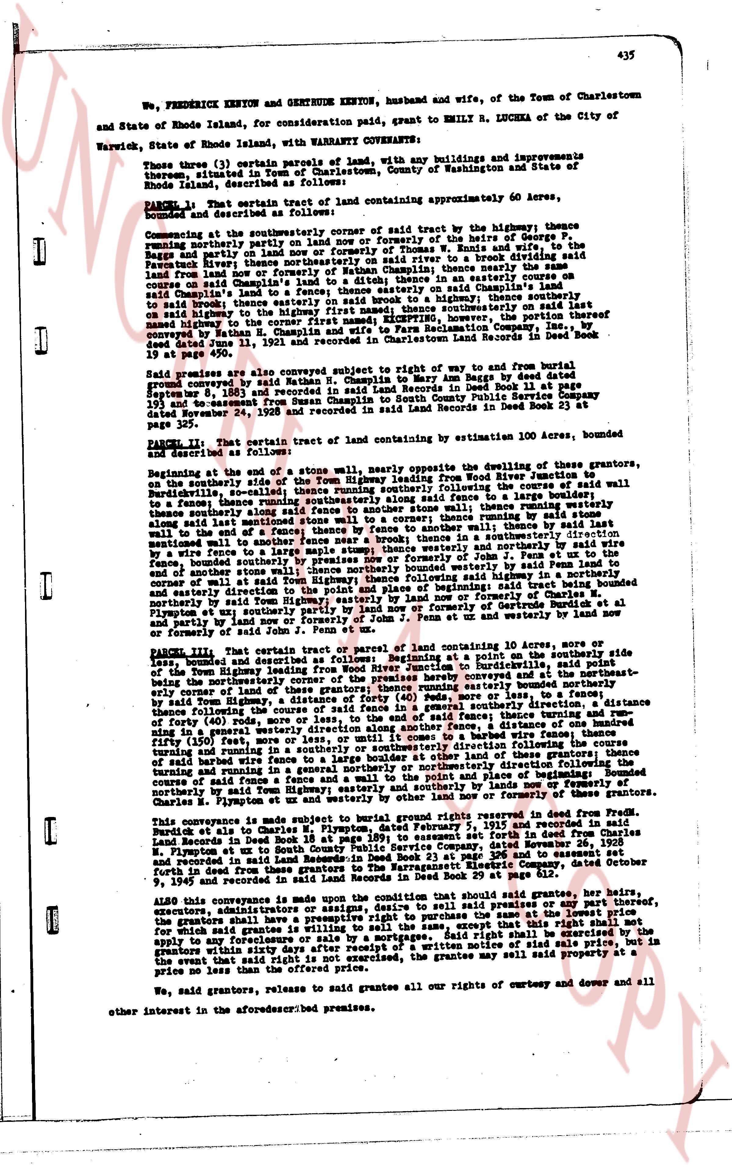
We, FREDERICK KENYON and GERTRUDE KENYON, husband and wife, of the Town of Charlestown
and State of Rhode Island, for consideration paid, grant to EMILY R. LUCHKA of the City of
Warwick, State of Rhode Island, with WARRANTY COVENANTS:
Those three (3) certain parcels of land, with any buildings and improvements
thereon, situated in the Town of Charlestown, County of Washington and State of
Rhode Island, described as follows:
PARCEL 1: That certain tract of land containing approximately 60 Acres,
bounded and described as follows:
Commencing at the southeasterly corner of said tract by the highway; thence
running northerly past Norway's land and now or formerly of the heirs of George F.
Bagley and now or formerly of Thomas W. Ennis and wife the south line of
Fawnick Park now; thence northerly since then to a brook dividing said land
from Norway's land now or formerly of Nathan H. Champlain; thence namely she are
course on said Champlain's land to said brook; thence on a southerly course on
said Champlain's land to said brook; thence easterly on said Champlain's land
to said brook; thence easterly on said brook to a highway; thence southerly on
said highway to the corner first named; EXCEPTING, however, the portion thereof
conveyed dated June 11, 1921 and recorded in Land Records then Book Deed 19
at page 450.
Said premises are also conveyed subject to right of way and to return and bound
protocol conveyed by said Nathan H. Champlain to Mary Ann Baggs by deed dated
September 8, 1863 and recorded in Land Records in Deed Book 13 at page 193
and the easement for Right of Way from South County Public Service Company
dated November 24, 1928 and recorded in said Land Records in Deed Book 23 at
page 175.
PARCEL 2: That certain tract of land containing by estimation 100 Acres, bounded
and described as follows:
Beginning at the end of a stone wall, namely southeast vicinity of the dwelling of the grantors,
on the northerly side of the Town Highway leading from Wood River Junction to
Burdickville, said stone wall being the north line of said tract; thence running westerly to
said fence a boundary thence running southeasterly following said stone wall
to a fence; thence southerly along said fence to another stone wall; thence running westerly
to said end of a fence; thence by fence to another stone wall; thence running westerly
along said wall to the end of a fence; thence running westerly by running by
mentionned to another fence wall a fence; thence running westerly by
a wire fence to the end of a fence; thence running westerly and northerly by wire
fence, bounded southerly by premises now or formerly of John F. Penn; thence
and of some distance running northerly by wire fence, bounded westerly by said Penn land to
and of some distance running northerly by wire fence, bounded westerly by said
corner of wall at said Town Highway; thence following said highway to the
southeasterly corner of said tract; thence running easterly following said tract being bounded
northerly by said Town Highway, easterly by land now or formerly of George F.
Bagley and now or formerly of the heirs of George Burdick et al
and partly by land now or formerly of John F. Penn ut and westerly by land now
or formerly of said John F. Penn ut and westerly by land now
PARCEL 3: That certain tract or parcel of land containing 10 Acres, more or
less, bounded and described as follows: Beginning at a point on the southerly side
of the Town Highway leading from Wood River Junction to Burdickville, more or
less than the northwesterly corner of the premises hereby conveyed and at the northeast-
erly corner of land of the grantors; thence running easterly to a fence; thence
following said fence the course of said fence in a general easterly direction a distance
of 40 rods; more or less, to a fence; thence running southerly by said fence a distance
of 40 rods; more or less, to said fence; thence turning and running
in a general westerly direction along another fence, a distance
of 40 rods; more or less, to said fence; thence running northerly by said wire fence; thence
turning and running in a southerly or southeasterly direction following said
wire fence to the end of a fence; thence running northerly by said fence; thence
turning and running in a general northerly or northeasterly direction following the
course of said fence to the point of beginning; said tract being bounded
northerly by said Town Highway; easterly and southerly by lands now or formerly of
Charles H. Plumpton et ut and westerly by lands now or formerly of
Charles H. Plumpton.
This conveyance is made subject to bound by rental rights reserved in deed from
Fredrick Kenyon to Charles H. Plumpton dated February 5, 1905 and recorded in said
Land Records in Deed Book 18 at page 399, to said rental rights being in full force and
effect. Also subject to an easement for Right of Way, conveyed dated November 26, 1928
and recorded in said Land Records in Deed Book 23 at page 168 and to an easement
for Right of Way from South County Public Service Company, dated October
9, 1945 and recorded in said Land Records in Deed Book 29 at page 812.
ALSO this conveyance is made upon the condition that should said grantee, her heirs,
executors, administrators or assigns, offer to sell the premises or any part thereof,
the grantors shall have a preemptive right to purchase the same at the lowest price
for which said grantee is willing to sell. Said right shall be exercised by the
apply to refinance or refinance or by a mortgage. Said right shall be exercised by the
grantors within sixty days after receipt of a written notice of said offer, and in
the event that said right of purchase is not exercised, the grantee may sell said property at a
price no less than the offered price.
We, said grantors, release to said grantee all our rights of curtesy and dower and
all other interest in the aforesaid premises.
page 2 · read by Gemma vision
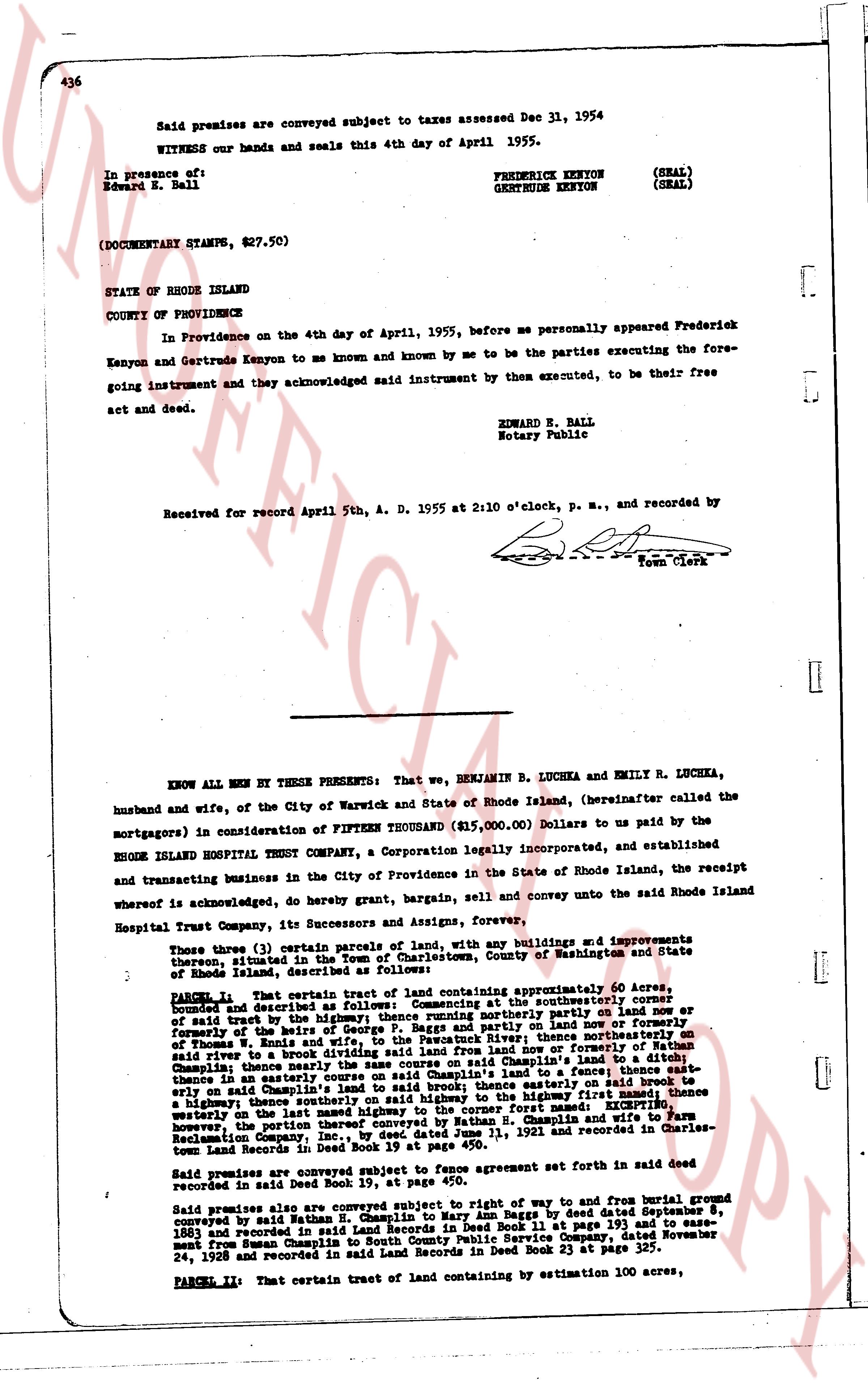
Said premises are conveyed subject to taxes assessed Dec 31, 1954
WITNESS our hands and seals this 4th day of April 1955.
In presence of:
Edward E. Ball
FREDERICK KENYON (SEAL)
GERTRUDE KENYON (SEAL)
(DOCUMENTARY STAMPS, $27.50)
STATE OF RHODE ISLAND
COUNTY OF PROVIDENCE
In Providence on the 4th day of April, 1955, before me personally appeared Frederick Kenyon and Gertrude Kenyon to me known and known by me to be the parties executing the foregoing instrument and they acknowledged said instrument by them executed, to be their free act and deed.
EDWARD E. BALL
Notary Public
Received for record April 5th, A. D. 1955 at 2:10 o'clock, P. M., and recorded by
[Signature]
Town Clerk
----
KNOW ALL MEN BY THESE PRESENTS: That we, BENJAMIN B. LUCHKA and EMILY R. LUCHKA, husband and wife, of the City of Warwick and State of Rhode Island, (hereinafter called the mortgagors) in consideration of FIFTEEN THOUSAND ($15,000.00) Dollars to us paid by the RHODE ISLAND HOSPITAL TRUST COMPANY, a Corporation legally incorporated, and established and transacting business in the City of Providence in the State of Rhode Island, the receipt whereof is acknowledged, do hereby grant, bargain, sell and convey unto the said Rhode Island Hospital Trust Company, its Successors and Assigns, forever,
Those (three) (3) certain parcels of land, with any buildings and improvements thereon, situated in the Town of Charlestown, County of Washington and State of Rhode Island, described as Follows:
PARCEL I: That certain tract of land containing approximately 60 Acres, bounded and described as follows: Beginning at the southeasterly corner of said tract by the highway; thence running northerly part of the line now or formerly the west line of the land of [?] and partly on the line now or formerly of Thomas N. Kunds and wife, to the Pawcatuck River; thence northerly on said river to a stone wall; thence easterly on said wall to the line now or formerly of Nathan Champlain; thence northerly thence south on said Champlain's land to a ditch; thence in a northeasterly direction to the highway and to a grant thence southeasterly on said Champlain's land to said brook; thence easterly on said brook to a highway; thence southeasterly thence to the highway; thence running southwesterly on the highway thence southeasterly to the corner first named: EXCEPTING however, the portion then conveyed westernly by Nathan H. Champlain and wife, 1921 and recorded in Charles-town Land Records in Deed Book 19 at page 450.
Said premises are conveyed subject to fence agreement set forth in said deed recorded in said Deed Book 19, at page 450.
Said premises are further subject to right of way and to right from burial ground conveyed by said Nathan H. Champlain to Harry Bugg by deed dated September 8, 1883 and recorded in said Charlestown Land Records Deed Book 12 at page 193; and to easement from Rhode Island South Public Service Company, Dated November 24, 1928 and recorded in said Land Records in Deed Book 23 at page 325.
PARCEL II: That certain tract of land containing by estimation 100 acres,
The page as recorded