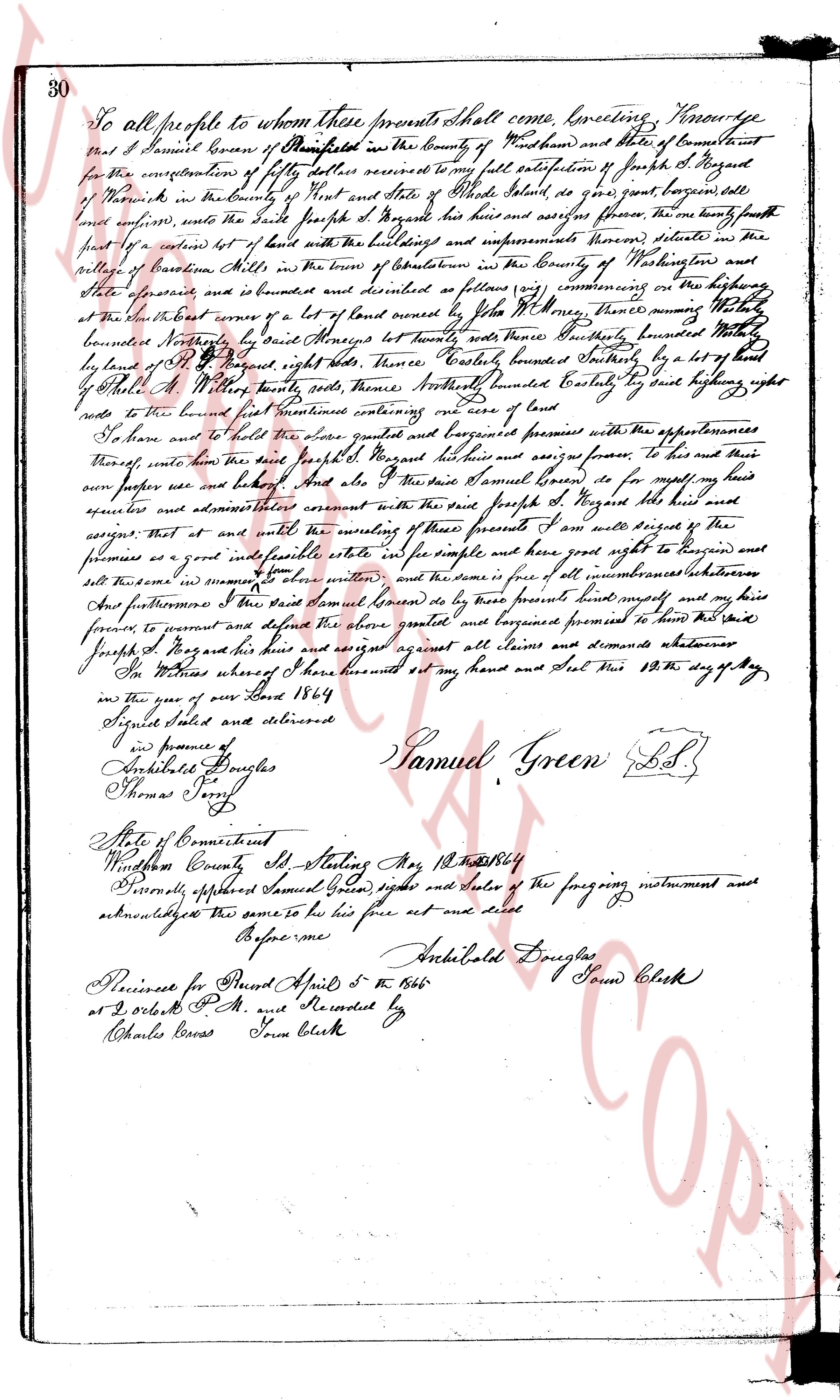
The instrument's own words
page 1
30
To all people to whom these presents shall come, Greetings. Know ye
that I Samuel Green of Pawtucket in the county of Providence and state of Connecticut
for the consideration of fifty dollars received to my full satisfaction of Joseph S. Hazard
of North Providence in the county of Providence and state of Rhode Island, do grant bargain sell
and convey, unto the said Joseph S. Hazard his heirs and assigns forever, the one hundredly fourth
part of a certain lot of land with the buildings and improvements thereon situated in the
part of providence Plantations in the county of Providence and state of Rhode Island
the aforesaid lot is bounded and described as follows namely commencing on the highway
at the north east corner of a lot of land owned by John Miller, then running south
bounded northly by said Samuel Green forty rods thence easterly bounded northly hundred
by land of Joseph S. Hazard right heirs forty rods, thence southerly bounded northly by a lot of land
by said A. Miller forty rods, southerly bounded northly Samuel Green forty rods highway north
rods to the bound line first mentioned containing one acre of land
To have and to hold the said grant bargained and premises with the appurtenances
thereof unto the said Joseph S. Hazard his heirs and assigns forever to his and their
uses and behoof and also I the said Samuel Green do for myself my heirs
assigns and administrators covenant with the said Joseph S. Hazard his heirs and
assigns that at and with the meaning of these presents I am and will remain the
promisor of a good and lawful title as the simple and have good right to bargain and
sell these premises in common to obtain written and the same is free of all incumbrances whatever
Save and furthermore I the said Samuel Green do by these presents remise release and my heirs
forever to present and defend the above granted and bargained premises to have their heirs
Joseph S. Hazard his heirs against all claims and demands whatever
In witness whereof I have hereunto set my hand and seal this 10th day of May
in the year of our Lord 1864
Signed sealed and delivered
in presence of
Archibald Douglas
Thomas Joy
State of Connecticut
Windsor County ssd. Attesting Me 12th May 1864
Personally appeared Samuel Green, signer and sealer of the foregoing instrument and
acknowledged the same to be his free act and deed
Before me
Archibald Douglas Second Clerk
Presented for Record April 5th 1866
at 2 O'clock P.M. and Recorded by
Charles Cross Town Clerk
page 2
238
The Grantee, her heirs and assigns, are hereby grantee all the benefits, rights
and privileges as set forth and contained in the aforesaid deeds, and this conveyance
is made and accepted subject to all of the conditions, reservations and restrictions con-
tained therein.
The consideration of this deed is such that no Internal Revenue Stamps are required.
We, Charles Reed and Sophia E. Reed, release to said Grantee all our right of
curtesy and dower, respectively, and all other interest in and to the aforesaid described
premises.
WITNESS our hands this 10th day of August, 1954.
CHARLES REED
SOPHIA E. REED
STATE OF RHODE ISLAND
COUNTY OF WASHINGTON
In Charlestown, on the 10th day of August, 1954, before me personally appeared
Charles Reed and Sophia E. Reed, husband and wife, both to me known and known by me to be
the parties executing the foregoing instrument, and they acknowledged said instrument, by
them executed, to be their free act and deed.
LINTON L. BROWN
Notary Public
Received for record August 10th, A. D. 1954 at 10:00 o'clock, a. m., and recorded
by [Signature] Town Clerk
Anita I. Henault, Formerly Anita I. Keyes, of the City of Central Falls, County of
Providence, State of Rhode Island, surviving joint tenant and daughter of Octavien E. Henault,
late of said City, County and State, deceased March 22, 1950, for consideration paid, grant
to Emile J. Stanek and Bertha C. Stanek, husband and wife, of the City of Pawtucket, in said
County and State, as joint tenants and not as tenants in common; with WARRANTY COVENANTS
(Description, and Incumbrances, if any)
Two certain lots of land, with all the buildings and improvements thereon, situated
in the town of Charlestown, County of Washington and State of Rhode Island, laid out and
designated as lots number seven hundred seven sixteen (716) and seven hundred seventeen (717) on
that plat entitled "Charlestown by the Sea, Owned and Developed by Thomas F. Reilly, Location
Charlestown, Rhode Island, Scale 1" = 100, dated July 25th, 1934, K. W. Leighton, Civil En-
gineer, New Haven, Conn." which said plat is on record in the Office of the Town Clerk of
said Charlestown.
Said lots together form one tract, bounded as follows:
Southerly : by Craig Street, as shown on said Plat, fifty (50) feet,
more or less;
Westerly : by lot number seven hundred eighteen (718) as shown on
said Plat, one hundred (100) feet, more or less;
Northerly : by lots number six hundred seventy-nine (679) and six
hundred eighty (680) as shown on said Plat, fifty (50)
feet, more or less, and
Easterly : by lot number seven hundred fifteen (715) as shown on
said Plat, one hundred (100) feet, more or less.
The page as recorded