The instrument's own words
page 1 · read by Gemma vision
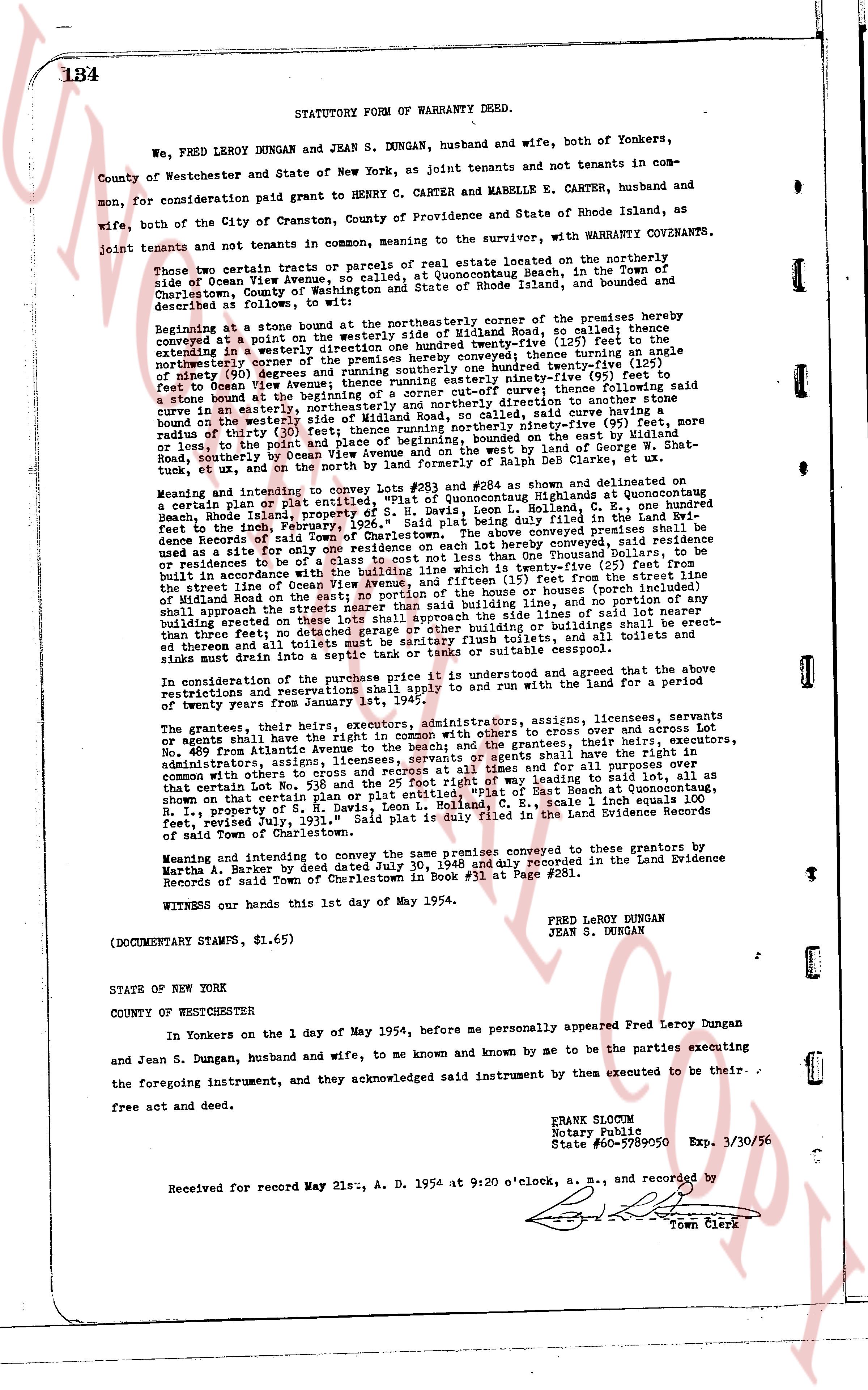
134 STATUTORY FORM OF WARRANTY DEED.
We, FRED LEROY DUNGAN and JEAN S. DUNGAN, husband and wife, both of Yonkers, County of Westchester and State of New York, as joint tenants and not tenants in common, for consideration paid grant to HENRY C. CARTER and MABELLE E. CARTER, husband and wife, both of the City of Cranston, County of Providence and State of Rhode Island, as joint tenants and not tenants in common, meaning to sever the tenancy, with WARRANTY CONVEYANCE.
Those two certain tracts or parcels of real estate located on the northeasterly side of Ocean View Avenue, so called at Quonochontaug Beach, in the Town of Charlestown, County of Washington and State of Rhode Island, bounded and described as follows:
Beginning at a stone bound at the northeasterly corner of the premises hereby conveyed at a point on the westerly line of the State of Rhode Island, now so called; thence extending in a westerly direction south forty-one degrees twenty-one minutes one hundred twenty-five (125) feet to the edge of the northeasterly corner of the premises hereby conveyed, thence turning an angle of sixty degrees east, running south forty-one degrees twenty-one minutes one hundred twenty-five (125) feet to the edge of Ocean View Avenue; thence running easterly ninety-nine feet's distance to a stone bound on the boundary line of the premises hereby conveyed of curve following said stone bound on the boundary line of the premises hereby conveyed of curve following said curve in an easterly, northeasterly and northeasterly direction to another stone bound on the boundary line of the premises hereby conveyed, said stone bound having a radius of thirty (30) feet; thence running northeasterly ninety-nine (99) feet; save and except, or to lose, to the point of beginning; bounded on the east by the land of George W. Shat- tuck, et ux, and on the north by the land formed by State Road, et al, and on the south by Ocean View Avenue and on the west by the land of George W. Shat- tuck, et ux, and on the north by the land formed by State Road, et al.
Meaning and intent to convey the same premises conveyed to #284 as shown and delineated on a certain plat of lines and distances of "Quonochontaug Beach at Quonochontaug, Rhode Island, property of S. E. Davis, Leon L. Rolland, C. E.," being duly filed in the Land Evidence books of the Town of Charlestown, Rhode Island, and being duly filed in the Land Evidence books of the Town of Charlestown. The above conveyed premises conveyed, said residence to be of a class to suit the land, and containing twenty-five (25) feet from the street line of Ocean View Avenue, and fifteen (15) feet from the westerly line of the land, and containing twenty-five (25) feet from the easterly line of the land, and containing twenty-five (25) feet from the southerly line of the land, and containing twenty-five (25) feet from the northerly line of the land, and containing twenty-five (25) feet from the southerly line of the land, and containing twenty-five (25) feet from the northerly line of the land, and containing twenty-five (25) feet from the southerly line of the land, and containing twenty-five (25) feet from the northerly line of the land, and containing twenty-five (25) feet from the southerly line of the land, and containing twenty-five (25) feet from the northerly line of the land, and containing twenty-five (25) feet from the southerly line of the land, and containing twenty-five (25) feet from the northerly line of the land, and containing twenty-five (25) feet from the southerly line of the land, and containing twenty-five (25) feet from the northerly line of the land, and containing twenty-five (25) feet from the southerly line of the land, and containing twenty-five (25) feet from the northerly line of the land, and containing twenty-five (25) feet from the southerly line of the land, and containing twenty-five (25) feet from the northerly line of the land, and containing twenty-five (25) feet from the southerly line of the land, and containing twenty-five (25) feet from the northerly line of the land, and containing twenty-five (25) feet from the southerly line of the land, and containing twenty-five (25) feet from the northerly line of the land, and containing twenty-five (25) feet from the southerly line of the land, and containing twenty-five (25) feet from the northerly line of the land, and containing twenty-five (25) feet from the southerly line of the land, and containing twenty-five (25) feet from the northerly line of the land, and containing twenty-five (25) feet from the southerly line of the land, and containing twenty-five (25) feet from the northerly line of the land, and containing twenty-five (25) feet from the southerly line of the land, and containing twenty-five (25) feet from the northerly line of the land, and containing twenty-five (25) feet from the southerly line of the land, and containing twenty-five (25) feet from the northerly line of the land, and containing twenty-five (25) feet from the southerly line of the land, and containing twenty-five (25) feet from the northerly line of the land, and containing twenty-five (25) feet from the southerly line of the land, and containing twenty-five (25) feet from the northerly line of the land, and containing twenty-five (25) feet from the southerly line of the land, and containing twenty-five (25) feet from the northerly line of the land, and containing twenty-five (25) feet from the southerly line of the land, and containing twenty-five (25) feet from the northerly line of the land, and containing twenty-five (25) feet from the southerly line of the land, and containing twenty-five (25) feet from the northerly line of the land, and containing twenty-five (25) feet from the southerly line of the land, and containing twenty-five (25) feet from the northerly line of the land, and containing twenty-five (25) feet from the southerly line of the land, and containing twenty-five (25) feet from the northerly line of the land, and containing twenty-five (25) feet from the southerly line of the land, and containing twenty-five (25) feet from the northerly line of the land, and containing twenty-five (25) feet from the southerly line of the land, and containing twenty-five (25) feet from the northerly line of the land, and containing twenty-five (25) feet from the southerly line of the land, and containing twenty-five (25) feet from the northerly line of the land, and containing twenty-five (25) feet from the southerly line of the land, and containing twenty-five (25) feet from the northerly line of the land, and containing twenty-five (25) feet from the southerly line of the land, and containing twenty-five (25) feet from the northerly line of the land, and containing twenty-five (25) feet from the southerly line of the land, and containing twenty-five (25) feet from the northerly line of the land, and containing twenty-five (25) feet from the southerly line of the land, and containing twenty-five (25) feet from the northerly line of the land, and containing twenty-five (25) feet from the southerly line of the land, and containing twenty-five (25) feet from the northerly line of the land, and containing twenty-five (25) feet from the southerly line of the land, and containing twenty-five (25) feet from the northerly line of the land, and containing twenty-five (25) feet from the southerly line of the land, and containing twenty-five (25) feet from the northerly line of the land, and containing twenty-five (25) feet from the southerly line of the land, and containing twenty-five (25) feet from the northerly line of the land, and containing twenty-five (25) feet from the southerly line of the land, and containing twenty-five (25) feet from the northerly line of the land, and containing twenty-five (25) feet from the southerly line of the land, and containing twenty-five (25) feet from the northerly line of the land, and containing twenty-five (25) feet from the southerly line of the land, and containing twenty-five (25) feet from the northerly line of the land, and containing twenty-five (25) feet from the southerly line of the land, and containing twenty-five (25) feet from the northerly line of the land, and containing twenty-five (25) feet from the southerly line of the land, and containing twenty-five (25) feet from the northerly line of the land, and containing twenty-five (25) feet from the southerly line of the land, and containing twenty-five (25) feet from the northerly line of the land, and containing twenty-five (25) feet from the southerly line of the land, and containing twenty-five (25) feet from the northerly line of the land, and containing twenty-five (25) feet from the southerly line of the land, and containing twenty-five (25) feet from the northerly line of the land, and containing twenty-five (25) feet from the southerly line of the land, and containing twenty-five (25) feet from the northerly line of the land, and containing twenty-five (25) feet from the southerly line of the land, and containing twenty-five (25) feet from the northerly line of the land, and containing twenty-five (25) feet from the southerly line of the land, and containing twenty-five (25) feet from the northerly line of the land, and containing twenty-five (25) feet from the southerly line of the land, and containing twenty-five (25) feet from the northerly line of the land, and containing twenty-five (25) feet from the southerly line of the land, and containing twenty-five (25) feet from the northerly line of the land, and containing twenty-five (25) feet from the southerly line of the land, and containing twenty-five (25) feet from the northerly line of the land, and containing twenty-five (25) feet from the southerly line of the land, and containing twenty-five (25) feet from the northerly line of the land, and containing twenty-five (25) feet from the southerly line of the land, and containing twenty-five (25) feet from the northerly line of the land, and containing twenty-five (25) feet from the southerly line of the land, and containing twenty-five (25) feet from the northerly line of the land, and containing twenty-five (25) feet from the southerly line of the land, and containing twenty-five (25) feet from the northerly line of the land, and containing twenty-five (25) feet from the southerly line of the land, and containing twenty-five (25) feet from the northerly line of the land, and containing twenty-five (25) feet from the southerly line of the land, and containing twenty-five (25) feet from the northerly line of the land, and containing twenty-five (25) feet from the southerly line of the land, and containing twenty-five (25) feet from the northerly line of the land, and containing twenty-five (25) feet from the southerly line of the land, and containing twenty-five (25) feet from the northerly line of the land, and containing twenty-five (25) feet from the southerly line of the land, and containing twenty-five (25) feet from the northerly line of the land, and containing twenty-five (25) feet from the southerly line of the land, and containing twenty-five (25) feet from the northerly line of the land, and containing twenty-five (25) feet from the southerly line of the land, and containing twenty-five (25) feet from the northerly line of the land, and containing twenty-five (25) feet from the southerly line of the land, and containing twenty-five (25) feet from the northerly line of the land, and containing twenty-five (25) feet from the southerly line of the land, and containing twenty-five (25) feet from the northerly line of the land, and containing twenty-five (25) feet from the southerly line of the land, and containing twenty-five (25) feet from the northerly line of the land, and containing twenty-five (25) feet from the southerly line of the land, and containing twenty-five (25) feet from the northerly line of
The page as recorded