The Deed Walker · From Ninigret · Charlestown, Rhode Island land evidence, 1738 to today
Trail: 35@52/94 › 141@52/198 › 3758@34/58

9/22/1956 · RELEASE · book 34 page 58 doc 3758@34/58

From INDUSTRIAL NATIONAL BANK OF PROVIDENCE
To GREENE MARILYN R
Premises premises subject to a mortgage discharge (Charlestown)
Also on this page: DEED DIFRANCESCA SALVATORE SR

Back — where this land came from

mortgage book 34 p 5758 Charlestown
“within mortgage, recorded in the Land Evidence Records of the Town of Charlestown in Book 34 at page 57-58”
the cited instrument is not in the index we hold (not_in_index)
read by: gemma

Forward — where this land went

The grantee's later conveyances, by name — the man, not necessarily this land; the one that cites this deed as its source is the land

▶ 1956 · MORTGAGE · GREENE MARILYN R → INDUSTRIAL NATIONAL BANK OF PROVIDENCE · book 35 p 479
▶ 1957 · DEED · GREENE MARILYN R; GREENE GEORGE W JR → WALKER HOWARD C; WALKER JAMES D · book 36 p 71
▶ 1960 · DEED · GREENE MARILYN R → GREENE MARILYN R; GREENE GEORGE W JR · book 37 p 385
▶ 1960 · MORTGAGE · GREENE MARILYN R; GREENE GEORGE W JR → INDUSTRIAL NATIONAL BANK OF PROVIDENCE · book 37 p 385
▶ 1963 · AGREEMENT · GREENE MARILYN R; INDUSTRIAL NATIONAL BANK OF RHODE ISLAND; GREENE GEO → NARRAGANSETT ELECTRIC COMPANY; NEW ENGLAND TELEPHONE AND TELEGRAPH CO · book 39 p 203
▶ 1965 · AGREEMENT · GREENE MARILYN R; INDUSTRIAL NATIONAL BANK OF RHODE ISLAND; GREENE GEO → NARRAGANSETT ELECTRIC COMPANY; NEW ENGLAND TELEPHONE AND TELEGRAPH CO · book 40 p 417
▶ 1968 · DEED · GREENE MARILYN R; GREENE GEORGE W JR → BISHOP WILLIAM W · book 42 p 502
▶ 1968 · MORTGAGE · GREENE MARILYN R; GREENE GEORGE W JR → INDUSTRIAL NATIONAL BANK OF RHODE ISLAND · book 42 p 596
▶ 1969 · DEED · GREENE MARILYN R; GREENE GEORGE W JR → DUKSTA HOLLY C · book 43 p 354
▶ 1970 · DEED · GREENE MARILYN R; GREENE GEORGE W JR → SOUTH COUNTY PLANTATION INC · book 43 p 669
▶ 1971 · RELEASE · GREENE MARILYN R; GREENE GEORGE W JR → SOUTH COUNTY PLANTATION INC · book 43 p 671
▶ 1972 · AGREEMENT · GREENE GEORGE W; GREENE MARILYN R → BORDER HILL MOBILE HOME PARK INC · book 45 p 541
▶ 1975 · MORTGAGE · GREENE MARILYN R; GREENE GEORGE W JR → INDUSTRIAL NATIONAL BANK OF RHODE ISLAND · book 52 p 198
▶ 1976 · DEED · GREENE MARILYN R; GREENE GEORGE W JR → GOUGH CORALIE S; GOUGH ROBERT E · book 54 p 326
▶ 1977 · DEED · GREENE MARILYN R; GREENE GEORGE W JR → GATES ROBERT B · book 57 p 402
▶ 1978 · AGREEMENT · GREENE MARILYN R; INDUSTRIAL NATIONAL BANK OF RHODE ISLAND; GREENE GEO → NARRAGANSETT ELECTRIC COMPANY; NEW ENGLAND TELEPHONE AND TELEGRAPH CO · book 58 p 668

Today — the assessor's parcel

830 B WEST BEACH ROAD map 1 lot 68
owner of record: MCCALL GERALD ANTHONY & GAYLE ELLEN REVOC TRUST · SINGLE FAM MDL-01
the assessor cites book/page 0034/0058 (HUNDT, THERESA LAZARRO, )
03/07/2022MCCALL GERALD ANTHONY & GAYLE ELLEN REVOC TRUSTbook 485 p 196
07/17/2014MCCALL GERALD A & GAYLE E REV TRUST-2014book 397 p 134
10/29/2004MCCALL GERALD A & GAYLE Ebook 271 p 1084
HUNDT, THERESA LAZARRObook 34 p 58
the assessor's card ↗

The instrument's own words

page 1 · read by Gemma vision
58 said STATUTORY POWER OF SALE. And for the consideration aforesaid, I, George W. Greene, Jr., husband of the mortgagor releases to the mortgagee all right of (curtesy) and all other rights, statutory or otherwise, in the aforementioned premises. IN WITNESS WHEREOF, the parties have executed these presents on the 24th day of February, 1954. Executed in presence of Thomas Sutcliffe MARILYN R. GREENE GEORGE W. GREENE, JR. INDIVIDUAL ACKNOWLEDGMENT STATE OF RHODE ISLAND COUNTY OF WASHINGTON In Westerly on the 24th day of February, 1954, before me personally appeared the above named Marilyn R. Greene and George W. Greene, Jr. to me known and known by me to be the parties executing the foregoing instrument and acknowledged said instrument by them executed to be their free act and deed. HAROLD B. SOLOVETZIK Notary Public. Received for record February 25th, A. D. 1954 at 10:40 o'clock, a. m., and recorded by [signature] Town Clerk Industrial National Bank of Providence, having received full payment and satisfaction of the within mortgage, recorded in the Land Evidence Records of the Town of Charlestown in Book 34 at page 57-58 does hereby cancel and discharge said same. IN TESTIMONY WHEREOF, said Company has caused these Presents to be signed and its Corporate Seal to be hereunto affixed by its proper Officers duly authorized, this 20th day of September A. D. 1956. Signed and sealed in presence of Doris G. Nigrelli INDUSTRIAL NATIONAL BANK of Providence (Corporate Seal) By Hiram Kendall Manager Fred Sayner Asst. Manager Received for record September 22nd, A. D. 1956 at 9:15 o'clock, a. m., and recorded by [signature] Town Clerk ---- KNOW ALL MEN by THESE PRESENTS, that I, DAISY D. YOUNG, of Glastonbury, State of Connecticut, for consideration paid, grant to SALVATORE DIFRANCESCA, SR., of 35 Hobart Avenue, Norwich, State of Connecticut, with WARRANTY COVENANTS That lot or land, together with the buildings and improvements thereon, situated at Quonocutong Beach, in the Town of Charlestown, County of Washington, State of Rhode Island, known and described as delineated as Lot Number 13 (thirteen) on that plat entitled "Plan of Cottage Sites Quonocutong Beach Plat Point Charlestown, R.I.," surveyed March 2, 1887 John L. Kenyon, Surveyor, L. R. Barbeau, lists 1, "Sashay" and "Sashay" and Reference for that Plan in Town of Charlestown in Book [?] page [?], said lot bounds southerly on land now or lately of Alice E. Miller et al., and northerly and land hereinbelow described forty one (41) feet, easterly on land now or lately of Alberta D. Hobart northerly twenty-three and 11/100 feet, and westerly on base line as laid out by John L. Kenyon on record of plan on March 2nd, 1887. Also, that adjoining lot or parcel of land, together with the buildings and improvements thereon, situated in the Town of Glastonbury, State of Connecticut, and described as follows: Beginning at the northeasterly corner of said Lot No 13 (thirteen) on the aforementioned plat bounding northerly on said Lot No 13 (thirteen) or now or lately of Alice E. Miller et al. one hundred thirty-four and 82/100 (134.82 feet) to the highway; thence southerly bounding easterly

The page as recorded
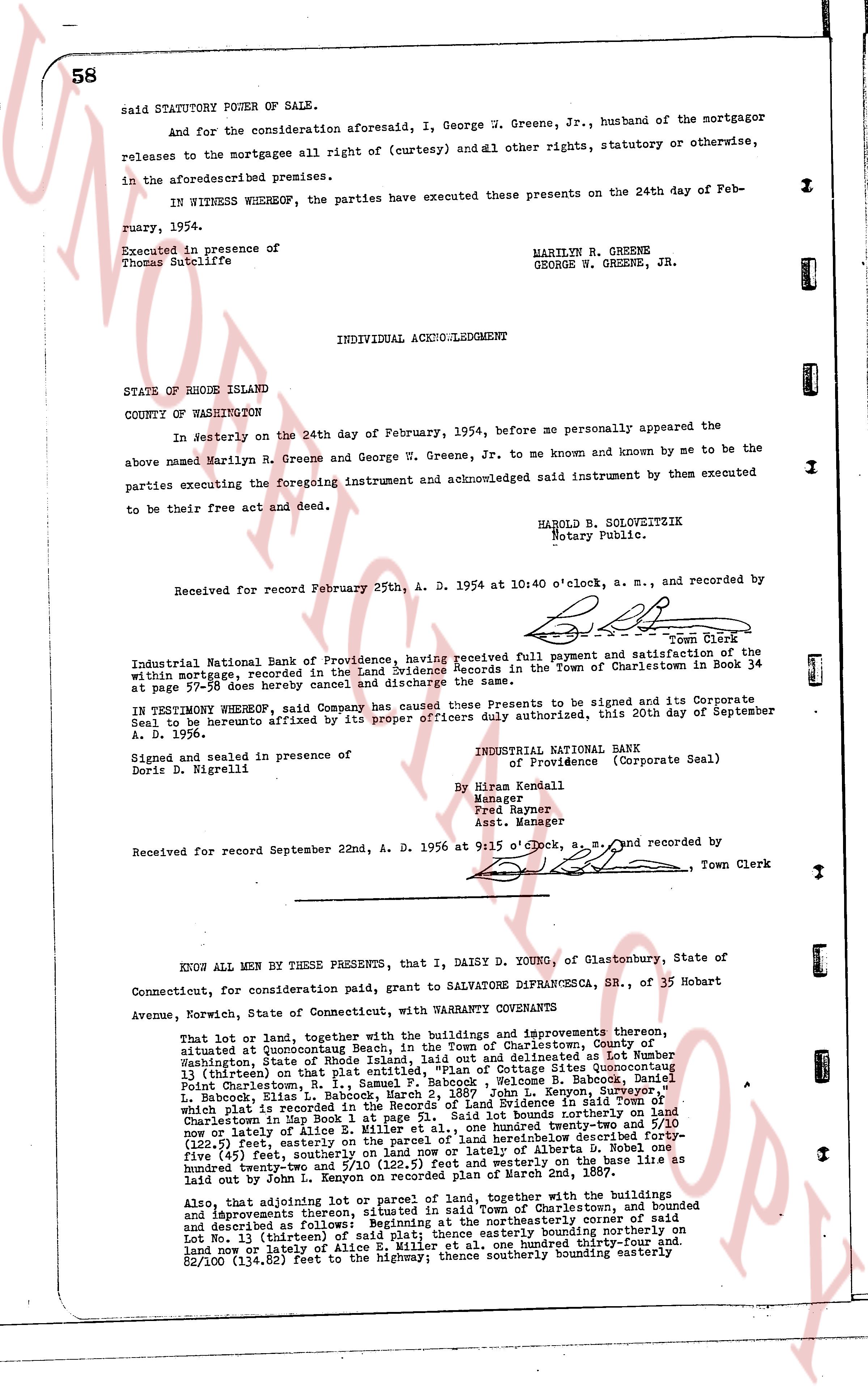
page 1

deed_walker_v1.9_2026-10-10 · the index is the town's own (i2l.uslandrecords.com); transcripts, chains and the assessor's cards are the Perry Machine's reading of it. Where the record we hold runs out, the page says so.