The instrument's own words
page 1 · read by Gemma vision
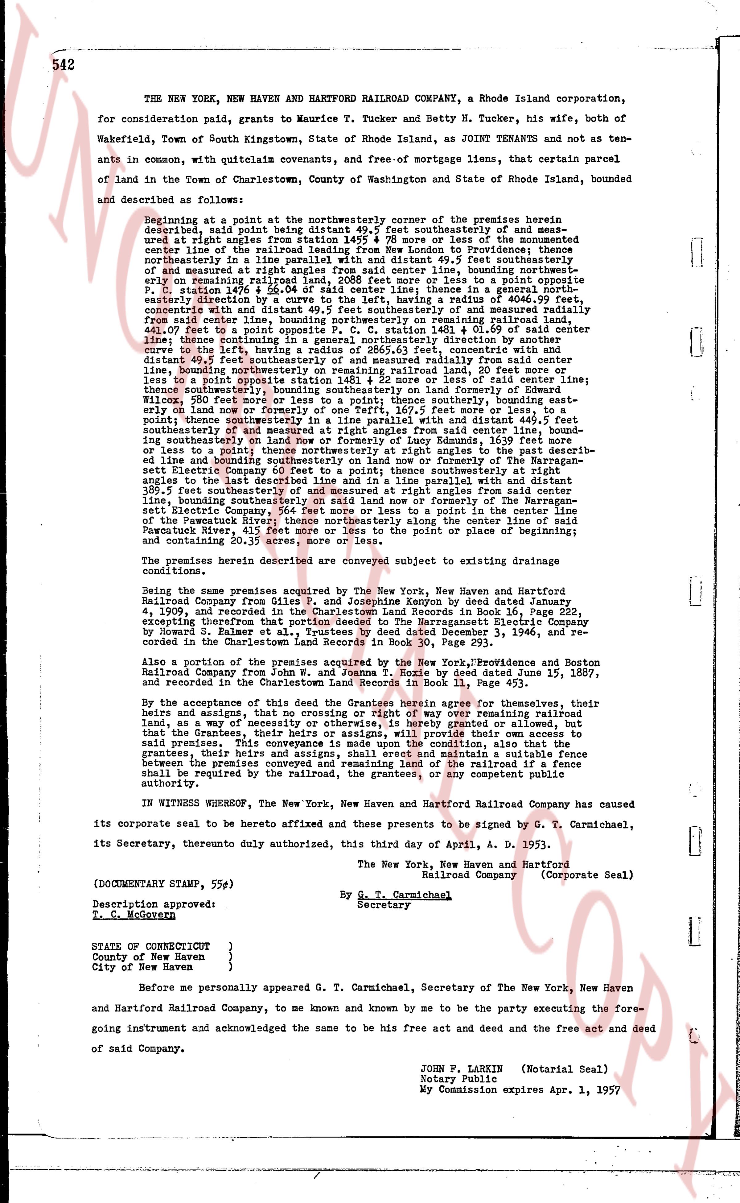
542
THE NEW YORK, NEW HAVEN AND HARTFORD RAILROAD COMPANY, a Rhode Island corporation, for consideration paid, grants to Maurice T. Tucker and Betty H. Tucker, his wife, both of Wakefield, Town of South Kingstown, State of Rhode Island, as JOINT TENANTS and not as tenants in common, with quitclaim covenants, free of mortgage liens, that certain parcel of land in the Town of Charlestown, County of Washington and State of Rhode Island, bounded and described as follows:
Beginning at a point at the northeasterly corner of the premises herein described, said point being distant 49.5 ft southeasterly of and measured under right angles from station 145.5 + 45.8 to ore of the monumented center lines of the railroad right of way, said point being 50 feet westerly from the northeasterly in a line parallel with and distant 49.5 ft southeasterly of and measured at right angles from said center line, bounding northeasterly on railway right of way remaining railroad land, 208.5 feet to a point opposite P. C. station 146 + 55.04 of said center line; thence in a general northeasterly direction to the beginning of a curve with a radius of 806.99 ft, concentric with and distant 49.5 ft southeasterly of and measured at right angles from said center line, bounding northeasterly on railway right of way remaining railroad land, 144.41 feet to a point opposite P. C. station 148.01 + 01.69 of said center line; thence continuing along said curve, continuing the curve to the left, having a radius of 2865.63 ft, concentric with and distant 49.5 ft southeasterly of and measured at right angles from said center line, bounding northeasterly on remaining railroad land, 20 feet more or less to a point opposite P. C. station 149.01 + 01.69 of said center line; thence continuing along said curve, bounding southeasterly on remaining railroad land of the former New York New Haven and Hartford Railroad Company, 200 feet to a point opposite P. C. station 150.01 + 01.69 of said center line; thence southeasterly, bounding southeasterly on land owned by Edward F. Seely; thence southeasterly on boundary between said Seely's land and land of the Narragansett Electric Company 60 feet to a point; thence southeasterly at right angles to the closest line described herein and in a line parallel with and distant 49.5 feet southeasterly of and measured at right angles from said center line, bounding southeasterly on said land now or formerly of the Narragansett Electric Company, bounding southeasterly on said land now or formerly of the Narragansett Electric Company, 111.5 feet to a point on the center line of said land, thence northeasterly along the center line of said point in the center line of the Pawcatuck River; thence northeasterly along the center line of said river to the point of or place of beginning; and containing 20.35 acres, more or less.
The premises herein described are conveyed subject to existing drainage conditions.
Being the same premises acquired by The New York, New Haven and Hartford Railroad Company from Giles P. and Josephine Kenny by deed dated January 4, 1909, and recorded in the Charlestown Land Evidence Record in Book 14, Page 552, excepting therefrom that portion deeded to the Narragansett Electric Company by Howard F. Palmer by deed dated and recorded December 3, 1946, and recorded in the Charlestown Land Records in Book 30, Page 293.
Also a portion of the premises acquired by the New York, Providence and Boston Railroad Company from John W. and Joanna T. Hoyle by deed dated June 18, 1897, and recorded in the Charlestown Land Evidence Record in Book 11, Page 292.
By the acceptance of this deed the Grantees herein agree for themselves, their heirs and assigns, that no crossing or right of way over remaining railroad land, as a way of access to the premises hereby granted or allowed but that the Grantees, their heirs or assigns, will provide their own access to said premises. This covenant is a condition of this conveyance, and that to the grantees, their heirs or assigns, shall erect and maintain a suitable fence between the premises hereby conveyed and the railroad right of way where a place shall be required by the railroad, the grantees, or any competent public authority.
IN WITNESS WHEREOF, The New York, New Haven and Hartford Railroad Company has caused its corporate seal to be hereto affixed and these presents to be signed by G. T. Carmichael, its Secretary, therefore duly authorized, this third day of April, A. D. 1953.
The New York, New Haven and Hartford Railroad Company (Corporate Seal)
By G. T. Carmichael
Secretary
(DOCUMENTARY STAMP, 55¢)
Description approved:
T. C. McGovern
STATE OF CONNECTICUT
County of New Haven
City of New Haven }
Before me personally appeared G. T. Carmichael, Secretary of The New York, New Haven and Hartford Railroad Company, to me and known by me and to me be the party executing the foregoing instrument and acknowledged the same to be his free act and deed and that of said Company.
JOHN F. LARKIN (Notarial Seal)
Notary Public
My Commission expires Apr. 1, 1957
page 2 · read by Gemma vision
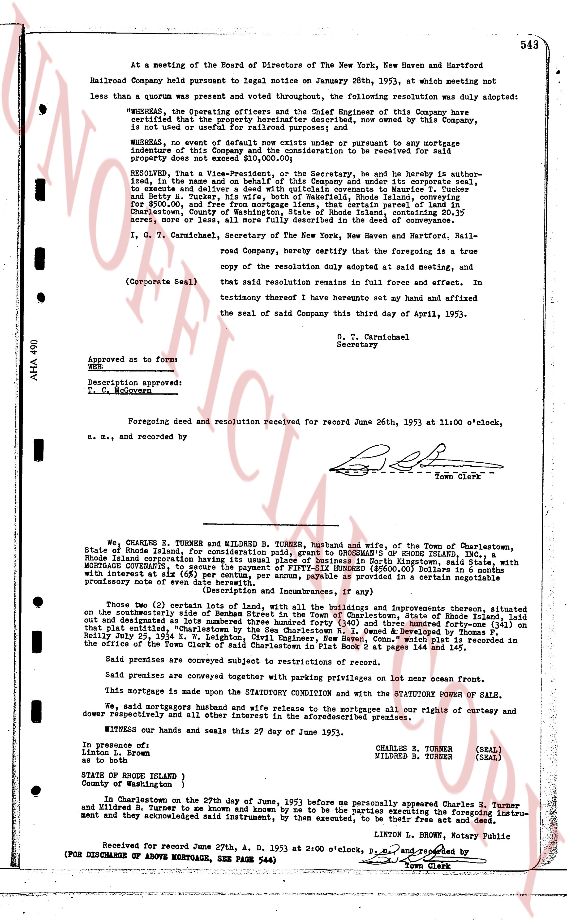
At a meeting of the Board of Directors of The New York, New Haven and Hartford
Railroad Company held pursuant to legal notice on January 28th, 1953, at which meeting not
less than a quorum was present and voted throughout, the following resolution was duly adopted:
"WHEREAS, the Operating officers and the Chief Engineer of this Company have
certified that the property hereinafter described, now owned by this Company, is
not used or useful for railroad purposes; and
WHEREAS, no event of default now exists nor would ensue pursuant to and or any mortgage
indenture of this Company and the consideration to be received for said
property does not exceed $10,000.00;
RESOLVED, That the Vice-President, and be Secretary, be and he is hereby author-
ized, in the name, and on behalf of this Company and under its corporate seal,
to execute and deliver a deed with appropriate warranties to Maurice T. Tucker
and Betty H. Tucker, his wife, both of Wakefield, Rhode Island, conveying
for $900.00, all right, title and interest in a certain parcel of land situated in
Charlestown, County of Washington, State of Rhode Island, containing 20.35
acres, more or less, all more fully described in the deed of conveyance."
I, G. T. Carmichael, Secretary of The New York, New Haven and Hartford Rail-
road Company, hereby certify that the foregoing is a true
copy of the resolution duly adopted at said meeting, and that
said resolution remains in full force and effect. And in
testimony hereof I have hereunto set my hand and affixed
the seal of said Company this third day of April, 1953.
(Corporate Seal) G. T. Carmichael
Secretary
Approved as to form:
W&B
Description approved:
F. M. Holowcrmer
Foregoing deed and resolution received for record June 26th, 1953 at 11:00 o'clock,
a. m., and recorded by [Signature]
Town Clerk
----
We, CHARLES E. TURNER and MILBRED B. TURNER, husband and wife, of the Town of Charlestown,
State of Rhode Island, for consideration paid, grant to GROSSMAN'S OF RHODE ISLAND, INC., a
Rhode Island corporation having its usual place of business in North Kingstown, said State, with
MORTGAGE CONVEYANCE, to secure the payment of the sum of TWO THOUSAND DOLLARS ($2,000.00)
with interest at six (6%) per centum, per annum, payable as provided in a certain negotiable
promissory note of date hereof.
(Description and Incumbrances, if any)
Those two (2) certain lots of land, with all the buildings and improvements thereon, situated
on the southeasterly side of South Beach street, in the Town of Charlestown, State of Rhode Island, laid
out and designated as lots numbered three hundred forty (340) and three hundred forty-one (341) on
the said street, "Charlestown" as shown on the Charlestown R. I. Town Map developed by Thomas F.
Reilly, July 25th, 1944, K. W. Leighton, Civil Engineer, and more fully described as recorded in
the office of the Town Clerk of said Charlestown in Plat Book 2 at pages 144 and 145.
Said premises are conveyed subject to restrictions of record.
Said premises are conveyed together with parking privileges on 10t lot near ocean front.
This mortgage is made upon the STATUTORY CONDITION and with the STATUTORY POWER OF SALE.
We, said mortgagors and husband and wife release to the mortgagees all our rights of curtesy and
dower respectively and all other interest in the aforementioned premises.
WITNESS our hands and seals and set this 27 day of June 1953.
CHARLES E. TURNER (SEAL)
MILBRED B. TURNER (SEAL)
In presence of:
Linton L. Brown
as to form
STATE OF RHODE ISLAND )
County of Washington )
In Charlestown on the 27th day of June, 1953 before me personally appeared Charles E. Turner
and Milbred B. Turner, to me known and by me known to be the parties executing the foregoing instru-
ment and acknowledged said instrument, by them executed, to be their free act and deed.
LINTON L. BROWN, Notary Public
Received for record June 27th, A. D. 1953 at 2:00 o'clock, P.M. and recorded by [Signature]
(FOR DISCHARGE OF ABOVE MORTGAGE, SEE PAGE 544) Town Clerk
The page as recorded