The Deed Walker · From Ninigret · Charlestown, Rhode Island land evidence, 1738 to today
Trail: 5404@36/64 › 3446@33/439 › 3457@33/452

3/30/1953 · DEED · book 33 page 452 doc 3457@33/452

From PENDLETON ALFRED S, PENDLETON MARY E life
To BROWN PHYLLIS T
Premises Two tracts of land (Charlestown)

Back — where this land came from

deed Ezra S. Fuller book 33 p 439 Charlestown
“Being the same premises conveyed by deed of Ezra S. Fuller to the transgrantor”
◀ Follow back 1953 · DEED · ALLEN ARTHUR E; ALLEN ARTHUR ERNEST; ALLEN BARBARA MAY; BUTTON BERNICE → HOLBERTON MADELINE; HOLBERTON RANDOLPH · book 33 p 439
read by: gemma

The grantor's earlier acquisitions, by name — the man, not necessarily this land

◀ 1953 · DEED · BROWN PHYLLIS T → JENKINS FOSTER M; JENKINS MARION L; PENDLETON ALFRED S; PENDLETON MARY · book 33 p 453
◀ 1952 · DEED · FULLER JESSIE E → PENDLETON ALFRED S; PENDLETON MARY E · book 33 p 69
◀ 1950 · DEED · CHARLESTOWN TOWN OF; MARSDEN LOUIS; MARSDEN SARAH → PENDLETON ALFRED S; PENDLETON MARY E · book 32 p 300
◀ 1928 · DEED · TAYLOR JOHN E; TAYLOR EMILY → PENDLETON ALFRED S; PENDLETON MARY E · book 23 p 204

Forward — where this land went

Follow forward ▶ 1953 · DEED · BROWN PHYLLIS T → JENKINS FOSTER M; JENKINS MARION L; PENDLETON ALFRED S; PENDLETON MARY · book 33 p 453
“Being the same premises conveyed by Deed of Alfred S. Pendleton et ux to this Grantor”
cites this instrument as its source · read by gemma

The grantee's later conveyances, by name — the man, not necessarily this land; the one that cites this deed as its source is the land

▶ 1953 · DEED · BROWN PHYLLIS T → JENKINS FOSTER M; JENKINS MARION L; PENDLETON ALFRED S; PENDLETON MARY · book 33 p 453
▶ 1953 · DEED · BROWN PHYLLIS T → PROSSER GEORGE H; PROSSER RUFUS K · book 33 p 591
▶ 1956 · DEED · BROWN PHYLLIS T → GRINNELL LEON M · book 35 p 498
▶ 1956 · DEED · BROWN PHYLLIS T → MURTAGH HATTIE E · book 35 p 498
▶ 1958 · DEED · BROWN PHYLLIS T → FERRETTI ANTONIO; FERRETTI MARGARET I; FERRETTI SAM · book 36 p 307
▶ 1959 · DEED · BROWN PHYLLIS T → JORDAN HARRIET H; LAMPHERE HAROLD E · book 37 p 18
▶ 1981 · DEED · BROWN PHYLLIS T → THIBAULT EDNA F; THIBAULT GEORGE J · book 66 p 564
▶ 1982 · CERTIFICATE · BROWN PHYLLIS T → · book 68 p 133
▶ 1982 · MORTGAGE · BROWN PHYLLIS T → WASHINGTON TRUST COMPANY · book 68 p 134
▶ 1982 · CERTIFICATE · BROWN PHYLLIS T → · book 68 p 140
▶ 1982 · DEED · BROWN PHYLLIS T → JAMES NORMAN H · book 68 p 141
▶ 1982 · CERTIFICATE · BROWN PHYLLIS T → · book 67 p 607
▶ 1982 · MORTGAGE · BROWN PHYLLIS T → WASHINGTON TRUST COMPANY · book 67 p 608
▶ 1985 · CERTIFICATE · BROWN PHYLLIS T → · book 78 p 299
▶ 1985 · MORTGAGE · BROWN PHYLLIS T → WASHINGTON TRUST COMPANY · book 78 p 300
▶ 1987 · AGREEMENT · BROWN PHYLLIS T; WASHINGTON TRUST COMPANY → WASHINGTON TRUST COMPANY; BROWN PHYLLIS T · book 93 p 112

The instrument's own words

page 1 · read by Gemma vision
452 We, Alfred S. Pendleton and Mary E. Pendleton, husband and wife, both of the Town of Charlestown, County of Washington, State of Rhode Island, for consideration paid, grant to PHYLLIS T. BROWN, of said Town and State, with QUIT-CLAIM COVENANTS Those certain parcels or tracts of land, situated in the Town of Charlestown, County of Washington, State of Rhode Island, bounded and described as follows: FIRST TRACT: Beginning at a stake in the ground at the highest part of the beach bank and running by the shore of the lot herein conveyed; thence northerly seventy (70) feet, to a stake in the ground; thence west- erly forty (40) feet to a stake in the ground; thence southerly seven- ty (70) feet to a stake in the ground at the beach bank; thence east- erly forty (40) feet to the place of beginning. Together with a right to pass and repass either with tenants or on foot across the land, now or formerly of, Stillings D. Masoncome, and also a right of way four (4) feet wide, for the purpose of passing on foot from the tract herein conveyed to the ocean. SECOND TRACT: Beginning at a given point on the northeast Corner of a land, formerly of Louis R. Raucher, measuring forty (40) feet; thence north- erly sixty (60) feet; thence easterly thirty-five (35) feet; thence south- erly sixty (60) feet, more or less, to the point and place of begin- ning, bounded on the north by the land of Ezra S. Fuller; on the south- west by land formerly of Marriet Mason; on the north by the Town Highway and on the east by land of Louis R. Raucher, Buddington or other other- wise the same may be bounded or described. Being the same premises conveyed by deed of Ezra S. Fuller to the trans- grantor, said deed being dated the 23rd day of June, 1952 and recorded in the Records of Land Evidence, said Town of Charlestown, in Book No. 33 at Page 439. Reference to said deed and records thereof being hereby had and made and the same made a part hereof for a more complete and detailed description of the premises hereby conveyed. WITNESS our hands this 30th day of March, 1953. MARY E. PENDLETON ALFRED S. PENDLETON No Internal Revenue Stamps required. STATE OF RHODE ISLAND, ETC.) ) County of Washington } In Charlestown, on the 30th day of March, 1953, before me personally appeared Alfred S. Pendleton and Mary E. Pendleton, husband and wife, both to me known and known by me to be the parties executing the foregoing instrument, and they acknowledged said instrument, by them executed, to be their free act and deed. LIBTON L. BROWN Notary Public Received for record March 30th, A.D. 1953 at 9:00 o'clock, a. m., and recorded by [Signature] Town Clerk

The page as recorded
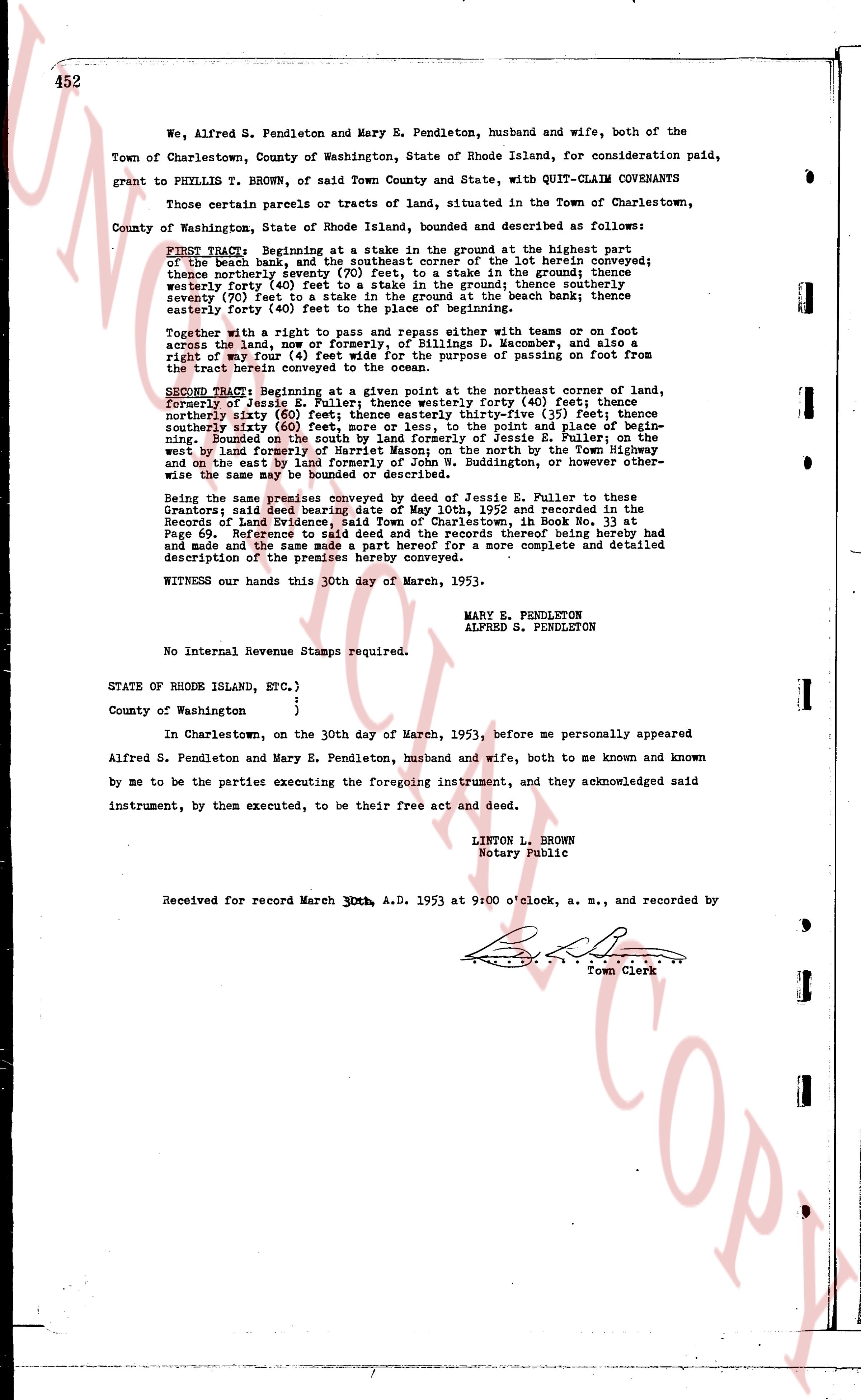
page 1

deed_walker_v1.9_2026-10-10 · the index is the town's own (i2l.uslandrecords.com); transcripts, chains and the assessor's cards are the Perry Machine's reading of it. Where the record we hold runs out, the page says so.