The Deed Walker · From Ninigret · Charlestown, Rhode Island land evidence, 1738 to today
Trail: 1000@29/417 › 3109@33/37

4/8/1952 · DEED · book 33 page 37 doc 3109@33/37

From SQUIER LEONARD K, SQUIER MARGARET B
To DALE DOROTHY A
Premises .2562 square feet · Parcel on Daventry Street, easterly part of lots 1054, 1053, 1052 (Charlestown by the Sea, Charlestown)
Index description DAVENTRY ST

Back — where this land came from

This instrument states no source of title that we have read yet.

The grantor's earlier acquisitions, by name — the man, not necessarily this land

◀ 1952 · DEED · GODDEN GLENN F; GODDEN MILDRED A → SQUIER LEONARD K; SQUIER MARGARET B · book 33 p 18
◀ 1951 · DEED · WEISS ANNA; WEISS ELMER M; WEISS ELMER MAX → GRINNELL LEON M; SQUIER LEONARD K · book 32 p 465
◀ 1951 · DEED · GRINNELL LEON M; GRINNELL PEARL M → SQUIER LEONARD K; SQUIER MARGARET B · book 32 p 588
◀ 1949 · DEED · TINGLEY EDGAR B → SQUIER LEONARD K; SQUIER MARGARET B · book 31 p 468
◀ 1949 · DEED · CHARLESTOWN TOWN OF; DUNN GRETTA K → GRINNELL LEON; SQUIER LEONARD K · book 31 p 664
◀ 1949 · DEED · CHARLESTOWN TOWN OF; HERBERT LILLIAN E → SQUIER LEONARD K; GRINNELL LEON · book 31 p 665
◀ 1949 · DEED · CHARLESTOWN TOWN OF; DUNN GRETTA K → GRINNELL LEON; SQUIER LEONARD K · book 31 p 666
◀ 1948 · DEED · WILSON ELIZABETH; WILSON ISAAC → GRINNELL LEON M; SQUIER LEONARD K · book 31 p 109
◀ 1948 · DEED · BAUER HARRIET E P → GRINNELL LEON M; SQUIER LEONARD K · book 31 p 225
◀ 1948 · DEED · CHASE BENJAMIN ELLERY; CHASE GLADYS W → GRINNELL LEON M; SQUIER LEONARD K · book 31 p 241
◀ 1948 · ASSIGNMENT · BROWN LINTON L; WEISS ELMER M → GRINNELL LEON M; SQUIER LEONARD K · book 31 p 251
◀ 1948 · DEED · HULL MARY L; HULL MABLE CLARK EST; HULL ROBERT E EST → SQUIER LEONARD K; SQUIER MARGARET B · book 30 p 640
◀ 1945 · DEED · KING WILLIAM J → SQUIER LEONARD K; SQUIER MARGARET BURR · book 29 p 417
◀ 1944 · DEED · WALSH WILLIAM E; WALSH AMEY E → SQUIER MARGARET B · book 29 p 213

Forward — where this land went

Follow forward ▶ 1961 · DEED · WEST CECELIA H; WEST DONALD → WEST MARCIA CECELIA · book 38 p 109
“being the same premises conveyed by deed of Earl C. Fisher and Ada C. Fisher... recorded... in Book No. 33, Page 37.”
cites this instrument as its source · read by gemma

The grantee's later conveyances, by name — the man, not necessarily this land; the one that cites this deed as its source is the land

▶ 1952 · MORTGAGE · DALE DOROTHY A → PROVIDENCE TEACHERS CREDIT UNION · book 33 p 38
▶ 1982 · DEED · DALE DOROTHY A → DOWNING DEBORAH M; SOMERS THOMAS DALE · book 69 p 656
▶ 1982 · DEED · DALE DOROTHY A → DOWNING DEBORAH M; SOMERS DAVID H; SOMERS THOMAS DALE · book 69 p 657

Today — the assessor's parcel

1 DAVENTRY STREET map 9 lot 212
owner of record: DOWNING EDWARD T + DEBORAH S · SEASONAL
the assessor cites book/page 0033/0037 (DALE, DOROTHY A, 01/01/1900)
05/12/1998DOWNING EDWARD T + DEBORAH Sbook 167 p 592
07/08/1994SOMERS, THOMAS D & DAVID H &book 139 p 984
12/28/1982SOMERS, THOMAS D & DAVID H &book 69 p 657
01/01/1900DALE, DOROTHY Abook 33 p 37
the assessor's card ↗

The instrument's own words

page 1 · read by Gemma vision
37 MARGARET B. SQUIER, of the Town of Charlestown, County of Washington, State of Rhode Island for consideration paid, grant to Dorothy A. Dale, of the City and County of Providence, State of Rhode Island with WARRANTY COVENANTS (Description, and Incumbrances, if any) That certain parcel of land located in the Town of Charlestown with all the buildings and improvements thereon described as follows: Beginning at a point marked by an iron pipe driven in the ground on the southerly line of Daventry Street, said point being the southerly boundary of the machinery corner lot No. 92 as shown on a plat entitled "Charlestown by the Sea, owned and developed by Thomas F. Reilly, location Charlestown, Rhode Island, scale 1" = 100', dated July 25, 1934, by H. Leighton, Civil Engineer, New Haven, Conn.", said plat is on file in the office of the Town Clerk for said Charlestown; thence running in a southerly direction more or less an azimuth of 160° 00' from said southerly line of Daventry Street a distance of 70.12 feet to an iron pipe; thence turning an interior angle of 95° 15' and running south 55° 15' east a distance of 68.31 feet to an iron pipe; thence turning an interior angle of 90° 15' and running north-easterly a distance of 65.17 feet to an iron pipe set in the southerly line of Daventry Street; thence turning an interior angle of 92° 03' and running easterly along said southerly line of Daventry Street a distance of 111.11 feet, then 65.64 feet to the point and place of beginning. This tract containing an area of .2562 square feet. The above described tract is the easterly part of lots 1054, 1053 and part of lot 1052 as shown on the above mentioned plat. It is to be understood that the garage located at the southeast corner of the described premises is a part of lot 1052, having a common boundary wall. Said common wall is located on the western boundary line of the described premises and is to be used jointly by the owner of the described premises and the grantee. This conveyance carries with it all parking privileges appurtenant to said land. This conveyance is made subject to restrictions of record. This conveyance is made subject to taxes assessed December 31, 1951. Leonard K. Squier husband of the grantor release to said grantee all my right of curtesy and all other interest in the aforesaid described premises. WITNESS our hands this 4th day of April 1952. MARGARET B. SQUIER LEONARD K. SQUIER (DOCUMENTARY STAMPS, $4.40) STATE OF RHODE ISLAND, ETC.) ) County of Washington ) In Charlestown on the 4th day of April, 1952 before me personally appeared Margaret B. Squier and Leonard K. Squier to me known and known by me to be the parties executing the foregoing instrument, and they acknowledged said instrument, by them executed, to be their free act and deed. LINTON L. BROWN Notary Public. Received for record April 8th, A. D. 1952 at 9:30 o'clock, a. m., and recorded by [Signature] Town Clerk

The page as recorded
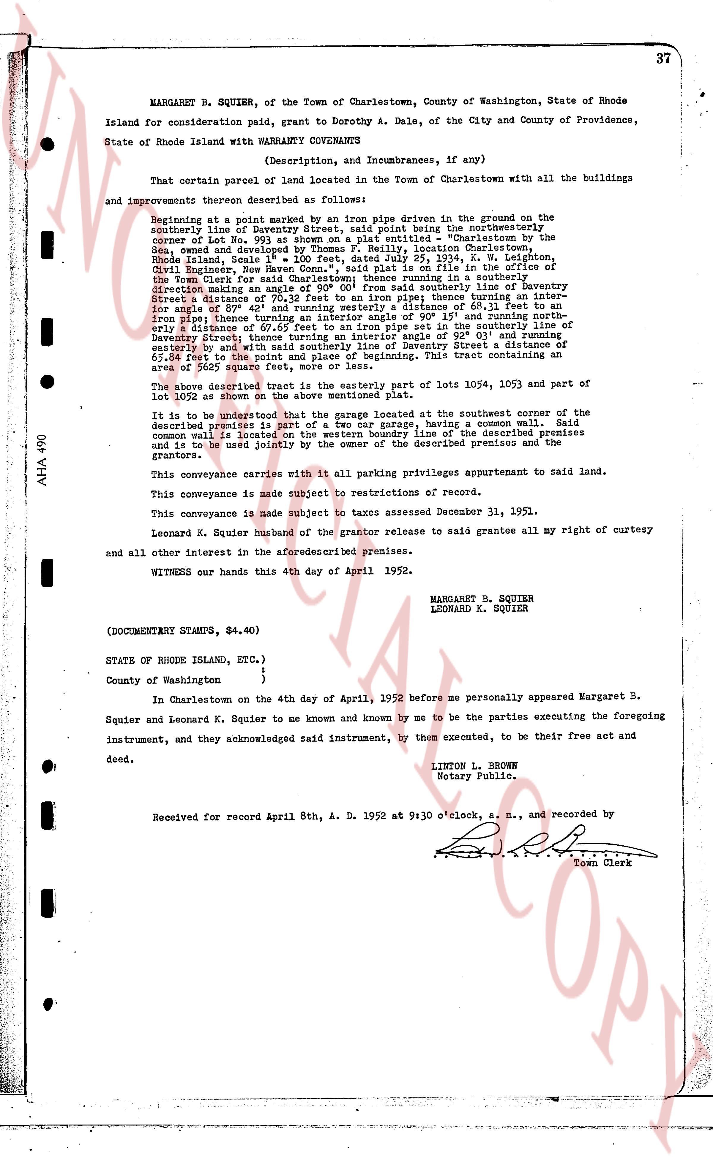
page 1

deed_walker_v1.9_2026-10-10 · the index is the town's own (i2l.uslandrecords.com); transcripts, chains and the assessor's cards are the Perry Machine's reading of it. Where the record we hold runs out, the page says so.