The Deed Walker · From Ninigret · Charlestown, Rhode Island land evidence, 1738 to today
Trail: 8930 › 8233 › 8961 › 30@29/639

4/15/1942 · EASEMENT · book 29 page 639 doc 30@29/639

From STRAYER GERTRUDE L
To NARRAGANSETT ELECTRIC COMPANY
Premises five (5) acres · tract bounded by a path/driveway and South County Public Service Company fence (Charlestown, Pasquisset Pond)
Index description SEE DOC
Also on this page: EASEMENT NARRAGANSETT ELECTRIC COMPANY

Back — where this land came from

This instrument states no source of title that we have read yet.

The grantor's earlier acquisitions, by name — the man, not necessarily this land

◀ 1940 · DEED · HOXSIE BETTY B; HOXSIE LUCILLE J; HOXSIE W MUNROE; HOXSIE W MUNROE JR → STRAYER GERTRUDE L · book 28 p 189
◀ 1939 · MORTGAGE DISCHARGE · QUONY REALTY CORPORATION → STRAYER GERTRUDE L · book 27 p 291
◀ 1938 · DEED · QUONY REALTY CORPORATION → STRAYER GERTRUDE L · book 27 p 290
◀ 1936 · MORTGAGE DISCHARGE · QUONY REALTY CORP → STRAYER GERTRUDE L · book 25 p 701
◀ 1931 · MORTGAGE · QUONY REALTY CORP → STRAYER GERTRUDE L · book 25 p 23

Forward — where this land went

The grantee's later conveyances, by name — the man, not necessarily this land; the one that cites this deed as its source is the land

▶ 1948 · MORTGAGE · NARRAGANSETT ELECTRIC COMPANY → RHODE ISLAND HOSPITAL TRUST CO,TR · book 31 p 159
▶ 1952 · MORTGAGE · NARRAGANSETT ELECTRIC COMPANY → RHODE ISLAND HOSPITAL TRUST CO,TR · book 33 p 75
▶ 1963 · DEED · NARRAGANSETT ELECTRIC COMPANY; RHODE ISLAND HOSPITAL TRUST CO,TR → UNITED NUCLEAR CORP · book 39 p 169
▶ 1964 · MISC · NARRAGANSETT ELECTRIC COMPANY → RHODE ISLAND HOSPITAL TRUST CO,TR · book 39 p 426
▶ 1966 · RELEASE · NARRAGANSETT ELECTRIC COMPANY → WASHINGTON TRUST COMPANY EXECUTOR; ARNOLD THOMAS L EST; ARNOLD LYNDON, · book 40 p 650
▶ 1969 · MISC · NARRAGANSETT ELECTRIC COMPANY → RHODE ISLAND HOSPITAL TRUST CO,TR · book 43 p 103
▶ 1970 · MISC · NARRAGANSETT ELECTRIC COMPANY; RHODE ISLAND HOSPITAL TRUST NATIONAL BA → RHODE ISLAND HOSPITAL TRUST NATIONAL BANK; NARRAGANSETT ELECTRIC COMPA · book 44 p 99
▶ 1972 · MISC · NARRAGANSETT ELECTRIC COMPANY → RHODE ISLAND HOSPITAL TRUST NATIONAL BANK · book 45 p 516
▶ 1974 · AGREEMENT · NARRAGANSETT ELECTRIC COMPANY; RHODE ISLAND HOSPITAL TRUST NATIONAL BA → RHODE ISLAND HOSPITAL TRUST NATIONAL BANK; NARRAGANSETT ELECTRIC COMPA · book 51 p 73
▶ 1974 · AGREEMENT · NARRAGANSETT ELECTRIC COMPANY; RHODE ISLAND HOSPITAL TRUST NATIONAL BA → RHODE ISLAND HOSPITAL TRUST NATIONAL BANK; NARRAGANSETT ELECTRIC COMPA · book 50 p 95
▶ 1974 · MISC · NARRAGANSETT ELECTRIC COMPANY → RHODE ISLAND HOSPITAL TRUST NATIONAL BANK · book 49 p 470
▶ 1975 · AGREEMENT · NARRAGANSETT ELECTRIC COMPANY → RHODE ISLAND HOSPITAL TRUST NATIONAL BANK · book 52 p 187
▶ 1975 · LEAS · GLENN F GODDEN AGENCY; NARRAGANSETT ELECTRIC COMPANY → NARRAGANSETT ELECTRIC COMPANY; GLENN F GODDEN AGENCY · book 52 p 235
▶ 1980 · MORTGAGE · NARRAGANSETT ELECTRIC COMPANY → RHODE ISLAND HOSPITAL TRUST NATIONAL BANK · book 64 p 327
▶ 1982 · MORTGAGE · NARRAGANSETT ELECTRIC COMPANY → RHODE ISLAND HOSPITAL TRUST NATIONAL BANK · book 67 p 380
▶ 1984 · MISC · NARRAGANSETT ELECTRIC COMPANY → RHODE ISLAND HOSPITAL TRUST NATIONAL BANK · book 74 p 1

The instrument's own words

page 1 · read by Gemma vision
610 KNOW ALL MEN BY THESE PRESENTS, that we, ALVIN J. BAKER and MARGUERITE S. BAKER, husband and wife, both of North easton, County of Bristol, and State of Massachusetts for consideration paid paid, GRANT to SALMA ROSE, of the Town of Richmond, County of Washington and State of Rhode Island with WARRANTY CONVEYANCE That certain real estate situated in Charlestown, County of Washington, in the State of Rhode Island, and described as follows: A certain tract or parcel of land, situated in said Town of Charlestown, containing by estimation, five (5) acres, bounded and described as follows: Beginning at a point on the easterly side of a path or driveway leading from the State Highway Pasquisset Pond the northwest extremity of said path is approximately one or four hundred feet being nearly opposite the home of John J. Burdick. Said point being forty-five [?] feet south of the center line of said path; thence southerly one or four hundred feet to the South County Public Service Company fence; thence southerly bounded west-erly to said path or driveway by a straight line, a distance of four hundred twenty (420) feet; thence is in easterly direction a distance of five hundred twenty-seven (527) feet to the center line of said path, a line perpendicular to the boundary line between the premises of these Grantors and the premises of said J. Burdick; thence northerly a following the center line of said path to the boundary line a distance of four hundred twenty (420) feet; thence in a westerly direction in a straight line, a distance of five hundred twenty (520) feet to the point of beginning; bounded northerly and southerly by straight line of Grantors easterly by driveway or path or [?] by said path or driveway, or however otherwise the same may be bounded or described. This conveyance is subject to easement of the South County Public Service Company, of Providence, Rhode Island Clerk's Office of said easement. Said Grantee, her family and her heirs only, are hereby granted a right-of-way for foot traverse only across the premises of Grantors; said right-of-way to be four (4) feet distant from and parallel to the westerly boundary line as described above of Hilda Hummingbird and extending in a general southerly direction from said Pasquisset Path to said Pasquisset Pond. WITNESS our hands this 19th day of February 1937. ELVIN J. BAKER MARGUERITE S. BAKER (INTERNAL REVENUE STAMP, 50¢) STATE OF RHODE ISLAND } County of Washington } In Charlestown on the 19th day of February, 1937 before me personally appeared Alvin J. Baker and Marguerite S. Baker, husband and wife, both to me known and known by me to be the parties executing the foregoing instrument, and they acknowledged said instrument, by them executed, to be their free act and deed. LINTON L. BROWN Notary Public. Received for record February 19th, A. D. 1937 at 3:00 o'clock, p. m., and recorded by [Signature] Town Clerk.

The page as recorded
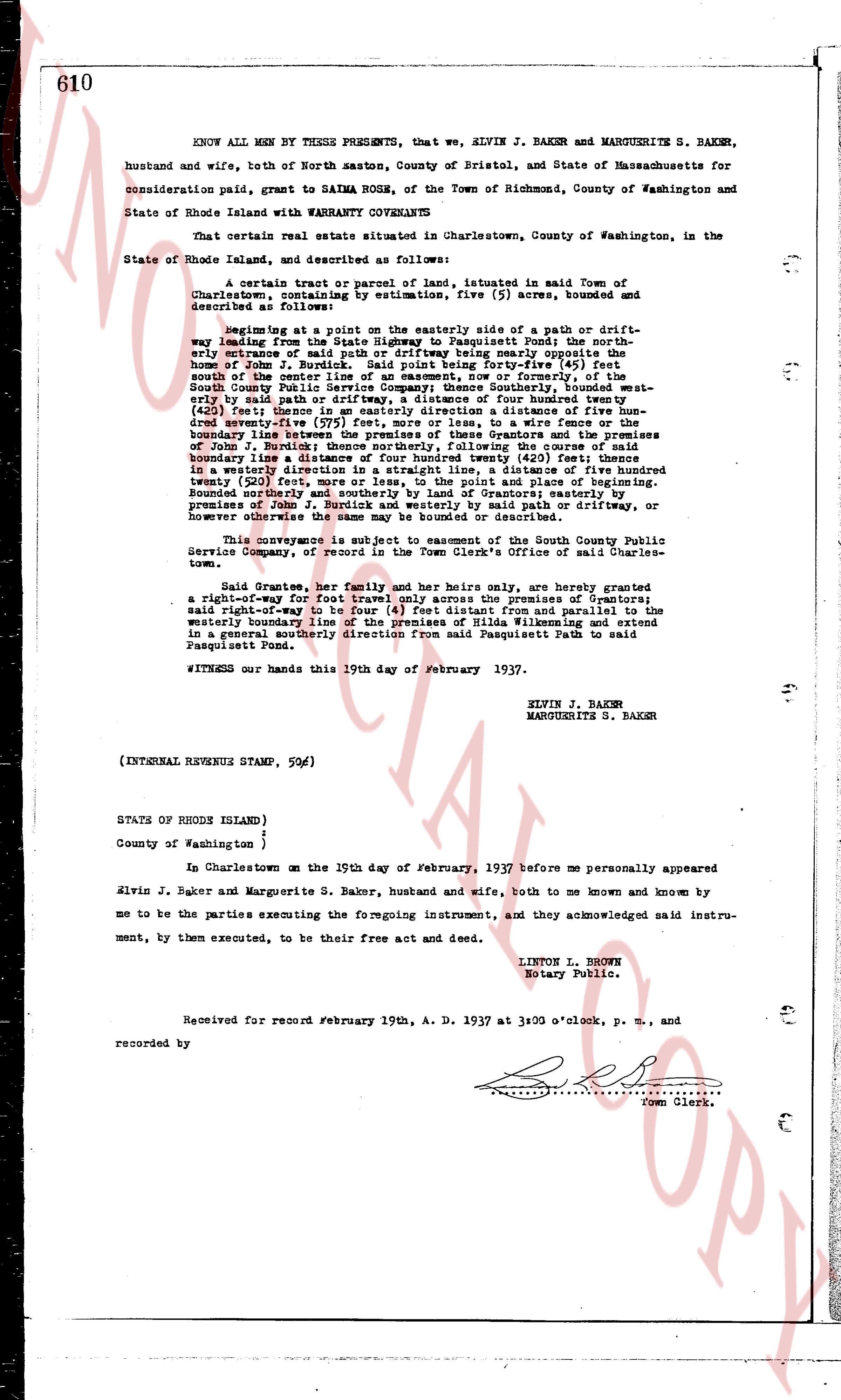
page 1

deed_walker_v1.9_2026-10-10 · the index is the town's own (i2l.uslandrecords.com); transcripts, chains and the assessor's cards are the Perry Machine's reading of it. Where the record we hold runs out, the page says so.