The instrument's own words
page 1 · read by Gemma vision
405
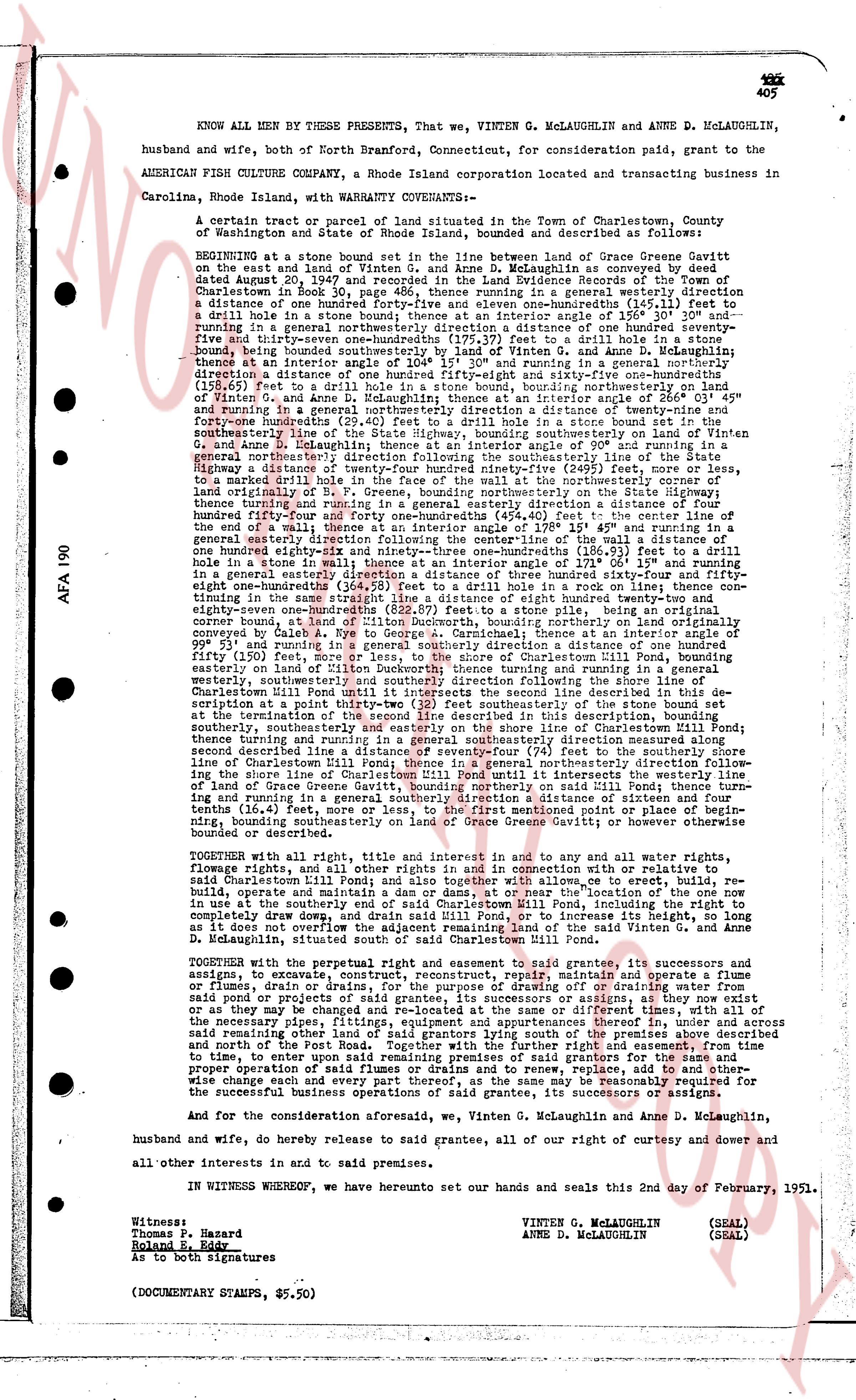
KNOW ALL MEN BY THESE PRESENTS, That we, VINTEN G. MCLAUGHLIN and ANNE D. MCLAUGHLIN, husband and wife, both of North Branford, Connecticut, for consideration paid, grant to the AMERICAN FISH CULTURE COMPANY, a Rhode Island corporation located and transacting business in Carolina, Rhode Island, with WARRANTY COVENANTS—
A certain tract or parcel of land situated in the Town of Charlestown, County of Washington and State of Rhode Island, bounded and described as follows:
BEGINNING at a stone bound set in the line between land of Grace Geneve Gavitt on the West and land of Vinten G. McLaughlin, as conveyed in a deed dated August 20, 1947 and recorded in the Land Evidence Records of the Town of Charlestown in Book 30, page 486, thence running in a general southeasterly direction a distance of one hundred fifty-four and seventy-one hundredths (154.71) feet to a drill hole in a stone bound; thence set in an interior angle of 150° 35' 30" and running in a general southeasterly direction a distance of one hundred fifty-one and seventy-five hundredths (151.75) feet to a drill hole in a stone bound; thence set in an interior angle of 104° 15' 30" and running in a general southeasterly direction a distance of one hundred fifty-eight and sixty-five hundredths (158.65) feet to a drill hole in a stone bound, running generally northerly on land of Vinten G. McLaughlin; thence set in an interior angle of 104° 15' 30" and running in a general northerly direction a distance of twenty-nine and forty-four hundredths (29.44) feet to a drill hole in a stone bound; thence running in a general southeasterly direction following the southeasterly line of the State Highway, bounding southeasterly on land of Vinten G. McLaughlin, a distance of one hundred twenty-four and seventy-one hundredths (124.71) feet to a drill hole in a stone bound; thence running in a general northeasterly direction following the southeasterly line of the State Highway, bounding southeasterly on land of Vinten G. McLaughlin, a distance of one hundred twenty-four and seventy-one hundredths (124.71) feet to a marked drill hole in the face of the wall at the northwesterly corner of land originally of S. F. Greene, bounding northerly on the State highway; thence running in a general northerly direction a distance of one hundred fifty-four and forty-four hundredths (154.44) feet to the center line of the one hundred fifty-four and forty-four hundredths (154.44) foot wide State Highway; thence running in a general easterly direction following the centerline of the wall a distance of one hundred fifty-four and seventy-one hundredths (154.71) feet to a drill hole in a stone wall in a stone fence; thence set in an interior angle of 171° 06' 15" and running in a general southeasterly direction a distance of one hundred fifty-four and eighty-one hundredths (154.81) feet to a drill hole in a rock in line thence continuing in a general southeasterly direction a distance of one hundred fifty-four and eighty-one hundredths (154.81) feet (822.67) feet to a stone pile, being an original corner of land originally of S. F. Greene, bounding southeasterly on land originally of S. F. Greene, as conveyed by Caleb A. Rye to George A. Carmichael; thence set in an interior angle of 90° 00' 00" and running in a general southwesterly direction a distance of one thousand one hundred fifty (1150) feet, more or less, to the shore of Charlestown Mill Pond, bounding easterly on land of Vinten G. McLaughlin; thence running in a general southwesterly direction, westerly, southeasterly and southeasterly direction following the shore line of Charlestown Mill Pond until it intersects the second line described in this description, bounding southwesterly to a point in the shore line of Charlestown Mill Pond; thence running in a general northeasterly direction a distance of one thousand one hundred fifty (1150) feet, more or less, to the termination of the second line described in this description, bounding southeasterly on land of Vinten G. McLaughlin and bounding northwesterly on land of Grace Geneve Gavitt; thence turning and running in a general northeasterly direction measured along the shore line of Charlestown Mill Pond a distance of one hundred fifty-four and seventy-one hundredths (154.71) feet to the center line of Charlestown Mill Pond; thence turning in a general northeasterly direction following the shore line of Charlestown Mill Pond, bounding northerly on said Mill Pond; thence turning and running in a general northeasterly direction a distance of one hundred fifty-four and seventy-one hundredths (154.71) feet, more or less, to the first mentioned point or place of beginning, running southeasterly on land of Grace Geneve Gavitt or otherwise however bounded or described.
TOGETHER with all right, title and interest in and to and pay all other water rights, fishing rights, and all other rights and privileges appertaining thereto or in any way related to said Charlestown Mill Pond; and also together with all powers to erect, to build, rebuild, operate and maintain a dam or dams at or near the location of the one now in or under the southeasterly shore of said Mill Pond, and to maintain, repair, rebuild, operate and drain, and drain said Mill Pond, or to increase its height, so long as it does not overflow the boundaries of the land of Vinten G. McLaughlin and Anne D. McLaughlin, situated south of said Charlestown Mill Pond.
TOGETHER with the perpetual right and easement to grant said easements to its successors and assigns, to construct, maintain and operate a road, way, walkway and operate a fence or ditches, drain dams, or the purpose of drawing or draining water from said pond or project provided that such road, way, walkway, fence or ditches, drain dams or as may be changed and re-located at the same center or different times, with all of the necessary pipes, culverts, bridges and other structures as may be required, over land of said remaining other land of said grantors lying south of the premises above described and north of the river pipes, and to maintain and repair the same and to replace the same from time to time, to enter upon said remaining premises of said grantors for the same and other proper operation of said roads, ways, fences and drains, and to remove, replace, add to and other wise change and enjoy every part thereof, and for the same pay to be determined and for the successful business operations of said grantee, its successors or assigns.
And for the consideration aforesaid, we, Vinten G. McLaughlin and Anne D. McLaughlin, husband and wife, do hereby release to said grantee, all of our right of curtesy and dower and all other interests in and to said premises.
IN WITNESS WHEREOF, we have hereunto set our hands and seals this 2nd day of February, 1951.
Witness:
Thomas P. Hazard
Island Rate
As to both signatures
VINTEN G. MCLAUGHLIN (SEAL)
ANNE D. MCLAUGHLIN (SEAL)
(DOCUMENT STAMPS, $5.50)
page 2 · read by Gemma vision
406
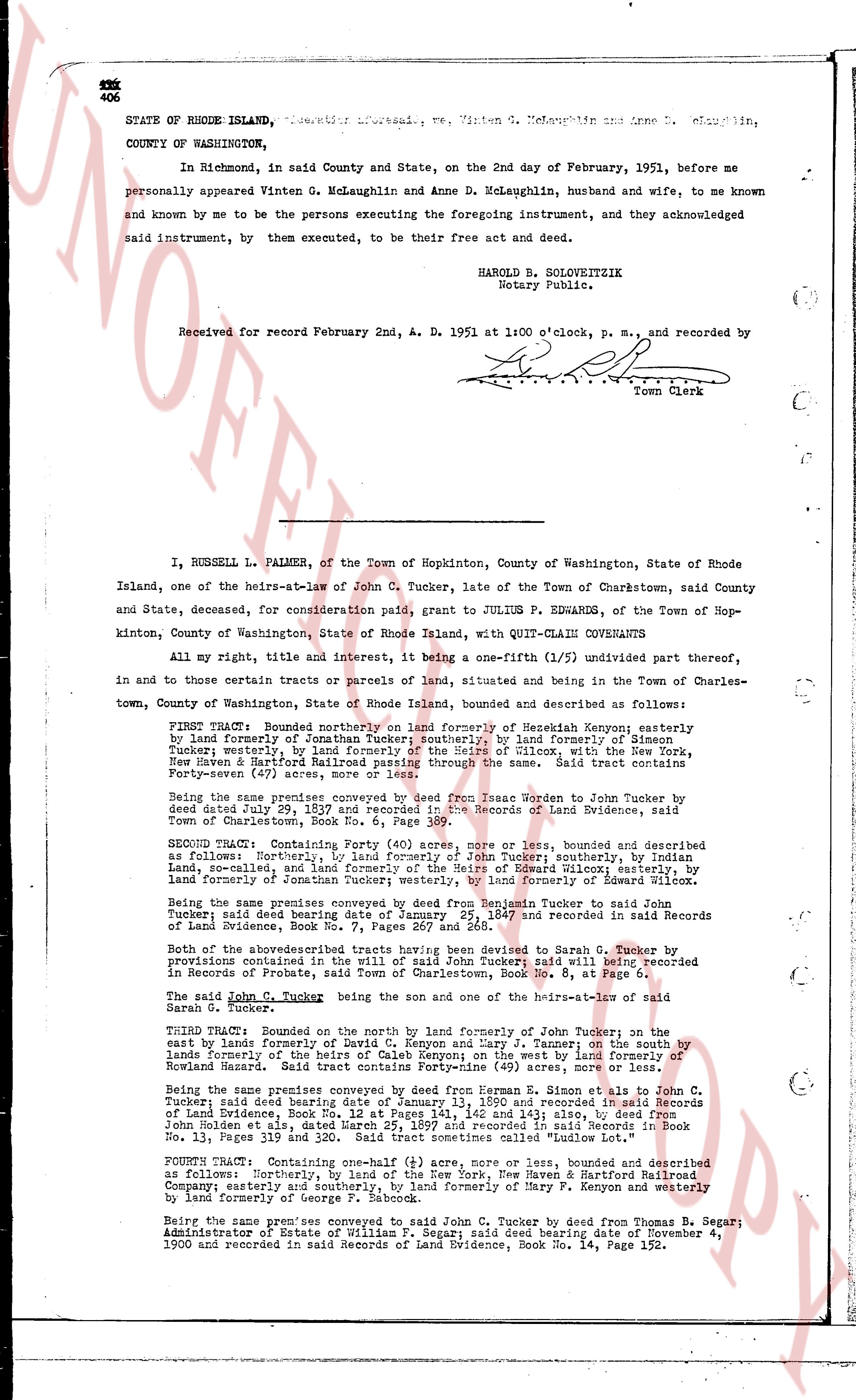
STATE OF RHODE ISLAND, ss. Before me, Vinten G. McLaughlin and Anne D. McLaughlin,
COUNTY OF WASHINGTON,
In Richmond, in said County and State, on the 2nd day of February, 1951, before me
personally appeared Vinten G. McLaughlin and Anne D. McLaughlin, husband and wife, to me known
and known by me to be the persons executing the foregoing instrument, and they acknowledged
said instrument, by them executed, to be their free act and deed.
HAROLD B. SOLOVEITZIK
Notary Public.
Received for record February 2nd, A. D. 1951 at 1:00 o'clock, p. m., and recorded by
[Signature]
Town Clerk
----
I, RUSSELL L. PALMER, of the Town of Hopkinton, County of Washington, State of Rhode
Island, one of the heirs-at-law of John C. Tucker, late of the Town of Charlestown, said County
and State, deceased, for consideration paid, grant to JULIUS F. EDWARDS, of the Town of Hop-
kinton, County of Washington, State of Rhode Island, with QUIT-CLAIM COVENANTS
All my right, title and interest, it being a one-fifth (1/5) undivided part thereof,
in and to those certain tracts or parcels of land, situated and being in the Town of Charles-
town, County of Washington, State of Rhode Island, bounded and described as follows:
FIRST TRACT: Bounded northerly on land formerly of Menekiah Kenyon; easterly
by land formerly of Jonathan Tucker; southerly; by land formerly of Simon
Tucker; westerly, by land formerly of Caleb Kenyon and Silas Tucker, with the New
Haven & Hartford Railroad passing through the same. Said tract contains
forty-seven (47) acres more or less.
Being the same premises conveyed by deed from Isaac Worden to Jonathan Tucker by
deed dated July 29, 1859 and recorded in the Records of Land Evidence, said
Town of Charlestown, Book 11, Page 111.
SECOND TRACT: Containing Forty (40) acres, more or less, bounded and described
as follows: Northerly, by land formerly of John Tucker; southerly, by land
formerly of Caleb Kenyon; easterly, by land formerly of Samuel intercourse; westerly,
by land formerly of Jonathan Tucker; westerly, by land formerly of Edward Wilcox.
Being the same premises conveyed by deed from Benjamin Tucker to said John
Tucker; said deed being dated January 25, 1847 and recorded in said Records
of Land Evidence, Book 4, Page 151.
Both of the above described tracts having been devised to Sarah C. Tucker by
provisions contained in the will of said John Tucker; said will being recorded
in Records of Probate of said Town, Probate Book No. 8, Page 112.
The said John C. Tucker being the son and one of the heirs-at-law of said
Sarah G. Tucker.
THIRD TRACT: Bounded on the north by land formerly of John Tucker; on the
east by lands formerly of David C. Kenyon and Larry J. Tanner; on the south by
lands formerly of the heirs of Caleb Kenyon on the west (40) acres, more or
less, formerly Howard Marsh. Said tract contains forty (40) acres, more or less.
Being the same premises conveyed by deed from James L. Tucker to Simon C.
Tucker; said deed being dated January 13, 1860 and recorded in said Records
of Land Evidence, Book 15, Pages 141, 142 and 143; also, by deed from
John Holden et als, dated March 25, 1881 and recorded in said Records of Land
Book No. 13, Pages 119 and 320. Said tract sometimes called "Ludlow Lot."
FOURTH TRACT: Containing one-half (1/2) acre, more or less, bounded and described
as follows: Northerly, by land formerly of New Haven & Hartford Railroad
Company; easterly and southerly, by land formerly of Mary F. Kenyon and westerly
by land formerly of George P. Babcock
Being the same premises conveyed to said John C. Tucker by deed from Thomas B. Segar;
Administrator of Estate of William P. Segar; said deed being dated November 4, 1900,
and recorded in said Records of Land Evidence, Book No. 14, Page 152.
The page as recorded