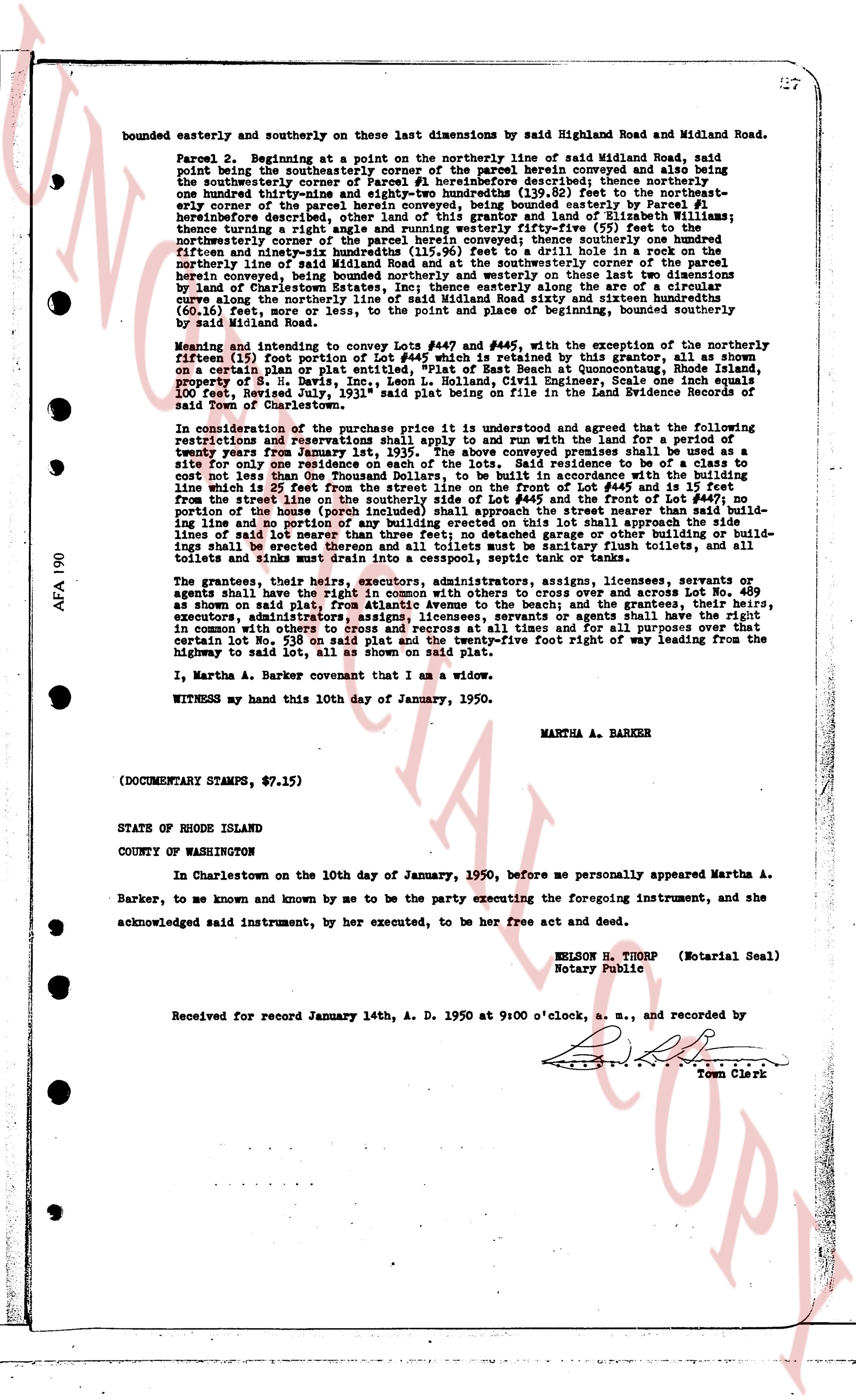
The instrument's own words
page 1 · read by Gemma vision
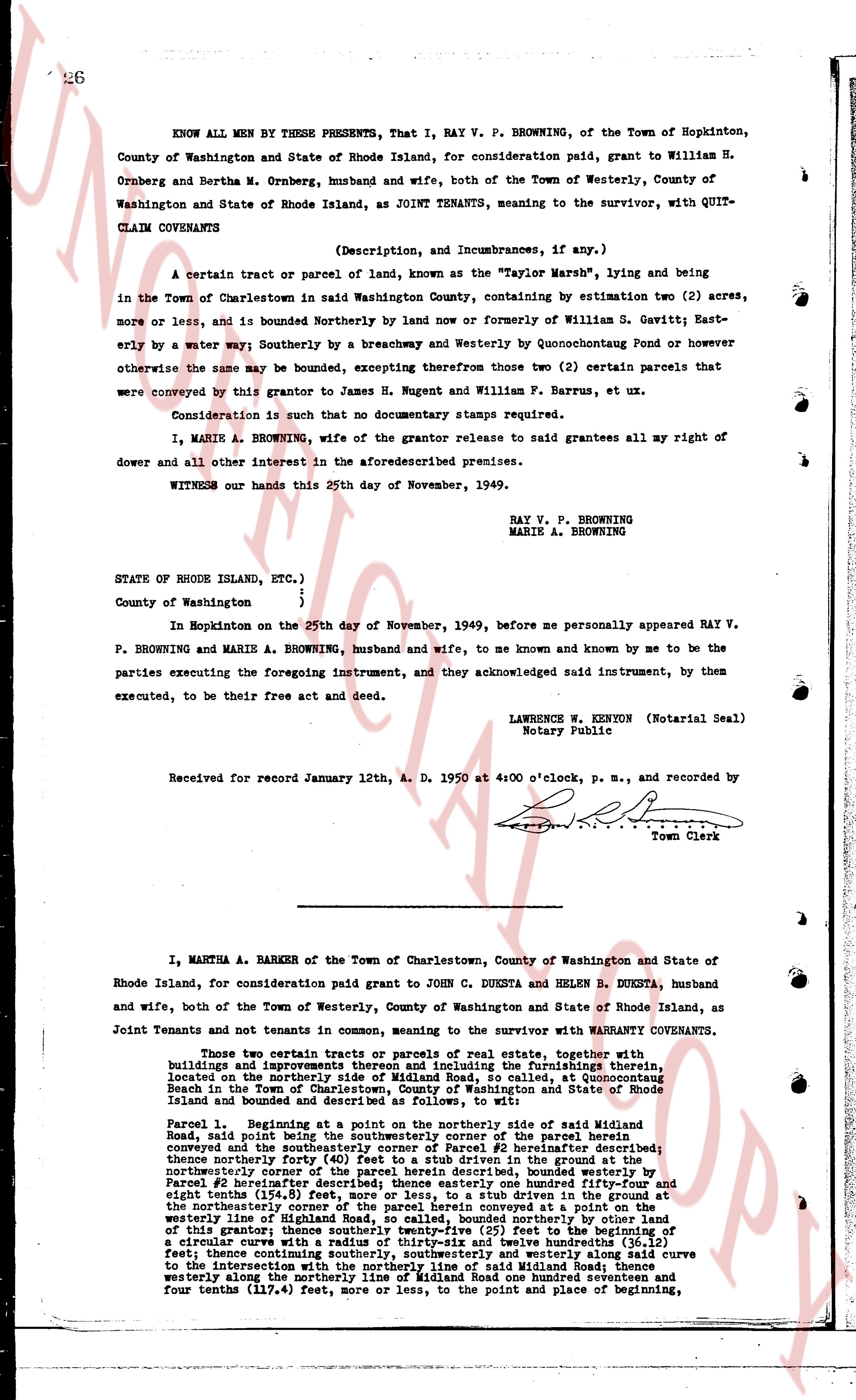
26
KNOW ALL MEN BY THESE PRESENTS, That I, RAY V. P. BROWNING, of the Town of Hopkinton, County of Washington and State of Rhode Island, for consideration paid, grant to William H. Ornberg and Bertha M. Ornberg, husband and wife, both of the Town of Westerly, County of Washington and State of Rhode Island, as JOINT TENANTS, meaning to the survivor, with QUITCLAIM COVENANTS
(Description, and Incumbrances, if any.)
A certain tract or parcel of land, known as the "Taylor Marsh", lying and being in the Town of Charlestown in said Washington County, containing by estimation two (2) acres, more or less, and is bounded Northerly by land now or formerly of William S. Gavitt; Easterly by a water way; Southerly by a breachway and Westerly by Quonochontaug Pond or however otherwise the same may be bounded, excepting therefrom those two (2) certain parcels that were conveyed by this grantor to James H. Nugent and William F. Barrus, et ux.
Consideration is such that no documentary stamps required.
I, MARIE A. BROWNING, wife of the grantor release to said grantees all my right of dower and all other interest in the aforesaidescribed premises.
WITNESS our hands this 25th day of November, 1949.
RAY V. P. BROWNING
MARIE A. BROWNING
STATE OF RHODE ISLAND, ETC.)
County of Washington }
}
In Hopkinton on the 25th day of November, 1949, before me personally appeared RAY V. P. BROWNING and MARIE A. BROWNING, husband and wife, to me and known and known by me to be the parties executing the foregoing instrument, and they acknowledged said instrument, by them executed, to be their free act and deed.
LAWRENCE W. KERTON (Notarial Seal)
Notary Public
Received for record January 12th, A. D. 1950 at 4:00 o'clock, p. m., and recorded by
[Signature]
Town Clerk
----
I, MARTHA A. BARBER of the Town of Charlestown, County of Washington and State of Rhode Island, for consideration paid grant to JOHN C. DUKESTA and HELEN B. DUKESTA, husband and wife, both of the Town of Westerly, County of Washington and State of Rhode Island, as Joint Tenants and not tenants in common, meaning to the survivor with WARRANTY COVENANTS.
Those two certain tracts or parcels of real estate, together with buildings and improvements thereon and appurtenances belonging, the premises thereafter, located on the northerly side of Midland Road, so called, at Quonochontaug Beach in the Town of Charlestown, County of Washington and State of Rhode Island based and bounded as describes as follows, to wit:
Parcel 1. Beginning at a point on the northerly side of said Midland Road said road being the boundary line between the interior of the parcel herein conveyed and the southerly corner of Parcel #2 hereinafter described; thence northerly forty (40) feet to a stub driven in the ground at the northeasterly corner of the parcel herein conveyed, bounded westerly by the stub of Parcel #2 hereinafter described; thence easterly one hundred ninety five and eight tenths (195.8) feet to a stub driven in the ground at the northeasterly corner of the parcel herein conveyed at a point on the westerly line of Diggins's land, bounded northerly by said stub and the boundary of this grantor; thence southerly twenty-five (25) feet to the beginning of a circular curve with a radius of one hundred twelve hundredths (112.00) feet; thence continuing southerly, southeasterly and westerly along said curve to the intersection of said curve and said Midland Road; thence westerly along the northerly line of Midland Road one hundred seventeen and four tenths (117.4) feet, more or less, to the point and place of beginning,
page 2 · read by Gemma vision
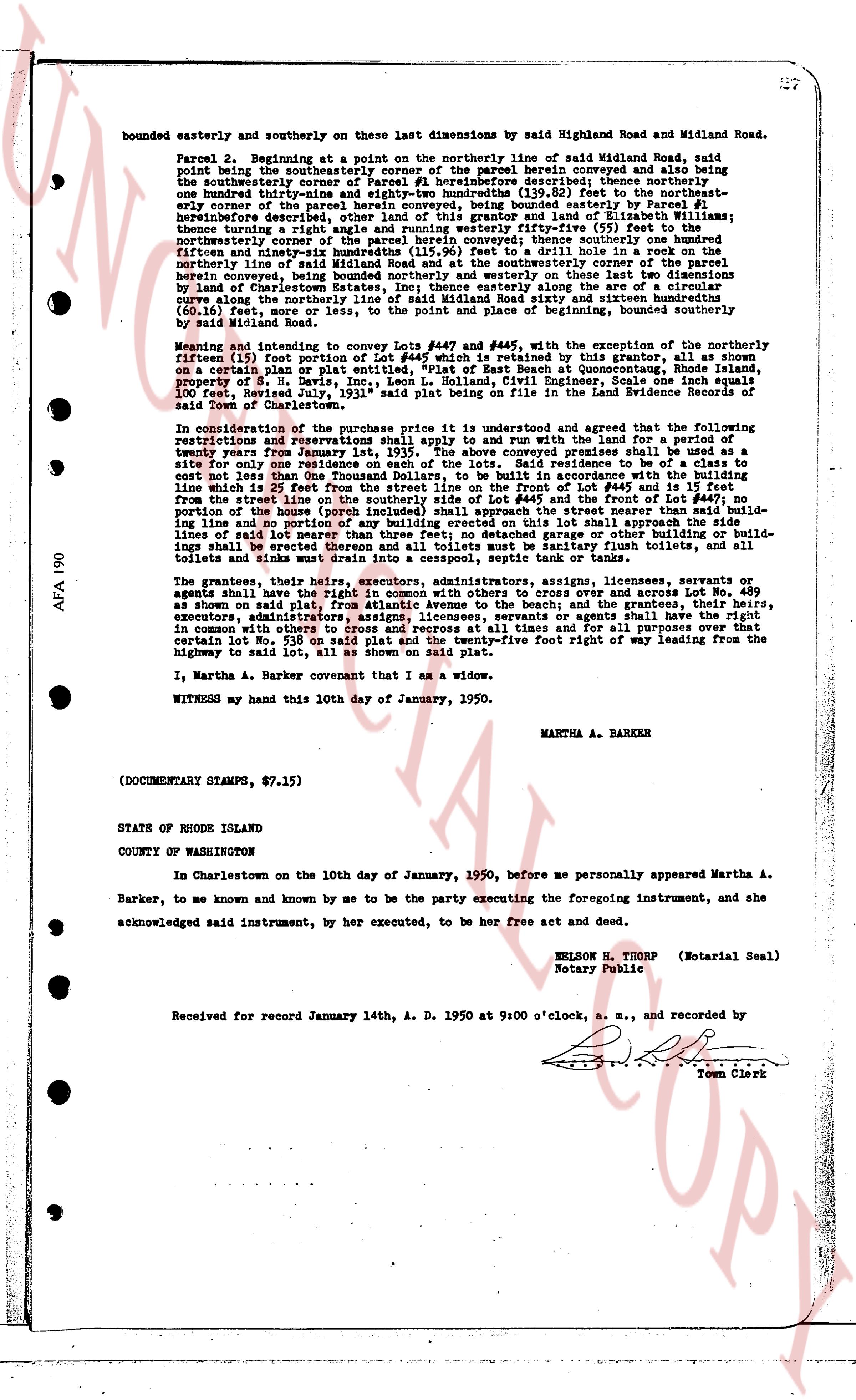
bounded easterly and southerly on these last dimensions by said Highland Road and Midland Road.
Parcel 2. Beginning at a point on the northerly line of said Midland Road, said
point being the southeasterly corner of the parcel herein conveyed and also being
the southwesterly corner of other land of the grantor, thence easterly, thence one
hundred thirty-eight and eighty-two hundredths (138.82) feet to the northeast-
erly corner of the parcel herein conveyed, being bounded westerly materially by Parcel #1
herein described, thence northerly, bounded easterly by other land of the grantor,
thence turning a right angle and running westerly fifty-five (55) feet to the
northeasterly corner of the parcel herein conveyed, being bounded northerly by dimensions
fifty-seven and ninety-five hundredths (57.95) feet and westerly on these two dimensions
fifty-seven and ninety-five hundredths (115.95) feet to a drill hole in a rock on the
northerly line of said Midland Road, said point being the northwesterly corner of the parcel
herein conveyed, being bounded northerly and westerly on these last two dimensions
by land of the grantor, thence southerly, bounded easterly by the curve along the
curve along the northerly line of said Midland Road sixty and sixteen hundredths
(60.16) feet, or a curve as set, to the point and place of beginning, bounded southerly
by said Midland Road.
Meaning and intending to convey Lot #447 and #448 in the subdivision of the northeasterly
portion of Lot #153 for port purposes as outlined in this grant, as shown on
a certain plan or plat entered on "Plat of East Beach at Quonsetpoint, Rhode Island,
property of S. B. Davis, Inc., Leon L. Holland, S.L. Civil Engineer, scale one inch equals
100 feet, Sheet 1" filed with the Town of Charlestown in the Land Evidence Records of
said Town of Charlestown.
In consideration of the purchase price it is understood and agreed that the full payment of
registrations and reservations shall apply to and run with the land and for a period of
twenty years from January 1st, 1935. The above conveyed premises shall be used as a
site for one one-family residence and shall be used for no other purpose, nor shall a house be
cost not less than One Thousand Dollars, to be built in accordance with the building
line which is 25 feet from the northerly line of Lot #447 and from the northerly line of
from the street line on the southerly side of Lot #445 and the front of Lot #447, no
portion of the home (including porches, garages, etc.) shall be built across the build-
ing line and no portion of any building erected on this lot shall approach the side
lines of said lot nearer than 10 feet, no fence or wall of any kind whatsoever shall be erec-
tions shall be erected thereon and all toilets must be sanitary flush toilets, and all
toilets and sinks must drain into a cesspool, septic tank or tank or line.
The grantors, their heirs, executors, administrators, assigns, licensees, servants or
agents shall have a right of way 10 feet wide, open and across Lot No. 489
as shown on said plat, from Atlantic Avenue to the beach; and the grantees, their heirs,
executors, administrators, assigns, licensees, servants or agents shall have a right of way
in common with others to cross and recross at all times and for all purposes over that
certain Lot No. 539 on said plat, in a strip twelve and one five foot right of way leading from the
highway to said lot, all as shown on said plat.
I, Martha A. Barker covenant that I am a widow.
WITNESS my hand this 10th day of January, 1950.
MARTHA A. BARKER
(DOCUMENTARY STAMPS, $7.15)
STATE OF RHODE ISLAND
COUNTY OF WASHINGTON
In Charlestown on the 10th day of January, 1950, before me personally appeared Martha A.
Barker, to me known and by me known and by me to be the party executing the foregoing instrument, and she
acknowledged said instrument, by her execution, to be her free act and deed.
NELSON H. THORP (Motarial Seal)
Notary Public
Received for record January 14th, A. D. 1950 at 9:00 o'clock, a. m., and recorded by
Town Clerk
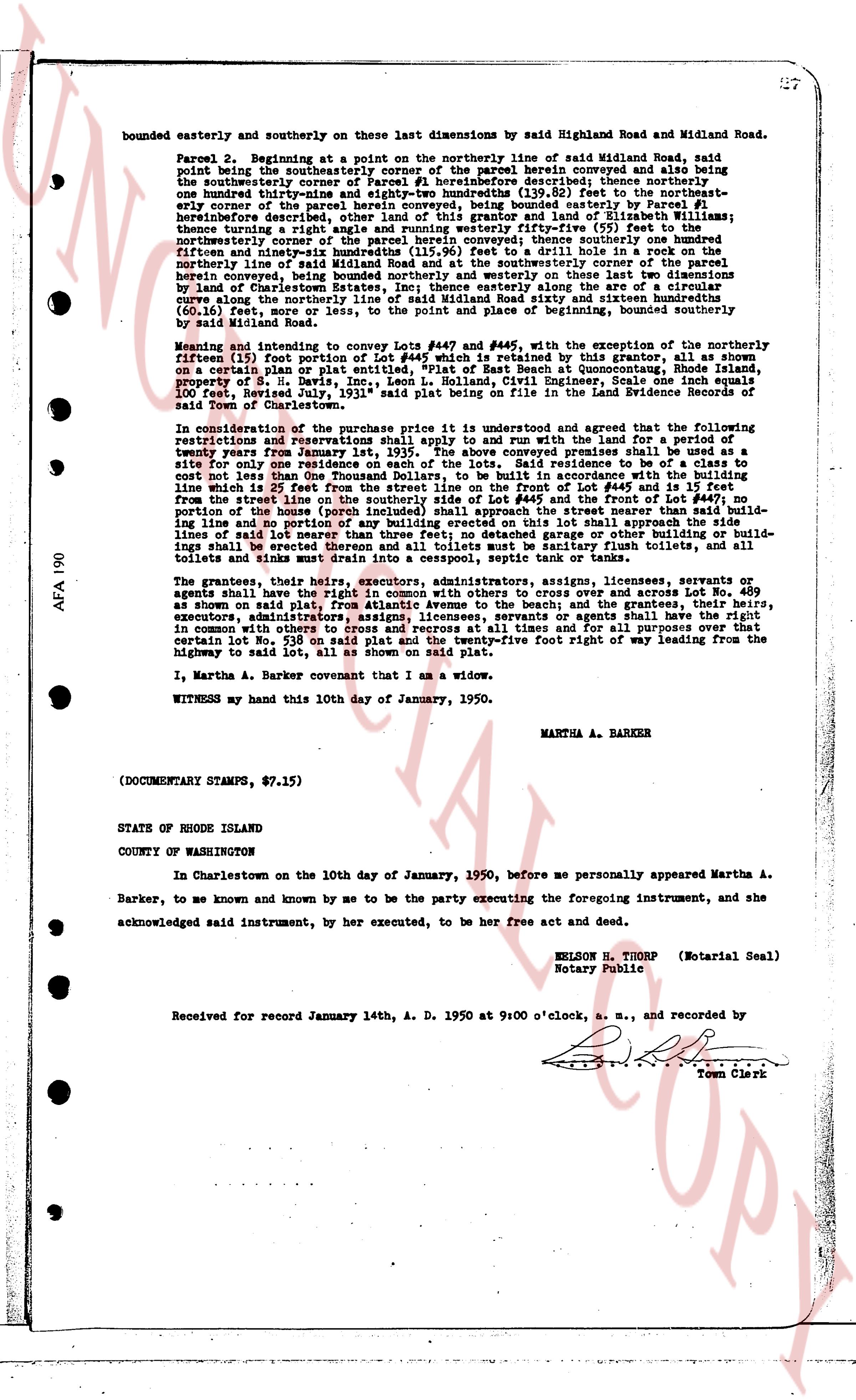
page 3 · read by Gemma vision
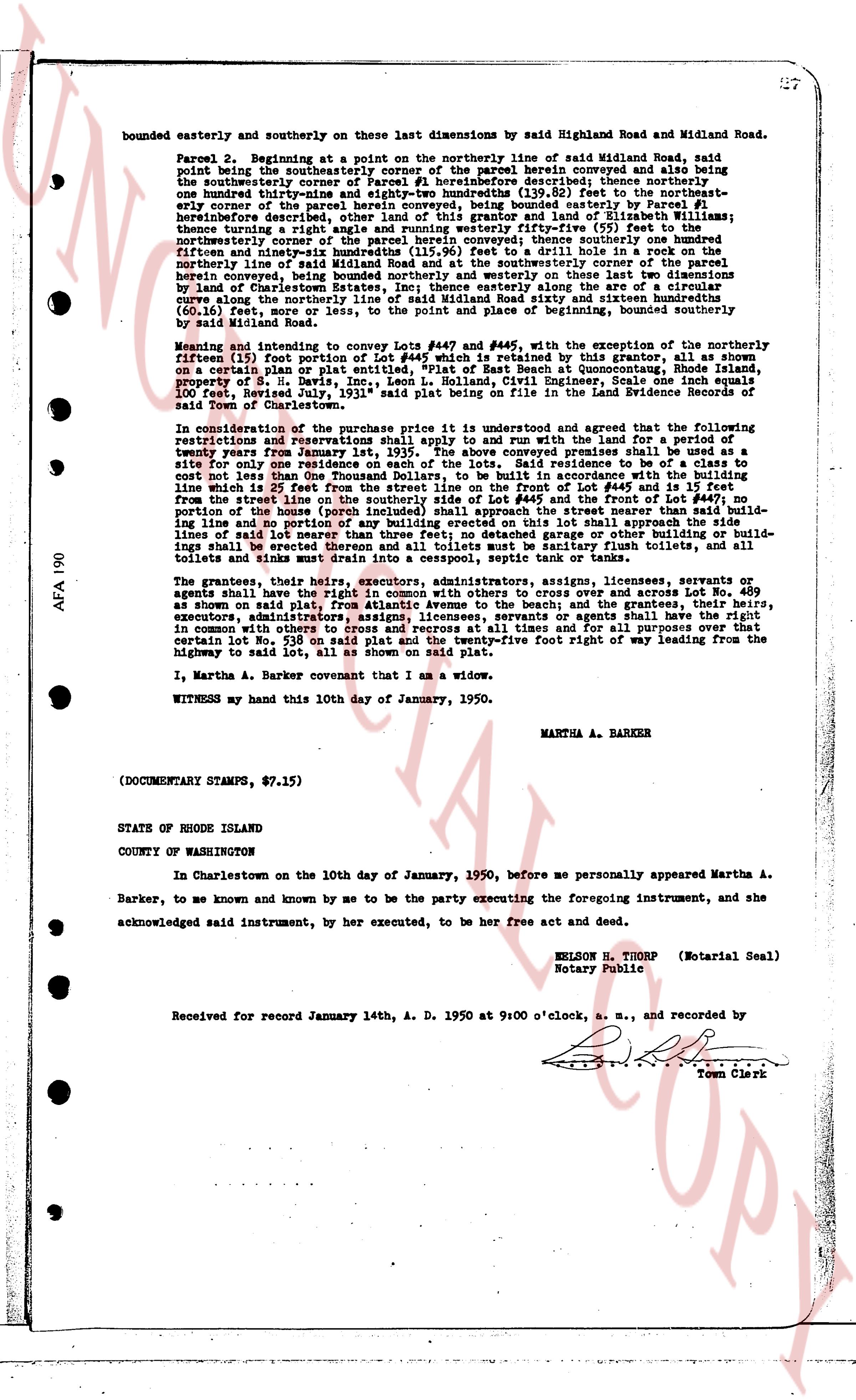
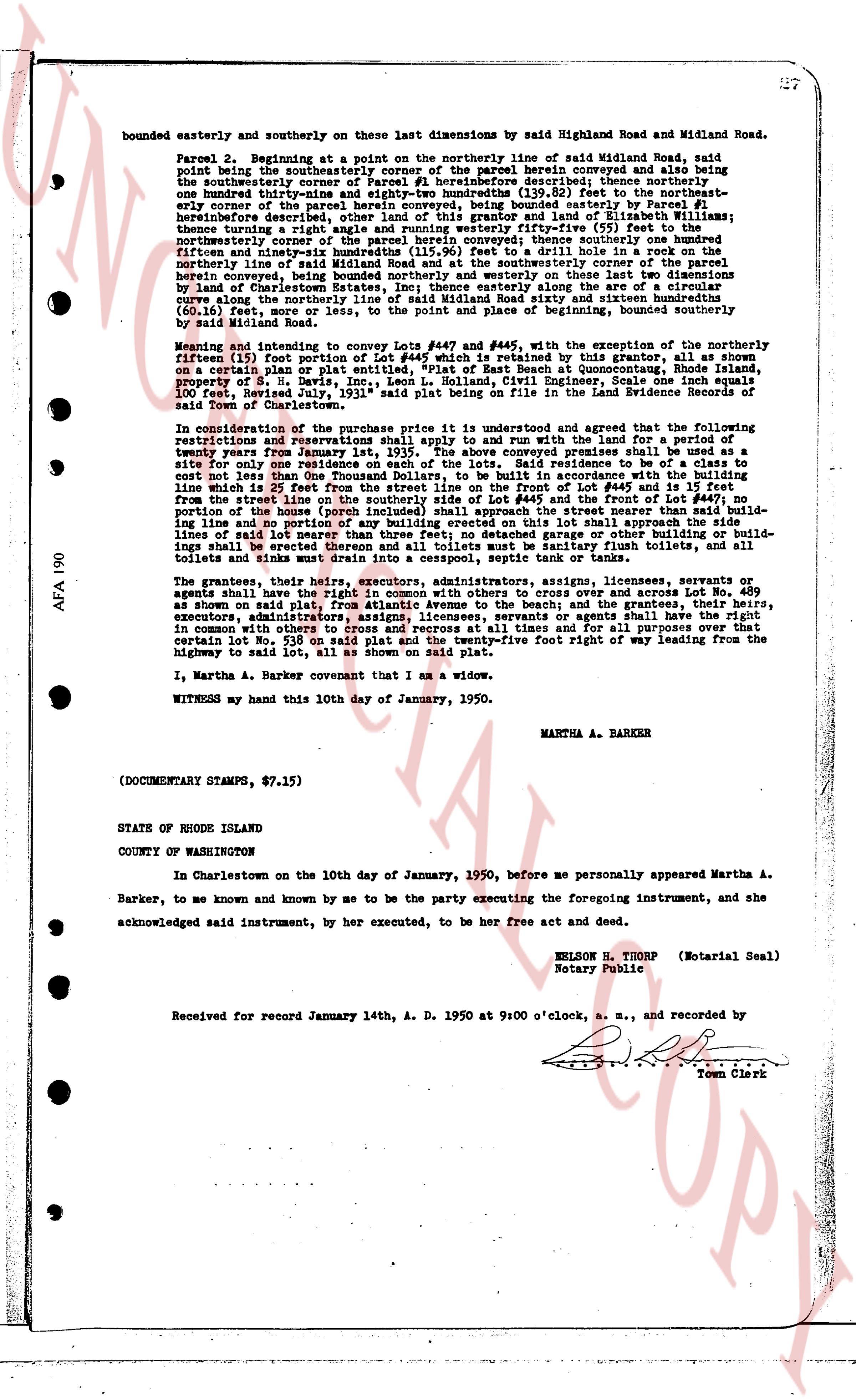
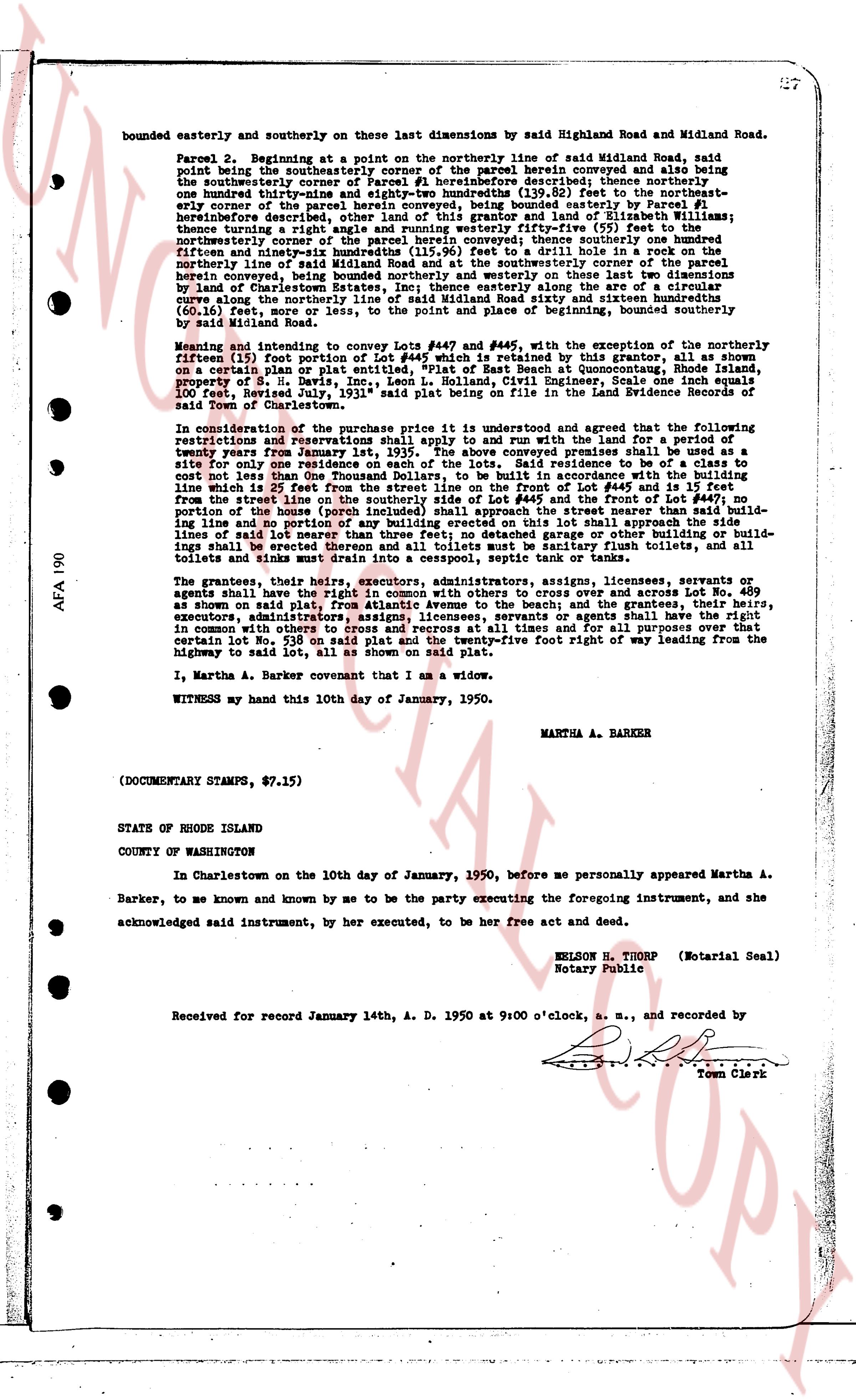
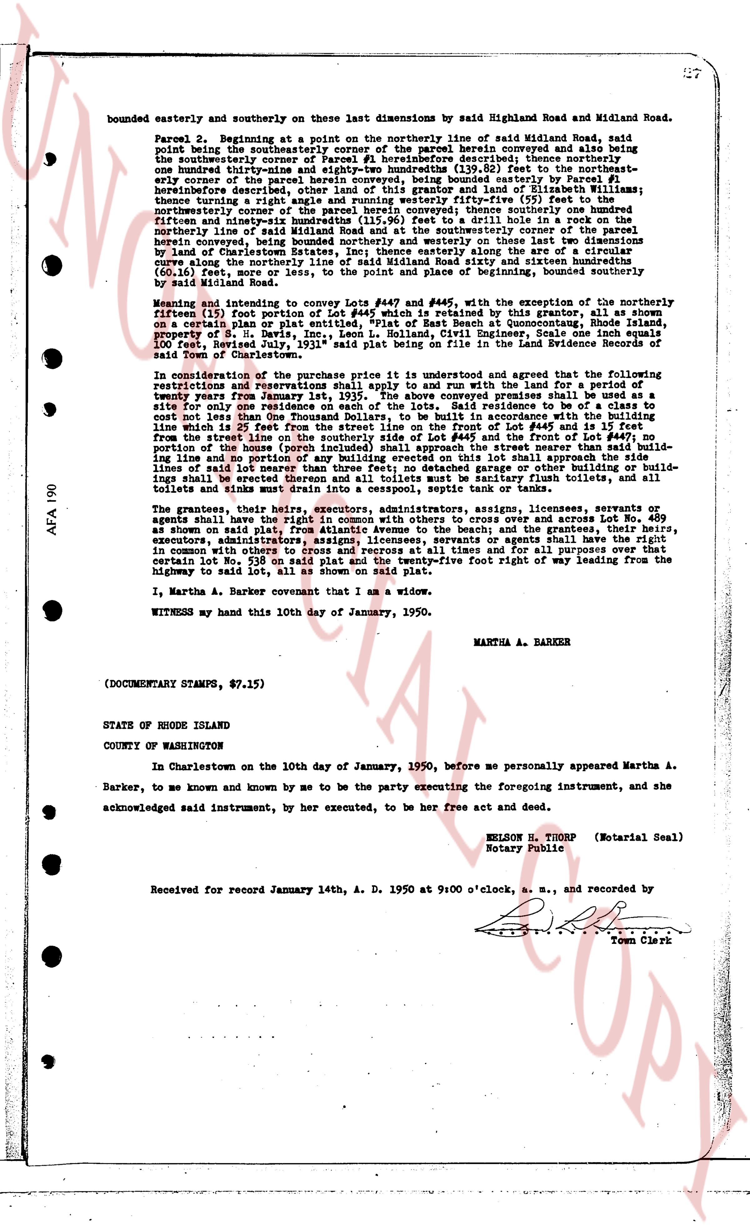
bounded easterly and southerly on these last dimensions by said Highland Road and Midland Road.
Parcel 2. Beginning at the point on the northerly line of said Midland Road, said point being the southeasterly corner of the parcel herein conveyed and also being said southeasterly corner of the other parcel herein conveyed, thence southeasterly one hundred thirty-nine and eighty-two hundredths (139.82) feet to the northeasterly corner of the parcel herein conveyed, being bounded easterly materially Parcel #1 herein described and bounded northerly by the land of [?] and land of [?] dimensions; thence turning a right angle and running westerly fifty-five (55) feet to the northeasterly corner of the other parcel herein conveyed, being bounded northerly by dimensions fifty-seven and ninety-five hundredths (57.95) feet and westerly on these last two dimensions (115.96) feet to a drill hole in a rock on the northerly line of said Midland Road, said point being the northeasterly corner of the other parcel herein conveyed, being bounded northerly and westerly on these last two dimensions by land of the [?] and southerly by said Midland Road, thence along the curve along the northerly line of said Midland Road sixty and sixteen hundredths (60.16) feet, or curve as set, to the point and place of beginning, bounded southerly by said Midland Road.
Meaning and intending to convey Lot #447 and #448 in the subdivision of the northeasterly portion [?] for porton of Lot #447 as written in this grant and as shown on a certain plan or plat entered, "Plat of East Beach at Quonsetpoint, Rhode Island, property of S. B. Davis, Inc., Leon L. Holland, S.L. Civil Engineer, scale one inch equals 100 feet, Sheet B", filed July 12, 1948, in the Land Evidence Records of the town of Charlestown.
In consideration of the purchase price it is understood and agreed that the following restrictions and reservations shall apply to and run with the land and for a period of twenty-one years from January 1st, 1935. The above conveyed premises shall be used as a site for one one-family residence of the first class or as a site for one guest house of the first class or as a site for one residence to me or a class to cost not less than One Thousand Dollars, to be built in accordance with the building line which shall be 25 feet from the northerly line of Lot #447 and the northerly line of Lot #448 from the street line on the southerly side of Lot #445 and the front of Lot #447, no portion of the home (except the front steps and porch) shall be built within the building line and no portion of any building erected on this lot shall approach the side lines of said lot nearer than 10 feet from the side lines of said lot, no fences or buildings shall be erected thereon and all toilets must be sanitary flush toilets, and all toilets and sinks must drain into a cesspool, septic tank or tank of similar kind.
The grantors, their heirs, executors, administrators, assigns, licensees, servants or agents shall have a right of way 10 feet wide, in common with others and across Lot No. 489 as shown on said plat, from Atlantic Avenue to the beach; and the grantees, their heirs, executors, administrators, assigns, licensees, servants or agents shall have a right of way in common with others to cross and recross at all times and for all purposes over that certain Lot No. 339 on said plat, in a strip twelve feet wide five foot right of way leading from the highway to said lot, all as shown on said plat.
I, Martha A. Barker covenant that I am a widow.
WITNESS my hand this 10th day of January, 1950.
MARTHA A. BARKER
(DOCUMENTARY STAMPS, $7.15)
STATE OF RHODE ISLAND
COUNTY OF WASHINGTON
In Charlestown on the 10th day of January, 1950, before me personally appeared Martha A. Barker, to me known and by me to be the party executing the foregoing instrument, and she acknowledged said instrument, by her execution, to be her free act and deed.
NELSON H. THORP (Motarial Seal)
Notary Public
Received for record January 14th, A. D. 1950 at 9:00 o'clock, a. m., and recorded by
Town Clerk
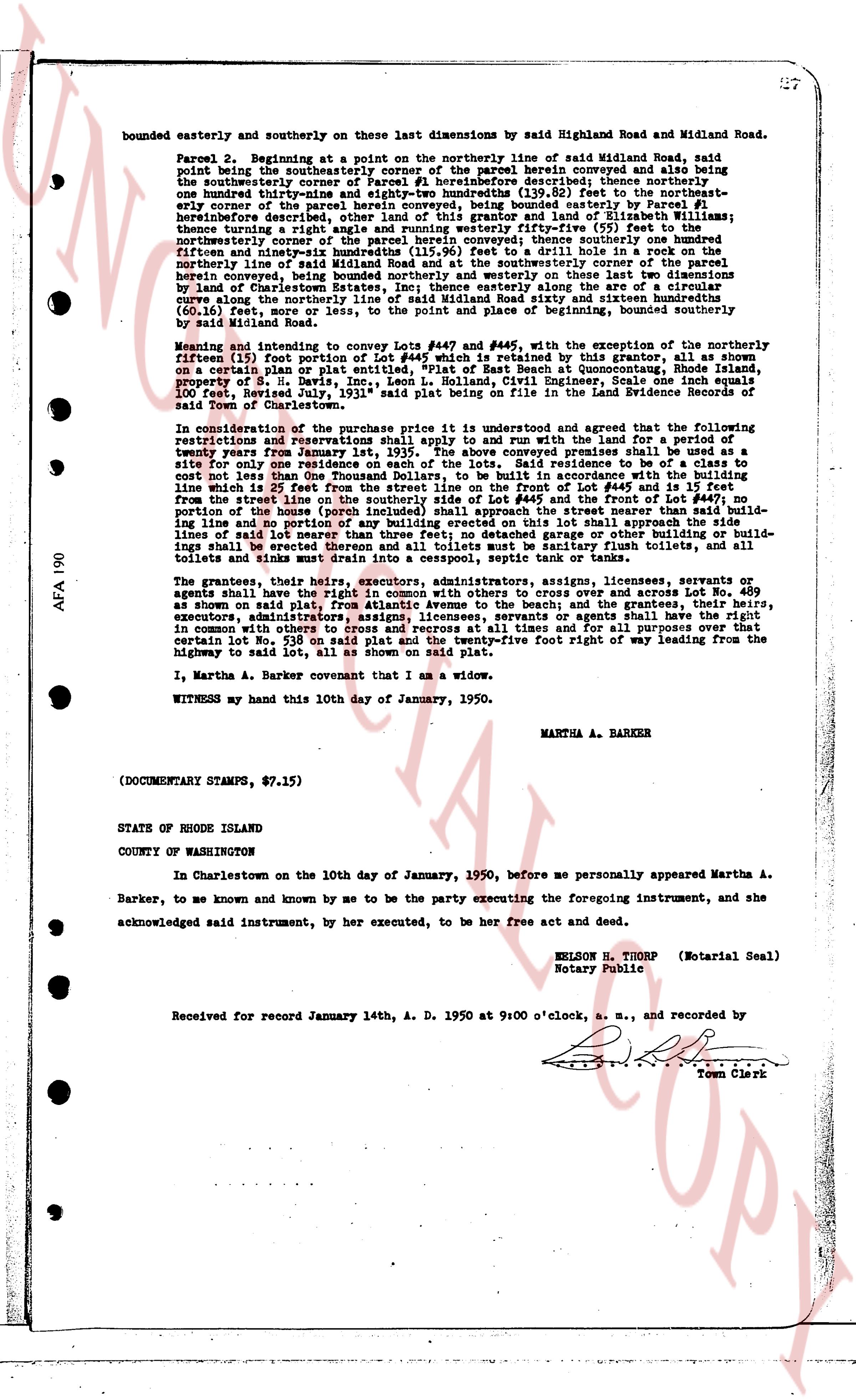
page 4 · read by Gemma vision
bounded easterly and southerly on these last dimensions by said Highland Road and Midland Road.
Parcel 2. Beginning at a point on the northerly line of said Midland Road, said point being the southeasterly corner of the parcel herein conveyed and also being said southeasterly corner of the other parcel herein conveyed, thence southeasterly, thence one hundred thirty-nine and eighty-two hundredths (139.82) feet to the northeasterly corner of the parcel herein conveyed, being bounded westerly materially by Parcel #1 herein described, thence northerly, bounded easterly by the land of [?] [?] [?], thence turning a right angle and running westerly fifty-five (55) feet to the northeasterly corner of the other parcel herein conveyed, being bounded westerly on these dimensions fifty-seven and ninety-five hundredths (57.95) feet to a drill hole in a rock on the northerly line of said Midland Road, thence southeasterly to the southeasterly corner of the parcel herein conveyed, being bounded northerly and westerly on these last two dimensions by land of the [?] [?] [?] [?], thence southerly along the curve along the northerly line of said Midland Road sixty and sixteen hundredths (60.16) feet, or vice versa, to the point and place of beginning, bounded southerly by said Midland Road.
Meaning and intending to convey Lot #447 and #448 in the subdivision of the northeasterly portion [?] for portions of Lot #447 and #448 entitled to this grant as shown on a certain plan or plat entered, "Plat of East Beach at Quonsetpoint, Rhode Island, property of S. B. Davis, Inc., Leon L. Holland, S.L. Civil Engineer, scale one inch equals 100 feet, Sheet 1", filed with the Recorder of Land Evidence in the Land Evidence Records of said Town of Charlestown.
In consideration of the purchase price it is understood and agreed that the full payment of registrations and reservations shall apply to and run with the land and for a period of twenty-one years from January 1st, 1935. The above conveyed premises shall be used as a site for one one-family residence of not more than two stories in height, of a class or cost not less than One Thousand Dollars, to be built in accordance with the building line which shall be 25 feet from the northerly line of Lot #447 and 25 feet from the building line from the street line on the southerly side of Lot #445 and the front of Lot #447, no portion of the home (including porches, garages, etc.) shall be built across the said building line and no portion of any building erected on this lot shall approach the side building lines of said lot nearer than 10 feet, no fence, wall or other structure shall be erected thereon and all toilets must be sanitary flush toilets, and all toilets and sinks must drain into a cesspool, septic tank or land of drainage.
The grantors, their heirs, executors, administrators, assigns, licensees, servants or agents shall have a right of way 10 feet wide, in common with others and across Lot No. 489 as shown on said plat, from Atlantic Avenue to the beach; and the grantees, their heirs, executors, administrators, assigns, licensees, servants or agents shall have a right of way in common with others to cross and recross at all times and for all purposes over that certain Lot No. 539 on said plat, in a ten foot wide prescriptive foot right of way leading from the highway to said lot, all as shown on said plat.
I, Martha A. Barker covenant that I am a widow.
WITNESS my hand this 10th day of January, 1950.
MARTHA A. BARKER
(DOCUMENTARY STAMPS, $7.15)
STATE OF RHODE ISLAND
COUNTY OF WASHINGTON
In Charlestown on the 10th day of January, 1950, before me personally appeared Martha A. Barker, to me known and by me to be the party executing the foregoing instrument, and she acknowledged said instrument, by her execution, to be her free act and deed.
NELSON H. THORP (Notarial Seal)
Notary Public
Received for record January 14th, A. D. 1950 at 9:00 o'clock, a. m., and recorded by
Town Clerk
page 5 · read by Gemma vision
bounded easterly and southerly on these last dimensions by said Highland Road and Midland Road.
Parcel 2. Beginning at the point on the northerly line of said Midland Road, said point being the southeasterly corner of the parcel herein conveyed and also being said southeasterly corner of the other parcel herein conveyed, thence southeasterly, thence one hundred thirty-nine and eighty-two hundredths (139.82) feet to the northeasterly corner of the parcel herein conveyed, being bounded westerly materially by Parcel #1 herein described, thence northerly, bounded easterly by the land of [?] [?] [?], thence turning a right angle and running westerly fifty-five (55) feet to the northeasterly corner of the other parcel herein conveyed, being bounded easterly on two dimensions fifty-seven and ninety-five hundredths (57.95) feet and one hundred fifteen and ninety-five hundredths (115.95) feet to a drill hole in a rock on the northerly line of said Midland Road, thence southwesterly corner of the other parcel herein conveyed, being bounded northerly and westerly on these last two dimensions by land of the [?] [?] [?] [?], thence southerly along the curve along the northerly line of said Midland Road sixty and sixteen hundredths (60.16) feet, or curve as set, to the point and place of beginning, bounded southerly by said Midland Road.
Meaning and intending to convey Lot #447 and #448 in the subdivision of the northeasterly portion [?] for portions of Lot #447 and #448 referred to in this grant, as shown on a certain plan or plat entered on "Plat of East Beach at Quonsetpoint, Rhode Island, property of S. B. Davis, Inc., Leon L. Holland, S.L. Civil Engineer, scale one inch equals 100 feet, Sheet B", filed with the land evidence records in the Land Evidence Records of the town of Charlestown.
In consideration of the purchase price it is understood and agreed that the full period of registrations and reservations shall apply to and run with the land and for a period of twenty-one years from January 1st, 1935. The above conveyed premises shall be used as a site for one one-family residence of not more than 1 1/2 stories in height and of a cost not less than One Thousand Dollars, to be built in accordance with the building line which shall be 25 feet from the northerly line of Lot #447 and 25 feet from the building line from the street line on the southerly side of Lot #445 and the front of Lot #447, no portion of the home (except for steps, porches, etc.) shall be built across the building line and no portion of any building erected on this lot shall approach the side building line of said lot nearer than 10 feet, no fence, wall or other structure shall be erected thereon and all toilets must be sanitary flush toilets, and all toilets and sinks must drain into a cesspool, septic tank or land of drainage.
The grantors, their heirs, executors, administrators, assigns, licensees, servants or agents agree that the public shall have a right of way over and across Lot No. 489 as shown on said plat, from Atlantic Avenue to the beach; and the grantees, their heirs, executors, administrators, assigns, licensees, servants or agents agree that they shall have in common with others to cross and recross at all times and for all purposes over that certain Lot No. 339 on said plat, along a twelve foot right of way leading from the highway to said lot, all as shown on said plat.
I, Martha A. Barker covenant that I am a widow.
WITNESS my hand this 10th day of January, 1950.
MARTHA A. BARKER
(DOCUMENTARY STAMPS, $7.15)
STATE OF RHODE ISLAND
COUNTY OF WASHINGTON
In Charlestown on the 10th day of January, 1950, before me personally appeared Martha A. Barker, to me known and by me to be the party executing the foreground instrument, and she acknowledged said instrument, by her execution, to be her free act and deed.
NELSON H. THORP (Motarial Seal)
Notary Public
Received for record January 14th, A. D. 1950 at 9:00 o'clock, a. m., and recorded by
Town Clerk
page 6 · read by Gemma vision
bounded easterly and southerly on these last dimensions by said Highland Road and Midland Road.
Parcel 2. Beginning at a point on the northerly line of said Midland Road, said point being the southeasterly corner of the parcel herein conveyed and also being said southeasterly corner of the other parcel herein conveyed, thence southeasterly thence one hundred thirty-nine and eighty-two hundredths (139.82) feet to the northeasterly corner of the parcel herein conveyed, being bounded westerly materially by Parcel #1 herein described, thence northerly one hundred thirty-nine and eighty-two hundredths (139.82) feet, thence turning a right angle and running westerly fifty-five (55) feet to the northeasterly corner of the other parcel herein conveyed, and bounded easterly on these last dimensions by fifty-nine and ninety-six hundredths (115.96) feet to a drill hole in a rock on the northerly line of said Midland Road, thence northerly one hundred thirty-nine and eighty-two hundredths (139.82) feet to the northeasterly corner of the other parcel herein conveyed, being bounded northerly and westerly on these last two dimensions by land of the Trustees of the Rhode Island School of Economics, thence along the curve along the northerly line of said Midland Road sixty and sixteen hundredths (60.16) feet, or curve as to, the point and place of beginning, bounded southerly by said Midland Road.
Meaning and intending to convey Lot #447 and #448 in the subdivision of the northeasterly portion of Lot #153 for porch lots in the subdivision entitled "The Pines" as shown on a certain plan or plat entered on "Plat Book of East Quonsetown, Rhode Island, property of S. B. Davis, Inc., Leon L. Holland, S.L. Engineer, Scale one inch equals 100 feet, Sheet Bipley July 1936" recorded in the Land Evidence Records of the town of Charlestown.
In consideration of the purchase price it is understood and agreed that the full period of registrations and reservations shall apply to and run with the land and for a period of twenty-one years from January 1st, 1935. The above conveyed premises shall be used as a site for one one-family residence of not more than two stories in height, of a class or cost not less than One Thousand Dollars, to be built in accordance with the building line which shall be 25 feet from the northerly line of Lot #447 and 25 feet from the building line from the street line on the southerly side of Lot #445 and the front of Lot #447, no portion of the home (including porches) shall be built within 25 feet of the side building line and no portion of any building erected on this lot shall approach the side building line of said lot nearer than 10 feet, no fence or wall of any kind whatsoever shall be erected thereon and all toilets must be sanitary flush toilets, and all toilets and sinks must drain into a cesspool, septic tank or land of drainage.
The grantors, their heirs, executors, administrators, assigns, licensees, servants or agents agree that the grantee, their heirs, executors, administrators, assigns, licensees, servants in common with others to cross and recross at all times and for all purposes over and across Lot No. 489 as shown on said plat, from Atlantic Avenue to the beach; and the grantees, their heirs, executors, administrators, assigns, licensees, servants in common with others to cross and recross in common with others to cross and recross at all times and for all purposes over that certain Lot No. 539 on said plat, in a strip twelve feet wide and twelve feet right of way leading from the highway to said lot, all as shown on said plat.
I, Martha A. Barker covenant that I am a widow.
WITNESS my hand this 10th day of January, 1950.
MARTHA A. BARKER
(DOCUMENTARY STAMPS, $7.15)
STATE OF RHODE ISLAND
COUNTY OF WASHINGTON
In Charlestown on the 10th day of January, 1950, before me personally appeared Martha A. Barker, to me known and by me to be the party executing the foregoing instrument, and she acknowledged said instrument, by her execution, to be her free act and deed.
NELSON H. THORP (Motarial Seal)
Notary Public
Received for record January 14th, A. D. 1950 at 9:00 o'clock, a. m., and recorded by
Town Clerk
page 7 · read by Gemma vision
bounded easterly and southerly on these last dimensions by said Highland Road and Midland Road.
Parcel 2. Beginning at the point on the northerly line of said Midland Road, said point being the southeasterly corner of the parcel herein conveyed and also being said southeasterly corner of the other parcel herein conveyed and also being said southwesterly corner of the other parcel herein conveyed and measuring thence northeasterly one hundred thirty-nine and eighty-two hundredths (139.82) feet to the northeasterly corner of the parcel herein conveyed, being bounded westerly materially by Parcel #1 herein described and by the land of [?] [?] and land of [?] [?] and measuring thence turning a right angle and running westerly fifty-five (55) feet to the northeasterly corner of the other parcel herein conveyed and measuring thence northwesterly five hundred ninety-three hundredths (115.96) feet to a drill hole in a rock on the northerly line of said Midland Road, said point being the northeasterly corner of the other parcel herein conveyed, being bounded northerly and westerly on these last two dimensions by land of [?] [?] and measuring thence southerly along the curve along the northerly line of said Midland Road sixty and sixteen hundredths (60.16) feet or there to, to the point and place of beginning, bounded southerly by said Midland Road.
Meaning and intending to convey Lot #447 and #448 in the subdivision of the northeasterly portion [?] for portions of Lot #447 and #448 referred to in this grant as shown on a certain plan or plat entitled, "Plat of East Beach at Quonsetpoint, Rhode Island, property of S. B. Davis, Inc., Leon L. Holland, S.L. Civil Engineer, scale one inch equals 100 feet, Sheet B" filed with the land evidence records in the Land Evidence Books of the town of Charlestown.
In consideration of the purchase price it is understood and agreed that the following restrictions and reservations shall apply to and run with the land and for a period of twenty-one years from January 1st, 1935. The above conveyed premises shall be used as a site for and for one residence only to be used as a private residence to me or to a class of not cost less than One Thousand Dollars, to be built in accordance with the building line which shall be 25 feet from the northerly line of Lot #447 and 25 feet from the building line from the street line on the southerly side of Lot #445 and the front of Lot #447, no portion of the home (except for steps, porches, etc.) shall be built across the said building line and no portion of any building erected on this lot shall approach the side lines of said lot nearer than 10 feet from the side lines of said lot, no other buildings shall be erected thereon and all toilets must be sanitary flush toilets, and all toilets and sinks must drain into a cesspool, septic tank or land of drainage.
The grantors, their heirs, executors, administrators, assigns, licensees, servants or agents waive any claim to the right of way over and across Lot No. 489 as shown on said plat, from Atlantic Avenue to the beach; and the grantees, their heirs, executors, administrators, assigns, licensees, agents shall have the right of way in common with others to cross and recross at all times and for all purposes over that certain Lot No. 489 on a strip of land twenty-five feet right of way leading from the highway to said lot, all as shown on said plat.
I, Martha A. Barker covenant that I am a widow.
WITNESS my hand this 10th day of January, 1950.
MARTHA A. BARKER
(DOCUMENTARY STAMPS, $7.15)
STATE OF RHODE ISLAND
COUNTY OF WASHINGTON
In Charlestown on the 10th day of January, 1950, before me personally appeared Martha A. Barker, to me known and by me to be the party executing the foregoing instrument, and she acknowledged said instrument, by her execution, to be her free act and deed.
NELSON H. THORP (Notarial Seal)
Notary Public
Received for record January 14th, A. D. 1950 at 9:00 o'clock, a. m., and recorded by
Town Clerk
page 8 · read by Gemma vision
bounded easterly and southerly on these last dimensions by said Highland Road and Midland Road.
Parcel 2. Beginning at a point on the northerly line of said Midland Road, said point being the southeasterly corner of the parcel herein conveyed and also being said southeasterly corner of the parcel herein conveyed, being materially bounded, thence one hundred thirty-nine and eighty-two hundredths (139.82) feet to the northeasterly corner of the parcel herein conveyed, being bounded materially Parcel #1 therefore bounded easterly on this dimension by said Parcel #1 and bounded northerly on this dimension by the land of [?] [?], thence turning a right angle and running westerly fifty-five (55) feet to the northeasterly corner of said Parcel #1, being bounded northerly on this dimension by one hundred fifty-nine and ninety-three hundredths (159.93) feet to a drill hole in a rock on the northerly line of said Midland Road, thence turning a westerly corner of the parcel herein conveyed, being bounded northerly and westerly on these last two dimensions by said Road, and thence turning a right angle and running southerly along the arc of the curve along the northerly line of said Midland Road sixty and sixteen hundredths (60.16) feet, or curve as to, the point and place of the beginning, bounded southerly by said Midland Road.
Meaning and intending to convey Lot #447 and #448 in the subdivision of the northeasterly portion [?] for porton of Lot #447 as written in this grant, as shown on a certain plan or plat entered, "Plat of East Beach at Quonsetpoint, Rhode Island, property of S. B. Davis, Inc., Leon L. Holland, S.L. Civil Engineer, scale one inch equals 100 feet, Sheet B", filed with the Town of Charlestown in the Land Evidence Books of the town of Said Town of Charlestown.
In consideration of the purchase price it is understood and agreed that the full payment of registrations and reservations shall apply to and run with the land and for a period of twenty-one years from January 1st, 1935. The above conveyed premises shall be used as a site for and as one residence only, and as a site for a private residence not to be of a class or cost not less than One Thousand Dollars, to be built in accordance with the building line which is 25 feet from the northerly line of Lot #447 and of the front of Lot #448, not from the street line on the southerly side of Lot #445 and the front of Lot #446, no portion of the home (except for steps, porches, etc.) shall be built across the building line and no portion of any building erected on this lot shall approach the side building line of said lot nearer than 10 feet, and no other building or structure of any kind shall be erected thereon and all toilets must be sanitary flush toilets, and all toilets and sinks must drain into a cesspool, septic tank or similar.
The grantors, their heirs, executors, administrators, assigns, licensees, servants or agents shall have a right of way 10 feet wide, in common over and across Lot No. 489 as shown on said plat, from Atlantic Avenue to the beach; and the grantees, their heirs, executors, administrators, assigns, licensees, servants or agents shall have a right of way in common with others to cross and recross at all times and for all purposes over that certain Lot No. 489 on a dimension of twenty-five feet right of way leading from the highway to said lot, all as shown on said plat.
I, Martha A. Barker covenant that I am a widow.
WITNESS my hand this 10th day of January, 1950.
MARTHA A. BARKER
(DOCUMENTARY STAMPS, $7.15)
STATE OF RHODE ISLAND
COUNTY OF WASHINGTON
In Charlestown on the 10th day of January, 1950, before me personally appeared Martha A. Barker, to me known and by me to be the party executing the foregoing instrument, and she acknowledged said instrument, by her execution, to be her free act and deed.
NELSON H. THORP (Motarial Seal)
Notary Public
Received for record January 14th, A. D. 1950 at 9 o'clock, a. m., and recorded by
Town Clerk
page 9 · read by Gemma vision
bounded easterly and southerly on these last dimensions by said Highland Road and Midland Road.
Parcel 2. Beginning at a point on the northerly line of said Midland Road, said point being the southeasterly corner of the parcel herein conveyed and also being the southwesterly corner of other land of the grantor, thence running easterly, one hundred thirty-eight and eighty-two hundredths (138.82) feet to the northeasterly corner of the parcel herein conveyed, being bounded westerly materially by Parcel 1 herein described and easterly by other land of the grantor and land of Industrial Trust Company, thence turning a right angle and running westerly fifty-five (55) feet to the northeasterly corner of the parcel herein conveyed, being bounded northerly and westerly on these last two dimensions by other land of the grantor, thence running southerly, one hundred fifty-seven and ninety-five hundredths (157.95) feet to a drill hole in a rock on the northerly line of said Midland Road, said point being the southwesterly corner of the parcel herein conveyed, being bounded northerly and westerly on these last two dimensions by land of the grantor, thence running easterly along the curve along the northerly line of said Midland Road sixty and sixteen hundredths (60.16) feet, or curve as to, the point and place of beginning, being bounded southerly by said Midland Road.
Meaning and intending to convey Lot #447 and #448 in the subdivision of the northeasterly portion of Lot #153 for porch lots in Charlestown, Rhode Island as shown on a certain plan or plat entitled, "Plat of East Beach at Quonsetpoint, Rhode Island, property of S. B. Davis, Inc., Leon L. Holland, S.L. Civil Engineer, scale one inch equals 100 feet, Sheet B", filed with the Registry of Land Evidence in the Land Evidence Records of the town of Charlestown.
In consideration of the purchase price it is understood and agreed that the full satisfaction of registrations and reservations shall apply to and run with the land and for a period of twenty-one years from January 1st, 1935. The above conveyed premises shall be used as a site for and for one residence only, and no other building or residence to me or to a class of cost not less than One Thousand Dollars, to be built in accordance with the building line which shall be 25 feet from the northerly line of Lot #447 and 25 feet from the building line from the street line on the southerly side of Lot #445 and the front of Lot #447, no portion of the home (including porches) shall be built within the building line, no other building line and no portion of any building erected on this lot shall approach the side lines of said lot nearer than 10 feet, no fence or other structure of any kind of buildings shall be erected thereon and all toilets must be sanitary flush toilets, and all toilets and sinks must drain into a cesspool, septic tank or land of drainage.
The grantors, their heirs, executors, administrators, assigns, licensees, servants or agents shall have a right of way 10 feet wide, in common with others and across Lot No. 489 as shown on said plat, from Atlantic Avenue to the beach; and the grantees, their heirs, executors, administrators, assigns, licensees, servants or agents shall have a right of way in common with others to cross and recross at all times and for all purposes over that certain Lot No. 539 on said plat, in a strip twelve feet wide running from the highway to said lot, all as shown on said plat.
I, Martha A. Barker covenant that I am a widow.
WITNESS my hand this 10th day of January, 1950.
MARTHA A. BARKER
(DOCUMENTARY STAMPS, $7.15)
STATE OF RHODE ISLAND
COUNTY OF WASHINGTON
In Charlestown on the 10th day of January, 1950, before me personally appeared Martha A. Barker, to me known and by me to be the party executing the foreground instrument, and she acknowledged said instrument, by her execution, to be her free act and deed.
NELSON H. THORP (Notarial Seal)
Notary Public
Received for record January 14th, A. D. 1950 at 9:00 o'clock, a. m., and recorded by
Town Clerk
AFA 190
page 10 · read by Gemma vision
bounded easterly and southerly on these last dimensions by said Highland Road and Midland Road.
Parcel 2. Beginning at a point on the northerly line of said Midland Road, said point being the southeasterly corner of the parcel herein conveyed and also being said southeasterly corner of the other parcel herein conveyed, thence southeasterly one hundred thirty-nine and eighty-two hundredths (139.82) feet to the northeasterly corner of the parcel herein conveyed, being bounded westerly materially by Parcel 1 herein described, thence northerly one hundred thirty-nine and eighty-two hundredths (139.82) feet, thence turning a right angle and running westerly fifty-five (55) feet to the northeasterly corner of the other parcel herein conveyed, being bounded westerly on dimensions fifty-seven and ninety-five hundredths (115.95) feet to a drill hole in a rock on the northerly line of said Midland Road, thence southeasterly to the southeasterly corner of the parcel herein conveyed, being bounded northerly and westerly on these last two dimensions by said land of the grantor, and finally running southeasterly along the curve along the northerly line of said Midland Road sixty and sixteen hundredths (60.16) feet, or vice versa, to the point and place of beginning, bounded southerly by said Midland Road.
Meaning and intending to convey Lot #447 and #448 in the subdivision of the northeasterly portion [?] for portions of Lot #447 and #448 referred to in this grant, as shown on a certain plan or plat entitled, "Plat of East Beach at Quonsetpoint, Rhode Island, property of S. B. Davis, Inc., Leon L. Holland, S.L. Civil Engineer, scale one inch equals 100 feet, Sheet B", filed with the Land Evidence Records in the Land Evidence Records office of Town of Charlestown.
In consideration of the purchase price it is understood and agreed that the full satisfaction of registrations and reservations shall apply to and run with the land and for a period of twenty-one years from January 1st, 1935. The above conveyed premises shall be used as a site for and for one residence only, and no other building or residence to me or a class of to cost not less than One Thousand Dollars, to be built in accordance with the building line which shall be 25 feet from the northerly line of Lot #447 and 25 feet from the building line from the street line on the southerly side of Lot #445 and the front of Lot #447, no portion of the fence (including the fence of the residence) or any other building or building line and no portion of any building erected on this lot shall approach the side lines of said land to within 15 feet, and no other building or buildings shall be erected thereon and all toilets must be sanitary flush toilets, and all toilets and sinks must drain into a cesspool, septic tank or tank of similar.
The grantors, their heirs, executors, administrators, assigns, licensees, servants or agents shall have a right of way for ingress and egress over and across Lot No. 489 as shown on said plat, from Atlantic Avenue to the beach; and the grantees, their heirs, executors, administrators, assigns, licensees, servants or agents shall have a right of way in common with others to cross and recross at all times and for all purposes over that certain Lot No. 489 on said plat, along a twelve foot right of way leading from the highway to said lot, all as shown on said plat.
I, Martha A. Barker covenant that I am a widow.
WITNESS my hand this 10th day of January, 1950.
MARTHA A. BARKER
(DOCUMENTARY STAMPS, $7.15)
STATE OF RHODE ISLAND
COUNTY OF WASHINGTON
In Charlestown on the 10th day of January, 1950, before me personally appeared Martha A. Barker, to me known and by me to be the party executing the foregoing instrument, and she acknowledged said instrument, by her execution, to be her free act and deed.
NELSON H. THORP (Notarial Seal)
Notary Public
Received for record January 14th, A. D. 1950 at 9:00 o'clock, a. m., and recorded by
Town Clerk
page 11 · read by Gemma vision
bounded easterly and southerly on these last dimensions by said Highland Road and Midland Road.
Parcel 2. Beginning at a point on the northerly line of said Midland Road, said point being the southeasterly corner of the parcel herein conveyed and also being said southeasterly corner of the other parcel herein conveyed, being westerly thence one hundred thirty-nine and eighty-two hundredths (139.82) feet to the northeasterly corner of the parcel herein conveyed, being bounded westerly materially by Parcel #1 herein described, being bounded northerly by the land of [?] and southerly by the land of [?], thence turning a right angle and running westerly fifty-five (55) feet to the northeasterly corner of the other parcel herein conveyed, being bounded westerly and southerly on these last two dimensions by land of [?], thence running southerly one hundred fifty-seven and ninety-five hundredths (157.95) feet to a drill hole in a rock on the northerly line of said Midland Road, said point being the southeasterly corner of the other parcel herein conveyed, being bounded westerly and southerly on these last two dimensions by land of [?], thence running easterly along the curve along the northerly line of said Midland Road sixty and sixteen hundredths (60.16) feet, or curve along to the point and place of beginning, bounded southerly by said Midland Road.
Meaning and intending to convey Lot #447 and #448 in the subdivision of the northeasterly portion [?] for portions of Lot #447 and #448 entitled to this grant, as shown on a certain plan or plat entered on "Plat of East Beach at Quonsetpoint, Rhode Island, property of S. B. Davis, Inc., Leon L. Holland, S.L. Civil Engineer, Scale one inch equals 100 feet, Sheet 1" filed with the Town of Charlestown in the Land Evidence Records of said Town of Charlestown.
In consideration of the purchase price it is understood and agreed that the full payment of registrations and reservations shall apply to and run with the land and for a period of twenty-one years from January 1st, 1935. The above conveyed premises shall be used as a site for one one-family residence of not more than two stories in height, and as a residence not cost less than One Thousand Dollars, to be built in accordance with the building line which shall be 25 feet from the northerly line of Lot #447 and 25 feet from the building line from the street line on the southerly side of Lot #445 and the front of Lot #447, no portion of the home (except for steps and porches) shall be built within the building line and no portion of any building erected on this lot shall approach the side lines of said lot nearer than 10 feet, no fence or wall shall be built on the side lines shall be erected thereon and all toilets must be sanitary flush toilets, and all toilets and sinks must drain into a cesspool, septic tank or tank of similar kind.
The grantors, their heirs, executors, administrators, assigns, licensees, servants or agents shall have a right of way 10 feet wide, for ingress and egress over and across Lot No. 489 as shown on said plat, from Atlantic Avenue to the beach; and the grantees, their heirs, executors, administrators, assigns, licensees, servants or agents shall have a right of way in common with others to cross and recross at all times and for all purposes over that certain Lot No. 339 on said plat, in a strip twelve feet wide five foot right of way leading from the highway to said lot, all as shown on said plat.
I, Martha A. Barker covenant that I am a widow.
WITNESS my hand this 10th day of January, 1950.
MARTHA A. BARKER
(DOCUMENTARY STAMPS, $.71.25)
STATE OF RHODE ISLAND
COUNTY OF WASHINGTON
In Charlestown on the 10th day of January, 1950, before me personally appeared Martha A. Barker, to me known and by me to be the party executing the foreground instrument, and she acknowledged said instrument, by her execution, to be her free act and deed.
NELSON H. THORP (Motarial Seal)
Notary Public
Received for record January 14th, A. D. 1950 at 9:00 o'clock, a. m., and recorded by
Town Clerk
The page as recorded