The instrument's own words
page 1 · read by Gemma vision
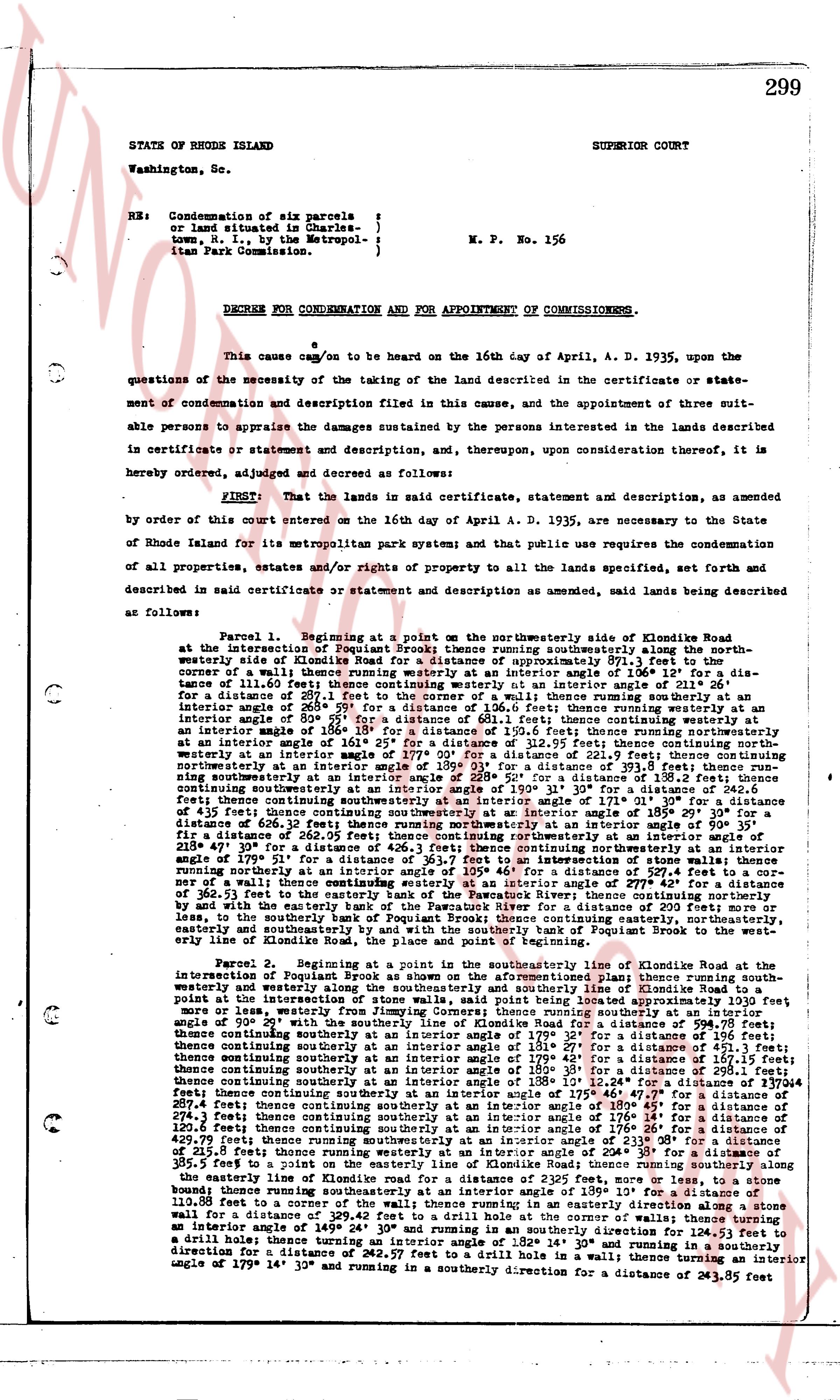
299
STATE OF RHODE ISLAND SUPERIOR COURT
Washington, Sc.
RE: { Condemnation of six parcels
{ or land situated in Charles-
{ town, R. I., by the Metropol-
{ itan Park Commission
M. P. No. 156
DECREE FOR CONDEMNATION AND FOR APPOINTMENT OF COMMISSIONERS.
$\text{---}$
This cause came on board here on the 16th day of April, A. D. 1935, upon the questions of the necessity of the taking of the land described in the certificate or statement of condemnation and description filed in this cause, and the appointment of three suitable persons to appraise the damages sustained by the persons interested in the lands described in certificate or statement and description, and, thereupon, upon consideration thereof, it is hereby ordered, adjudged and decreed as follows:
FIRST: That the lands in said certificate, statement and description, as amended by order of this court entered on the 16th day of April A. D. 1935, are necessary to the State of Rhode Island for its metropolitan park system; and that public use requires the condemnation of all property, estates and/or rights of property to all the lands specified, being set forth and described in said certificate or statement and description as amended, said lands being described as follows:
Parcel 1. Beginning at a point on the northeasterly side of Ellsmore Road at the intersection of Pequot Brook; thence running southeasterly along the northeasterly side of Ellsmore Road for a distance of approximately 871.1 feet to a corner of a wall; thence running westerly at an interior angle of 104$\text{o}$ 1' for a distance of one 1/2 foot; thence running southeasterly at an interior angle of 115$\text{o}$ 59' for a distance of 207.1 feet to the corner of a wall; thence running southerly at an interior angle of 80$\text{o}$ 1' for a distance of 601.1 feet; thence continuing westerly at an interior angle of 101$\text{o}$ 5' for a distance of 111.1 feet; thence continuing southeasterly at an interior angle of 101$\text{o}$ 25' for a distance of 132.95 feet; thence continuing northwesterly at an interior angle of 111$\text{o}$ 35' for a distance of 111.1 feet; thence continuing northwesterly at an interior angle of 118$\text{o}$ 30' for a distance of 393.1 feet; thence continuing northwesterly at an interior angle of 139$\text{o}$ 31' for a distance of 393.1 feet; thence running southeasterly at an interior angle of 118$\text{o}$ 30' for a distance of 111.1 feet; thence continuing southeasterly at an interior angle of 109$\text{o}$ 31' for a distance of 242.6 feet; thence continuing southeasterly at an interior angle of 111$\text{o}$ 35' for a distance of 132.95 feet; thence continuing southeasterly at an interior angle of 101$\text{o}$ 5' for a distance of 435 feet; thence continuing southeasterly at interior angle of 185$\text{o}$ 29' 31" for a distance of 462.9 feet; thence running southeasterly at an interior angle of 115$\text{o}$ 59' for a distance of 262.95 feet; thence continuing southeasterly at interior angle of 185$\text{o}$ 29' 31" for a distance of 262.95 feet; thence continuing northwesterly at an interior angle of 218$\text{o}$ 29' 31" for a distance of 428.6 feet; thence continuing northwesterly at an interior angle of 218$\text{o}$ 29' 31" for a distance of 428.6 feet; thence continuing northwesterly at an interior angle of 179$\text{o}$ 0' for a distance of 456.4 feet; thence continuing southeasterly at an interior angle of 179$\text{o}$ 0' for a distance of 456.4 feet; thence continuing southeasterly at an interior angle of 179$\text{o}$ 0' for a distance of 456.4 feet; thence running northerly at an interior angle of 179$\text{o}$ 0' for a distance of 456.4 feet; thence continuing northeasterly at an interior angle of 179$\text{o}$ 0' for a distance of 456.4 feet to the center line of the Pawcatuck River; thence continuing northeasterly by the center line of the Pawcatuck River for a distance of 456.4 feet; thence continuing northeasterly for a distance of 363.53 feet to the easterly bank of Pequot Brook; thence continuing easterly, northeasterly, easterly and southeasterly along the easterly bank of Pequot Brook for a distance of 1,111.1 feet, to the center line of Ellsmore Road, the place of point and beginning of the tract.
Parcel 2. Beginning at a point in the southeasterly line of Ellsmore Road at the intersection of Pequot Brook; thence running southeasterly along the center line thence running southeasterly and westerly along the southeasterly and southerly line of Ellsmore Road to a point, the distance being 871.1 feet; thence running southeasterly at an interior angle of 115$\text{o}$ 59' more or less, westerly from Jumping Corner; thence running southeasterly at an interior angle of 115$\text{o}$ 59' for a distance of 207.1 feet; thence continuing southeasterly at an interior angle of 179$\text{o}$ 32' for a distance of 196 feet; thence continuing southeasterly at an interior angle of 179$\text{o}$ 32' for a distance of 196 feet; thence continuing southeasterly at an interior angle of 179$\text{o}$ 42' for a distance of 167.15 feet; thence continuing southeasterly at an interior angle of 189$\text{o}$ 35" for a distance of 299.1 feet; thence continuing southeasterly at an interior angle of 189$\text{o}$ 35" for a distance of 299.1 feet; thence continuing southeasterly at an interior angle of 176$\text{o}$ 46' 47" for a distance of 287.4 feet; thence continuing southeasterly at an interior angle of 176$\text{o}$ 46' 47" for a distance of 287.4 feet; thence continuing southeasterly at an interior angle of 176$\text{o}$ 46' 14" for a distance of 128.3 feet; thence continuing southeasterly at an interior angle of 176$\text{o}$ 46' 14" for a distance of 287.43 feet; thence continuing southeasterly at an interior angle of 176$\text{o}$ 46' 14" for a distance of 128.3 feet; thence continuing southeasterly at an interior angle of 218$\text{o}$ 0' for a distance of 129.3 feet; thence continuing southeasterly at an interior angle of 218$\text{o}$ 0' for a distance of 129.3 feet; thence continuing southeasterly at an interior angle of 218$\text{o}$ 0' for a distance of 385.5 feet to a point on the easterly line of Ellsmore Road; thence running southeasterly along the easterly line of Ellsmore Road to the center line of Pequot Brook, the place of bound; thence running southeasterly at an interior angle of 189$\text{o}$ 19' for a distance of 110.88 feet to a corner of the wall; thence running in an easterly direction along a stone wall for a distance of 111.1 feet; thence running southeasterly at an interior angle of 149$\text{o}$ 24' 30" and running in a southerly direction for 124.53 feet to a drill hole; thence running southeasterly at an interior angle of 149$\text{o}$ 24' 30" for a distance of 242.57 feet to a drill hole in a wall; thence running southeasterly at an interior angle of 179$\text{o}$ 14' 30" and running in a southerly direction for a distance of 243.05 feet
The page as recorded