The instrument's own words
page 1 · read by Gemma vision
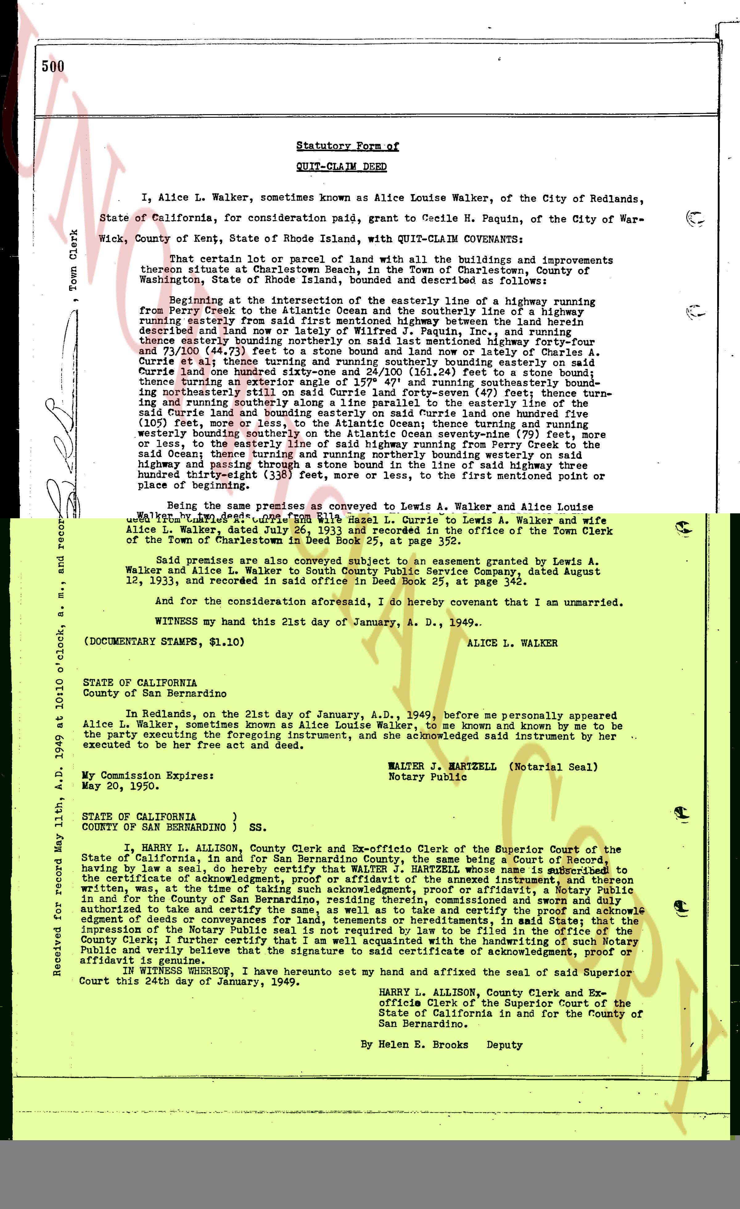
500
Statutory Form of
QUIT-CLAIM DEED
I, Alice L. Walker, sometimes known as Alice Louise Walker, of the City of Redlands, State of California, for consideration paid, grant to Cecile H. Paquin, of the City of Warwick, County of Kent, State of Rhode Island, with QUIT-CLAIM COVENANTS:
That certain lot 1 or parcel of land with all the buildings and improvements thereon situated in the Town of Charlestown, County of Washington, State of Rhode Island, bounded and described as follows:
Beginning at the intersection of the easterly line of a highway running from Perry Creek to the Atlantic ocean and the southerly line of a highway running easterly from said Perry Creek to the Atlantic ocean between the land of Charles A. Curdie described and now late of Wilfred J. Paquin, inc, and running thence easterly along said southerly line of the aforementioned highway four-four and 71/100 (44.71) feet to a stone bound and line of late Charles A. Curdie; thence running southerly along the easterly line of said Curdie land to a stone bound; thence running northeasterly still on said Curdie land forty seven-24/100 (47.24) feet to a stone bound; thence running northeasterly still on said Curdie land forty seven-20/100 (47.20) feet; thence turning northwesterly still on said Curdie land forty seven-20/100 (47.20) feet; thence turning northwesterly still on said Curdie land one hundred five (105) feet; thence turning northeasterly still on said Curdie land one hundred five (105) feet; thence turning northeasterly still on said Curdie land one hundred five (105) feet; thence turning northeasterly still on said Curdie land one hundred five (105) feet; thence turning northeasterly still on said Curdie land one hundred five (105) feet; thence turning northeasterly still on said Curdie land one hundred five (105) feet; thence turning northeasterly still on said Curdie land one hundred five (105) feet; thence turning northeasterly still on said Curdie land one hundred five (105) feet; thence turning northeasterly still on said Curdie land one hundred five (105) feet; thence turning northeasterly still on said Curdie land one hundred five (105) feet; thence turning northeasterly still on said Curdie land one hundred five (105) feet; thence turning northeasterly still on said Curdie land one hundred five (105) feet; thence turning northeasterly still on said Curdie land one hundred five (105) feet; thence turning northeasterly still on said Curdie land one hundred five (105) feet; thence turning northeasterly still on said Curdie land one hundred five (105) feet; thence turning northeasterly still on said Curdie land one hundred five (105) feet; thence turning northeasterly still on said Curdie land one hundred five (105) feet; thence turning northeasterly still on said Curdie land one hundred five (105) feet; thence turning northeasterly still on said Curdie land one hundred five (105) feet; thence turning northeasterly still on said Curdie land one hundred five (105) feet; thence turning northeasterly still on said Curdie land one hundred five (105) feet; thence turning northeasterly still on said Curdie land one hundred five (105) feet; thence turning northeasterly still on said Curdie land one hundred five (105) feet; thence turning northeasterly still on said Curdie land one hundred five (105) feet; thence turning northeasterly still on said Curdie land one hundred five (105) feet; thence turning northeasterly still on said Curdie land one hundred five (105) feet; thence turning northeasterly still on said Curdie land one hundred five (105) feet; thence turning northeasterly still on said Curdie land one hundred five (105) feet; thence turning northeasterly still on said Curdie land one hundred five (105) feet; thence turning northeasterly still on said Curdie land one hundred five (105) feet; thence turning northeasterly still on said Curdie land one hundred five (105) feet; thence turning northeasterly still on said Curdie land one hundred five (105) feet; thence turning northeasterly still on said Curdie land one hundred five (105) feet; thence turning northeasterly still on said Curdie land one hundred five (105) feet; thence turning northeasterly still on said Curdie land one hundred five (105) feet; thence turning northeasterly still on said Curdie land one hundred five (105) feet; thence turning northeasterly still on said Curdie land one hundred five (105) feet; thence turning northeasterly still on said Curdie land one hundred five (105) feet; thence turning northeasterly still on said Curdie land one hundred five (105) feet; thence turning northeasterly still on said Curdie land one hundred five (105) feet; thence turning northeasterly still on said Curdie land one hundred five (105) feet; thence turning northeasterly still on said Curdie land one hundred five (105) feet; thence turning northeasterly still on said Curdie land one hundred five (105) feet; thence turning northeasterly still on said Curdie land one hundred five (105) feet; thence turning northeasterly still on said Curdie land one hundred five (105) feet; thence turning northeasterly still on said Curdie land one hundred five (105) feet; thence turning northeasterly still on said Curdie land one hundred five (105) feet; thence turning northeasterly still on said Curdie land one hundred five (105) feet; thence turning northeasterly still on said Curdie land one hundred five (105) feet; thence turning northeasterly still on said Curdie land one hundred five (105) feet; thence turning northeasterly still on said Curdie land one hundred five (105) feet; thence turning northeasterly still on said Curdie land one hundred five (105) feet; thence turning northeasterly still on said Curdie land one hundred five (105) feet; thence turning northeasterly still on said Curdie land one hundred five (105) feet; thence turning northeasterly still on said Curdie land one hundred five (105) feet; thence turning northeasterly still on said Curdie land one hundred five (105) feet; thence turning northeasterly still on said Curdie land one hundred five (105) feet; thence turning northeasterly still on said Curdie land one hundred five (105) feet; thence turning northeasterly still on said Curdie land one hundred five (105) feet; thence turning northeasterly still on said Curdie land one hundred five (105) feet; thence turning northeasterly still on said Curdie land one hundred five (105) feet; thence turning northeasterly still on said Curdie land one hundred five (105) feet; thence turning northeasterly still on said Curdie land one hundred five (105) feet; thence turning northeasterly still on said Curdie land one hundred five (105) feet; thence turning northeasterly still on said Curdie land one hundred five (105) feet; thence turning northeasterly still on said Curdie land one hundred five (105) feet; thence turning northeasterly still on said Curdie land one hundred five (105) feet; thence turning northeasterly still on said Curdie land one hundred five (105) feet; thence turning northeasterly still on said Curdie land one hundred five (105) feet; thence turning northeasterly still on said Curdie land one hundred five (105) feet; thence turning northeasterly still on said Curdie land one hundred five (105) feet; thence turning northeasterly still on said Curdie land one hundred five (105) feet; thence turning northeasterly still on said Curdie land one hundred five (105) feet; thence turning northeasterly still on said Curdie land one hundred five (105) feet; thence turning northeasterly still on said Curdie land one hundred five (105) feet; thence turning northeasterly still on said Curdie land one hundred five (105) feet; thence turning northeasterly still on said Curdie land one hundred five (105) feet; thence turning northeasterly still on said Curdie land one hundred five (105) feet; thence turning northeasterly still on said Curdie land one hundred five (105) feet; thence turning northeasterly still on said Curdie land one hundred five (105) feet; thence turning northeasterly still on said Curdie land one hundred five (105) feet; thence turning northeasterly still on said Curdie land one hundred five (105) feet; thence turning northeasterly still on said Curdie land one hundred five (105) feet; thence turning northeasterly still on said Curdie land one hundred five (105) feet; thence turning northeasterly still on said Curdie land one hundred five (105) feet; thence turning northeasterly still on said Curdie land one hundred five (105) feet; thence turning northeasterly still on said Curdie land one hundred five (105) feet; thence turning northeasterly still on said Curdie land one hundred five (105) feet; thence turning northeasterly still on said Curdie land one hundred five (105) feet; thence turning northeasterly still on said Curdie land one hundred five (105) feet; thence turning northeasterly still on said Curdie land one hundred five (105) feet; thence turning northeasterly still on said Curdie land one hundred five (105) feet; thence turning northeasterly still on said Curdie land one hundred five (105) feet; thence turning northeasterly still on said Curdie land one hundred five (105) feet; thence turning northeasterly still on said Curdie land one hundred five (105) feet; thence turning northeasterly still on said Curdie land one hundred five (105) feet; thence turning northeasterly still on said Curdie land one hundred five (105) feet; thence turning northeasterly still on said Curdie land one hundred five (105) feet; thence turning northeasterly still on said Curdie land one hundred five (105) feet; thence turning northeasterly still on said Curdie land one hundred five (105) feet; thence turning northeasterly still on said Curdie land one hundred five (105) feet; thence turning northeasterly still on said Curdie land one hundred five (105) feet; thence turning northeasterly still on said Curdie land one hundred five (105) feet; thence turning northeasterly still on said Curdie land one hundred five (105) feet; thence turning northeasterly still on said Curdie land one hundred five (105) feet; thence turning northeasterly still on said Curdie land one hundred five (105) feet; thence turning northeasterly still on said Curdie land one hundred five (105) feet; thence turning northeasterly still on said Curdie land one hundred five (105) feet; thence turning northeasterly still on said Curdie land one hundred five (105) feet; thence turning northeasterly still on said Curdie land one hundred five (105) feet; thence turning northeasterly still on said Curdie land one hundred five (105) feet; thence turning northeasterly still on said Curdie land one hundred five (105) feet; thence turning northeasterly still on said Curdie land one hundred five (105) feet; thence turning northeasterly still on said Curdie land one hundred five (105) feet; thence turning northeasterly still on said Curdie land one hundred five (105) feet; thence turning northeasterly still on said Curdie land one hundred five (105) feet; thence turning northeasterly still on said Curdie land one hundred five (105) feet; thence turning northeasterly still on said Curdie land one hundred five (105) feet; thence turning northeasterly still on said Curdie land one hundred five (105) feet; thence turning northeasterly still on said Curdie land one hundred five (105) feet; thence turning northeasterly still on said Curdie land one hundred five (105) feet; thence turning
page 2 · read by Gemma vision
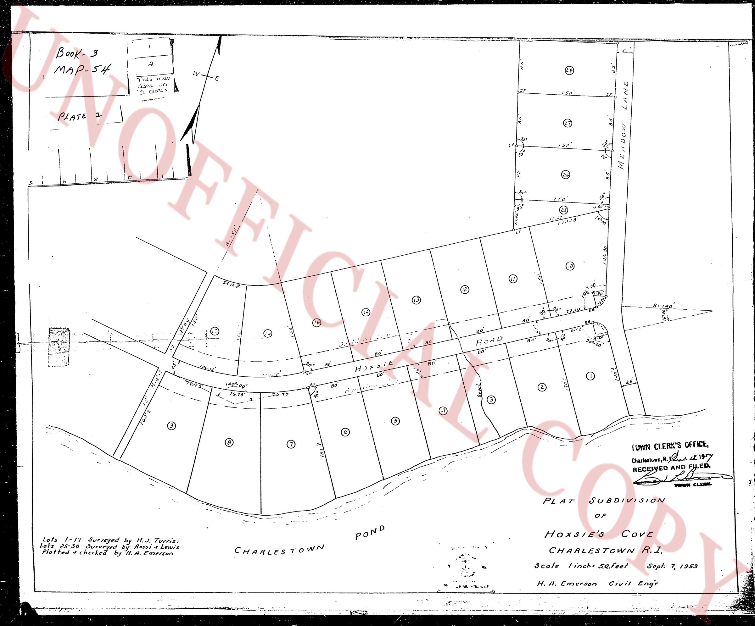
Book- 3
MAP 54
PLATE 2
This map
shows
3 lots
3 roads
[Diagram of a land subdivision plat showing various lots, road layouts, and measurements. The main road is labeled "HOXSIE ROAD" and a side road is labeled "MEADOW LANE". The map includes a north arrow and a scale.]
Lots 1-17 Surveyed by H. J. Turris
Lots 28-38 Surveyed by Boss & Lewis
Plotted & checked by H. A. Emerson
CHARLESTOWN POND
PLAT SUBDIVISION
of
HOXSIE'S COVE
CHARLESTOWN R.I.
Scale 1 inch= 50 feet Sept. 7, 1939
H. A. Emerson Civil Engr
TOWN CLERK'S OFFICE,
Charlestown, R.I. May 11, 1949
RECEIVED AND FILED.
[Signature]
TOWN CLERK
The page as recorded