The instrument's own words
page 1 · read by Gemma vision
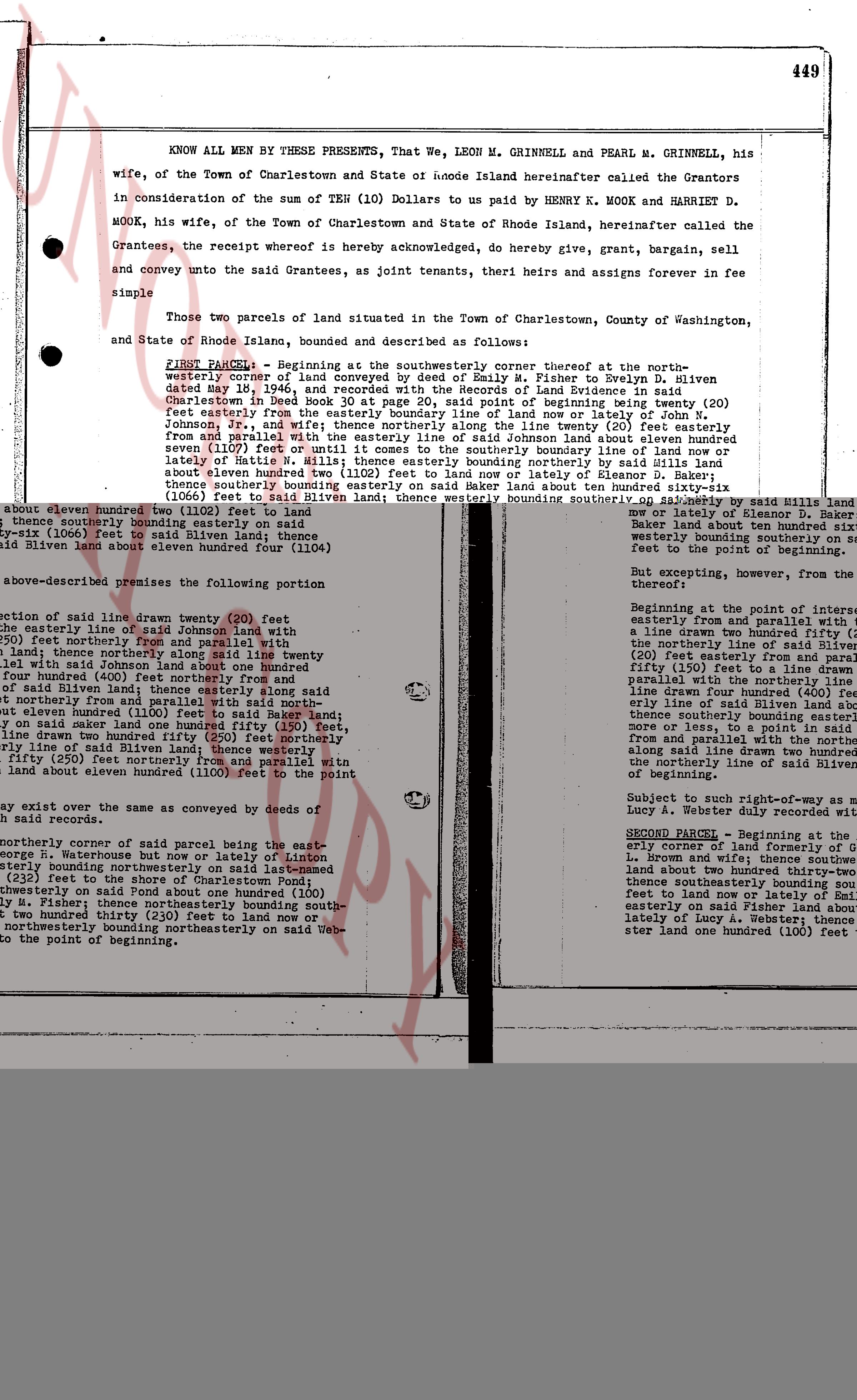
449
KNOW ALL MEN BY THESE PRESENTS, That We, LEON M. GRINNELL and PEARL M. GRINNELL, his wife, of the Town of Charlestown and State of Rhode Island hereinafter called the Grantors in consideration of the sum of TEN (10) Dollars to us paid by HENRY K. MOOK and HARRIET D. MOOK, his wife, of the Town of Charlestown and State of Rhode Island, hereinafter called the Grantees, the receipt whereof is hereby acknowledged, do hereby give, grant, bargain, sell and convey unto the said Grantees, as joint tenants, their heirs and assigns forever in fee simple
Those two parcels of land situated in the Town of Charlestown, County of Washington, and State of Rhode Island, bounded and described as follows:
FIRST PARCEL: Beginning at the southeasterly corner thereof at the northeasterly corner of land of Emily P. Silver to Evelyn D. Silver dated May 18, 1946, and recorded with the Records of Land Evidence in said Charlestown in Book 24 page 111; thence running southeasterly twenty (20) feet easterly from the easterly boundary line of land now or lately of John N. Johnson, Jr., and wife; thence northerly along the line twenty (20) feet easterly from the public road called the Charlestown-Charlestown Neck road; thence running south eleven (1107) feet or until it comes to the southerly boundary line of land now or lately of estate of late Sarah Silver; thence running easterly one hundred (100) feet to land now or lately of Eleanor D. Baker; thence running southerly one hundred (100) feet to land now or lately of estate of late Sarah Silver; thence running westerly one hundred (100) feet to said Silver land; thence westerly bounding southerly on said Silver land about one hundred twenty eight (128) feet to said Silver land; thence running northerly along the line twenty (20) feet easterly from the public road called the Charlestown-Charlestown Neck road about eleven hundred four (1104) feet to the point of beginning.
But excepting, however, from the above-described premises the following portion:
Beginning at the point of intersection of the public road called the Charlestown-Charlestown Neck road and the easterly line of said Johnson land; thence drawn twenty (20) feet easterly from the easterly line of said Johnson land; thence northerly along said line twenty (20) feet easterly from the public road called the Charlestown-Charlestown Neck road; thence running south four hundred (400) feet northerly from and parallel with the public road called the Charlestown-Charlestown Neck road; thence easterly one hundred (100) feet to land now or lately of said Silver land; thence running northerly along the line twenty (20) feet easterly from the public road called the Charlestown-Charlestown Neck road one hundred (100) feet; thence drawn twenty (20) feet northerly from and parallel with the public road called the Charlestown-Charlestown Neck road; thence running south fifty (50) feet northerly from and parallel with the public road called the Charlestown-Charlestown Neck road; thence running easterly one hundred (100) feet to land now or lately of said Silver land; thence running southerly along the line twenty (20) feet easterly from the public road called the Charlestown-Charlestown Neck road about eleven hundred (1100) feet to the point of beginning.
Subject to such easements as may be conveyed by deeds of record.
SECOND PARCEL: Beginning at the easterly corner of land of Ford and wife; thence running southeasterly to L. Brown and wife; thence southeasterly about two hundred thirty-two (232) feet to the shore of Charlestown Pond; thence running northerly along said Pond about one hundred (100) feet to land now or lately of M. Fisher; thence running northeasterly about two hundred thirty (230) feet to land now or lately of Lucy A. Webster; thence running northwesterly bounding northeasterly on said Webster land to the point of beginning.
[Right margin text:]
Beginning at the point of intersection of the public road called the Charlestown-Charlestown Neck road and the easterly line of said Silver land; thence running northerly along the line twenty (20) feet easterly from the public road called the Charlestown-Charlestown Neck road about one hundred twenty eight (128) feet to said Silver land; thence running easterly one hundred (100) feet to said Silver land; thence running northerly along the line twenty (20) feet easterly from the public road called the Charlestown-Charlestown Neck road about eleven hundred four (1104) feet to the point of beginning.
Beginning at the point of intersection of the public road called the Charlestown-Charlestown Neck road and the easterly line of said Silver land; thence running northerly along the line twenty (20) feet easterly from the public road called the Charlestown-Charlestown Neck road to land now or lately of Eleanor D. Baker land about ten hundred ninety six (1096) feet; thence running easterly one hundred (100) feet to land now or lately of Eleanor D. Baker land about ten hundred ninety six (1096) feet; thence westerly bounding southerly on said Baker land about ten hundred ninety six (1096) feet to said Silver land; thence running southerly along the line twenty (20) feet easterly from the public road called the Charlestown-Charlestown Neck road about one hundred twenty eight (128) feet to the point of beginning.
But excepting, however, from the above-described premises the following portion:
Beginning at the point of intersection of the public road called the Charlestown-Charlestown Neck road and the easterly line of said Silver land; thence running easterly from and parallel with the public road called the Charlestown-Charlestown Neck road a line drawn two hundred fifty (250) feet; thence running northerly along the line twenty (20) feet easterly from and parallel with the public road called the Charlestown-Charlestown Neck road about four hundred (400) feet; thence running easterly one hundred (100) feet to land now or lately of said Silver land; thence running southerly bounding easterly along the line twenty (20) feet easterly from and parallel with the northeasterly line of said Silver land about four hundred (400) feet to the northerly line of said Silver land; thence running westerly one hundred (100) feet to the point of beginning.
Subject to such right-of-way as may be recorded in the name of Lucy A. Webster duly referenced will be reserved.
page 2 · read by Gemma vision
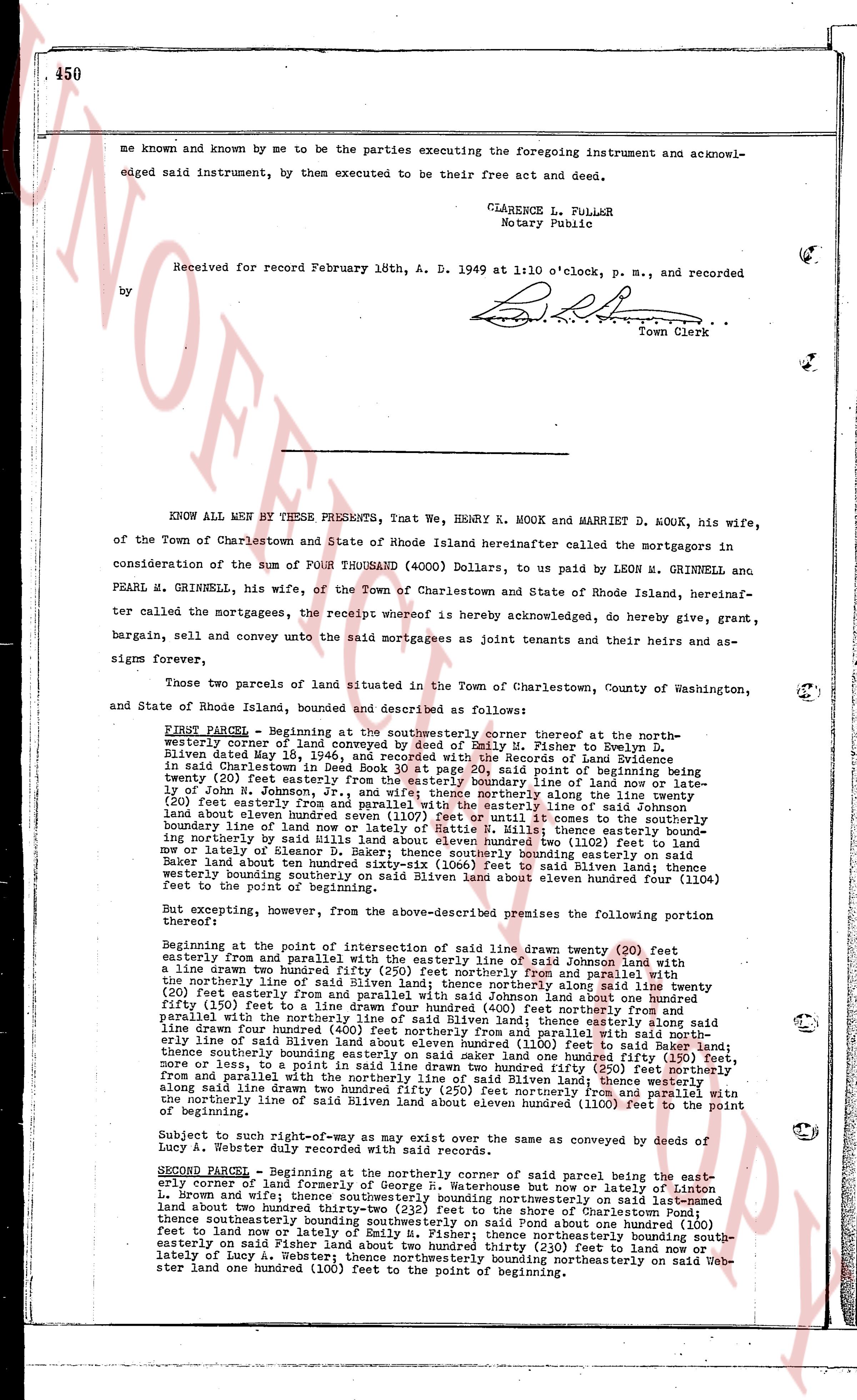
me known and known by me to be the parties executing the foregoing instrument and acknowledged said instrument, by them executed to be their free act and deed.
CLARENCE L. FULLER
Notary Public
Received for record February 18th, A. D. 1949 at 1:10 o'clock, p. m., and recorded
by [Signature]
Town Clerk
----
KNOW ALL MEN BY THESE PRESENTS, That We, HENRY K. MOOK and MARRIET D. MOOK, his wife, of the Town of Charlestown and State of Rhode Island hereinafter called the mortgagors in consideration of the sum of FOUR THOUSAND (4000) Dollars, to us paid by LEON M. GRINNELL and PEARL M. GRINNELL, his wife, of the Town of Charlestown and State of Rhode Island, hereinafter called the mortgagees, the receipt whereof is hereby acknowledged, do hereby give, grant, bargain, sell and convey unto the said mortgagees as joint tenants and their heirs and assigns forever,
Two parcels of land situated in the Town of Charlestown, County of Washington, and State of Rhode Island, bounded and described as follows:
FIRST PARCEL - Beginning at the southwesterner corner thereof at the northwesterner corner of land conveyed by deed of Emily M. Fisher to Evelyn D. Silven dated May 18, 1936 and recorded in the Records of Charlestown, Rhode Island in said Land Evidence Book 30 at page 20, said point of beginning now being twenty (20) feet easterly from the easterly boundary line of land now or lately of John M. Johnson, from said point running easterly from the easterly line of said Johnson land fifty (50) feet easterly from and parallel with the easterly line of said Johnson land three hundred fifty (350) feet northerly from and parallel with the westerly line of land now or lately of Nettie W. Mills; thence easterly bounding northerly line of land now or lately of Nettie W. Mills; thence easterly bounding northwesternly line of land now or lately of Eleanor D. Baker; thence southeasterly bounding easterly on said Baker land about ten feet (10 feet) from and parallel with the easterly line of said Baker land two hundred eleven hundred four (1104) feet; thence westerly bounding southerly on said Silven land about eleven hundred four (1104) feet to the point of beginning.
But excepting, however, from the above-described premises the following portion thereof:
Beginning at the point of intersection of easterly line of said town twenty (20) feet northerly from and parallel with the easterly line of said Johnson land with a line drawn twenty two (22) feet northerly from and parallel with the northerly line drawn two hundred fifty (250) feet easterly from and parallel with the northerly line of said Silven land; thence northerly along said line twenty (20) feet and easterly from and parallel with the northerly line of said Johnson land one hundred fifty (150) feet to a line drawn four hundred (400) feet northerly from and parallel with said northerly line of said Silven land; thence northerly along said line four hundred (400) feet northerly from and parallel with said northerly line of said Silven land to a line drawn four hundred (400) feet easterly from and parallel with said northerly line of said Silven land; thence southerly bounding easterly on said land one hundred fifty (150) feet, more or less, and easterly from and parallel with the northerly line of said Silven land twenty (20) feet northerly from and parallel with the northerly line of said hundred twenty five (225) feet northerly from and parallel with the northerly line of said hundred twenty five (225) feet northerly from and parallel with the northerly line of said Silven land one hundred (100) feet to the point of beginning.
Subject to such right-of-way as may exist over the same as conveyed by deeds of Lucy A. Webster, duly recorded with said records.
SECOND PARCEL - Beginning at the northerly corner of said parcel being the easterly corner of land now or lately of Lucy A. Webster and now or lately of Lincon L. Brown and with the southeasterly boundary line northerly on said land one hundred land two hundred thirty two (232) feet to the shore of Charlestown Pond; thence southeasterly along the shore of Charlestown Pond about one hundred (100) feet to land now or lately of Emily M. Fisher; thence northeasterly on said land (south-easterly on said Fisher land) about two hundred thirty (230) feet to land now or lately of Lucy A. Webster; thence northwesternly bounding northeasterly on said Webster land one hundred (100) feet to the point of beginning.
The page as recorded