The instrument's own words
page 1 · read by Gemma vision
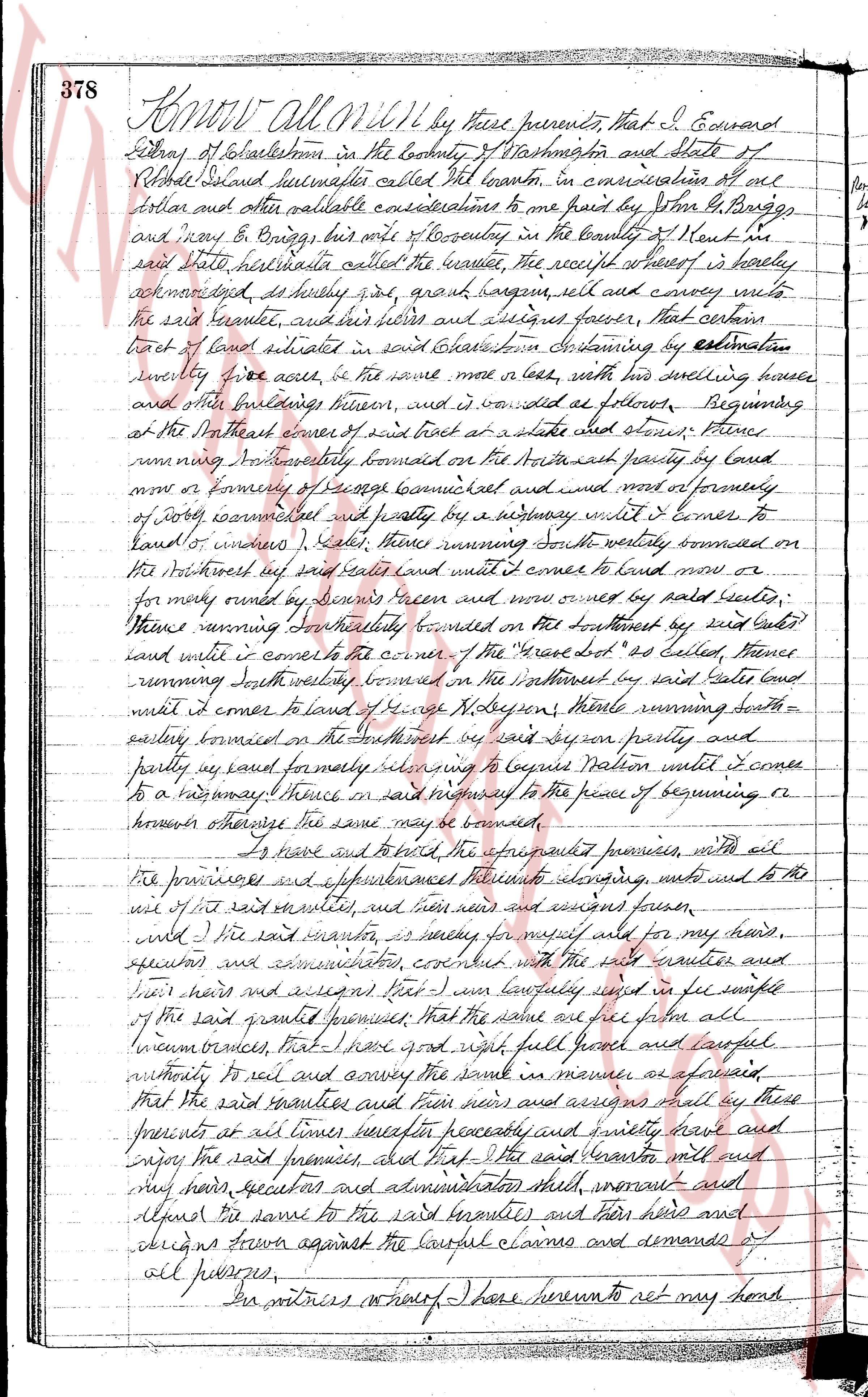
Know All Men by these presents, that I, Edward
Ditrey, of Charlestown in the County of Washington and State of
Rhode Island hereinafter called the grantor, in consideration of all
that certain and other valuable considerations to me paid by John B. Briggs,
and Mary B. Briggs, both of County in the County of Kent in
said state, hereinafter called the grantee, the receipt whereof is hereby
acknowledged, do hereby grant, bargain, sell and convey unto
the said Grantee, and his heirs and assigns forever, that certain
tract of land situated in said Charlestown containing by estimation
twenty five acres, or thereabouts, with his dwelling house
and other buildings thereon, and is described as follows: Beginning at
the Northwest corner of said tract at a stake and stones, then
running Northeasterly bounded on the Northeast part by land of
now or formerly of George Carmichael and now more or formerly,
of john carmichael and partly by a highway until it comes to
land of [?] (one), then running South westerly bounded on
the Northwest part said land until it comes to land now or
more formerly owned by Dennis Green and now owned by paid Grantee,
thence running South westerly bounded on the Southwest by said land
until it comes to the corner of the "Grave Lot" of Samuel France
running South westerly bounded on the Southwest by said land
until it comes to land of George N. Dobson, thence running South-
easterly bounded on the Southeast part by said land partly
and partly by said formerly referring to begin Nation until it comes
to a highway thence in said highway to the place of beginning or
however else the same may be described.
To have and to hold, the aforementioned premises, with all
the privileges and appurtenances thereunto belonging, unto and to the
use of the said grantees, and their heirs and assigns forever,
until the said grantor is ready to convey the same for my deads,
executors and administrators, connected with the said grantees and
their heirs and assigns that I am lawfully seized in fee simple
of the said granted premises; that the same are free from all
incumbrances that I have all right full good and lawful
authority to sell and convey the same in manner aforesaid,
that the said grantees and their heirs and assigns shall by these
presents at all times hereafter peaceably and quietly have and
enjoy the said premises and that I the said grantor will and
my heirs, executors and administrators shall warrant and
defend the same to the said grantees and their heirs and
assigns from against the lawful claims and demands of
all persons.
In witness whereof I have hereunto set my hand
page 2 · read by Gemma vision
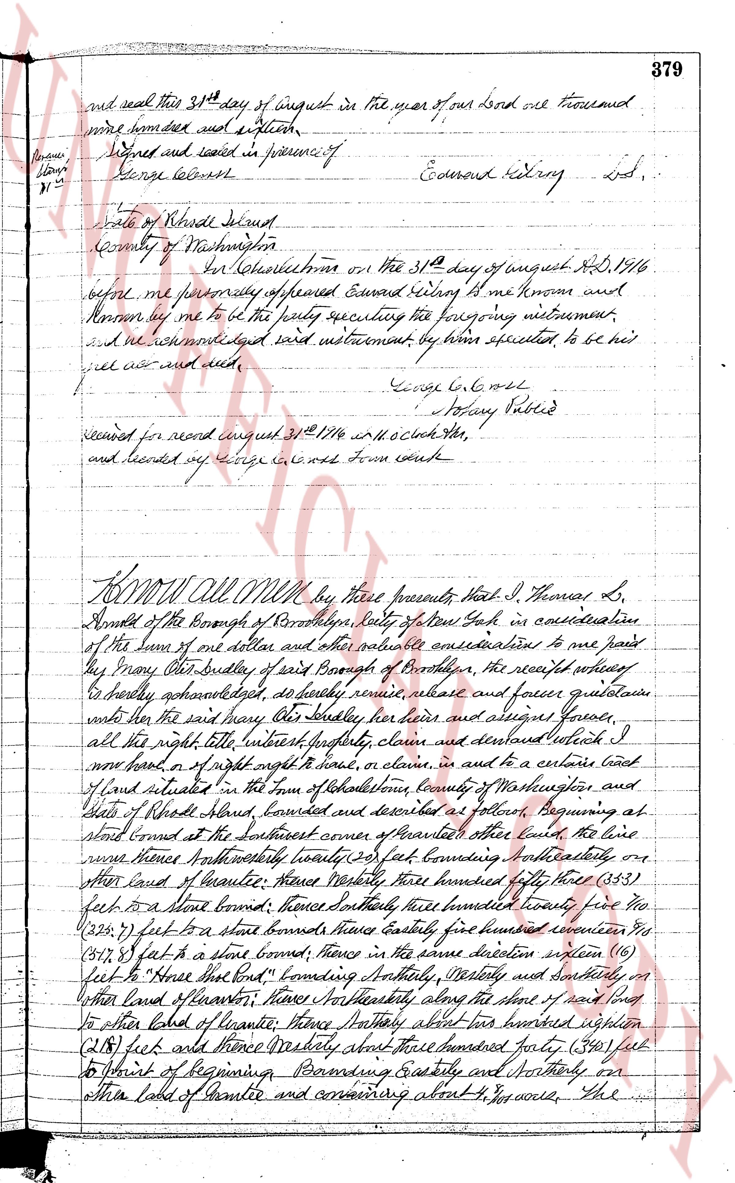
379
and seal this 31st day of august in the year of our Lord one thousand
nine hundred and sixteen
Signed and sealed in presence of
George L. Cox
[?]
31st
Edward Kidroy Lsd.
State of Rhode Island
County of Washington
In the Town of Charlestown on the 31st day of august A.D. 1916
before me personally appeared Edward Kidroy he is known and
known by me to be the party executing the foregoing instrument
and we acknowledged said instrument by him executed to be his
free act and deed.
George L. Cox
Notary Public
recorded read august 31st 1916 at 11 o clock a.m.
and recorded by George L. Cox Town clerk
----
KNOW All MEN by these presents That I, Thomas L.
Arnold of the Borough of Brooklyn, city of New York in consideration
of the sum of one dollar and other valuable considerations to me paid
by Mary Alice Bradley of said Borough of Brooklyn, the receipt whereof
I hereby acknowledge do hereby remise release and forever quitclaim
unto the said Mary Alice Bradley her heirs and assigns forever
all the right title interest legacy claim and demand which I
now have or of right ought to have or claim in and to a certain land
of land situated in the town of Charlestown, county of Washington and
state of Rhode Island, bounded and described as follows: Beginning at
stone bound at the southeast corner of Panton's land the line
runs thence northwesterly forty feet bounding northwesterly on
other land of Panton; thence westerly three hundred fifty three (353)
feet to a stone boundary; thence southeasterly three hundred forty five (345)
feet to a stone boundary; thence northwesterly three hundred seventeen (317)
feet to a stone boundary; thence in the same direction sixteen (16)
feet to "hence that part" bounding westerly westerly and southeasterly on
other land of Panton; thence northeasterly along the stone of said boundary
to other land of Panton; thence westerly about two hundred eighteen (218) feet
and thence westerly about three hundred forty (340) feet
on to point of beginning Bounding easterly and northerly on
other land of Panton and containing about 4 1/2 acres. The
The page as recorded