The Deed Walker · From Ninigret · Charlestown, Rhode Island land evidence, 1738 to today
Trail: 9724 › 386@65/643 › 207@26/477

9/10/1936 · PARTIAL RELEASE · book 26 page 477 doc 207@26/477

From BURDICK MARION GERTRUDE life, BURDICK EDWARD E life
To BEHNEKE MARIE R Y
Consideration consideration paid
Premises none · Tract in Sea Lea Colony bounded by First Street (Sea Lea Colony, Charlestown)
Index description SEE DOC

Back — where this land came from

mortgage Marie R. Y. Behneke book 25 p 147 Charlestown
“holders of a mortgage by Marie R. Y. Behneke... recorded in... book No. 25 at page 147”
◀ Follow back 1932 · MORTGAGE · BEHNEKE MARIE ROSE YVONNE; BEHNEKE NORMAN L → BURDICK EDWARD EDGAR; BURDICK MARION GERTRUDE · book 25 p 147
read by: gemma

The grantor's earlier acquisitions, by name — the man, not necessarily this land

◀ 1932 · MORTGAGE · BEHNEKE MARIE ROSE YVONNE; BEHNEKE NORMAN L → BURDICK EDWARD EDGAR; BURDICK MARION GERTRUDE · book 25 p 147
◀ 1921 · DEED · BROWNING STEPHEN T; BROWNING HANNAH J → BURDICK EDWARD E · book 19 p 460

Forward — where this land went

The grantee's later conveyances, by name — the man, not necessarily this land; the one that cites this deed as its source is the land

▶ 1936 · DEED · BEHNEKE MARIE R Y; BEHNEKE NORMAN L → CARD GERTRUDE I · book 26 p 478
▶ 1936 · DEED · BEHNEKE MARIE R Y; BEHNEKE NORMAN L → DE RING RACHEL S; DERING RACHEL S; DERING HERBERT H; DE RING HERBERT H · book 26 p 502
▶ 1937 · DEED · BEHNEKE MARIE R Y; BEHNEKE NORMAN L → DAWLEY GEORGE L; DAWLEY INGEBORG · book 27 p 11
▶ 1937 · DEED · BEHNEKE MARIE R Y; BEHNEKE NORMAN L → TWEEDELL FLORENCE L; TWEEDELL WILLIAM T · book 26 p 647
▶ 1965 · DEED · BEHNEKE MARIE R Y; BEHNEKE NORMAN L → DOBELSTEIN EMILY MILLICENT; DOBELSTEIN RUSSELL H · book 40 p 436
▶ 1966 · DEED · BEHNEKE MARIE R Y; BEHNEKE MARIE ROSE YVONNE; BEHNEKE NORMAN L → CROCKETT ELEANOR W; CROCKETT W DAVID · book 41 p 270
▶ 1966 · DEED · BEHNEKE MARIE R Y; BEHNEKE MARIE ROSE YVONNE; BEHNEKE NORMAN L → SEYMOUR KATHLEEN B; SEYMOUR RALPH B · book 41 p 302
▶ 1971 · DEED · BEHNEKE MARIE R Y; BEHNEKE NORMAN L → COMERFORD JOSEPH F; COMERFORD MARY E · book 45 p 90
▶ 1973 · DEED · BEHNEKE MARIE R Y → OLSEN ARNFINN; OLSEN ODDBJORG · book 48 p 223
▶ 1973 · DEED · BEHNEKE MARIE R Y → OLSEN ARNFINN; OLSEN ODDBJORG · book 48 p 511
▶ 1978 · NOTIC · BEHNEKE MARIE R Y → RHODE ISLAND STATE OF · book 59 p 721
▶ 1979 · NOTIC · BEHNEKE MARIE R Y → RHODE ISLAND STATE OF · book 62 p 549
▶ 1981 · CERTIFICATE · BEHNEKE MARIE R Y → · book 67 p 64
▶ 1981 · MISC · BEHNEKE MARIE R Y; BILLINGS BARBARA → BILLINGS BARBARA; BEHNEKE MARIE R Y · book 65 p 643
▶ 1985 · AGREEMENT · BEHNEKE MARIE R Y; BILLINGS BARBARA; FISCHER BODO H → FISCHER BODO H; BILLINGS BARBARA; BEHNEKE MARIE R Y · book 77 p 937
▶ 1986 · DEED · BEHNEKE MARIE R Y → FISCHER BODO H · book 85 p 728

Bounded by

Alfred Pearson

The instrument's own words

page 1 · read by Gemma vision
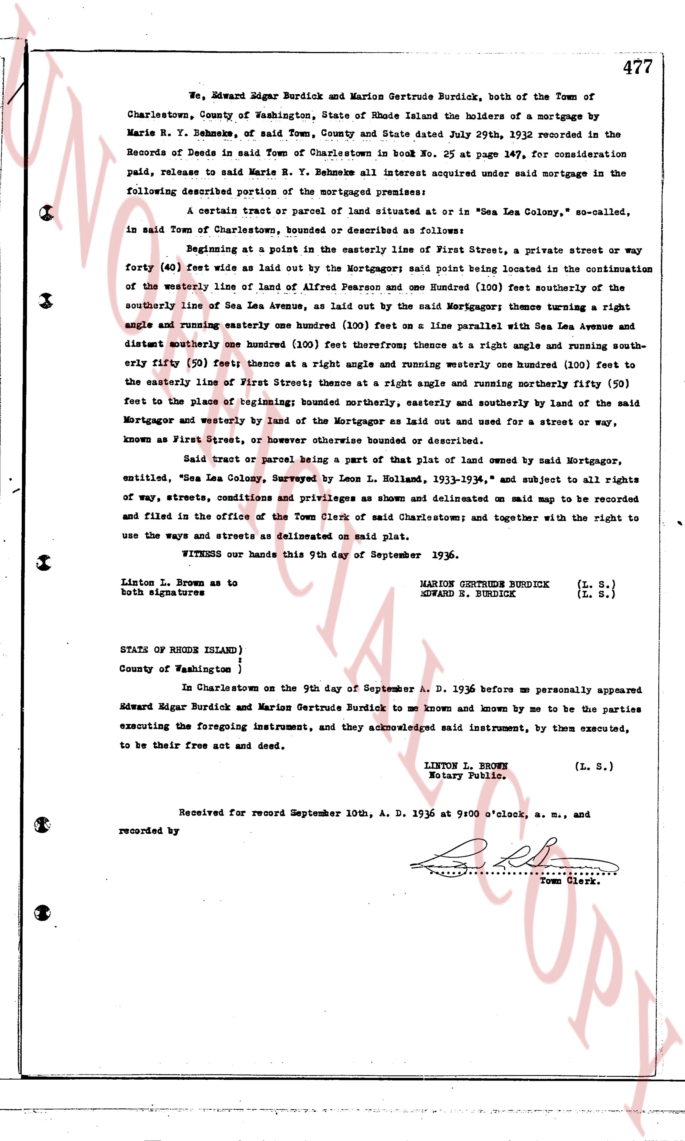
We, Edward Edgar Burdick and Marion Gertrude Burdick, both of the Town of Charlestown, County of Washington, State of Rhode Island the holders of a mortgage by Marie R. Y. Behneke, of said Town, County and State date July 29th, 1932 recorded in the Records of Deeds in said Town of Charlestown in book No. 25 on page 147, for consideration paid, release to said Marie R. Y. Behneke all interest acquired under said mortgage in the following described portion of the mortgaged premises: A certain tract or parcel of land situated at or in "Sea Lea Colony, so-called," in said Town of Charlestown, bounded and described as follows: Beginning at a point in the easterly line of First Street, a private street or way forty (40) feet wide as laid out by the Mortgagor said point being located in the continuation of the westerly line of land of Alfred Pearson and one Hundred (100) feet southerly the southerly line of Sea Lea Avenue, as laid out by the said Mortgagor; Thence turning a right angle and running easterly one hundred (100) feet on a line parallel with said Sea Lea Avenue and distant northerly one hundred (100) feet therefrom; thence at a right angle and running south- easterly fifty (50) feet; thence at a right angle and running westerly one hundred (100) feet to the easterly line of First Street; thence at a right angle and running northerly fifty (50) feet to the place of beginning; bounded northerly, easterly and southerly by land of the said Mortgagor and westerly by land of the Mortgagor as laid out and used for a street or way, known as First Street, or however otherwise bounded or described. Said tract or parcel being a part of that plot of land owned by said Mortgagor, entitled, "Sea Lea Colony, Surveyed by Leon L. Holland, 1933-1934," and subject to all rights of way, streets, conditions and privileges as shown and delineated on said map to be recorded and filed in the office of the Town Clerk of said Charlestown; and together with the right to use the ways and streets as delineated on said map. WITNESS our hands this 9th day of September 1936. Linton L. Brown as to MARION GERTRUDE BURDICK both signatures EDWARD E. BURDICK (L. S.) (L. S.) STATE OF RHODE ISLAND} County of Washington } In Charlestown on the 9th day of September A. D. 1936 before me personally appeared Edward Edgar Burdick and Marion Gertrude Burdick to me known and known by me to be the parties executing the foregoing instrument, and they acknowledged said instrument, by them executed, to be their free act and deed. LINTON L. BROWN Notary Public. (L. S.) Received for record September 10th, A. D. 1936 at 9:00 o'clock, a. m., and recorded by [Signature] Town Clerk.

The page as recorded
page 1

deed_walker_v1.9_2026-10-10 · the index is the town's own (i2l.uslandrecords.com); transcripts, chains and the assessor's cards are the Perry Machine's reading of it. Where the record we hold runs out, the page says so.