The instrument's own words
page 1 · read by Gemma vision
472
KNOW ALL MEN BY THESE PRESENTS, That I, LEAR S. BARBER, unmarried, of
Westerly, County of Washington, State of Rhode Island, For consideration paid
HAVE GRANTED CONVEYS TO Betty Florine Higgins and Raymond Thomas Joseph Higgins, husband and wife,
[?]
[?]
[?]
[?]
[?]
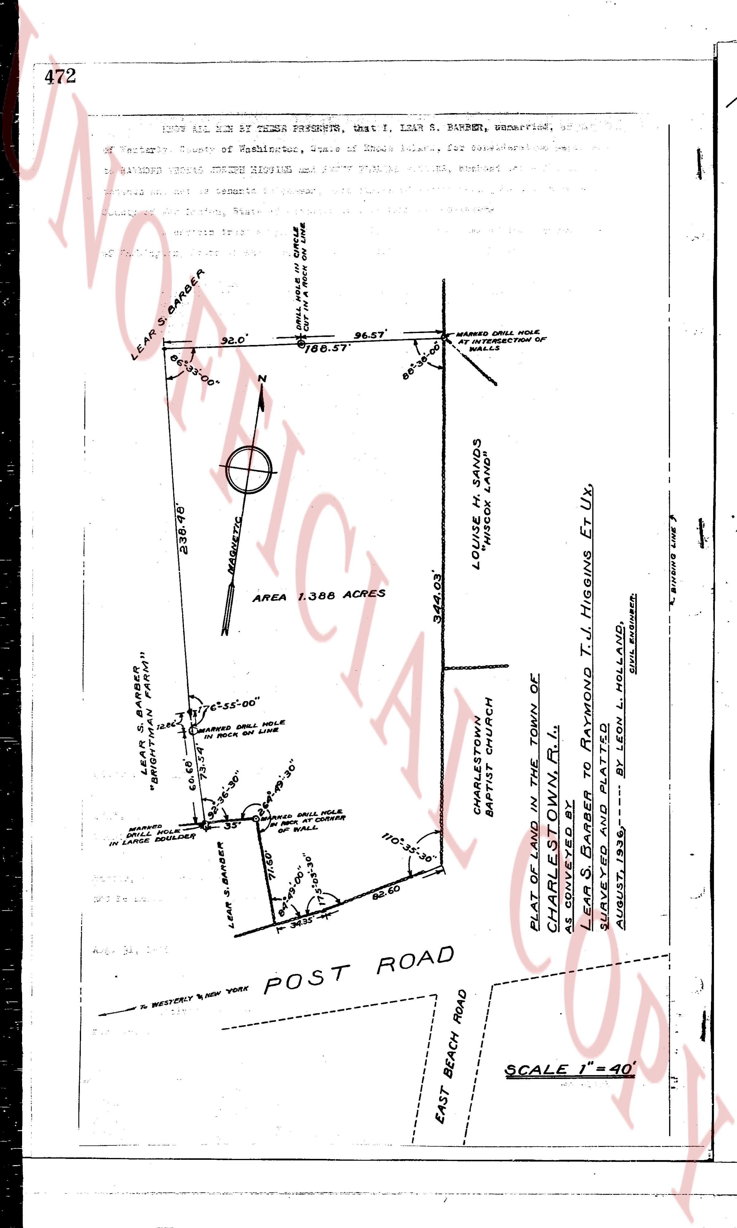
(Image contains a survey map with the following annotations):
LEAR S. BARBER
86° 35' 00"
32.0'
DRILL HOLE IN CIRCLE
CUT IN ROCK ON LINE
96.57'
186.57
86° 30' 00"
MARKED DRILL HOLE
AT INTERSECTION OF
WALLS
236.48'
NAUQUETIC
AREA 1.388 ACRES
344.03'
LOUISE M. SANDS
WIDOW SANDS
CHARLESTOWN
BAPTIST CHURCH
LEAR S. BARBER
"BRIGHTMAN FARMS"
66.00'
MARKED DRILL HOLE
IN ROCK ON LINE
66.00'
86° 35' 00"
MARKED DRILL HOLE
IN LARGE BOULDER
LEAR S. BARBER
71.00'
MARKED DRILL HOLE
IN CORNER
OF WALL
110° 35' 30"
75° 35' 30"
34.35'
82.60
PLAT OF LAND IN THE TOWN OF
CHARLESTOWN R.I.
AS CONVEYED BY
SURVEYED AND PLATTED
LEAR S. BARBER to RAYMOND T. J. HIGGINS Et Ux,
AUGUST, 1935 --- BY LEON L. HOLLAND
EAST BEACH ROAD
POST ROAD
TO WESTERLY NEW YORK
SCALE 1" = 40'
EDGERS LINE
(S.W. Corner)
page 2 · read by Gemma vision
472
KNOW ALL MEN BY THESE PRESENTS, that I, LEAR S. BARBER, unmarried, of
of Westerly, County of Washington, State of Rhode Island, for consideration
paid have granted unto BETTY FLORINE HIGGINS and RAYMOND THOMAS JOSEPH HIGGINS, husband
and wife, as tenants by the entirety,
[?]
[?]
[?]
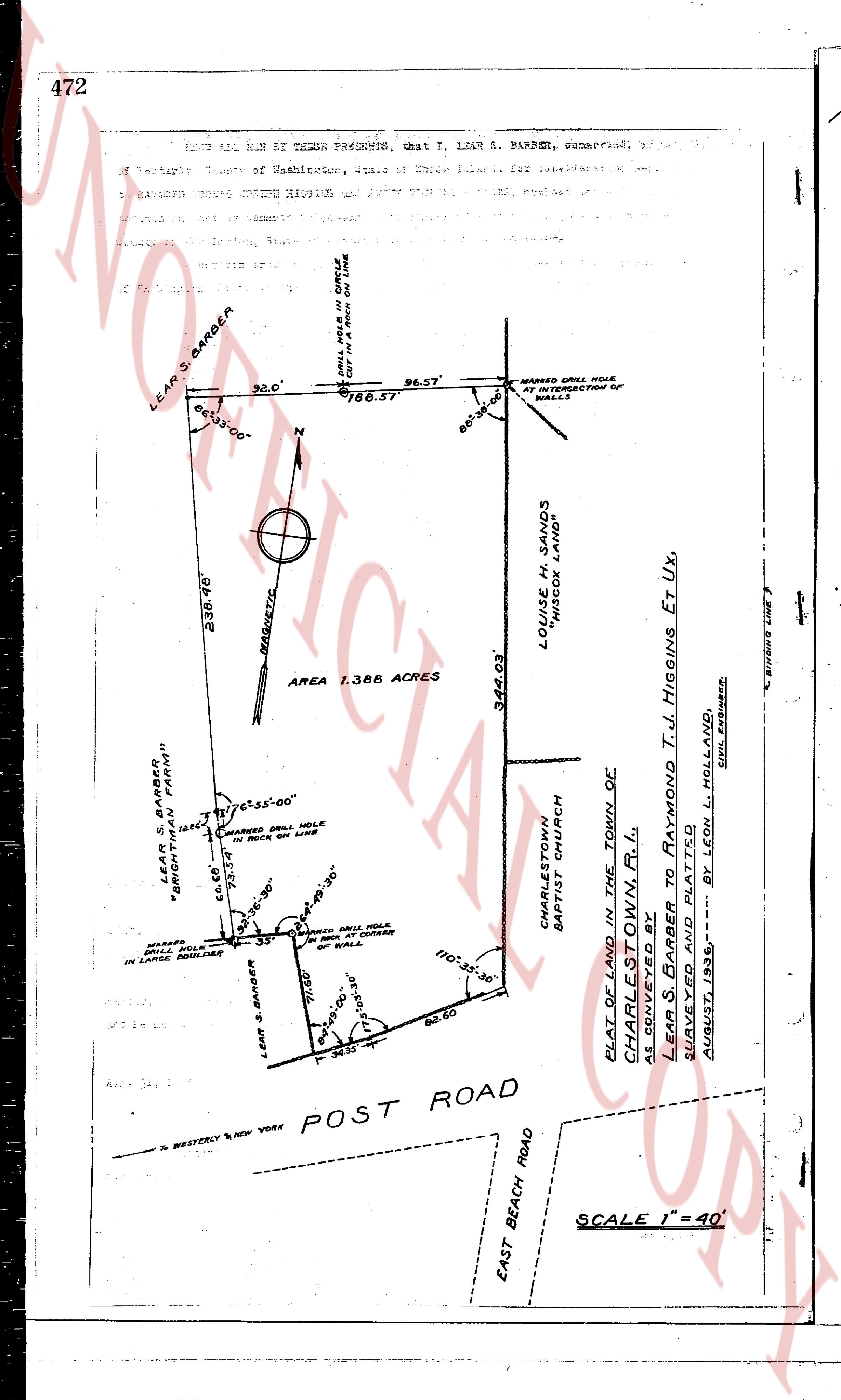
(Image of a survey map showing a parcel of land)
LEAR S. BARBER
86° 35' 00"
32.0'
DRILL HOLE IN CIRCLE
CUT IN ROCK ON LINE
186.57
96.57'
86° 35' 00"
MARKED DRILL HOLE
AT INTERSECTION OF
WALLS
236.48'
MAGNETIC
AREA 1.388 ACRES
344.03'
LOUISE M. SANDS
WIDOW SANDS
CHARLESTOWN
BAPTIST CHURCH
LEAR S. BARBER
"BRIGHTMAN FARMS"
66.00'
MARKED DRILL HOLE
IN ROCK ON LINE
6° 25' 00"
66.00'
86° 30' 00"
MARKED DRILL HOLE
IN LARGE BOULDER
LEAR S. BARBER
71.00'
MARKED DRILL HOLE
IN CORNER
OF WALL
110° 35' 30"
75° 35' 30"
34.35'
82.60
PLAT OF LAND IN THE TOWN OF
CHARLESTOWN R.I.
AS CONVEYED BY
LEAR S. BARBER to RAYMOND T. J. HIGGINS Et Ux,
SURVEYED AND PLATTED
AUGUST, 1935 --- BY LEON L. HOLLAND
To WESTERLY & NEW YORK POST ROAD
EAST BEACH ROAD
SCALE 1" = 40'
The page as recorded