The Deed Walker · From Ninigret · Charlestown, Rhode Island land evidence, 1738 to today
Trail: 8518 › 6555@37/290 › 1431@30/193

9/30/1946 · DEED · book 30 page 193 doc 1431@30/193

From HOPKINS DOROTHY L, HOPKINS STEWART D
To CORNELL FRANK H JR, CORNELL JOSEPHINE A
Consideration consideration paid
Premises one (1) acre, more or less · Tract on northerly side of State Highway (Charlestown, Carolina, Wood River Junction)
Index description SEE INSTRUMENT

Back — where this land came from

deed Raymond C. Hopkins and Grace D. Hopkins book 30 p 167 Charlestown
“Being the same premise conveyed by deed from Raymond C. Hopkins and Grace D. Hopkins to this Grantor”
◀ Follow back 1946 · DEED · HOPKINS GRACE D; HOPKINS RAYMOND C → HOPKINS STEWART D · book 30 p 167
read by: gemma

The grantor's earlier acquisitions, by name — the man, not necessarily this land

◀ 1946 · DEED · HOPKINS GRACE D; HOPKINS RAYMOND C → HOPKINS STEWART D · book 30 p 167

Forward — where this land went

Follow forward ▶ (an instrument we do not hold)
“Being the same premises conveyed by deed of Stewart S. Hopkins dated September 30th, 1946”
cites this instrument as its source · read by gemma
Follow forward ▶ (an instrument we do not hold)
“Being the same piece of land conveyed by deed of Stewart S. Hopkins dated September 30th, 1946”
cites this instrument as its source · read by gemma
Follow forward ▶ 1960 · DEED · CORNELL JOSEPHINE A; CORNELL FRANK H JR → POTTER HAROLD; POTTER MYRA K · book 37 p 290
“Being the same premises conveyed by deed of Stewart D. Hopkins dated September 30th, 1946”
cites this instrument as its source · read by gemma
Follow forward ▶ 1960 · DEED · POTTER HAROLD; POTTER MYRA K → CORNELL FRANK H JR; CORNELL JOSEPHINE A · book 37 p 290
“Being the same premises conveyed by deed of Stewart D. Hopkins dated September 30th, 1946”
cites this instrument as its source · read by gemma
Follow forward ▶ 1962 · MORTGAGE · CAPALBO FRANK J; CAPALBO JOSEPHINE H → WASHINGTON TRUST COMPANY · book 38 p 383
“Being the same premises conveyed to the mortgagors herein by Frank J. Capalbo and Sylvester J. Capalbo by deed dated August 29, 1952”
cites this instrument as its source · read by gemma

The grantee's later conveyances, by name — the man, not necessarily this land; the one that cites this deed as its source is the land

▶ 1948 · MORTGAGE · CORNELL JOSEPHINE A; CORNELL FRANK H JR → WASHINGTON TRUST COMPANY · book 30 p 652
▶ 1960 · DEED · CORNELL JOSEPHINE A; CORNELL FRANK H JR → POTTER HAROLD; POTTER MYRA K · book 37 p 290
▶ 1960 · MORTGAGE · CORNELL JOSEPHINE A; CORNELL FRANK H JR → WASHINGTON TRUST COMPANY · book 37 p 291
▶ 1977 · DEED · CORNELL JOSEPHINE A; CORNELL FRANK H JR → FACER WILLIAM A; YATES SUSAN ANN · book 56 p 968

Bounded by

William P. Sherman · Hiram L. Wright · Frank Cornell, Sr.

The instrument's own words

page 1 · read by Gemma vision
193 I, STEWART D. HOPKINS, of the Town of Westerly, County of Washington, State of Rhode Island, for consideration paid, grant to FRANK H. CORNELL, JR. and JOSEPHINE A. CORNELL, husband and wife, as Joint Tenants and not as Tenants in Common, meaning to the survivor, both of the Town of Charlestown, County of Washington, State of Rhode Island, with WARRANTY COVENANTS That certain tract or parcel of land, containing one (1) acre, more or less, situated on the northerly side of the State Highway leading westerly from the Village of Carolina to the Village of Wood River Junction, bounded and described as follows, and situate in said Town of Charlestown: BEGINNING at a point on the northerly side of said State Highway at the southwesterly corner of the premises William P. Sherman, et ux conveyed and at the southeasterly corner of the premises of William P. Sherman, et ux; thence running northerly, bounded by said Sherman's land, et ux, a distance of 340 feet, more or less, to land of Hiram L. Wright, et ux; thence turning and running easterly, bounded by said Wright's land, et ux, a distance of 125 feet; thence turning and running southerly, by said Wright's land, et ux, a distance of 125 feet; thence turning and running southerly, bounded easterly by land of Frank H. Cornell, Sr., a distance of 215 feet, more or less, to a point on said State Highway said last-mentioned point being 125 feet westerly at the place of beginning; thence turning and running westerly, bounded southerly by said State Highway, a distance of 125 feet, to the point of and place of beginning. Being the same premise conveyed by Deed from Raymond C. Hopkins and Grace D. Hopkins to this Grantor; said deed bearing date of September 21st, 1946 and recorded in the Records of Land Evidence, said Town of Charlestown, Book No. 30 at Page 167v reference to said deed and records thereof being hereby had and made and the same made a part hereof for a more complete and detailed description of the premises hereby conveyed. I, DOROTHY L. HOPKINS, wife of the grantor release to said grantees all my right of dower and all other interest in the aforementioned premises. WITNESS our hands this 30th day of September 1946. STEWART D. HOPKINS DOROTHY L. HOPKINS (DOCUMENTARY STAMPS, 55¢) STATE OF RHODE ISLAND, ETC.) County of Washington } } In Charlestown on the 30th day of September, 1946 before me personally appeared Stewart D. Hopkins and Dorothy L. Hopkins, husband and wife, both to me known and known by me to be the parties e-cuting the foregoing instrument, and they acknowledged said instrument, by them e-cuted, to be their free act and deed. RAYMOND G. VARS (Notarial Seal) Notary Public Received for record September 30th, A. D. 1946 at 5:00 o'clock, p. m., and recorded by [?] Town Clerk

The page as recorded
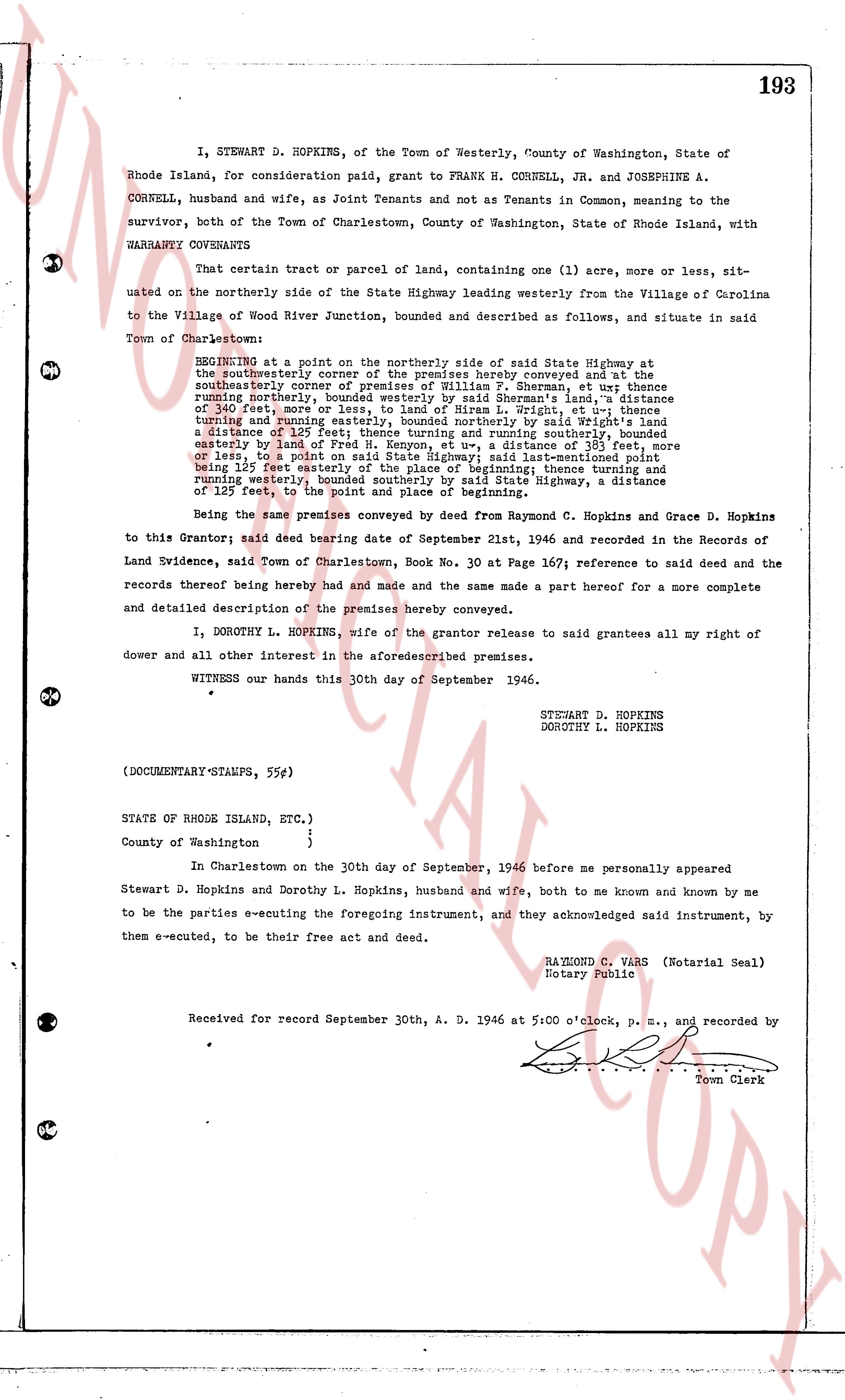
page 1

deed_walker_v1.9_2026-10-10 · the index is the town's own (i2l.uslandrecords.com); transcripts, chains and the assessor's cards are the Perry Machine's reading of it. Where the record we hold runs out, the page says so.