The Deed Walker · From Ninigret · Charlestown, Rhode Island land evidence, 1738 to today
Trail: 87@27/616 › 13@26/600

1/27/1937 · DEED · book 26 page 600 doc 13@26/600

From BAKER ELEANOR D life
To BAKER ELEANOR D life, BAKER ELSIE B, BAKER HOWARD H JR
Premises seven and four tenths (7.4) acres · lot or parcel of land with buildings and improvements (Charlestown, Niantic Drive, Niantic Air Port)
Index description NIANTIC DR

Back — where this land came from

This instrument states no source of title that we have read yet.

The grantor's earlier acquisitions, by name — the man, not necessarily this land

◀ 1936 · DEED · BROWN ALBERT E → BAKER ELEANOR D; BAKER HOWARD HAMILTON · book 26 p 333
◀ 1936 · MORTGAGE DISCHARGE · WAKEFIELD TRUST CO → BAKER HOWARD HAMILTON BY ATTORNEY; BAKER ELEANOR D · book 23 p 162
◀ 1936 · PARTIAL RELEASE · COLONIAL FINANCE CORPORATION → BAKER ELEANOR D · book 26 p 321
◀ 1936 · PARTIAL RELEASE · COLONIAL FINANCE CORPORATION → BAKER ELEANOR D · book 26 p 326
◀ 1936 · PARTIAL RELEASE · J N ADAMS CO INC → BAKER ELEANOR D · book 26 p 327
◀ 1936 · PARTIAL RELEASE · J N ADAMS CO INC → BAKER ELEANOR D · book 26 p 328
◀ 1936 · PARTIAL RELEASE · SARGENT PRTOER E → BAKER ELEANOR D · book 26 p 329
◀ 1936 · PARTIAL RELEASE · SARGENT PORTER E → BAKER ELEANOR D · book 26 p 330
◀ 1936 · DEED · BROWN ALBERT E → BAKER ELEANOR D · book 26 p 332
◀ 1935 · DEED · WAKEFIELD TRUST CO → BAKER ELEANOR D · book 26 p 154
◀ 1935 · PARTIAL RELEASE · COLONIAL FINANCE CORP → BAKER ELEANOR D · book 26 p 154
◀ 1935 · RELEASE STANDARD · J N ADAM & CO → BAKER ELEANOR D · book 26 p 155
◀ 1935 · RELEASE STANDARD · JH ADAMS & CO → BAKER ELEANOR D · book 24 p 525
◀ 1933 · PARTIAL RELEASE · WAKEFIELD TRUST CO → BAKER ELEANOR D · book 25 p 383

Forward — where this land went

The grantee's later conveyances, by name — the man, not necessarily this land; the one that cites this deed as its source is the land

▶ 1937 · DEED · BAKER ELSIE B; BAKER HOWARD H JR → TUCKER PERCY H · book 26 p 679
▶ 1938 · TAX SALE RETURN · FENNER NOEL B; BAKER ELEANOR D; MARTILLA HANNA; CHAMPLIN RAYMOND W; HE → NISKANEN JOHN; CROSS GEORGE W · book 27 p 368
▶ 1939 · TAX COLLECTOR'S DEED · BAKER ELEANOR D; HOME OWNERS LOAN CORPORATION → CROSS GEORGE W; CHARLESTOWN TOWN OF; CROSS WILLIAM D · book 27 p 604
▶ 1939 · TAX SALE RETURN · BAKER ELEANOR D; BROWN FRANK H; CULLINAN ALICE J; DOLDT LEILA F; CONNO → · book 27 p 605
▶ 1939 · TAX COLLECTOR'S DEED · BAKER ELEANOR D → SOMMERS E T; HASTINS J M · book 27 p 615
▶ 1939 · TAX COLLECTOR'S DEED · BAKER ELEANOR D → CHARLESTOWN TOWN OF; CROSS WILLIAM D · book 27 p 616
▶ 1939 · TAX COLLECTOR'S DEED · BAKER ELEANOR D → CHARLESTOWN TOWN OF; CROSS WILLIAM D · book 27 p 617
▶ 1939 · TAX COLLECTOR'S DEED · BAKER ELEANOR D → CHARLESTOWN TOWN OF; CROSS WILLIAM D · book 27 p 618
▶ 1940 · DEED · BAKER HOWARD H → GOFF WALTER W · book 28 p 235
▶ 1941 · DEED · BAKER ELEANOR D; BAKER HOWARD HAMILTON; HOME OWNERS LOAN CORPORATION → HOME OWNERS LOAN CORPORATION · book 28 p 575
▶ 1950 · DEED · BAKER ELEANOR D; WALDMAN MAXWELL W → WALDMAN MAXWELL W · book 32 p 61

The instrument's own words

page 1 · read by Gemma vision
600 KNOW ALL MEN BY THESE PRESENTS, that I, ELEANOR D. BAKER, of the Town of Charlestown, County of Washington, State of Rhode Island, for a valuable consideration, the receipt whereof is hereby acknowledged, do hereby give, grant, bargain, sell and convey to ELEANOR D. BAKER, for and during her life, remainder in fee simple to HOWARD H. BAKER, Jr. and ELSIE B. BAKER, as joint tenants and not as tenants in common, with warranty covenants, that certain lot or parcel of land with all the buildings and im- provements thereon, situated in the Town of Charlestown, County of Washington, State of Rhode Island, bounded and described as follows: Beginning at a drill hole in stone wall, on the easterly line of Niantic Drive, at the south westerly corner of land now or formerly of Antonio L. Panciola, which land is sometimes referred to as "Niantic Air Port"; said point being the north westerly cor- ner of the premises herein described; thence, running easterly, bounded northerly by said Panciola land a distance of six hundred fifty-eight and six hundredths (.658.06) feet to a drill hole in stone wall at the north easterly corner of these premises; thence, turning an angle of 89° 55' and 30" and running southerly along a stone wall, bounded easterly by land now or formerly of Steward S. Burlack a distance of three hundred eighty-two and seventy-six hundredths (382.76) feet to an angle; thence, at an interior angle of 180° 24" and 45" and still running southerly, bounded easterly by said Burlack land a distance of one hundred sixty-five and ninety-eight hundredths (165.98) feet to a drill hole in a boulder at the south easterly corner of the premises herein described; thence turning an interior angle of 90° and running westerly, bounded southerly by other land of this grantor until it inter- sects the easterly line of Niantic Drive, as the same is now laid out; thence, turning and running northerly along the easterly line of Niantic Drive to the first mentioned drill hole at the point and place of beginning, or however otherwise bounded and described, containing seven and four tenths (7.4) acres more or less. TO HAVE AND TO HOLD, all that remainder, or reversion, in fee simple, of the said grantor, to take effect upon the decease of ELEANOR D. BAKER, tenant for life, to HOWARD H. BAKER, Jr. and ELSIE B. BAKER, as joint tenants and not as tenants in common, their heirs and assigns to and their con use and behoof forever; and I covenant that I am unmarried. IN WITNESS WHEREOF I have hereunto set my hand and seal this 3rd day of Dec. A. D., 1936. Executed in the presence of: Attest HORACE W. CANSON ELEANOR D. BAKER STATE OF MARYLAND COUNTY OF ANNE ARUNDEL Before me personally appeared ELEANOR D. BAKER, to me known and she acknowledged the above instrument by her executed to be her free act and deed. HORACE W. CANSON (L. S.) Notary Public My Commission expires May 3, 1937 Received for record January 27th, A. D. 1937 at 4:00 o'clock, p. m., and recorded by [signature] Town Clerk.

The page as recorded
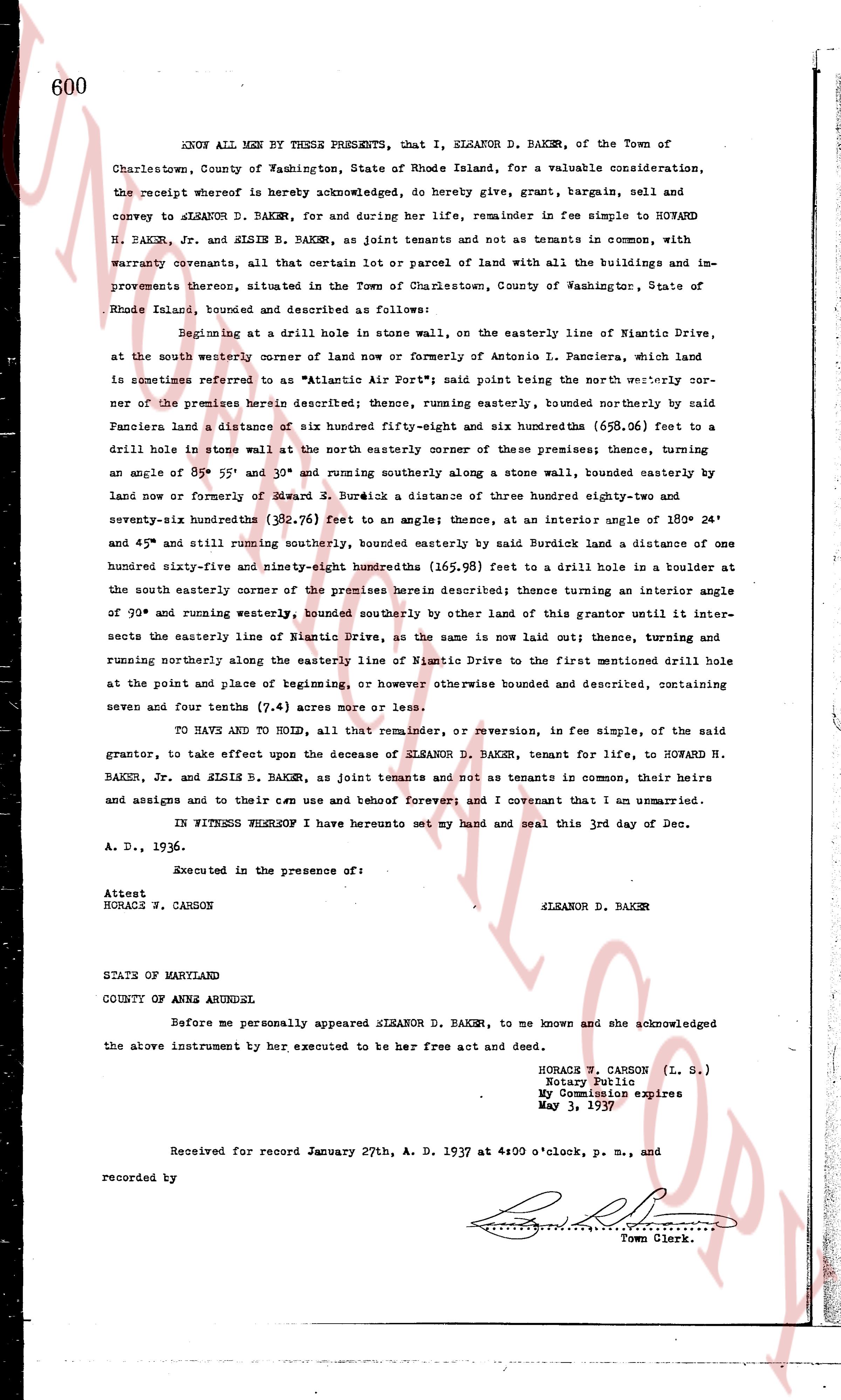
page 1

deed_walker_v1.9_2026-10-10 · the index is the town's own (i2l.uslandrecords.com); transcripts, chains and the assessor's cards are the Perry Machine's reading of it. Where the record we hold runs out, the page says so.