The instrument's own words
page 1 · read by Gemma vision
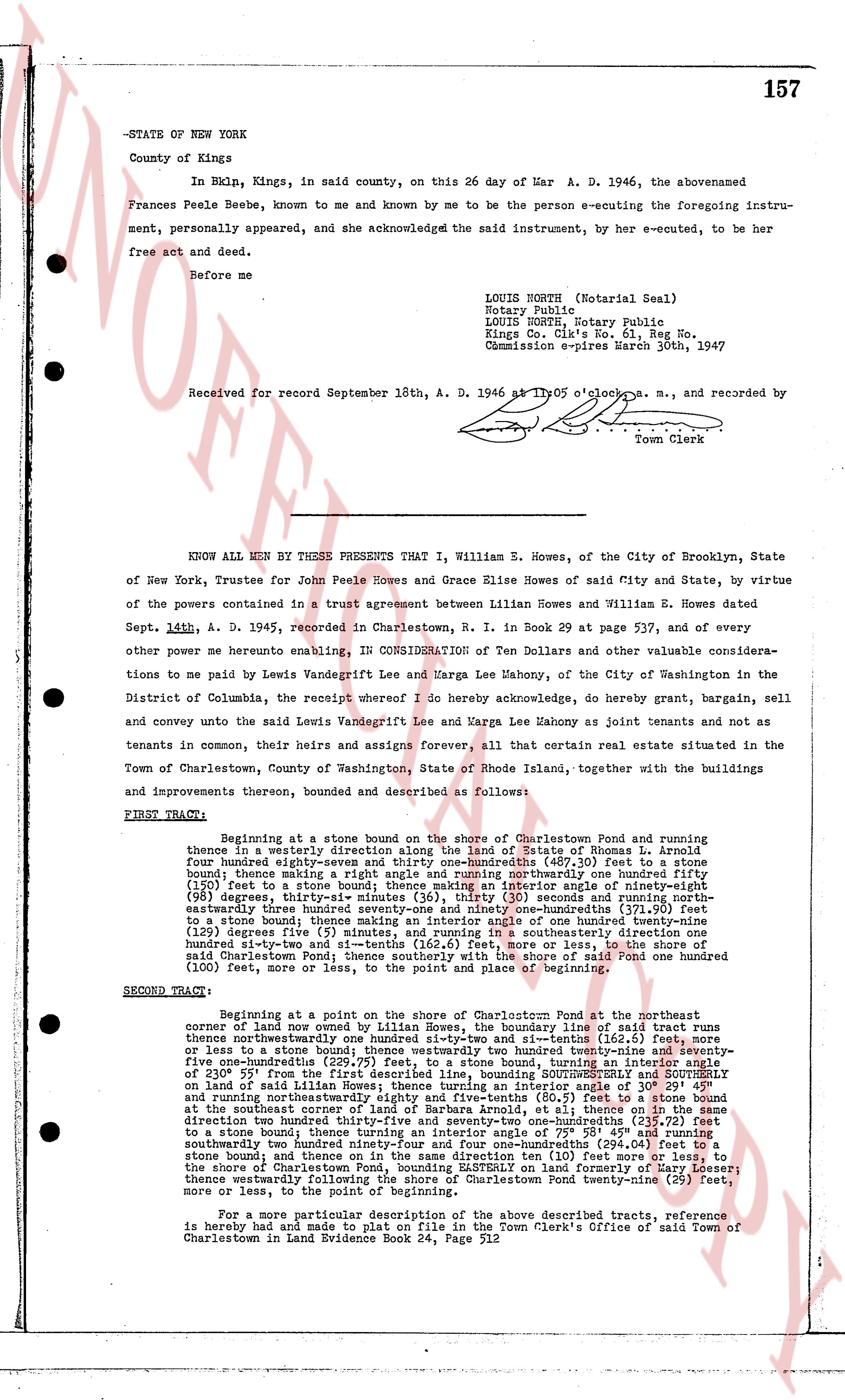
157
-STATE OF NEW YORK
County of Kings
In Bklyn, Kings, in said county, on this 26 day of War A. D. 1946, the abovenamed Frances Peele Beebe, known to me and known by me to be the person e-cuting the foregoing instrument, personally appeared, and she acknowledged the said instrument, by her e-cuted, to be her free act and deed.
Before me
LOUIS NORTH (Notarial Seal)
Notary Public
LOUIS NORTH, Notary Public
Kings Co. Clk's No. 61, Reg No.
Commission expires March 30th, 1947
Received for record September 18th, A. D. 1946 at 11 05 o'clock a. m., and recorded by
Town Clerk
KNOW ALL MEN BY THESE PRESENTS That I, William E Howes, of the City of Brooklyn, State of New York, Trustee for John Peele Howes and Grace Elise Howes of said City and State, by virtue of the powers contained in a trust agreement between Lillian Howes and William E. Howes dated Sept. 14th, A. D. 1945, recorded in Charlestown, R. I. in Book 29 on page 537, and of every other me powerne hereby enabling, IN CONSIDERATION of Ten Dollars and other valuable considerations to me paid by Lewis Vandegrift Lee and Marga Lee Mahony, of the City Washington in the District of Columbia, the receipt whereof I do hereby acknowledge, do hereby grant, bargain, sell and convey unto the said Lewis Vandegrift Lee and Marga Lee Mahony as joint tenants and not as tenants in common, their heirs and assigns forever, all that certain real estate situated in the Town of Charlestown, County of Washington, State of Rhode Island, together with the buildings and improvements thereon, bounded and described as follows:
FIRST TRACT:
Beginning at a stone bound on the shore of Charlestown Pond and running thence in a westerly direction on the line of Estate of Thomas L. Arnold about four hundred eighty-seven and thirty-one hundredths (487.30) feet to a stone bound; thence making a right angle and running northerly one hundred fifty (150) feet to a stone bound; thence making an interior angle of one hundred sixty-one (161) degrees, thirty-six minutes (36) seconds, thirty (30) seconds and running northeasterly three hundred seventy-one and forty-four hundredths (371.44) feet to a stone bound; thence making an interior angle of one hundred twenty-nine (129) degrees five (5) minutes (5) seconds and running southeasterly one hundred sixty-one and thirty-two (161.32) feet and si-twenty-six (16.26) feet, more or less, to the shore of said Charlestown Pond; thence southerly with the shore of said Pond one hundred twenty (120) feet, more or less, to the point of beginning.
SECOND TRACT:
Beginning at a point on the shore of Charlestown Pond at the Northeast corner of land now owned by Lillian Howes, the boundary line of said tract runs thence southeasterly one hundred twenty-three and si-twenty-six (123.26) feet, more or less to a stone bound; thence westerly two hundred twenty-nine and seventy-five one-hundredths (229.75) feet to a stone bound; thence running in an easterly direction on a bearing of 230° 55' from the first described line, bounding SOUTHEASTERLY AND SOUTHERLY on land of said Lillian Howes, then running southeasterly one hundred twenty-one (121) feet and running northeasterly eighty-eight and five-tenths (88.5) feet to a stone bound at the Northeast corner of land of said Lillian Howes; thence running in a northeasterly direction two hundred thirty-seven and seventy-two one-hundredths (237.72) feet to a stone bound; thence making an interior angle of 131° 45' and running southeasterly two hundred ninety-four and four one-hundredths (294.04) feet to a stone bound now marking the Northwest corner of land of (310) feet to a stone bound on the shore of Charlestown Pond, bounding EASTERLY on land formerly of Mary Loeser; thence westerly following the shore of Charlestown Pond twenty-nine (29) feet, more or less, to the point of beginning.
For a more particular description of the above described tracts, reference is hereby had and made to plat on file in the Town Clerk's Office of said Town of Charlestown in Land Evidence Book 24, Page 312
page 2 · read by Gemma vision
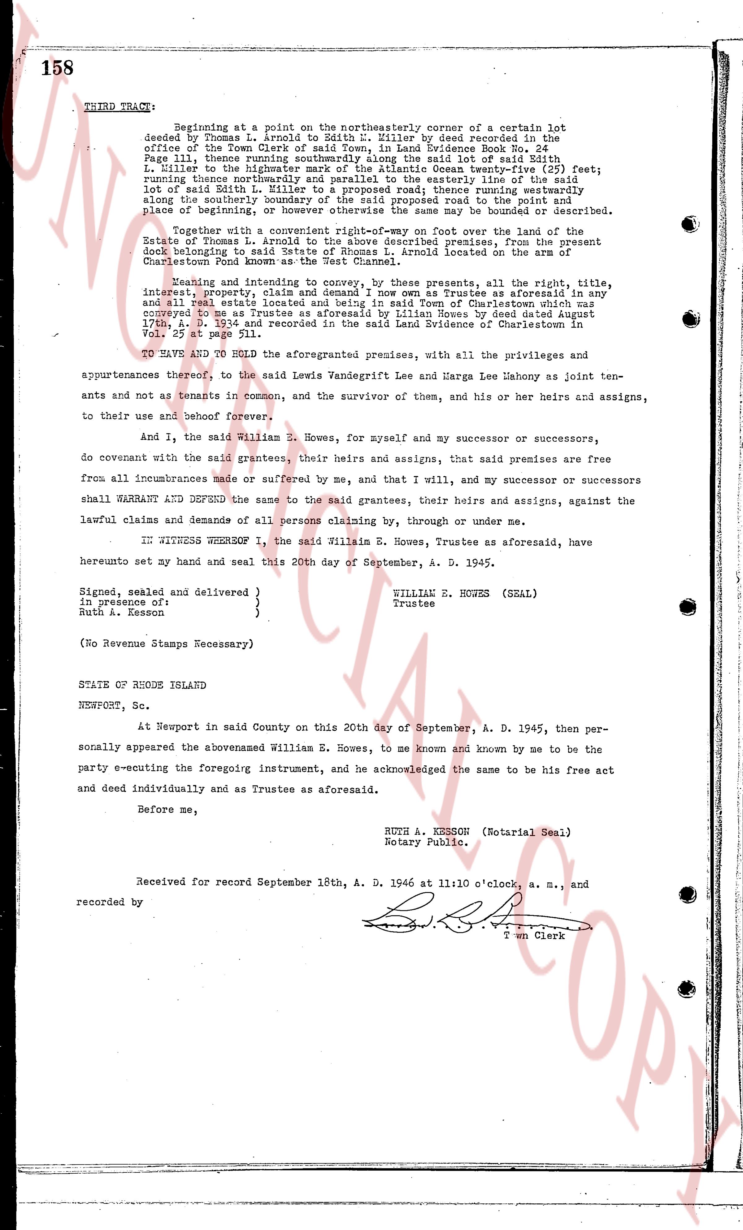
158
THIRD TRACE: Beginning at a point on the northeasterly corner of a certain lot deeded by Thomas L. Arnold to Edith H. Miller by deed recorded in the office of the Town Clerk of said Town, in Land Evidence Book No. 24 page 132 thence running easterly [?] degrees [?] minutes [?] seconds to the south east corner of said Edith H. Miller to the highwater mark of the Atlantic Ocean twenty-five (25) feet; running thence northerly and parallel to the easterly line of the said lot of said Edith H. Miller [?] degrees [?] minutes [?] seconds thence running northerly along the southerly boundary of the said proposed road to the point and place of beginning a line [?] degrees [?] minutes [?] seconds may be bounded or described.
Together with a convenient right-of-way one foot over the land of the State of Rhode Island to the above described premises, from the present dock belonging to said land, and the said right-of-way located on the area of Charlestown Pond known as the West Channel.
Meaning and intending to convey, by these presents, all the right, title, interest, property, claim and appurtenances of William E. Howes as Trustee as aforesaid in any and all real estate located and being in said Town of Charlestown which was conveyed to me as Trustee as aforesaid by Lillian Howes by deed dated August 17th, A. D. 1934 and recorded in the said Land Evidence of Charlestown in Vol. 25 at page 511.
TO HAVE AND TO HOLD the aforementioned premises, with all the privileges and appurtenances thereof, to the said Lewis Vandegrift Lee and Marga Lee Mahony as joint tenants and not to tenants in common, and the survivor of them, and his or her heirs and assigns, to their use and behoof forever.
And I, the said William E. Howes, for myself and my successor or successors, do covenant with the said grantees, their heirs and assigns, that said premises are free from all incumbrances made or suffered by me, and that I will, and my successor or successors shall WARRANT AND DEFEND the same to the said grantees, their heirs and assigns, against the lawful claims and demands of all persons claiming by, through or under me.
IN WITNESS WHEREOF I, the said William E. Howes, Trustee as aforesaid, have hereunto set my hand and seal this 20th day of September, A. D. 1945.
Signed, sealed and delivered }
in presence of } WILLIAM E. HOWES (SEAL)
Ruth A. Kesson } Trustee
(No Revenue Stamps Necessary)
STATE OF RHODE ISLAND
NEWPORT, Sc.
At Newport in said County on this 20th day of September, A. D. 1945, then personally appeared the abovementioned William E. Howes, to me known and known by me to be the party executing the foregoing instrument, and he acknowledged the same to be his free act and deed individually and as Trustee as aforesaid.
Before me,
RUTH A. KESSON (Notarial Seal)
Notary Public.
Received for record September 18th, A. D. 1946 at 11:10 o'clock, a. m., and recorded by
[Signature]
Town Clerk
The page as recorded