The Deed Walker · From Ninigret · Charlestown, Rhode Island land evidence, 1738 to today
Trail: 13675 › 13380 › 12950

12/19/1778 · AGREEMENT · book 3 page 277 doc 12950

From LEWIS DAVID life, KINYON NATHAN
To KINYON NATHAN, LEWIS DAVID life
Premises none · Lots of North March & edge Lodge Land (Charlestown, Salt Pond, Dead Hope Cove)
Also on this page: WILL DAVIS JEDEDIAH

Back — where this land came from

This instrument states no source of title that we have read yet.

The grantor's earlier acquisitions, by name — the man, not necessarily this land

◀ 1778 · DEED · GRINELL DARHISS; GRINELL STEPHEN → KINYON NATHAN · book 3 p 263
◀ 1777 · DEED · CROSS JOSEPH; CROSS ABIGAIL → KINYON NATHAN · book 3 p 245
◀ 1777 · DEED · ROBINSON MATTHEW → KINYON NATHAN · book 3 p 246
◀ 1776 · DEED · NARRAGANSETT INDIAN TRIBE; COLONY OF RHODE ISLAND & PROVIDENCE PLANTAT → KINYON NATHAN · book 3 p 215
◀ 1773 · DEED · CHURCH CHARLES; CHURCH SUSANNAH → KINYON NATHAN · book 3 p 103
◀ 1772 · DEED · KINYON MARY; KINYON THOMAS → KINYON NATHAN · book 3 p 100
◀ 1771 · MORTGAGE · POTTER WILLIAM; POTTER SARAH → KINYON NATHAN · book 3 p 45
◀ 1769 · DEED · SAUNDERS LYDIA; SAUNDERS STEPHEN → KINYON NATHAN · book 2 p 411
◀ 1769 · DEED · WELLS JAMES; WELLS RUTH → KINYON NATHAN · book 2 p 412
◀ 1768 · DEED · TUCKER JOHN; TUCKER ELISABETH → KINYON NATHAN · book 2 p 362
◀ 1766 · DEED · KINYON MARY; KINYON JONATHAN → KINYON NATHAN · book 2 p 271
◀ 1756 · DEED · KINYON JONATHAN → KINYON NATHAN · book 1 p 356
◀ 1741 · DEED · UNDERWOOD JOHN → LEWIS DAVID · book 1 p 51
◀ 1739 · DEED · KNOWLES ANN; KNOWLES ROBART → SAUNDERS EDWARD; LEWIS DAVID; BURDICK THOMAS · book 1 p 30

Forward — where this land went

Follow forward ▶ 1884 · DEED · CONE EDWARD S; CONE MARY → BROWNELL HENRIETTA H · book 11 p 279
“deed of the same premises from the said Elizabeth Brunos & Ann Nelson to this grant”
cites this instrument as its source · read by gemma
Follow forward ▶ 1884 · DEED · CONE EDWARD S; CONE MARY → BROWNELL HENRIETTA H · book 11 p 279
“deed of the same premises from the said Elizabeth Brunos & Ann Nelson to this grant”
cites this instrument as its source · read by gemma

The grantee's later conveyances, by name — the man, not necessarily this land; the one that cites this deed as its source is the land

▶ 1785 · DEED · KINYON NATHAN; KINYON SAMUEL; KINYON BENJAMIN → KINYON JOSHU · book 3 p 454
▶ 1785 · DEED · KINYON MARY; KINYON NATHAN → LEWIS PELEG · book 3 p 459
▶ 1786 · DEED · KINYON NATHAN → KINYON GARDNER · book 3 p 493
▶ 1789 · DEED · KINYON NATHAN → GRINNEL STEPHEN · book 3 p 570
▶ 1790 · DEED · KINYON MARY; KINYON NATHAN → PERKINS ELISABETH · book 3 p 571
▶ 1798 · DEED · KINYON NATHAN → STREAMBACK THOMAS · book 4 p 244
▶ 1798 · DEED · KINYON NATHAN → CHARLESTOWN TOWN OF · book 4 p 250
▶ 1798 · DEED · KINYON NATHAN → KINYON JAMES · book 4 p 251
▶ 1800 · DEED · KINYON NATHAN → KINYON JAMES · book 4 p 277
▶ 1806 · DEED · KINYON NATHAN → BOSS JOSHUA · book 4 p 473
▶ 1811 · LEASE · KINYON JAMES; KINYON NATHAN → KINYON NATHAN; KINYON JAMES · book 5 p 16

The instrument's own words

page 1
277 To all People to whom these Presents shall come Greeting Knows that whereas we David Lewis of westerly in Kings County Yeoman and Nathan Hinson of Stephenhen in the County above Yeoman being each of us Owner of a Lot of North March & edge Lodge Land lying in Charlestown in the County above in the State of Rhode Island beyond the Slates on the North side of the Salt Pond, in which Lot being bounded on each side's Lot, at the South end of a Cove, commonly called the Date, Dead Hope Cove, & Lewis's Lot on the West and s. Hinson's Lot on the East throughout and as time was a Breach made from some Days past from the Cove through the Reach into the Sea, whereas since s. Lands did join, the running of the Water has carried away the bank between our s. Lands, and at last, and removed some of the Land a dont s. Cove, and between our s. Lands & Cove a considerable part of Land, which has become a Salt Marsh also now into s. Cove a considerable part of Land, which has become a Salt Marsh So that the Dividing Line between our s. Lands became unknown Therefore in order to settle the Line between our s. Lands for our Peace, Comfort and Avoidance of future Quarrels we have agreed and entered into a Firm Pact on the Reach a little to the Northward of the South end of s. Dead Hope Cove, and agree to run from there about North 26 the Degrees West a Straight Line through s. Dead Hope Cove and edge Lodge toward a small Corner Timber in the West Part of the Salt Marsh the Lot Distinguishable Plain and void to live in, until it comes to the Main Salt Pond to the Northward of s. edge Lodge. All we have agreed that s. Line is and shall be the Dividing Line between our s. Lands; that is to say it is the East Line of s. David Lewis's Land, and the West Line of s. Nathan Hinson's Lands & All which Line we the s. David Lewis, and Nathan Hinson do agree and attest it to be the Dividing Line between our above s. Lands in Consideration whereof our we have hereunto set our Hands and affixed our Seals the Twentieth Day of September AD 1779. Signed and Sealed in Presence of Joseph Marvson Peter Marvson David Lewis L.S. Nathan Hinson L.S. September 20th AD 1779 before the Subscribers Mr David Lewis, and Mr Nathan Hinson personally appeared in westerly and acknowledged this Instrument to be their Act and Deed Had & Seal By Joseph Marvson Justice Peace The foregoing Instrument was recorded Dy 20 1779 By the Longdon & Toth In the Name of God, Amin This Twenty fourth Day of January, in the Year of Our Lord One thousand Seven hundred and Seventy Seven, I Joseph Davis of Stephenhen, in Kings County, and State or Government of Rhode Island, Yeoman being Sick, and in a very poor State of Health but of sound and composed Mind and memory, thanks be given to Mighty God for the Same, and calling to Mind the mortality of my Body, knowing that all

The page as recorded
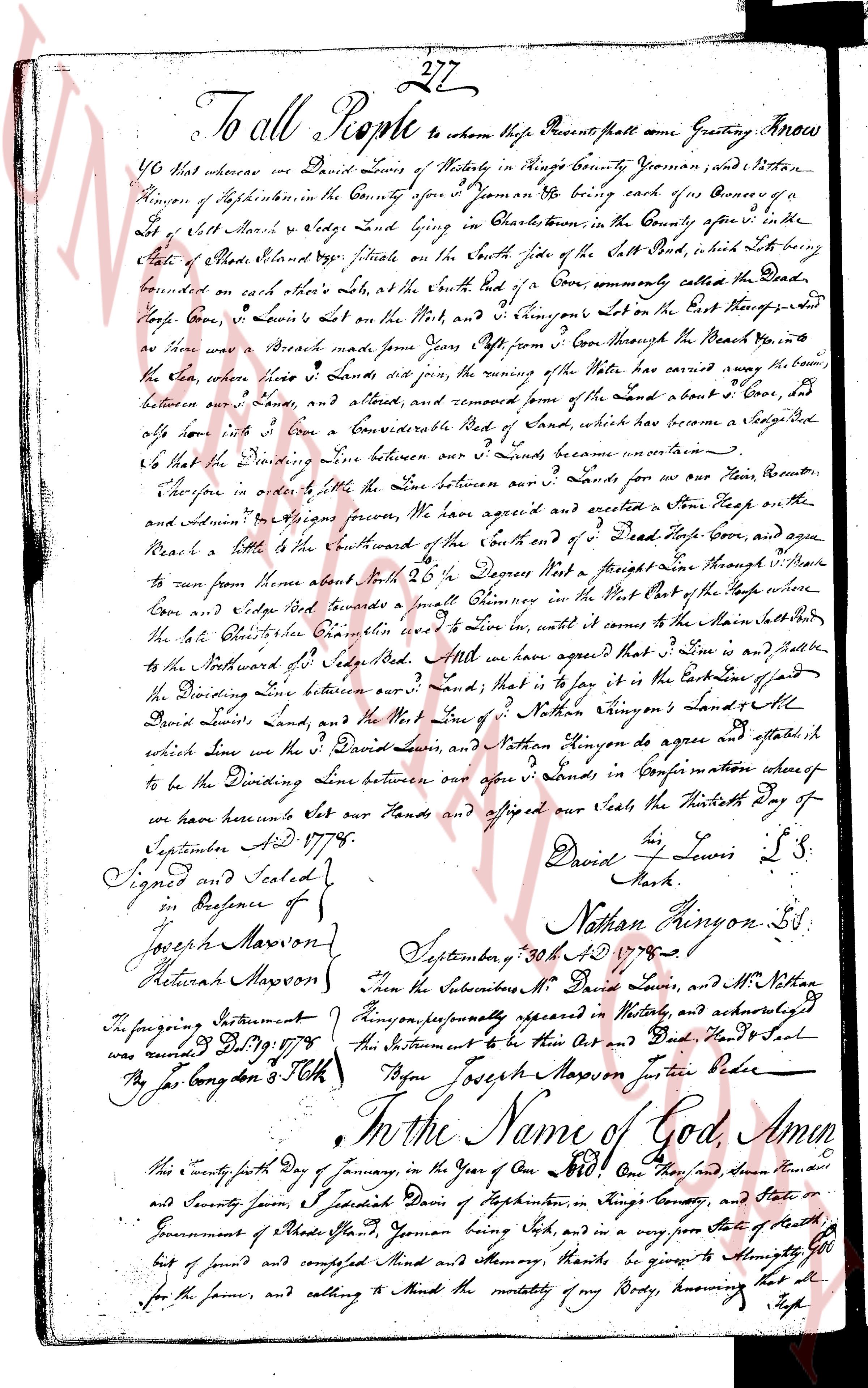
page 1

deed_walker_v1.9_2026-10-10 · the index is the town's own (i2l.uslandrecords.com); transcripts, chains and the assessor's cards are the Perry Machine's reading of it. Where the record we hold runs out, the page says so.