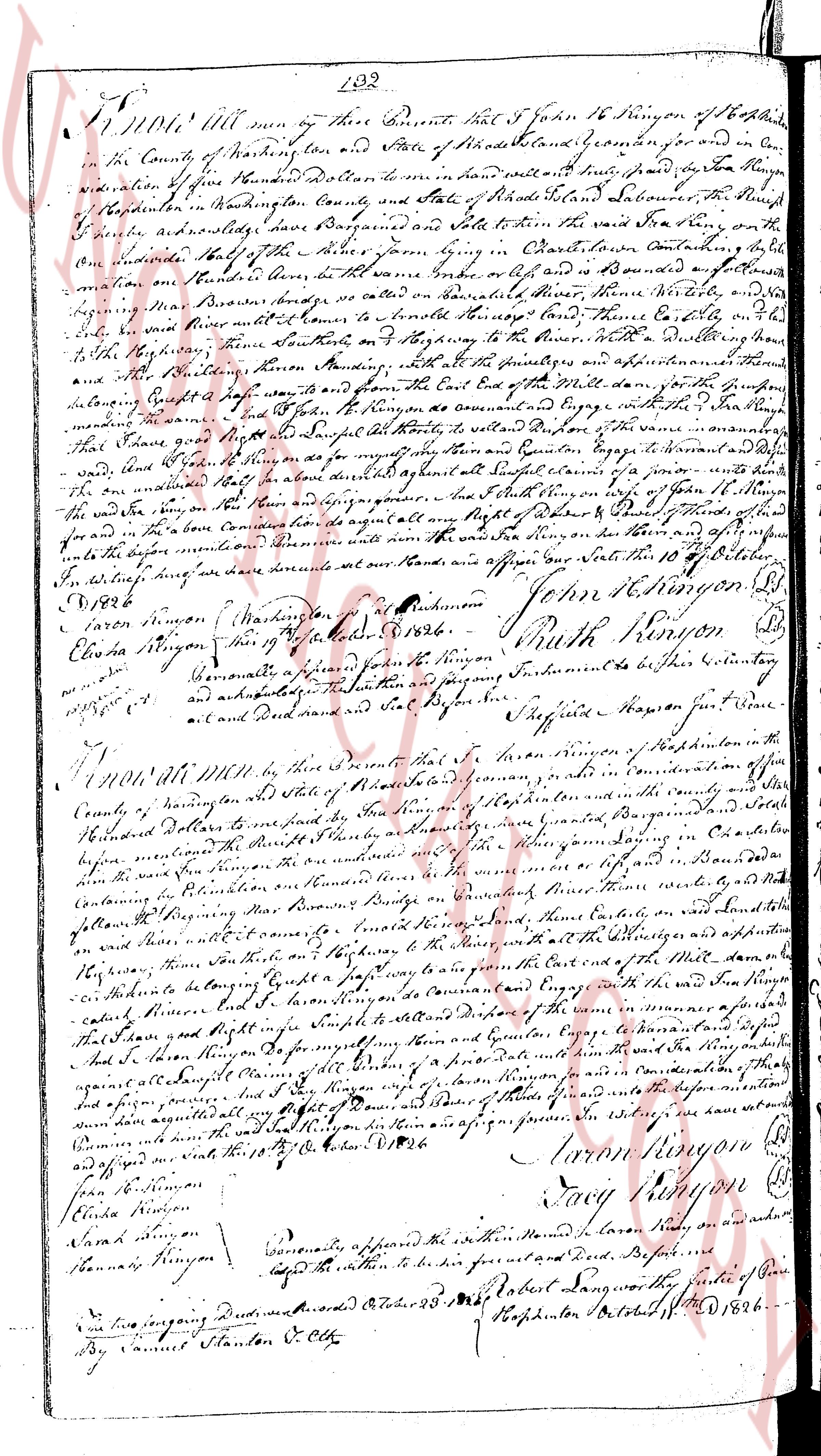
The instrument's own words
page 1
132
KNOW ALL men by these Presents that I John 16 Rynson of Hopkinton
in the County of Washington town and State of Rhode Island sc situated for and in con-
sideration of Five hundred Dollars to me paid in hand well and truly paid by the Hon Rynson
of Hopkinton in Washington County State of Rhode Island aforesaid the Purchaser
of the premises acknowledge and sell to the said Hon Rynson the said land sitting on the
one side with the [illegible] of the house form lying in Charles Lane containing full
measure on the North side to be the water name Oboke or as is known and described a
location on the North side to be water name Oboke river shore North side till it
be the water river Brown's bridge to be water name Oboke river shore North side till it
be the water river and come to Honest's bridge North side then Eastly on the
to the Hopkinton town South side on the [illegible] to the house with a dwelling house
and all the buildings thereon Standing with all the privileges and appurtenances there
belonging Exhibit a map part of and going East the East End of the water land for the purpose
of the premises and I John 16 Rynson do covenant and agree with the said Hon Rynson
binding me and my heirs Legal heirs to warrant to defend the said premises
that said land good right title in law for myself and my heirs and successors Legal heirs to possess and
void the land forever and that he shall always be quiet against all and lawful claims of a person whom
whatsoever in the world and that no other person than the aforesaid John 16 Rynson of Hopkinton
the said land then on the then and there signed and sealed the day and year first above written
and in the form contained in the said deed only of Right and Title of Rhode Island state
unto the before mentioned premises until the said Hon Rynson be then and there of sufficient
to witness during our lives done written on our hands and appose our seals this 10th of October
1826
John 16 Rynson [seal]
Aaron Rynson Washington pr. Attachment
Eliza Rynson this 10th of October 1826. Ruth Rynson [seal]
Personally appeared a few persons in the foreground’s acknowledgment to be their signature
and acknowledged the Instrument to be their signature
and deed done and sealed in my presence. Stephen Mason Just. of the Peace.
KNOW ALL MEN by these Presents that I Aaron Rynson of Hopkinton in the
County of Washington state of Rhode Island sc in consideration of one
hundred Dollars to me paid by the said Hon Rynson of Hopkinton and in the county and state
aforesaid before the mentioned the above mentioned the said Hon Rynson coming in a certain lot
containing the said land form on the North side to be the water name Oboke river shore North side
containing the said premises on North side on Oboke river shore North side till it
follow the river Beginning on Oboke river shore North side there westerly to the
on said water till it come to Honest's bridge North side then Eastly on the
to the Hopkinton town South side on the [illegible] with all the privileges and appurtenances
there belonging Exhibit a map part of and going East the East End of the water land for the purpose
of the premises and I Aaron Rynson agree to be in Command and agree with the said Hon Rynson
binding me and my heirs Legal heirs to warrant to defend the same in a manner aforesaid
that I have good right title in law for myself and my heirs and successors Legal heirs to possess and
void the land forever and that he shall always be quiet against all and lawful claims of all persons of a person whom whatsoever in the world
and that no other person than the aforesaid Aaron Rynson in consideration of the department
and assigned all my right and title of the said land to the said Hon Rynson in as sign and possess
their him the said land then on the then and there signed and sealed the day and year first above written
and appose our seals this 10th of October 1826
Aaron Rynson [seal]
Jean Rynson
Eliza Rynson
Nancy Rynson [seal]
Sarah Rynson
Hannah Rynson
Personally appeared the within named persons on an oath and upon
which led the within to be their signature and deed Before me
Robert Lang worthy the Clerk of Court
two foregoing Deeds were recorded October 23 1826 Hopkinton October 23 1826
By Samuel Stanton C. Clk
The page as recorded