The Deed Walker · From Ninigret · Charlestown, Rhode Island land evidence, 1738 to today
Trail: 5565 › 267@27/182 › 1226@29/671

3/18/1946 · DEED · book 29 page 671 doc 1226@29/671

From WILSON GRAFTON M life, WILSON MARION G
To HOXSIE ANNA M life, HOXSIE EVERETT A life
Consideration consideration paid
Premises none · Tract with buildings bounded by barn foundation and Narrow Lane (Charlestown, Narrow Lane)
Index description SEE INSTRUMENT

Back — where this land came from

deed Dorothy Beals MacPherson book 29 p 507 Charlestown
“conveyed to these Grantors by deed from Dorothy Beals MacPherson”
◀ Follow back 1946 · RELEASE · INDUSTRIAL TRUST CO → WEST DOROTHY A; WEST EARL R · book 29 p 507
read by: gemma

The grantor's earlier acquisitions, by name — the man, not necessarily this land

◀ 1945 · DEED · BEALS DAISY H EST; MACPHERSON DOROTHY BEALS EX → WILSON GRAFTON M; WILSON MARION G · book 29 p 509
◀ 1946 · MORTGAGE · RUSSELL CLAYTON E; RUSSELL FRANCES L → WILSON GRAFTON M; WILSON MARION G · book 30 p 188
◀ 1945 · MORTGAGE DISCHARGE · INDUSTRIAL TRUST CO → WILSON GRAFTON M; WILSON MARION G · book 25 p 12
◀ 1945 · RELEASE · WHITTEMORE DAISY S → WILSON GRAFTON M; WILSON MARION G · book 29 p 510
◀ 1944 · MORTGAGE DISCHARGE · DISASTER LOAN CORPORATION → WILSON GRAFTON M; WILSON MARION G · book 29 p 240
◀ 1941 · MORTGAGE DISCHARGE · INDUSTRIAL TRUST COMPANY → WILSON GRAFTON M; WILSON MARION G · book 28 p 150
◀ 1939 · DEED · INDUSTRIAL TRUST COMPANY → WILSON GRAFTON M; WILSON MARION G · book 28 p 40
◀ 1939 · DEED · OPIE DAISY S → WILSON GRAFTON M; WILSON MARION G · book 28 p 41
◀ 1939 · DEED · INDUSTRIAL TRUST COMPANY → WILSON GRAFTON M; WILSON MARION G · book 28 p 91
◀ 1939 · DEED · GREENE ANNIE M; GREENE GEORGE W; WILSON GRAFTON M; WILSON MARION G; GR → WILSON MARION G; WILSON GRAFTON M · book 27 p 535
◀ 1939 · DEED · GREENE SAMUEL S → WILSON GRAFTON M; WILSON MARION G · book 27 p 536
◀ 1939 · DEED · GREENE SAMUEL S → WILSON GRAFTON M; WILSON MARION G · book 27 p 537
◀ 1939 · ORDER · WILSON GRAFTON M; WILSON MARION G; GREENE SAMUEL S → GREENE SAMUEL S; WILSON MARION G; WILSON GRAFTON M · book 27 p 672
◀ 1938 · DEED · WAKEFIELD TRUST COMPANY → WILSON GRAFTON M · book 27 p 331

Forward — where this land went

The grantee's later conveyances, by name — the man, not necessarily this land; the one that cites this deed as its source is the land

▶ 1947 · DEED · HOXSIE ANNA M; HOXSIE EVERETT A → MADISON EVELYN H · book 30 p 485
▶ 1959 · DEED · HOXSIE EVERETT A; MADISON EVELYN H; MADISON STANLEY V → PEARCE NORMA M; PEARCE ROBERT E · book 36 p 659
▶ 1967 · DEED · HOXSIE EVERETT; MADISON EVELYN A H; MADISON STANLEY V → SCHIRRMACHER LILA F · book 41 p 422
▶ 1969 · DEED · HOXSIE EVERETT A; HOXSIE MARTHA E → RICHARD CARL M · book 43 p 257
▶ 1954 · MORTGAGE · HOXSIE EVERETT A; MADISON EVELYN H → WASHINGTON TRUST COMPANY · book 34 p 366
▶ 1956 · MORTGAGE · HOXSIE EVERETT A; MADISON EVELYN H → WASHINGTON TRUST COMPANY · book 35 p 251
▶ 1959 · MORTGAGE · HOXSIE EVERETT A; MADISON EVELYN H → WASHINGTON TRUST COMPANY · book 36 p 502

The instrument's own words

page 1 · read by Gemma vision
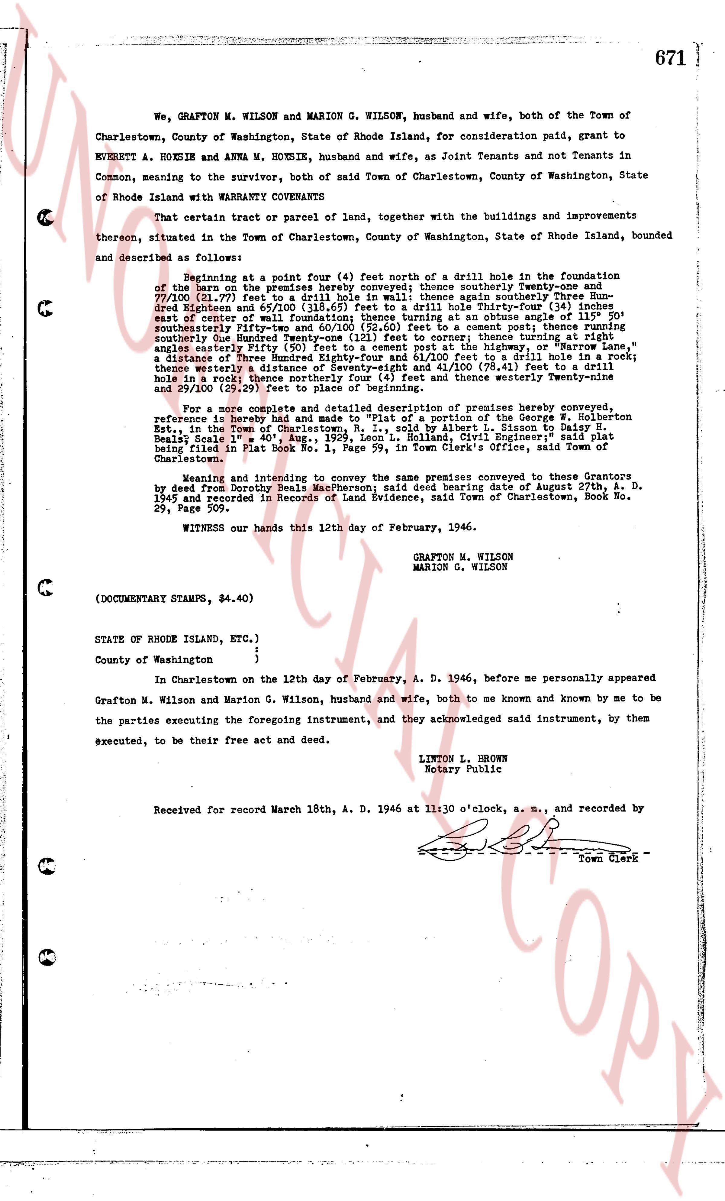
671 We, GRAFTON M. WILSON and MARION G. WILSON, husband and wife, both of the Town of Charlestown, County of Washington, State of Rhode Island, for consideration paid, grant to EVERETT A. HOXSIE and ANNA M. HOXSIE, husband and wife, as Joint Tenants and not Tenants in Common, meaning to sever the unity, both of said Town of Charlestown, County of Washington, State of Rhode Island with WARRANTY COVENANTS That certain tract or parcel of land, together with the buildings and improvements thereon, situated in the Town of Charlestown, County of Washington, State of Rhode Island, bounded and described as follows: Beginning at a point four (4) feet north of a drill hole in the foundation of the barn on the premises hereby conveyed; thence southerly Twenty-one and 71/100 (21.71) feet to a drill hole in wall; thence again southerly Three Hundred Eighteen and 55/100 (318.55) feet to a drill hole; thence easterly Sixty-four and 11/100 (64.11) feet east of centerline of wall foundation; thence turning at an obtuse angle of 115° 50' southeasterly Fifty-two and 50/100 (52.50) feet to a cement post; thence running southeasterly One hundred Twenty-four and 11/100 (124.11) feet; thence turning at an obtuse angle easterly Fifty (50) feet to a cement post at the highway, or "Narrow Lane," a distance of Three Hundred Twenty-four and 11/100 (324.11) feet from the drill hole; thence westerly a distance of Seventy-eight and 41/100 (78.41) feet to a drill hole in a rock fence; thence running northwesterly Twenty-nine and 29/100 (29.29) feet to place of beginning. For a more complete and detailed description of premises hereby conveyed reference is hereby had to a deed conveying a portion of the George W. Holbertson Est., in the Town of Charlestown, R.I., sold by Albert L. Sisson to Daisy H. Beattie's Heirs 601.4 acres, more or less, said deed being filed in Plat Book No. 1, Page 59, in Town Clerk's Office, said Town of Charlestown. Knowing and intending to convey the same premises conveyed to these Grantors by deed from Dorothy Beals MacPherson; said deed bearing date of August 27th, A. D. 1945 and recorded in Records of Land Evidence, said Town of Charlestown, Book No. 29, Page 507. WITNESS our hands this 12th day of February, 1946. GRAFTON M. WILSON MARION G. WILSON (DOCUMENTARY STAMPS, $4.40) STATE OF RHODE ISLAND, ETC.) County of Washington ) ) In Charlestown on the 12th day of February, A. D. 1946, before me personally appeared Grafton M. Wilson and Marion G. Wilson, husband and wife, both to me known and known by me to be the parties executing the foregoing instrument, and they acknowledged said instrument, by them executed, to be their free act and deed. LINTON L. BROWN Notary Public Received for record March 18th, A. D. 1946 at 11:30 o'clock, a. m., and recorded by [?] Town Clerk

The page as recorded
page 1

deed_walker_v1.9_2026-10-10 · the index is the town's own (i2l.uslandrecords.com); transcripts, chains and the assessor's cards are the Perry Machine's reading of it. Where the record we hold runs out, the page says so.