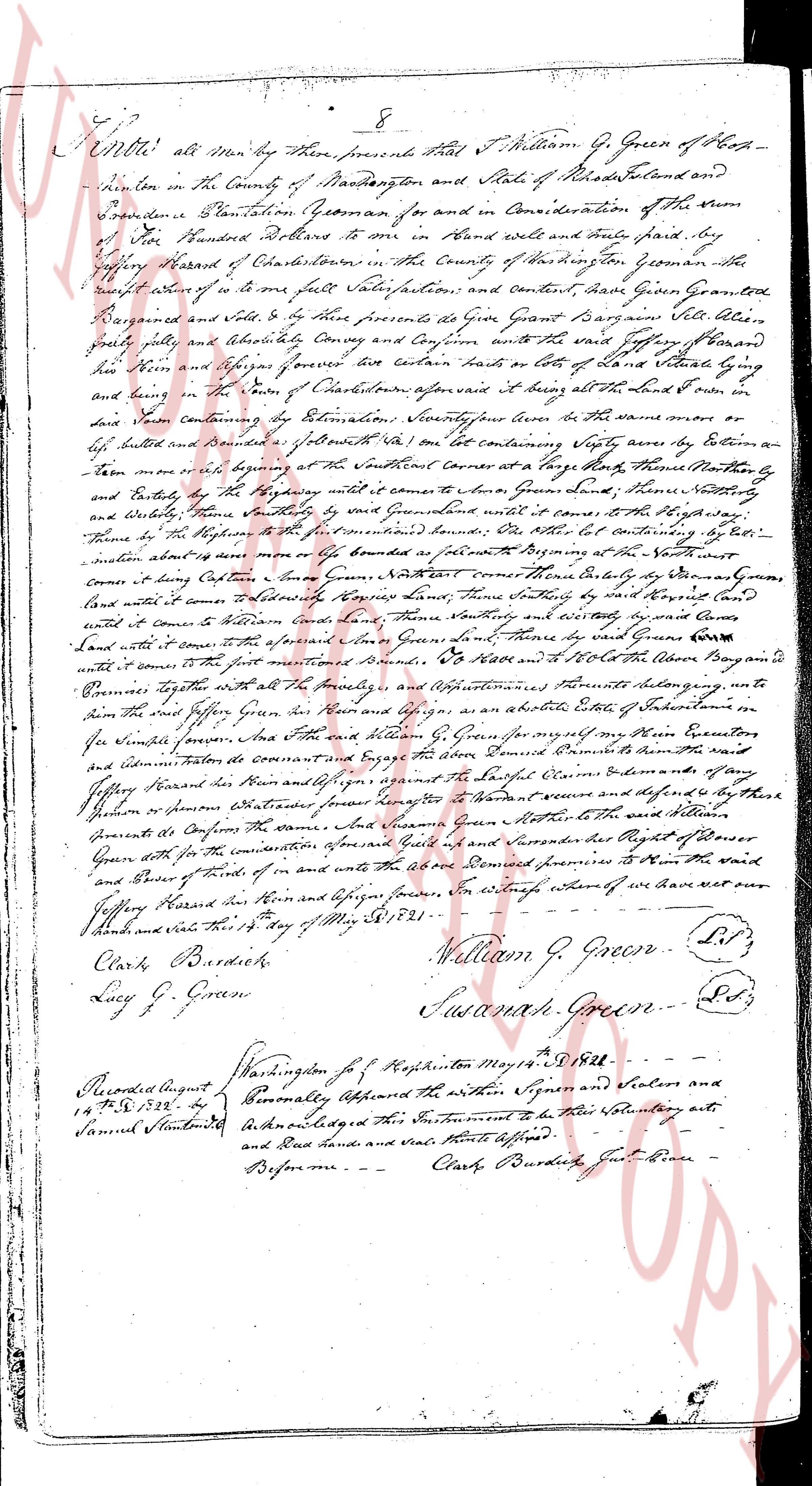
The instrument's own words
page 1
Know all Men by these presents That I William G. Green of Hop-
kinton in the County of Washington and State of Rhode Island and
Providence Plantations Yeoman for and in Consideration of the Sum
of One Hundred Dollars to me in Hand well and truly paid by
Jeffrey Hazard of Charlestown in the County of Washington the a-
foreset witness to me the full Sale Satisfaction and Convent and Cause Given Granted
Bargained and Sold to be Heirs presents do Give Grant Bargain Sell Alien
Grant fully and Absolutely Convey and Confirm unto the said Jeffrey Hazard
his Heirs and Assigns forever five hundred acres of Lots of Land situate lying and
being in the town of Charlestown aforesaid age being all the land in the North r
land known containing by Estimation Seventeen acres the same more or
less bounded and bounded as follows with one lot containing Sixty acres by Eastern a-
ten more or less abutting at the Northeast Corner at a large Rock near Thomas Norton's
and Easterly by the Highway until it comes to the land of John Green Senior then Southerly
and Westerly then Southerly until it comes to the Highway then North to the High Way
then by the Highway to the Northeast Corner of the said lot the other lot containing by Esti-
mation about ten acres more or less bounded as follows Beginning at the North
Corner coming down Easterly some Rods to the Northwest corner bounded Easterly by the Damond
land until it comes to the Northeast corner land then Southerly until it comes to the North East
land until it comes to William Case's land then Southerly and easterly by said Case's
land until it comes to the land of John Green Senior then Southerly by said Green's
land until it comes to the first mentioned boundary To Have and to Hold the above described
premises together with all the Hereditaments and Appurtenances thereunto belonging unto
him the said Jeffrey Hazard his Heirs and Assigns as an absolute Estate of Inheritance in
fee Simple forever and that the said William G. Green for himself his Heirs Executors
and administrators do covenant and agree that the above named Demisee is lawfully Seised of the said
premises toward his Heirs and Assigns warrant the Right Quiet Claims Demands or any
person or persons whatsoever forever against the World secure and defended by the said
Grantor to Defend and Confirm the same both Lawfully Green Mother to the said William
Green with all the consideration of for and in and unto the above Demised premises to them the said
and heirs of funds of in the witness whereof we have set our
hands and seals this 15th day of May AD 1821. William G. Green. L.S.
Clark Burdick.
Lucy G. Green. Susannah Green. L.S.
Recorded August 14th 1832 by
Samuel Sturtevant
Washington for Hopkinton May 14th 1828
Personally appeared the within Signers and declared and
acknowledged this Instrument to be their Voluntary acts
and Deed hands and Seal thereto affixed
Before me
Clark Burdick Justice of the Peace
The page as recorded