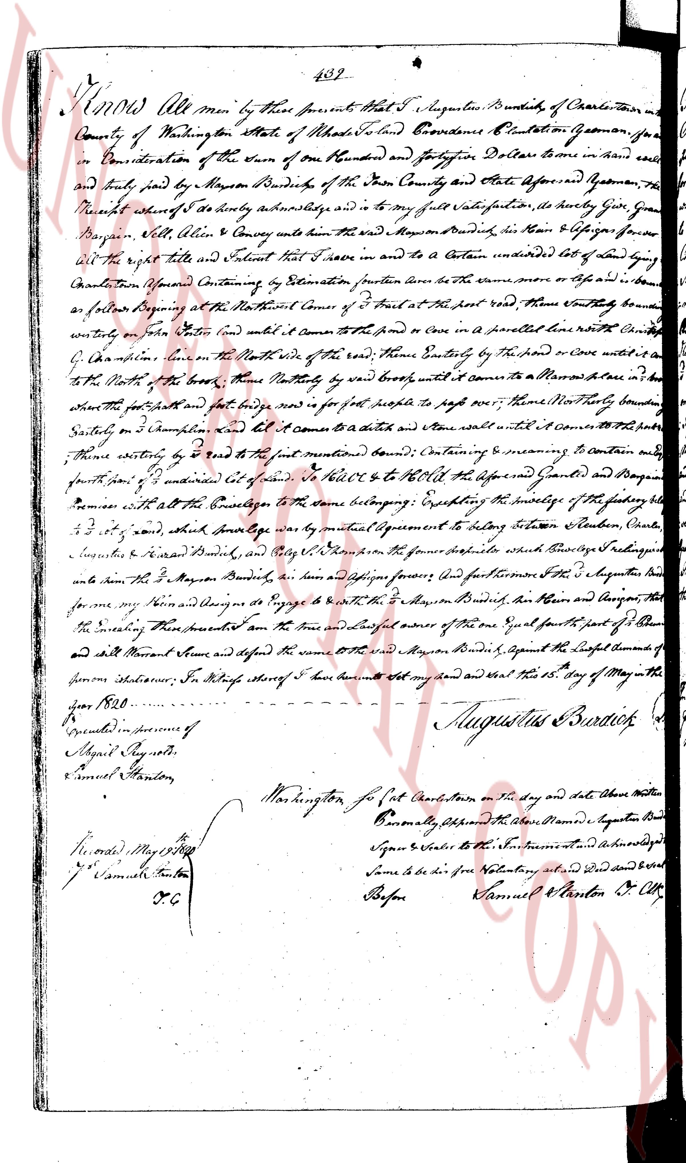
The instrument's own words
page 1
439
Know All men by these presents That I Augustinus Burdick of Charlestown in the
County of Washington State of Rhode Island Conveyance Providence Plantation Yeoman for
and in Consideration of the sum of one Hundred and Seventy Five Dollars to me in hand paid
and paid by Mayon Burdick of the Fore County and State aforesaid and Whereas the
Receipt whereof I do hereby acknowledge and to my full satisfaction hereby Give Grant
Bargain Sell Alien Alien & Convey unto the said Mayon Burdick, his Heirs & assigns forever
All the right title full Interest that I have in & to A Certain undivided lot of Land lying
Charlestown aforesaid Containing by Estimation fourteen rods in the west or east or in both
as follows Beginning at the North West corner of Three rods at the first rod West thence Boundly south
fourteen rods (East line) until it comes to the road or comes to a fence line with a stone Corner
(East line) then East on the North side of the road Then Easterly by the road or over a ditch to
the North of the North of the North West line Namely by West until it comes to Mayons fence in the North
where the foot path and foot bridge road is for people to pass over Thence North Boundly
Easterly on 3 [illegible] until it comes to a ditch and stone wall until it comes Over the property
Thence easterly to road (to the first mentioned) bound Containing & measuring to contain and
fourteen rods (West line) undivided lot of land To Have & To Hold the aforesaid Grant & Bargain
Premises with all the Conveyance to the same belonging Excepting the usage of the festering hole
4.5 [illegible] rods, and about Average way by mutual agreement to enter Station Station, [illegible]
Augustinus & Mayon Burdick, and any other Persons who shall hereafter be indulging
unto them the said Mayon Burdick, his Heirs and assigns forever and Furthermore I the Augustinus Burdick
for me my Heirs and assigns do Engage to be with the said Mayon Burdick, his Heirs and assigns the
the enclosing These presents I am the true and lawful owner of the one Equal fourth part of them
and shall warrant Issue and defend the same to the said Mayon Burdick against the lawful demands of
person whatsoever In Witness whereof I have done set my hand and seal this 15 day of May in the
year 1820.
Augustinus Burdick [seal]
Executed in presence of
Miguel Raynote
Samuel Stanton
Washington for Sot Charlestown on the day and date above written
Personally Appeared the above Named Augustinus Burdick
Signed & Sealed the Instrument and acknowledged
Same to be his free act and deed and seal
Before
Samuel Stanton Jr Clrk
Recorded May 15 1820
by Samuel Stanton
C C
The page as recorded