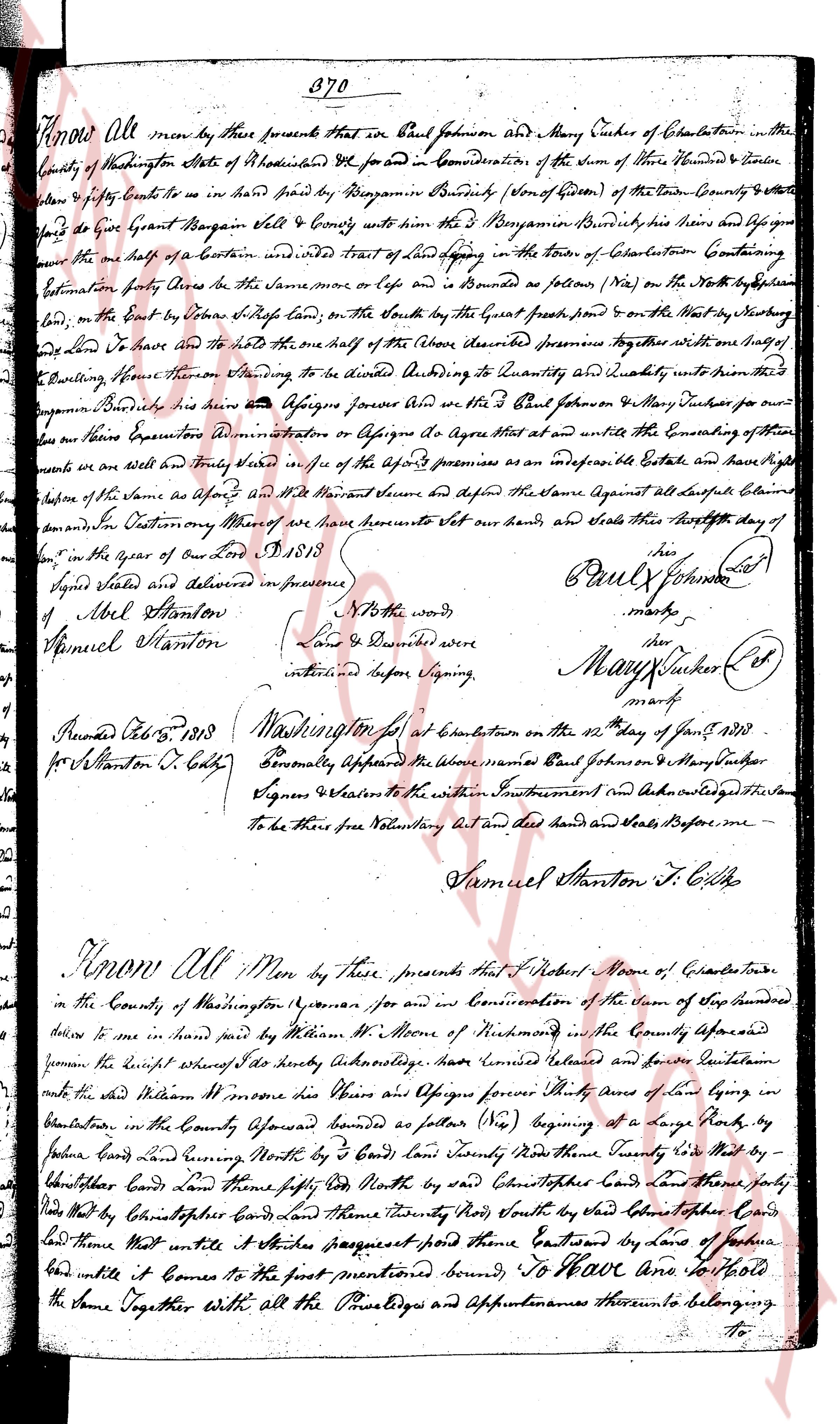
The instrument's own words
page 1
370
Know All men by these presents That we Paul Johnson and Mary Cutler of Charlestown in the
County of Washington State of Rhode Island Etc do for and in Consideration of the sum of Three Hundred & Twelve
pounds & six shillings Cash to us in hand paid by Benjamin Benedict (son of Gideon) of the said County & State
do give Grant Bargain sell & Convey with all the rights of the said Benjamin Benedict his heirs and assigns forever
unto the one half of Certain undivided Tract of Land lying in the Town of Charlestown Containing
Estimation forty Acres be it the Same way or lot or bounds as follows (viz) on the North by the [illegible]
land, on the East by the Steven White land; on the South by the Grant’s great pond & on the West by the [illegible]
land Do have and to have and to hold the one half of the (above described premises together with one half of
the Dwelling house thereon Standing to be divided According to Quantity and Quality between the said
Benjamin Benedict his heirs his assigns forever and us the said Paul Johnson & Mary Cutler for our
own heirs Assigns Administration or Assigns agree that we shall entitle the Enjoyment of their
premises as we are all and Truly Seised unity of the said Premises as an immediate Fee Estate and have agreed
before the presence of the same as Agent and Witness and Secure us against all lawful Claims
and Demands Outcoming Whereas of our here Hereunto Set our hands, and Seals This thirtieth day of
June in the year of our Lord 1813.
Signed Sealed and delivered in presence
of Abel Stanton
Samuel Stanton
To the words
Lands & Described were
interlined before Signing
Paul Johnson (L.S)
mark
Mary Cutler (L.S)
mark
Recorded Dec. 12th 1813
for Stanton C. S. C. L.
Washington for at Charlestown on the 12th day of Dec. 1813
Personally Appeared the above named Paul Johnson & Mary Cutler
Signers & Witness to the within Instrument and Acknowledged the Same
to be their free Voluntary Act and did hands and Seals before me
Samuel Stanton J. S. C. L.
Know All Men by these presents That I Robert Moore of Charlestown
in the County of Washington Yeoman for and in Consideration of the sum of Stop hundred
dollars to me in hand paid by William M. Moore of Nimick [illegible] in the County aforesaid
given the Receipt whereof I hereby Acknowledge do give Convey Released and forever Convey containing
unto the said William M. Moore his Heirs those His Heirs and Assigns forever Thirty Acres of Land lying in
Charlestown, in the County aforesaid bounded as follows (viz) Beginning at a large Rock by
[illegible] Land running North West by 3 rods Land boundary North East by 3 rods Land boundary North East by 3 rods by
[illegible] Land boundary Land North thirty rod North by said Christopher’s Land and then North by
said Christopher’s Land and then Thirty rod North by said Christopher’s Land and then North by
said Land that most unite it Since progresses pound those Bound continued by laws of Nature
bound until it Comes to the first mentioned bound To Have And to hold
the same Together With all the Privileges and Appurtenances thereunto belonging
To
The page as recorded