The instrument's own words
page 1 · read by Gemma vision
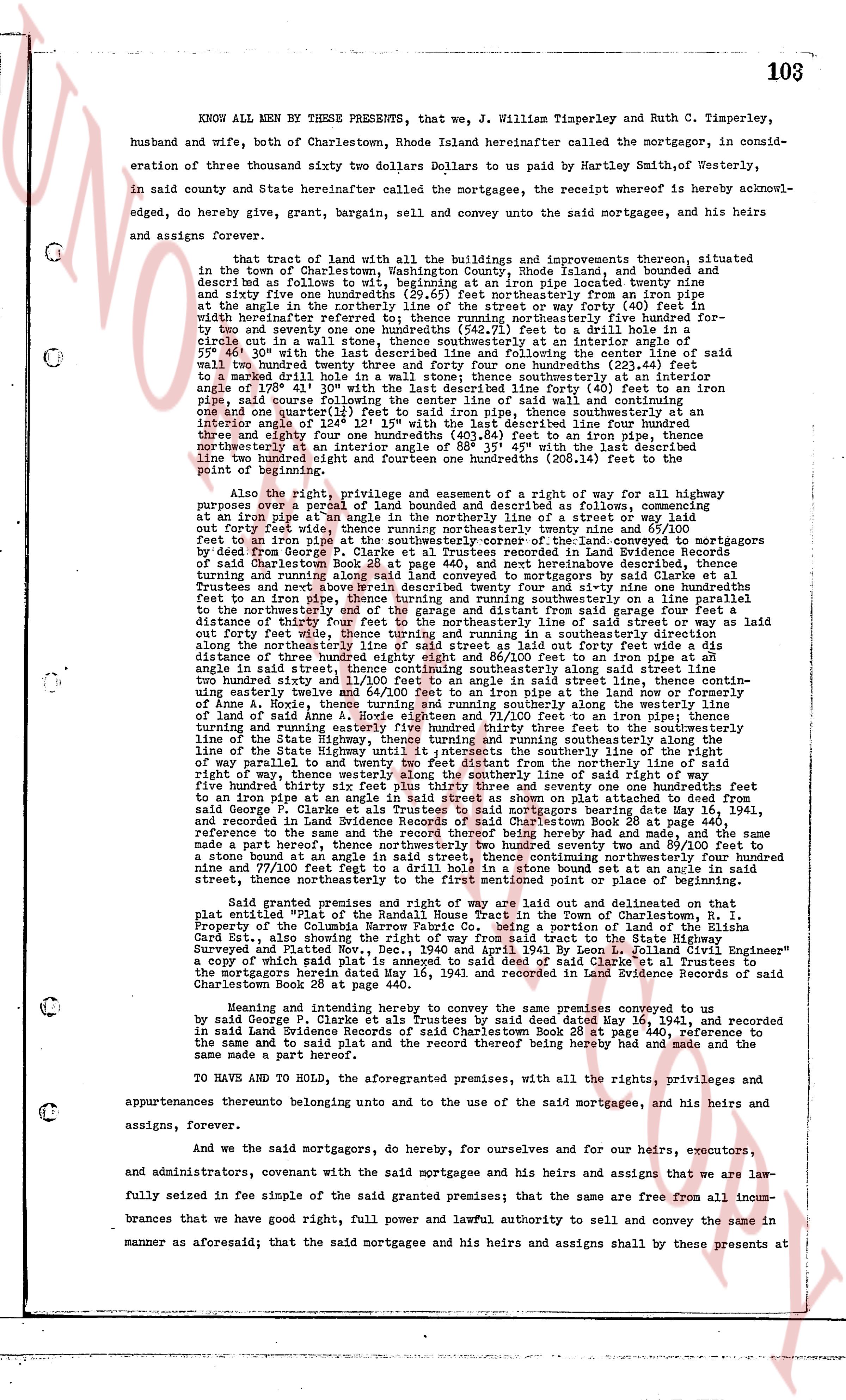
103
KNOW ALL MEN BY THESE PRESENTS, that we, J. William Timperley and Ruth C. Timperley, husband and wife, both of Charlestown, Rhode Island hereinafter called the mortgagor, in consideration of three thousand sixty two dollars Dollars to us paid by Hartley Smith, of Westerly, in said county and State hereinafter called the mortgagee, the receipt of whereof is hereby acknowledged, do hereby give, grant, bargain, sell and convey unto the said mortgagee, and his heirs and assigns forever,
That tract of land with all the buildings and improvements thereon, situated in the town of Charlestown, Washington County, Rhode Island, and bounded and described as follows to wit: beginning at an iron pipe located twenty nine and sixty five one hundredths (29.65) feet northeasterly from an iron pipe at the east line of the road in said town, and forty feet to a nail in a stone wall in said whirlwind referenced therefore to; running northeasterly four hundred ninety five and two hundred seventy one one hundredths (495.71) feet to a nail driven into a circle cut in a wall stone, thence southwesterly at an interior angle of 50° 30' with the last described line four hundred twenty four and one quarter (424.25) feet to a nail driven into a wall stone, thence northeasterly at an interior angle of 231° 40' with the said last described line four hundred twenty one and three quarter (421.75) feet to an iron pipe under the ground, thence southeasterly at an interior angle of 128° 41' 30" with the last described line forty (40) feet to an iron pipe, said iron pipe being at an interior angle of 138° 27' with said nail and wall stone, thence southwesterly one and one quarter one hundredth (1.25) feet to said iron pipe, thence southwesterly at an interior angle of 112° 15' 30" with the last described line four hundred twenty one and three eighty four one hundredths (421.84) feet to an iron pipe, thence northeasterly at an interior angle of 88° 35' 45" with the last described line two hundred ninety eight eighty one one hundredths (298.81) feet to the point of beginning.
Also the right, privilege, and easement of a right of way for a highway multipurpose over a parcel of land bounded and described as follows, commencing at an iron pipe at an angle of the northeasterly line of a street or way laid out forty feet wide in said town, thence running northeasterly twenty nine and one hundredths (29.01) feet to an iron pipe at the southeasterly corner of the land conveyed to the mortgagees by deed in Land Evidence Records of Charlestown, Rhode Island, in book 28 page 440, records of said Charlestown Book 28 page 440, and next hereabove described, thence turning northerly and running northwesterly one hundred twenty nine and one hundredths (129.01) feet to Trustees and a note twelve hundred eighty described twenty nine and sixty nine one hundredths feet to the northeasterly line of the road in said town, thence running northwesterly to the northeasterly and to the garage and distant from said garage four feet a distance of twenty four feet to the northeasterly line of the road in said town, as laid out forty feet wide, thence turning and running in a southeasterly direction along the northeasterly line of the road in said town, and continuing in said direction this distance of three hundred eighty eight and 86/100 feet to an iron pipe at an angle of 112° 15' 30" with the last described line along said road, thence running one hundred twenty six hundredths and 31/100 feet to an angle in said street line, thence continuing easterly twelve and 41/100 feet to an iron pipe at an angle line now or formerly of Anna E. Borde, thence turning and running southeasterly one hundred twenty nine and one hundredths (129.01) feet to an angle of land Anna E. Borde eighteen and 71/100 feet to an iron pipe; thence turning and running southeasterly one hundred twenty feet to a nail in a stone wall parallel to the line of the State Highway, thence turning and running southeasterly along the line of the State Highway, thence turning and running southeasterly along the line of way, then turning more or less southeasterly along the line of the State Highway one hundred fifty three hundred thirty six feet plus thirty three and seventy one one hundredths feet to an iron pipe at an angle of 112° 15' 30" with the last described line, and continuing in said direction from said George F. Clarke et als Trustees to said mortgagees bearing date May 16, 1941, and recorded in Land Evidence Records of Charlestown, Rhode Island, Book 28 page 440, with reference to the same and the record thereof bearing here by made and had, and the same as a note hereof, thence turning and running southeasterly one hundred twenty nine and 57/100 feet to a stone bounded at an angle in said street, thence continuing northeasterly four hundred ninety five and 71/100 feet to an iron pipe at an angle of 112° 15' 30" with the last described line in said street, thence northeasterly to the first mentioned point or place of beginning.
Said granted premises and right of way are laid out and delineated on that plat entitled "Plot of the Randall House Tract in the Town of Charlestown, R.I. Property of the Columbus Trust Company" being a portion of the Land Evidence Record Card 23t., also showing the right of way from said tract to the State Highway Surveyed and Platted by "A. S. G. and A. S. G. Civil and Sanitary Engineer" a copy of which said plat is annexed to said deed of said Clarke et al Trustees to the Mortgagees bearing date May 16, 1941, and recorded in Land Evidence Records of Charlestown Book 28 page 440.
Hence and intending hereby to convey the same premises conveyed to the mortgagees by deed in said Land Evidence Records of Trustees by deed dated May 16, 1941, and recorded in said Land Evidence Records of said Charlestown Book 28 page 440, reference to the same and to said plat and the record thereof bearing here by made and had and the same a made part hereof.
TO HAVE AND TO HOLD, the aforementioned premises, with all the rights, privileges and appurtenances thereunto belonging unto and to the uses of the said mortgagee, and his heirs and assigns, forever.
And we the said mortgagors, said do hereby, for ourselves and for our heirs, executors, and administrators, covenant with the said mortgagees and his heirs and assigns that we are lawfully seized in fee simple of the said granted premises; that the same are free from all incumbrances that the we have good, right, full power and lawful authority to sell and convey the same in manner as aforesaid; that the said mortgagee and his heirs and assigns shall always by these presents at
page 2 · read by Gemma vision
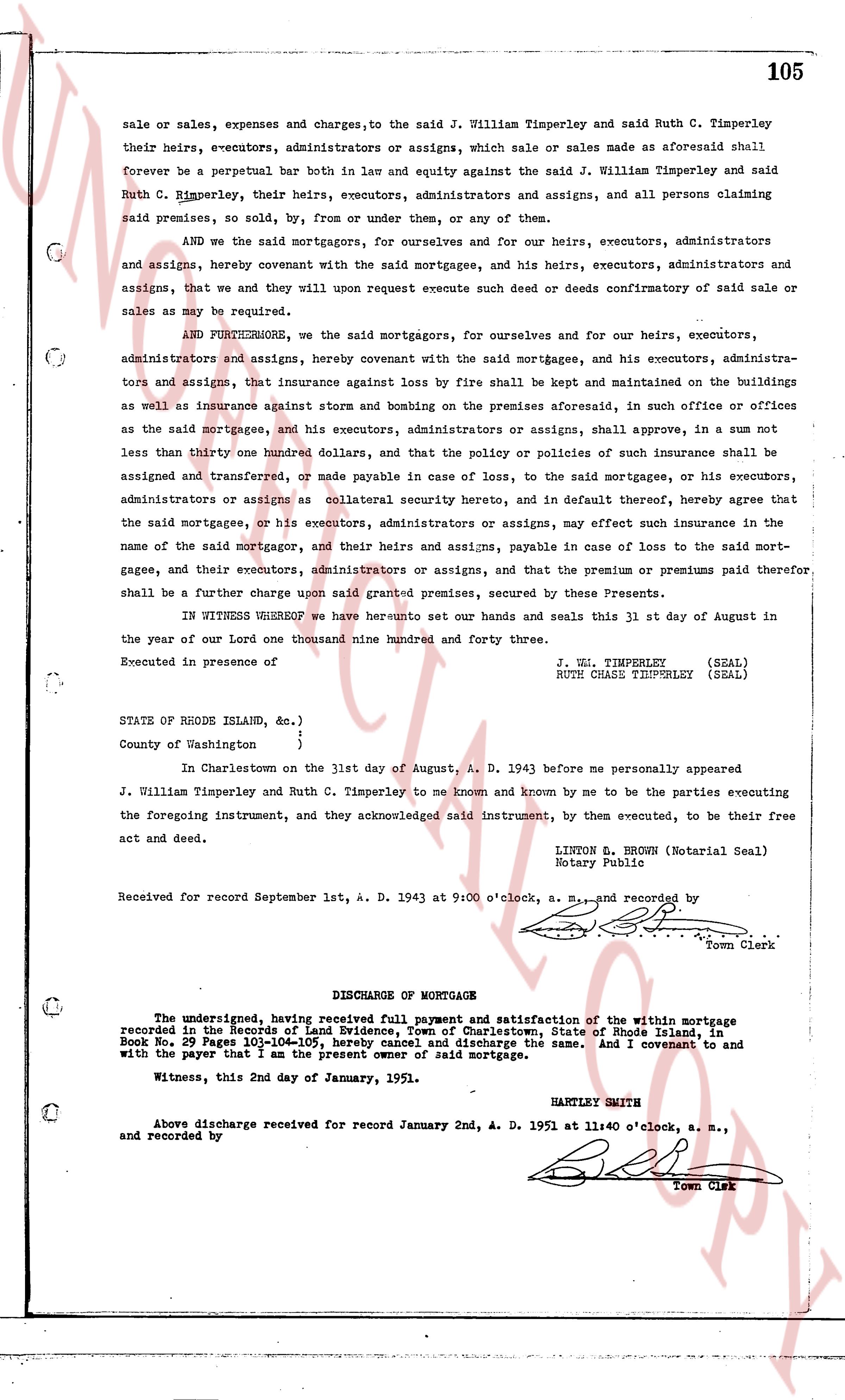
105
sale or sales, expenses and charges, to the said J. William Timperley and said Ruth C. Timperley
their heirs, e-executors, administrators or assigns, which sale or sales made as aforesaid shall
forever be a perpetual bar both in law and equity against the said J. William Timperley and said
Ruth C. Timperley, their heirs, executors, administrators and assigns, and all persons claiming
said premises, so sold, by from or under them, or any of them.
AND we the said mortgagors, for ourselves and for our heirs, executors, administrators
and assigns, hereby covenant with the said mortgagee, and his heirs, executors, administrators
and assigns, that we will upon request execute such deed or deeds confirmatory of said sale or
sales as may be required.
AND FURTHERMORE, we the said mortgagors, for ourselves and for our heirs, executors,
administrators and assigns, hereby covenant with the said mortgagee, and his executors, administra-
tors and assigns, that insurance against loss by fire shall be kept and maintained on the buildings
as well as insurance against storms and bozing on the premises aforesaid, in such office or offices
as the said mortgagee, and his executors, administrators or assigns, shall approve, in a sum not
less than thirty one hundred dollars, and that the policy or policies of such insurance shall be
assigned and transferred, or made payable in case of loss, to the said mortgagee, or his executors,
administrators or assigns as collateral security hereunto reserved, and in default thereof, hereby agree that
the said mortgagee, or his executors, administrators or assigns, may effect such insurance in the
name of the said mortgagor, and their heirs and assigns, payable in case of loss to the said mort-
gagee, and their executors, administrators or assigns, and that the premium or premiums paid therefore
shall be a further charge upon said granted premises, secured by these Presents.
In WITNESS WHEREOF we have hereunto set our hands and seals this 31 st day of August in
the year of our Lord one thousand nine hundred and forty three.
Executed in presence of
J. WM. TIMPERLEY (SEAL)
RUTH CHASE TIMPERLEY (SEAL)
STATE of RHODE ISLAND, sc. )
)
County of Washington )
In Charlestown on the 31st day of August, A. D. 1943 before me personally appeared
J. William Timperley and Ruth C. Timperley to me known and known by me to be the parties executing
the foregoing instrument, and they acknowledged said instrument, by them executed, to be their free
act and deed.
LINTON S. BROWN (Notarial Seal)
Notary Public
Received for record September 1st, A. D. 1943 at 9:00 o'clock, a. m., and recorded by
[Signature]
Town Clerk
----
DISCHARGE OF MORTGAGE
The undersigned, having received full payment and satisfaction of the within Mortgage
recorded in the Town's book of Evidence for the Town of Charlestown, State of Rhode Island, in
Book 29 Page 101-104-105, hereby named and discharge the same. And I covenant to and
with the payer that I am the present owner of said mortgage.
Witness, this 2nd day of January, 1951.
HARTLEY SMITH
Above discharge received for record January 2nd, A. D. 1951 at 11:40 o'clock, a. m.,
and recorded by
[Signature]
Town Clerk
The page as recorded