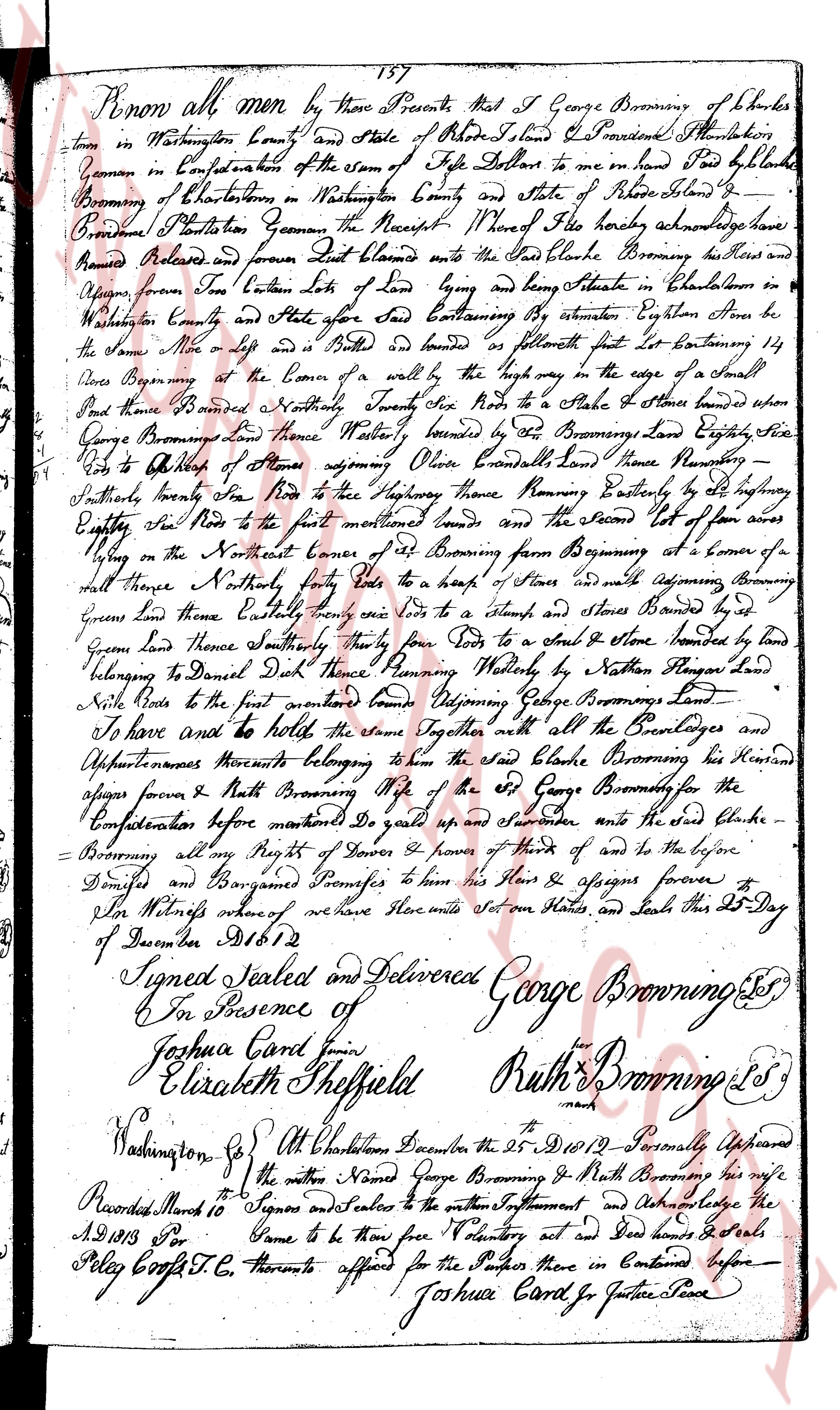
The instrument's own words
page 1
157
Know all men by these Presents that I George Browning of Shelter
town in Washington County and State of Rhode Island Providence Plantation
Yeoman in Confederation of the town of Tiverton do make in hand Paid by Richard
Browning of Shelter town in Washington County and State of Rhode Island
Providence Plantation Yeoman the Receipt whereof the said Richard acknowledge
have
given Released and forever Quit Claimed unto the said Richard Browning his Heirs and
assigns forever Two Certain lots of Land lying and being situate in Colleton in
Washington County and State aforesaid Said Containing by estimation Eighteen Acres be
the Same More or less and is bounded on southeastern part East boundary 14
Rods Beginning at the Corner of a wall by the highway in the edge of a small
pond thence Boundes Northerly Toward Six Rods to the Stake & Stones land where
George Browning land there Westerly bounded by the Browning land Eighteen Five
Rods to the Office of some person opposite Olive Crescent land thence Northerly
southerly seventy five Rods to the highway having Running Easterly by said highway
Forty Six Rods to the first mentioned bound and the Second Lot of four acres
lying on the Northeast corner of said Browning farm from Beginning at a corner of
said there Northerly four feet to a heap of Stones and wall adjoining Browning
green Land there Easterly ninety one Rods to a stump, and Stones bounded by said
green Land there southerly thirty four feet to a stack & stone bounded by land
belonging to Daniel Dick land thence Running Westerly by Nathan Rogers land
Nile Rods to the first mentioned bound Adjoining George Brownings Land
I save and hold to the same Together with all the Privileges and
Appurtenances thereunto belonging to the said Richard Browning his Heirs and
assigns forever and Ruth Browning wife of the said George Browning for the
Confederation before mentioned Do scale up and surrender unto the said Richard
Browning all my Rights of Dower & cover & herde of his and to the before
Described and Bonforaged Premises to him his Heirs & assigns forever
For Witness whereof we have hereunto set our Hands and Seals this 25 Day
of December AD 1812
Signed Sealed and delivered George Browning SS
In Presence of
Joshua Card join
Elizabeth Sheffield Ruth Browning SS
Washington Co. At Charlestown the 25 December the AD 1812 Personally Appeared
the above Named George Browning & Ruth Browning his wife
Signes and Sealers to the within Instrument Do Acknowledge the
Game to be their free Voluntary act and Deed hands & Seals
Joshua Card Jr Justice Peace
Recorded March 10
A.D 1813 Por
Poly Coft C.C.
The page as recorded